
NJwx85
-
Posts
15,544 -
Joined
-
Last visited
Content Type
Profiles
Blogs
Forums
American Weather
Media Demo
Store
Gallery
Everything posted by NJwx85
-
You can’t just call up an airline and change a flight, especially with the small number of flights each day back to NY. Not to mention others will be doing the same.
-
Looks like I picked a bad time to vacation in Ko Olina.
-

August 2018 Discussions & Observations Thread
NJwx85 replied to Rtd208's topic in New York City Metro
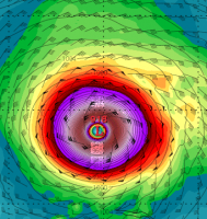
Per latest advisory, looks like Lane is undergoing ERC. -
August 2018 Discussions & Observations Thread
NJwx85 replied to Rtd208's topic in New York City Metro
Lane is obviously strengthening per latest IR loop images. Intesity forecasts seem to be way off. -
August 2018 Discussions & Observations Thread
NJwx85 replied to Rtd208's topic in New York City Metro
True dat -
August 2018 Discussions & Observations Thread
NJwx85 replied to Rtd208's topic in New York City Metro
FWIW the winds are much more significant today. A strong breeze out of the SE vs out of the West and nearly non existent the last two days. That’s the direction Lane is coming from, so I guess we’re already feeling some of the outflow. -
August 2018 Discussions & Observations Thread
NJwx85 replied to Rtd208's topic in New York City Metro
Thanks, hoping for the best. Hopefully the airport will survive the worst of it and we’ll be able to get home on time. As of now, it does look like a glancing blow vs a direct hit, but the forecast trend has been troubling, and a possible recurve right over the islands isn’t out of the question. I’m also worried about landslides and water spouts. As you may know, this side of the island is dry, so runoff will be an issue. -
August 2018 Discussions & Observations Thread
NJwx85 replied to Rtd208's topic in New York City Metro
I don’t think evacuating is an option right now. I guess if things trend stronger, they might order one. As of now, we’re planning to ride it out, not supposed to come home till a week from tomorrow so we’re hoping to salvage at least this weekend and early next week. -
August 2018 Discussions & Observations Thread
NJwx85 replied to Rtd208's topic in New York City Metro
Yeah it’s “cool” but I’m right on the ocean in Ko Olina and I’m not sure how hurricane proof things are here since hits are so rare. The resorts out this way are all less than 20 years old, which was after the last big hit on Ohau. Were going to be in the right front quadrant to boot and the mountains are just to our North which means maximum impacts as far as I can tell. -
August 2018 Discussions & Observations Thread
NJwx85 replied to Rtd208's topic in New York City Metro
I woke up this morning to see that the track of Lane has shifted significantly to the right. The Central Pacific Hurricane Center now says that a hurricane watch could be issued for the NW Hawaiian islands by tonight. The locals here say they can feel the storm coming because the winds have been so calm. The Hurricane has literally sucked away all the breezes as they put it. Unlike the other islands, the poplulated portions of Ohau aren’t protected from the mountains. I guess I picked a bad time to go to Ohau. -
August 2018 Discussions & Observations Thread
NJwx85 replied to Rtd208's topic in New York City Metro
Greetings from Ohau where it’s been unusually warm and rainy. Figures I would travel 6000 miles and have the same weather as home. -
Looks like I have an outside chance of at least a glancing blow from Hurricane Lane in Ohau, however it looks like the guidance has been keeping it just South.
-
August 2018 Discussions & Observations Thread
NJwx85 replied to Rtd208's topic in New York City Metro
The models aren't always right and it's up to the discretion of the forecaster anyway, which aren't always right. In any event, it's a heat advisory, I doubt they spent much time contemplating its validity. -
August 2018 Discussions & Observations Thread
NJwx85 replied to Rtd208's topic in New York City Metro
That's more of an indictment on how humid it's been, that low 90's doesn't feel that bad. Anyway as I'm sure you know, the forecasted indices met the criteria, hence the advisory. -
Tracking The 3”+ Heavy Rainfall Events Since 2010
NJwx85 replied to bluewave's topic in New York City Metro
DIX destroyed OKX this time around. -
On Saturday I’m headed off to Ohau for ten days. I hope to catch some glimpses of the lava flows as we fly past the big island. Does anyone know from how far away the eruptions can be seen?
-
August 2018 Discussions & Observations Thread
NJwx85 replied to Rtd208's topic in New York City Metro
That’s not true in all places. We’ve gone long stretches without seeing the sun up here all Summer. -
August 2018 Discussions & Observations Thread
NJwx85 replied to Rtd208's topic in New York City Metro
Got hammered here overnight. 24 hour total of 5.2” -
August 2018 Discussions & Observations Thread
NJwx85 replied to Rtd208's topic in New York City Metro
The HRRR has been under performing greater than 5 hours out today. The run from late morning just had a few popcorn storms rather than the full blown squall line that verified. Looking ahead, we should get another cluster of storms around 22Z. You can see the some of that activity getting going now to our Southwest. FYI, Flood Watch National Weather Service Mount Holly NJ 327 PM EDT Fri Aug 3 2018 NJZ001-007-008-040400- /O.EXA.KPHI.FF.A.0011.000000T0000Z-180804T1200Z/ /00000.0.ER.000000T0000Z.000000T0000Z.000000T0000Z.OO/ Sussex-Warren-Morris- Including the cities of Newton, Washington, and Morristown 327 PM EDT Fri Aug 3 2018 ...FLASH FLOOD WATCH IN EFFECT THROUGH SATURDAY MORNING... The National Weather Service in Mount Holly has expanded the * Flash Flood Watch to include a portion of northern New Jersey, including the following areas, Morris, Sussex, and Warren. * Through Saturday morning * Scattered showers and thunderstorms into this evening will contain brief, heavy downpours. The threat for flash flooding increases with subsequent rounds of locally heavy rainfall from showers and thunderstorms late tonight into early Saturday morning. * Heavy rainfall within a short period of time can lead to rapidly rising water and flash flooding, particularly in urban areas, along small creeks and streams as the ground is already very saturated due to recent heavy rains over the past two weeks. PRECAUTIONARY/PREPAREDNESS ACTIONS... A Flash Flood Watch means that there is the potential for flash flooding which can be life-threatening. Heavy rain is expected to occur over a short period of time. Rapidly rising flood waters may quickly inundate roadways and areas of poor drainage. Streams and creeks could leave their banks, flooding nearby properties. Please monitor the forecast, especially if you live in a location that is prone to flooding. Be prepared to take action if a flash flood warning is issued for your area. Flood Watch National Weather Service New York NY 306 PM EDT Fri Aug 3 2018 CTZ005>012-NJZ002-004-006-103>108-NYZ067>075-078>081-176>179- 040815- /O.NEW.KOKX.FF.A.0006.180803T1906Z-180804T1600Z/ /00000.0.ER.000000T0000Z.000000T0000Z.000000T0000Z.OO/ Northern Fairfield-Northern New Haven-Northern Middlesex- Northern New London-Southern Fairfield-Southern New Haven- Southern Middlesex-Southern New London-Western Passaic- Eastern Passaic-Hudson-Western Bergen-Eastern Bergen- Western Essex-Eastern Essex-Western Union-Eastern Union-Orange- Putnam-Rockland-Northern Westchester-Southern Westchester- New York (Manhattan)-Bronx-Richmond (Staten Island)- Kings (Brooklyn)-Northwestern Suffolk-Northeastern Suffolk- Southwestern Suffolk-Southeastern Suffolk-Northern Queens- Northern Nassau-Southern Queens-Southern Nassau- 306 PM EDT Fri Aug 3 2018 ...FLASH FLOOD WATCH IN EFFECT THROUGH SATURDAY MORNING... The National Weather Service in Upton has issued a * Flash Flood Watch for portions of southern Connecticut, northeast New Jersey, and southeast New York, including the following areas, in southern Connecticut, Fairfield, Middlesex, New Haven, and New London. In northeast New Jersey, Bergen, Essex, Passaic, Union, and Hudson. In southeast New York, Bronx, Kings (Brooklyn), New York (Manhattan), Suffolk, Nassau, Queens, Westchester, Orange, Putnam, Richmond (Staten Island), and Rockland. * Through Saturday morning * Showers and thunderstorms moving across the area will become widespread this afternoon and through Saturday morning with locally heavy downpours. This will result in a threat for flash flooding through Saturday morning across the region. * Flash flooding of urban areas will be possible where locally heavy rainfall occurs. Locations that have already received substantial rain in the last couple of days will be particularly vulnerable. PRECAUTIONARY/PREPAREDNESS ACTIONS... A Flash Flood Watch means that conditions may develop that lead to flash flooding. Flash flooding is a very dangerous situation. You should monitor later forecasts and be prepared to take action should flash flood warnings be issued. && -
August 2018 Discussions & Observations Thread
NJwx85 replied to Rtd208's topic in New York City Metro
And we're not done. More storms are firing over DE, S NJ and E PA. -
August 2018 Discussions & Observations Thread
NJwx85 replied to Rtd208's topic in New York City Metro
Almost an instant flash flood here. About an inch of rain in less than five minutes. Unreal. Very windy out ahead of the line with lots of lightning and even some swirling evident in the clouds. -
August 2018 Discussions & Observations Thread
NJwx85 replied to Rtd208's topic in New York City Metro
Radar looks wicked. Embedded severe as well. -
August 2018 Discussions & Observations Thread
NJwx85 replied to Rtd208's topic in New York City Metro
Pouring here for the last 20 minutes with a few rumbles of thunder. -
August 2018 Discussions & Observations Thread
NJwx85 replied to Rtd208's topic in New York City Metro
Have a great view of the tremendous cumulous tower skirting by to my Northwest headed towards the Orange/Rockland border from Western Passaic. -
August 2018 Discussions & Observations Thread
NJwx85 replied to Rtd208's topic in New York City Metro
Radar is exploding over PA and most of NJ.
