
NJwx85
-
Posts
15,544 -
Joined
-
Last visited
Content Type
Profiles
Blogs
Forums
American Weather
Media Demo
Store
Gallery
Everything posted by NJwx85
-
It's completing an ERC as we speak and not even flinching. Irma acted similarly.
-
Would this count as a US landfalling Cat 5 since PR is a US territory?
-
Does anyone know what the terrain is like on St Croix? I'm wondering if a direct hit there could disrupt the core similarly to what happened with the impact to Dominica. Obviously it would be terrible news for St Croix but it might save PR from total catastrophic impact.
-
It was very small, but it's growing.
-
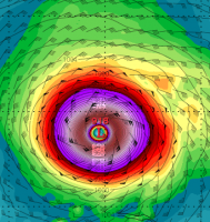
-70C tops now showing up on the Eastern side of the hurricane. Also the CDO continues to become larger and more uniform. It seems that if an ERC is approaching, it will be very slow to occur. My guess is that the center will come ashore before any significant weakening occurs.
-
Some additional strengthening is possible this evening before the outer eyewall becomes better defined or the cyclone reaches its maximum potential intensity. It now appears likely that Maria will be at category 5 intensity when it moves over the U. S. Virgin Islands and Puerto Rico, although there is a chance that the start of the eyewall replacement cycle might reduce the intensity a little bit. The hurricane should weaken as it crosses Puerto Rico, and after that proximity to Hispaniola and less favorable upper-level winds are likely to lead to continued slow weakening. The new intensity forecast remains at the upper edge of the intensity guidance.
-
SUMMARY OF 500 PM AST...2100 UTC...INFORMATION ---------------------------------------------- LOCATION...16.8N 64.0W ABOUT 80 MI...130 KM SE OF ST. CROIX ABOUT 175 MI...285 KM SE OF SAN JUAN PUERTO RICO MAXIMUM SUSTAINED WINDS...165 MPH...270 KM/H PRESENT MOVEMENT...WNW OR 300 DEGREES AT 10 MPH...17 KM/H MINIMUM CENTRAL PRESSURE...916 MB...27.05 INCHES
-
The CDO has grown substantially in size today.
-
The long range JKUA radar shows a very small and symmetrical eye with intense convection now completely wrapped around. Furthermore, no real signs of an outer eyewall at this time. Unless recon finds a secondary wind maxima I would hold off on the ERC talk.
-
If you've noticed, Maria seems to follow Jose, thus Maria's eventual fate is very much reliant on the eventual outcome of Jose. If you're looking for an East coast landfall from Maria, you want Jose to either dissipate or move far enough West that it allows the ridge to rebuild to the North. If Jose ends up getting kicked out, it leaves the weakness in place and Maria likely follows.
-
Yeah I did say that, because that's what should have happened. The trough is way back over the Northern plains as Maria is approaching coast. Either way, it's still a solid battering for many.
-
The Euro says the trough kicks Maria OTS at the very last second, I don't see it. Anyway it's a day 8-9 forecast. Just good to see an exciting model run
-
Imminent landfall, probably into NJ
-
See no reason why Maria wouldn't follow Jose WNW.
-
Hold onto your hats, the 12z ECMWF takes what's left of Jose and buries it into the NJ coast rather than kicking it NE. That allows the ridge to rebuild to the North and East.
-
Oh okay thanks.
-
I'm surprised they issued a special advisory for a 5MPH increase.
-
The Euro takes the eye pretty much right over the NE corner of PR.
-
Looks like Maria is up to max winds of 170mph per latest recon.
-
The mountains are located to the South and Southeast of San Juan, and the winds should be out of East, Northeast, especially once the center moves onshore.
-
Here is a picture of the very beautiful resort area known as Isla Verde, about a half hours drive East of downtown San Juan. It's located very close to where the airport is, which is behind the resort in the very bottom left corner of the picture. The area behind these hotels is a highly populated residential area which is located in a valley. The higher terrain is a good distance to the Southeast of this location, on the other side of the airport.
-
Well that's why I specifically stated that the potential surge impact area was near the Port. The resort area however is about 20 miles to the East, in a very low lying area.
-
I guess they are expecting landfall a bit South of the model consensus.
-
I have stayed at the Marriott twice which is almost right next door. The area directly behind the resorts is very flat as well, with many one story homes and buildings. A 6-9' storm surge could submerge a lot of neighborhoods.
-
Agreed. San Juan is close to where I placed this red dot.

