

hlcater
-
Posts
2,638 -
Joined
-
Last visited
Content Type
Profiles
Blogs
Forums
American Weather
Media Demo
Store
Gallery
Posts posted by hlcater
-
-
33 minutes ago, OrdIowPitMsp said:
Snow squall development occurred to our west and we were placed under a WWA, it’s currently puking big fat flakes. Too bad it’ll be short lived because this is SN+
That should track all the way down here throughout the day. Could be an interesting hour or two this evening.
-
-
I dont see much, if any, reason to be considering the GFS seriously at this stage. Seen this time and time again.
-
 1
1
-
-
Interesting to see that LOT graphic basically mimic the GFS in terms of heavy snow spread. Must think the rest of guidance is out to lunch.
Wonder if we can get some insight on that decision? Seems bold to go with a model that is objectively the outlier.
-
Now for the GFS to come south
-
 1
1
-
-
Just now, Baum said:
ok.
I've always kind of been a closet UKMET truther. It's kinda been blowing chunks this year though
-
1
-
-
Canadian and UKMET remain south. A hair north on the UKMET and a fairly substantial jump north from the Canadian. Still well south of the GFS. As much as I'd like to believe, I don't really see a scenario where the GFS is correct and everything caves towards it.
-
1
-
-
Holy shit the GFS. What do I need to do to make that happen
-
2
-
-
UK and Canadian still south of the GFS.
-
Bet against the amped system
-
 1
1
-
-
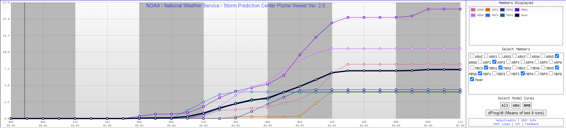
I dont know how this compares with the 00z but the 12z EPS mean is substantially further north than the operational. Especially with eastward extent.

-
 1
1
-
-
26 minutes ago, Hoosier said:
While you're at it, can you post the Euro FRAM output?

-
12z euro is stronger and perhaps a touch NW.

-
There's still 108 hours left on this one. Plenty of time for things to change for better or worse.
-
1 hour ago, cyclone77 said:
Yeah it's been a rough stretch. On the bright side we're building some good weather karma I guess lol.
Reeling in the D4
-
19 minutes ago, Chicago Storm said:
if you insist.
.Why did you start a threat at the behest of someone named “solidice”. Do you know what you’ve done?
-
2
-
-
Also the low coming out is much more organized at the surface-700mb layer than the last system. Should yield a higher probability of heavier rates for someone.
-
2
-
-
-
18 minutes ago, IllinoisWedges said:
Why do any of us care
someone is butthurt because deep down he knows that the writing is on the wall for chicago and he just hates to see it
-
1
-
4
-
-
5 minutes ago, WeatherMonger said:
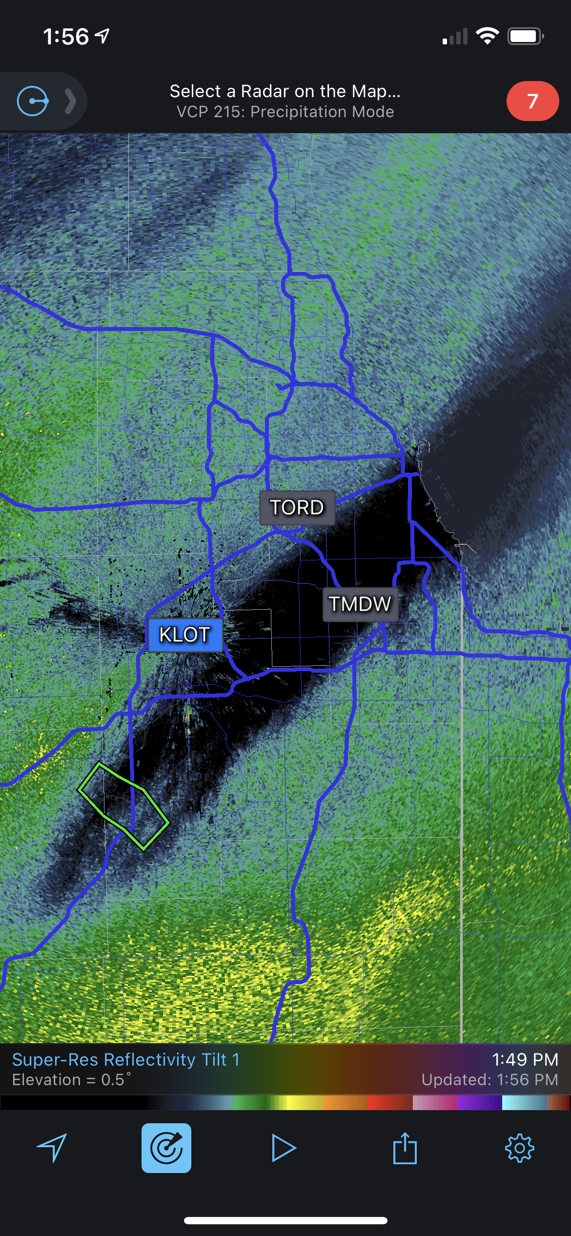
Not sure where to check, are there any reports of snow hitting the ground on the NW side of precip shield? Radarscope shows it both ILX and DVN radars. Thicknesses support it.
One of my friends that was driving from STL to IC said snow in far NE MO near Ft. Madison
-
I prefer 300 pages of whining, ICON runs and backyard predictions. Not sure what this 34 page/thread crap is all about
-
4
-
1
-
4
-
-
SREF mean for KCID is surprisingly good and is up to 7.5". I took the liberty of removing a bunch of unrealistic clunks to get a more accurate reading, of course.
Cant wait for this one.
-
1
-
-
3 minutes ago, KokomoWX said:
Thanks. I updated my original post.
He’s not terrible anymore. Bordering on decent even
-
1
-
-
9 minutes ago, KokomoWX said:
For those interested, here is a nice video on the upcoming storms. (Trained meteorologist) He did a nice job on the recent nor'easter.
He’s not a meteorologist and used to be abysmal. Ever since he crashed his “storm seeker” in Texas he’s been humbled and kinda cleaned up his act a bit even.
-
3
-

February 2022 General Discussion
in Lakes/Ohio Valley
Posted
KCID and MPING reports seemingly suggest the band has transitioned nearly entirely to snow in the CR/IC corridor.