

hlcater
-
Posts
2,638 -
Joined
-
Last visited
Content Type
Profiles
Blogs
Forums
American Weather
Media Demo
Store
Gallery
Posts posted by hlcater
-
-
1 minute ago, Superstorm93 said:
Incredible watching an obviously sheared cyclone intensify anyways. Especially one that just finished an EWRC in the face of that shear. I really wasn’t 100% certain it’d be able to stabilize the core after the EWRC, let alone intensify at a fairly rapid pace.
-
 4
4
-
-
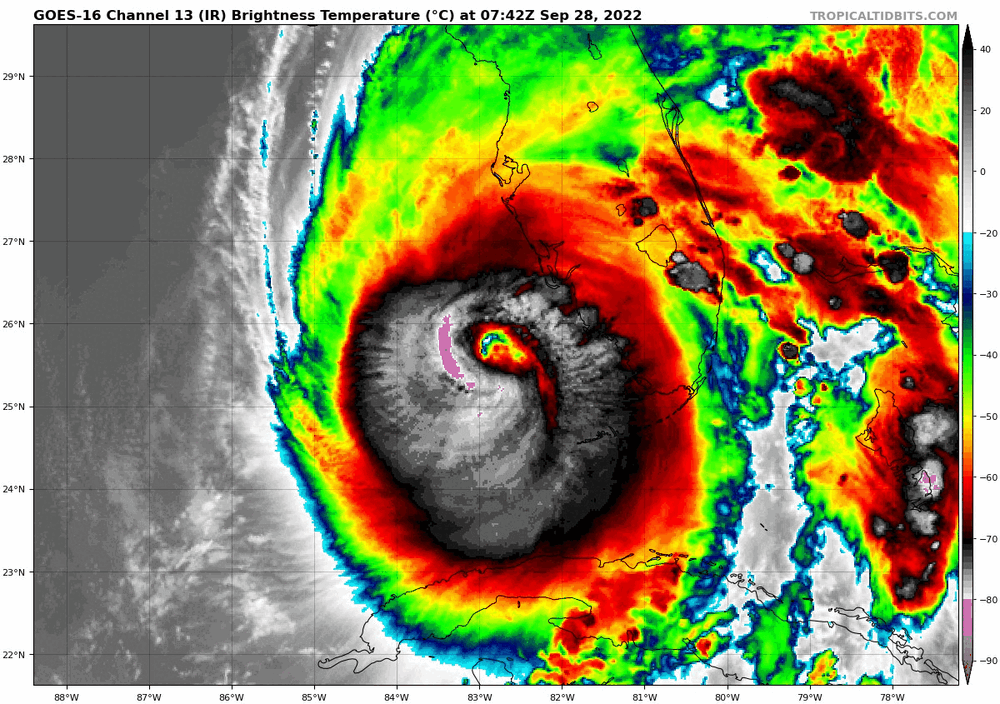
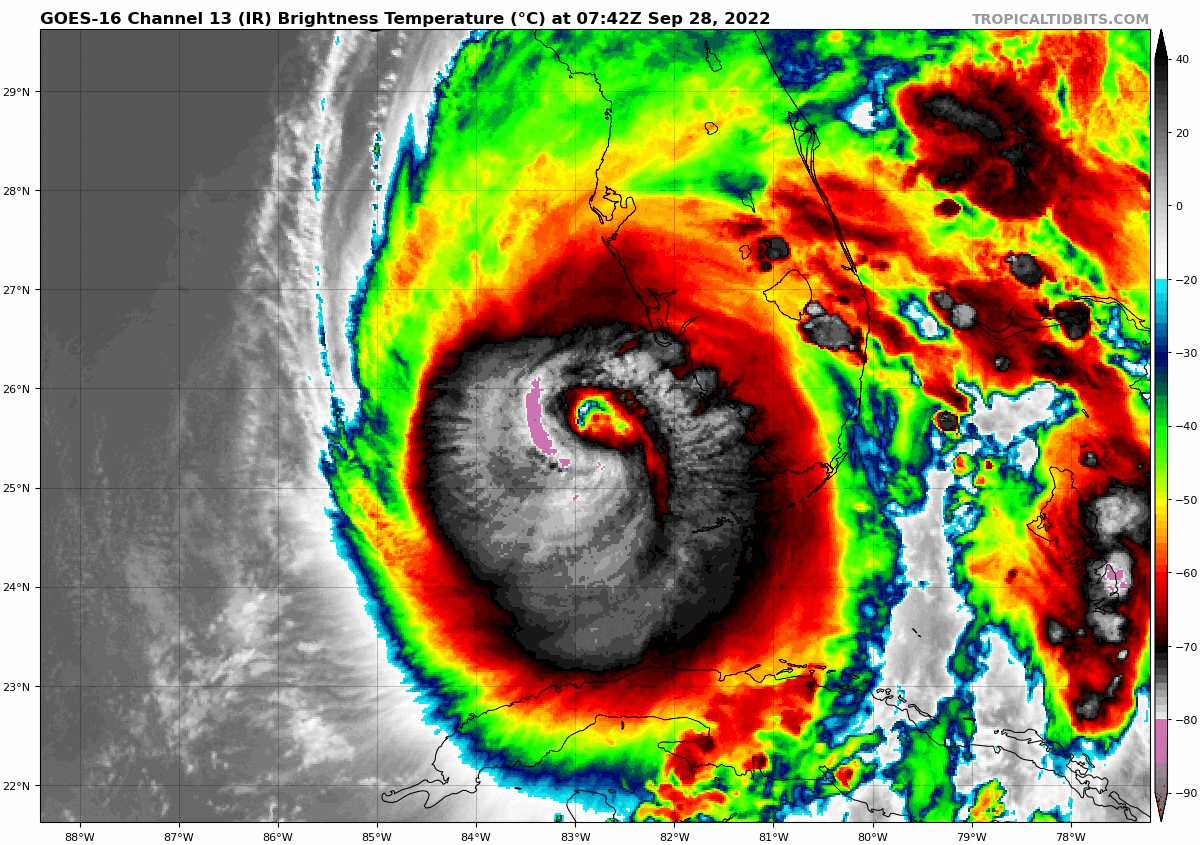
FL winds exceeding 140kts in the NE quad. SFMRs of 110kts. Pressures ~942. Probably see an upgrade to cat 4 here on the 5am update.
-
The fact that the deepest convection is actually on the upshear side of the cyclone likely heralds intensification/resilience in the face of shear at least during the next 6-12 hours.
-
2
-
 1
1
-
-
2 minutes ago, CoastalWx said:
Daytime heating boosting that 0-3KM CAPE helps.
That and there’s no one there to report waterspouts
-
2
-
-
Just now, Intensewind002 said:
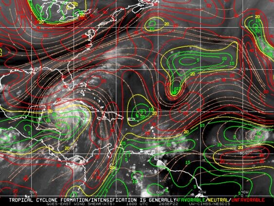
I thought shear was supposed to ramp up big time by late tonight? If Ian doesn’t close off the new eyewall by then, the shear is going to inject a ton of dry air and erode away the southern periphery of the hurricane. Or so I would think…
Correct.
15kts by 15z tomorrow and probably 20-25kts by landfall.
-
1
-
-
Ian is bombing out right now and 115mph is probably a tad conservative. 4-5 hours over flat western Cuba is likely to slow or halt intensification, but probably not enough to hinder it much by tomorrow afternoon.
EDIT: landfall declared, 110kts/952mb.
-
2 minutes ago, CoastalWx said:
Still lots of dry air I think in nrn half of the storm.
This is not supported on the NOAA9 flight. Could be the storm shaking off dry air from earlier today.

-
recon observations are generally consistent with a category 2 hurricane. ~966mb, 80-85kt SFMR, ~85-90kt FL wind. The data is full of holes, hence the ranges.
-
1
-
-
12 minutes ago, olafminesaw said:
Starting to move into shear, but as other have said, a more easterly movement would mitigate
That pocket is moving with the storm.
At least it will for awhile -
17 minutes ago, Superstorm93 said:
Really, really weird call raising the intensity to 85 knots right before you have two recon planes in the storm.
Oh well. We'll see how that works out I suppose.
The core is cleaner on cayman’s radar and MW passes. Seems justified to me. But we shall see.
-
New flight suggests only modest pressure falls over the past few hours. Though, notably, the storm's organizational structure has improved, with 50kt winds now showing up immediately SE of the center in what is likely a nascent inner core.

-
1
-
-
-
The fact that people still take ldub's bait is more amusing than ldub himself
-
3
-
3
-
-
8 minutes ago, hawkeye_wx said:
Models are pretty consistently predicting notable weakening if this storm gets into the northern gulf and starts sucking in the dry air behind the big trough. The 18z GFS shows the storm really collapsing over the last 36 hours prior to landfall.
The synoptic configuration modeled in the 48 hours prior to landfall is definitely something more reminiscent of storms in the early 2000s and not recent years. That big longwave trough is gonna deposit a massive dry airmass in its wake that will likely impact the storm greatly.
-
2
-
-
48 minutes ago, Newman said:
Sable Island is at the max like 30 feet tall. Cut those 50 foot waves south of the island to like 25 feet and it's still tragic.
50ft waves will break offshore and be much less impressive. The surge is almost certain to inundate a good portion of the island though
-
1
-
-
setup overall is very supportive of supercells and large hail with 0-6km shear potentially exceeding 60kts and MLLRs exceeding 7.5. Boundary is somewhat diffuse and not likely to be overforced. Not sold on tornadoes but will likely be out there.
-
1 hour ago, Ed, snow and hurricane fan said:
IIRC, back when I paid, and Joe Bastardi didn't just rant on politics, he said the path of WPAC TCs are sometimes mirrored a couple of weeks later in ATL storms. Just on that, Muifa and Nanmadol would suggest 7L could impact the East Coast, I can't remember if Bastardi ever gave a reason, maybe it was empirical, maybe WPAC storms that entered the mid-latitudes further W than usual influenced the East Coast trough/ridge pattern.
JB has not tweeted weather today.
What does the BSR say?
-
Erika part 2!!
-
Conditions are only marginally conducive for the next several days. Shear isn't actually too bad with values fairly consistently between 10-15kts or so, but there's just an enormous amount of dry air hanging out in the central/tropical atlantic at the moment with frequent intrusions shown on both the GFS and EC. The moisture envelope improves somewhat once TD7 tracks near/north of the greater antilles.

-
1
-
-
Wouldn't be surprised to see a run at major status. Water temps are marginal but there is still quite a bit of CAPE available due to cold air aloft. Outflow pattern is good/excellent over the next 72 hours.
-
hype level 3/10 with potential to increase that in the coming days
-
pretty weak sauce rn
-
20 hours ago, hawkeye_wx said:
The Freeport area is getting clobbered again this morning. 24 hours ago they got 4-8 inches of rain. This morning the same stations are getting another 3-5".
Meanwhile, much of southern Iowa has received less than an inch over the last 30 days.
We really did get lucky over the past week or so. Far enough southeast to avoid 10-15" of rain, but far enough northeast to avoid expanding drought conditions. Zero complaints here.
-
2
-
-
Looked for a second earlier this spring that we might escape our drought that’s been ongoing since 2019. However the next 10 days, and summer as a whole, is looking rather bleak for precip chances in the western sub.
Julia | 85 mph 982 mb peak | EPAC Crossover #2
in Tropical Headquarters
Posted
GEFS likes this one as well