

hlcater
-
Posts
2,638 -
Joined
-
Last visited
Content Type
Profiles
Blogs
Forums
American Weather
Media Demo
Store
Gallery
Posts posted by hlcater
-
-
1 hour ago, klw said:
this would seem to be an interesting run of the GFS

I've noticed there seems to be a problem with the GFS over-amplifying TCs lately. It was doing this last week too and has in the EPAC as well, although to a lesser extent. I'm pretty sure the GFS just had an update recently and this update brought a bit of an over-amplifying issue it seems. Either way, I wouldn't buy that, although decent strengthening is probable, just not to 870mb.
-
A strong June EML remains my biggest concern, although its really too far out to make this call, I really dont like that the past several GFS runs all have a very strong capping regime, so even if we do get excellent wind fields and solid CAPE, it may not matter. However, the main part of the trough is in Canada, which probably contributes at least a little to the whole plains being capped off. If the trough is able to slide south some and not eject so far north, I feel like eroding it should become much easier. This trough also has a huge area of 50kts+ 500mb flow, which is excellent for June, would be a shame to see it largely go to waste.

-
27 minutes ago, cyclone77 said:
For two runs in a row now the EC has a relatively decent setup over the eastern Dakotas/western MN for Friday. Hopefully it's on to something as the GFS is quite different. Decent mid-level flow arrives atop a plume of deep moisture/instability. Wind profiles look pretty respectable. Something to watch anyway.
In the EC's defense, the GFS verification scores are quite terrible lately. I saw a graph 2 or 3 days ago showing the scores, and the GFS is way(like significantly) lower than the Euro for the past week or so. I don't exactly know where to find it though.
-
 1
1
-
-
1 hour ago, bjc0303 said:
12z ECMWF while somewhat north/west for Wednesday suggests a similar level of severe threat.
Friday looks weird. CAA regime really ****s with cyclogenesis.
That low up in near Sioux City is the key, that needs to lift north and/or be not nearly as strong with the CAA or else cyclogenesis will probably have a bit rougher of a time.
-
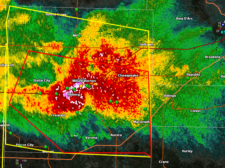
That is one mean HP supercell. Complete with a few idiots core punching(though GPS locations may be a few minutes behind I guess). At least tennis ball size hail in there I'd wager, based on CC values below 80% in places.
-
1 hour ago, Chinook said:
Typhoon Malakas at about the strongest point. The people of Taiwan must feel like a bad weather magnet recently. Typhoon Malakas maxed out at Cat 4, 115 kt at Sept. 16, 18z, reasonably close to Taiwan. Image is from Sept. 16, 2020z. Now it is moving toward southwestern Japan.

Is it just me or does the JTWC have a tendency to over estimate wind speeds. That doesn't look on par with a cat 4 due to a filled eye and no convection north of the center. Wasn't an issue on meranti before it entered the south China sea. Then I think they were over a little. I see lots of storms given ratings, that, based on satellite appearances do not look that steong. However I'm not familiar with the Dvorak classification or whatever thing they use to determine pressure and intensity.
August 21, 2017 Solar Eclipse
in Lakes/Ohio Valley
Posted
Bad news:
The nailed sandy part really got me though lol.
(EDIT: if this should be in the banter thread, feel free to put it there.)