

hlcater
-
Posts
2,638 -
Joined
-
Last visited
Content Type
Profiles
Blogs
Forums
American Weather
Media Demo
Store
Gallery
Posts posted by hlcater
-
-
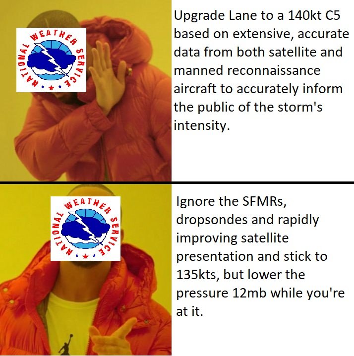
154kts. OH WOULD YOU LOOK AT THAT. I, for one, am surprised.
-
 1
1
-
-
-
Just now, HillsdaleMIWeather said:
And if the island containing Honolulu gets hit, who takes over then?
Probably the NHC.
-
2 minutes ago, nycwinter said:
they will have to revise the strength of this storm to a cat 5 in the future..after reviewing all the information..
Also because the NHC will do that because Lane was an eastern pacific storm. Probably with some collaboration from the CPHC though.
-
24 minutes ago, the ghost of leroy said:
I didnt realize they're just regular WFO honolulu employees and not even tropical specialists...makes me want to pull my hair out AND empathize with them a little
Yea they’re definitely in over their heads here. Central pacific doesn’t deal with many strong cyclones, let alone ones that pose a threat to the islands.
-
New recon is in the air, but probably won't make it before the 03z advisory. Not that CPHC uses recon... But satellite presentation has gradually improved, perhaps that will convince them to upgrade?
-
 1
1
-
-
Lots of people throwing up their arms at that call. Ya'll aren't the only ones.
-
Just now, WxWatcher007 said:
I mean just look at the mean wind in the lowest 150 meters. Insane lol. Is it too much to ask for another center pass? :p
I'd be surprised if it isn't upgraded in the next advisory.
Product: Air Force Vortex Message (URPN12 KNHC)
Transmitted: 21st day of the month at 23:21Z
Agency: United States Air Force
Aircraft: Lockheed WC-130J Hercules with reg. number AF97-5306
Storm Number & Year: 14 in 2018
Storm Name: Lane (flight in the Northeast Pacific basin)
Mission Number: 9
Observation Number: 21 ( See all messages of this type for this mission. )
Remarks Section:
Maximum Flight Level Wind: 146kts (~ 168.0mph) which was observed 10 nautical miles (12 statute miles) to the NE (38°) from the flight level center at 22:41:00ZI wish, but they've already stayed past their scheduled time and are probably running low on fuel.
-
Dropsonde from the northern eyewall. Value closest to surface is 148kts, however it doesn't say surface explicitly, so I'm going to assume its just above and something happened to it before it made splashdown. Normally it'll say (surface) in parenthesis if everything goes right. Even then, the value would almost have to be ~140kts. My guess for the 00z advisory is 140kt/928mb.

-
1
-
-
1 hour ago, LongBeachSurfFreak said:
Outflow looks near perfect in all quadrants currently so it’s definitly maximizing its potential. No signs of shear yet in the SW quadrant. Well see what effect that has soon as it should start to feel the shear in the next 24 hours.
If you really look, I can notice a tinge of westerly shear, noted by the ever so slight lopside to the east. Doesn’t seem to really be troubling the hurricane though.
-
The storm stands no chance if it comes up in behind the big island. The combination of wind disruption and downsloping would almost certainly wreak havoc on the inner core of the storm, making quick work of it no matter how strong it is coming in. This would greatly reduce wind impacts on the other islands. However, there would be some pretty hefty rainfall amounts on the big island if this were the case as all the incoming moisture would be effectively wraught out.
-
52 minutes ago, hawkeye_wx said:
Cedar Rapids got hit pretty good this evening. I picked up 1.60" of rain, while the north to northeast side received 3+".
I only got 0.88". Southern Hiawatha easily got 3"+, tons of street flooding on Collins Rd.
-
8 hours ago, buckeye said:
So I know we don't have an official winter of '18-'19 thread started yet, probably because we tend to be one of the more grounded subs on this site...lol.
But glancing around I see the NE folks are starting to drool with talks of how great things are starting to look for them....and yet it's the beginning of August and 4 months out from met winter beginning. Only thing I'm sure of is that political outcomes and winter forecasts have about the same verification chances when the predictions are made months in advance.
Also keeping in mind no one ever predicts a slow, awful winter. It's always gonna be the coldest, snowiest, record shattering gung ho winter of all time in the preceding August. I just keep my sanity and dont really pay attention until November at the earliest
-
On 8/7/2018 at 1:24 PM, yoda said:
Do subtropical storms count if the storm never becomes tropical? I am guessing so.. just wondering
Yes. Subtrops that never go tropical are still named and counted in post-season analysis.
-
looks like the DTX/SE MI no watch streak is now over
-
5 hours ago, Amped said:
ECMWF not turning Hector north or shearing it apart.
New forecast contest: What day does Hector dissipate?
Typhoon/Hurricane John 31 days is the record. Hector needs to make it to 8/31 to beat that.
I think hector has serious potential to make it all the way well into the west pac. Some weenie runs even have it making landfall in Asia? Realistically, the only thing I can see weakening it for the next 7 days is dry air. Upper air pattern generally has under 15kts shear through this period. However, there is quite a bit of dry air forecast to be around the system that may intrude from time to time. SSTs are conducive, albeit not for a particularly intense storm, more than enough to survive off of.
-
22 hours ago, beavis1729 said:
July 2018 will end as the warmest July on record in Key West FL, with a mean temp of 86.9F. Even so, it's only a +2.3F departure from the 1981-2010 normal.

On July 26th, the max/min was 93/86...yuck.
The only hotter month was August 2007, with a mean temp of 87.5F.
Doesn't take much to get in record departure territory in a barotropic environment.
-
4 hours ago, Stebo said:
Since that last tornado watch date, Jun 22nd 2015, there have been 5 tornadoes in DTX's CWA 4 in 2015 2 EF1s and 2 EF0s, 0 in 2016, 1 EF0 in 2017 and 0 in 2018.
Ow. That’s all I can say.
-
 1
1
-
-
the thread that never dies
-
On 7/19/2018 at 8:34 PM, Jonbo said:
Saw one of them, picture from video capture. Even managed to capture it on video about 15 minutes prior when it was rotating high up pretty strong over my place.
Nice catch! See any more? I was on the storm that tracked from Newton/Monroe/Pella. and got 6. I posted in the lakes/ohio valley thread with my pics. This day will probably end up verifying closer to a 15% than a 2%.
-
wedge tornado in MT/SD was probably easily capable of EF4+ damage. Violent looking for the majority of its life cycle. As of this post, that storm has produced at least 5 tornadoes and is still going strong.
-
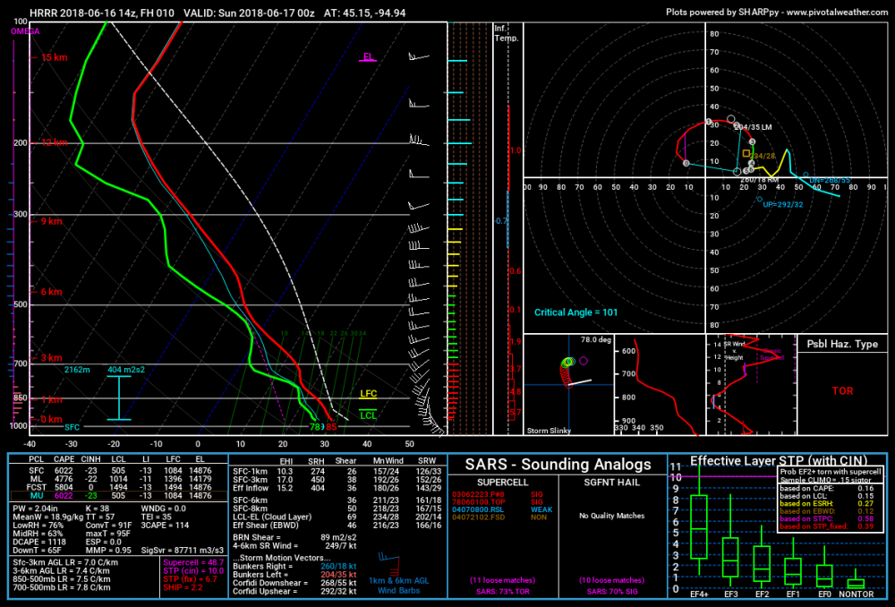
10 hours ago, hlcater said:
Big fan of the warm front in MN today. I’d bet it does something. Weak storm relative winds will probably make storms HP, but 0-1km SRH actually exists with this setup because of that boundary. Storms should initiate as supercells and have a few hours to do something before probable upscale growth.
I forgot what year it is. Nevermind!
-
2
-
-
Can we just fast forward to 2019? Let’s put this poor excuse for a season out of its misery.
-
1
-
-
Big fan of the warm front in MN today. I’d bet it does something. Weak storm relative winds will probably make storms HP, but 0-1km SRH actually exists with this setup because of that boundary. Storms should initiate as supercells and have a few hours to do something before probable upscale growth.

Hurricane Lane impacts Hawaii
in Tropical Headquarters
Posted
I think it looks better than earlier. More symmetrical, and cloud tops are slightly cooler, but it did lose some of the banding.