

hlcater
-
Posts
2,638 -
Joined
-
Last visited
Content Type
Profiles
Blogs
Forums
American Weather
Media Demo
Store
Gallery
Posts posted by hlcater
-
-
7 minutes ago, Windspeed said:
I don't see that recon has made their turn yet. The western wall is getting close to the eastern Dominica coast. We not get that NE pass after all. Perhaps they got spooked. There is a serious incline of elevation that could produce some horrific turbulance. That may be it, folks.
Looks like they're gonna go for it.
-
 1
1
-
-
Just now, andyhb said:
Recon might miss its peak given the core is likely to interact with the mountains on Dominica before the plane arrives.
You think Dominica will have an effect? I personally don't think they'll be enough to significantly hinder the storm.
-
Just now, DopplerWx said:
euro showing jose strengthening over the next 24hrs, not sure about that given the current presentation.
Probably completes transition to purely extratropical and begins redepening that way, while not necessarily restrengthening(could be just expanding). Although I haven't looked at the euro. I'm just making a call based on current presentation and what's forecast.
-
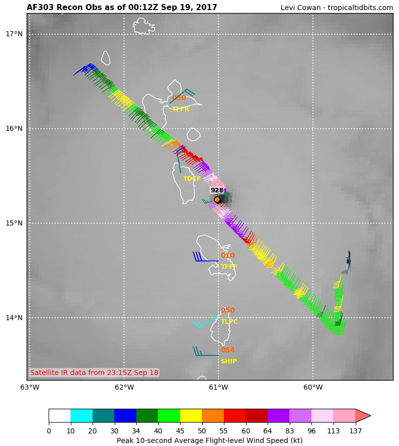
VDM since recon seems to be broken. Main thing I noted was the relatively small 8nm diameter eye. This could help the storm continue to rapidly intensify, but will have to be replaced at some point down the road.
Product: Air Force Vortex Message (URNT12 KNHC)
Transmitted: 18th day of the month at 16:50Z
Agency: United States Air Force
Aircraft: Lockheed WC-130J Hercules with reg. number AF97-5305
Storm Number & Year: 15 in 2017
Storm Name: Maria (flight in the North Atlantic basin)
Mission Number: 2
Observation Number: 22 ( See all messages of this type for this mission. )
A. Time of Center Fix: 18th day of the month at 16:35:00Z
B. Center Fix Coordinates: 14°45'N 60°14'W (14.75N 60.2333W)
B. Center Fix Location: 56 statute miles (90 km) to the E (80°) from Fort-de-France, Martinique (France).
C. Minimum Height at Standard Level: 2,727m (8,947ft) at 700mb
D. Estimated (by SFMR or visually) Maximum Surface Wind Inbound: 104kts (~ 119.7mph)
E. Location of the Estimated Maximum Surface Wind Inbound: 5 nautical miles (6 statute miles) to the SE (134°) of center fix
F. Maximum Flight Level Wind Inbound: From 218° at 101kts (From the SW at ~ 116.2mph)
G. Location of Maximum Flight Level Wind Inbound: 8 nautical miles (9 statute miles) to the SE (134°) of center fix
H. Minimum Sea Level Pressure: 957mb (28.26 inHg)
I. Maximum Flight Level Temp & Pressure Altitude Outside Eye: 10°C (50°F) at a pressure alt. of 3,045m (9,990ft)
J. Maximum Flight Level Temp & Pressure Altitude Inside Eye: 17°C (63°F) at a pressure alt. of 3,038m (9,967ft)
K. Dewpoint Temp (collected at same location as temp inside eye): 12°C (54°F)
K. Sea Surface Temp (collected at same location as temp inside eye): Not Available
L. Eye Character: Closed
M. Eye Shape & Diameter: Circular with a diameter of 8 nautical miles
N. Fix Determined By: Penetration, Radar, Wind, Pressure and Temperature
N. Fix Level: 700mb
O. Navigational Fix Accuracy: 0.02 nautical miles
O. Meteorological Accuracy: 1 nautical mile
Remarks Section:
Maximum Flight Level Wind: 115kts (~ 132.3mph) which was observed 17 nautical miles (20 statute miles) to the E (89°) from the flight level center at 14:41:00Z
Dropsonde Surface Wind at Center: From 245° at 18kts (From the WSW at 21mph)-
1
-
-
20 minutes ago, Powerball said:
Will likely book a room in downtown Dallas in 2024.
No road trip this time though.
Kind of a long walk...
-
My plan was similar to Jackstraw's on the way down in Missouri this morning. Then Waze told me that taking I35 on the way back up was a fantastic idea, and given the lack of any traffic on the way down, I believed it, and that ended just as well as one would expect. So went back to the pretty horrendous Missouri country roads and avoided most of the traffic on the way back to I80. Taking 80 was fine until I ran into an expansive MCS, which I coulda passed in 20 min but it took well over an hour to get out of the rain because people decided that going slower than the storm motion was an absolutely fantastic idea, but that probably would've happened anyways. Country roads were definitely the way to do it, as any interstate that went into totality is clogged from what I've seen and heard.
-
48 minutes ago, hawkeye_wx said:
Thick clouds appear to be moving in from the sw, though.
Held off just long enough to witness complete totality, which lasted about 1:30 seconds in and of itself. Clouds moving in now, but I couldn't care less. I saw what I came to see and it was breathtaking.
-
40 minutes ago, hawkeye_wx said:
If you're near Chillicothe, per your last post, you're in a tough spot. You don't have time to drive far in either direction. Clouds over ne KS are thickening/expanding and moving ne, so I don't think driving west would do you much good. There's a break in the cloud canopy east of KC.
Drove 20 min west, south of Hamilton, MO and have a good view. Got some thin cirrus clouds, but sun is shining through. Got to a good spot with no time to spare.
-
2 minutes ago, cyclone77 said:
Found a great spot south of Arrow Rock MO. Drove through a lot of rain and grunge to get here. Skies are clear in sw and southern sky. Don't know if that clearing will make it here quite in time or not. At least I can see the sun through the clouds already though. Saw a lot of people camping along the highway at various locations along the way. This is like one giant chaser convergence lol.
Sent from my SM-N920V using Tapatalk
I'm in a tear, west or south...
-
Heading to Chillicothe, MO and hoping to dodge the clouds. Doesn't look great, but prospects seem better there than they do further westward.
-
22 minutes ago, cyclone77 said:
Made it to Osceola. Saw quite a few patrol vehicles on the way in on route 34.
Came in to Chariton via 80 and 14 and 80 was full, but still flowing with no issues and 14 had no traffic, even less than normal. Also didn't see a single patrol vehicle along the way, kinda unusual given the increased traffic volume
-
Quote
AREA FORECAST DISCUSSION
National Weather Service Kansas City/Pleasant Hill MO
303 PM CDT Wed Aug 16 2017
.Specifics for the Total Solar Eclipse on August 21st...
Issued at 303 PM CDT WED AUG 16 2017

Model projections continue to show an fairly unsettled weather
pattern early next week as zonal flow along the northern periphery
of a southeastern U.S. ridge impacts the area. Under this
configuration, passing shortwave disturbances appear likely, and
latest model trends support remnant convection early Monday
morning with additional activity possible during the afternoon
hours. Considering we`re still 4+ days out, a lot can still
change, but overall trends this afternoon continue to support the
notion that cloud cover will be present to at least some degree
over the Lwr Missouri Vly early Monday afternoon. Whether its
dense enough to inhibit eclipse viewing remains elusive this far
out, and more details will follow in the coming days.
Can't really say I am a huge fan of that AFD
-
8 minutes ago, cyclone77 said:
GFS and Euro showing an active convective signal for Sunday night/Monday morning with that potent LLJ over the Plains/MO valley. Euro has focused the convection further to the north the past few runs compared to several earlier runs. This would be good news for the eclipse corridor further to the south.
It's looking like the LLJ and associated convection is pretty much a go at this point, but the question is how far north/south will this set up. I'm really hoping the MO area is good to go as I really don't want to drive all the way to Nebraska. Also don't want to go to southern IL.
Me too, as thats where I am most likely headed for the eclipse since I have family in N MO, I'd hate for it to be socked with clouds, especially since there won't be another one in this area for a very long time.
-
Bad news:
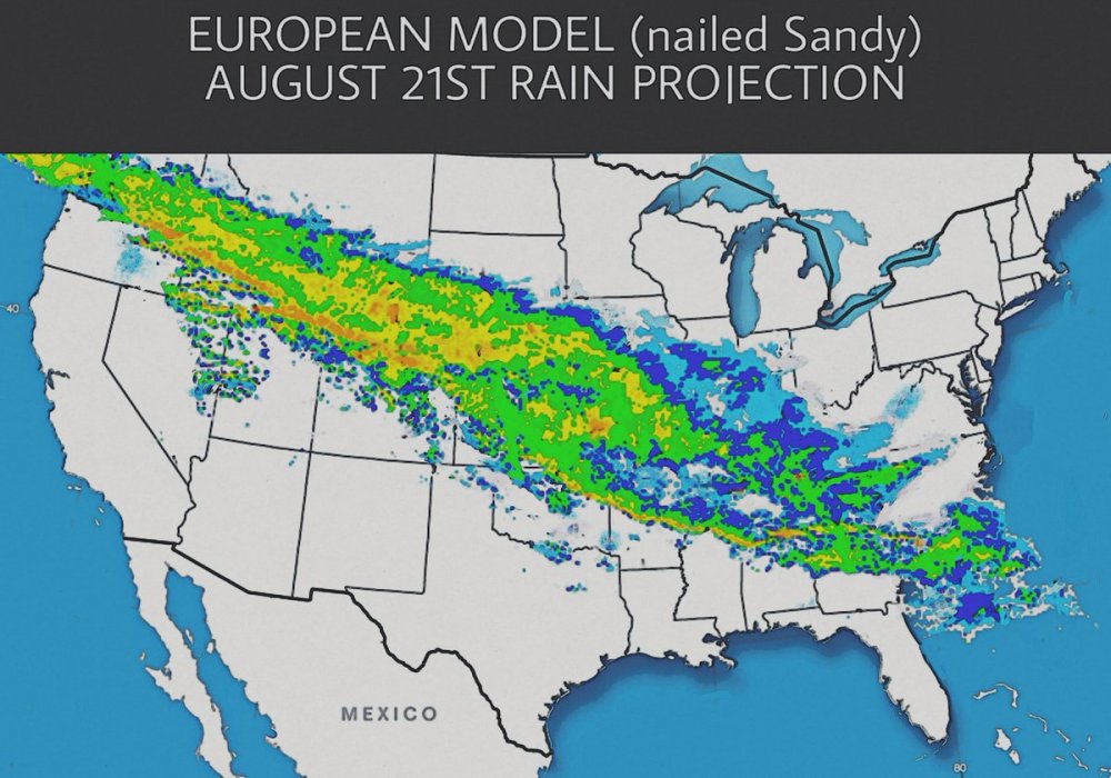
The nailed sandy part really got me though lol.
(EDIT: if this should be in the banter thread, feel free to put it there.)
-
1 hour ago, klw said:
this would seem to be an interesting run of the GFS

I've noticed there seems to be a problem with the GFS over-amplifying TCs lately. It was doing this last week too and has in the EPAC as well, although to a lesser extent. I'm pretty sure the GFS just had an update recently and this update brought a bit of an over-amplifying issue it seems. Either way, I wouldn't buy that, although decent strengthening is probable, just not to 870mb.
-
A strong June EML remains my biggest concern, although its really too far out to make this call, I really dont like that the past several GFS runs all have a very strong capping regime, so even if we do get excellent wind fields and solid CAPE, it may not matter. However, the main part of the trough is in Canada, which probably contributes at least a little to the whole plains being capped off. If the trough is able to slide south some and not eject so far north, I feel like eroding it should become much easier. This trough also has a huge area of 50kts+ 500mb flow, which is excellent for June, would be a shame to see it largely go to waste.

-
27 minutes ago, cyclone77 said:
For two runs in a row now the EC has a relatively decent setup over the eastern Dakotas/western MN for Friday. Hopefully it's on to something as the GFS is quite different. Decent mid-level flow arrives atop a plume of deep moisture/instability. Wind profiles look pretty respectable. Something to watch anyway.
In the EC's defense, the GFS verification scores are quite terrible lately. I saw a graph 2 or 3 days ago showing the scores, and the GFS is way(like significantly) lower than the Euro for the past week or so. I don't exactly know where to find it though.
-
1
-
-
1 hour ago, bjc0303 said:
12z ECMWF while somewhat north/west for Wednesday suggests a similar level of severe threat.
Friday looks weird. CAA regime really ****s with cyclogenesis.
That low up in near Sioux City is the key, that needs to lift north and/or be not nearly as strong with the CAA or else cyclogenesis will probably have a bit rougher of a time.
-
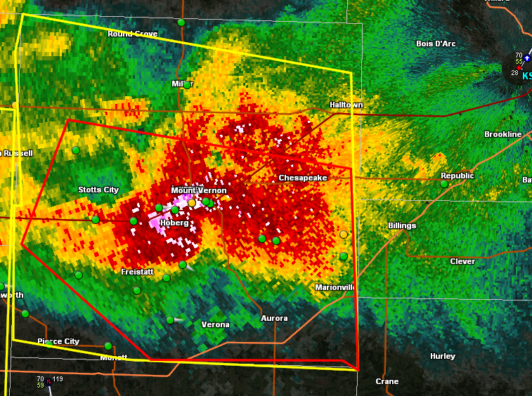
That is one mean HP supercell. Complete with a few idiots core punching(though GPS locations may be a few minutes behind I guess). At least tennis ball size hail in there I'd wager, based on CC values below 80% in places.
-
1 hour ago, Chinook said:
Typhoon Malakas at about the strongest point. The people of Taiwan must feel like a bad weather magnet recently. Typhoon Malakas maxed out at Cat 4, 115 kt at Sept. 16, 18z, reasonably close to Taiwan. Image is from Sept. 16, 2020z. Now it is moving toward southwestern Japan.

Is it just me or does the JTWC have a tendency to over estimate wind speeds. That doesn't look on par with a cat 4 due to a filled eye and no convection north of the center. Wasn't an issue on meranti before it entered the south China sea. Then I think they were over a little. I see lots of storms given ratings, that, based on satellite appearances do not look that steong. However I'm not familiar with the Dvorak classification or whatever thing they use to determine pressure and intensity.

Hurricane Maria
in Tropical Headquarters
Posted
Looking like the eye is already contracting due to land interaction with the mountains of Dominica. However, I'm not really surprised and expected this to happen since a pinhole eye is not stable, but can allow for more rapid intensification, which I mentioned this morning. I'll be interested to see what implications this has down the road. I would assume at the very least we will get a larger eye after this one is "replaced."