

hlcater
-
Posts
2,670 -
Joined
-
Last visited
Content Type
Profiles
Blogs
Forums
American Weather
Media Demo
Store
Gallery
Posts posted by hlcater
-
-
Live look at this storm, and the season as a whole

-
 2
2
-
 7
7
-
-
6 minutes ago, mannynyc said:
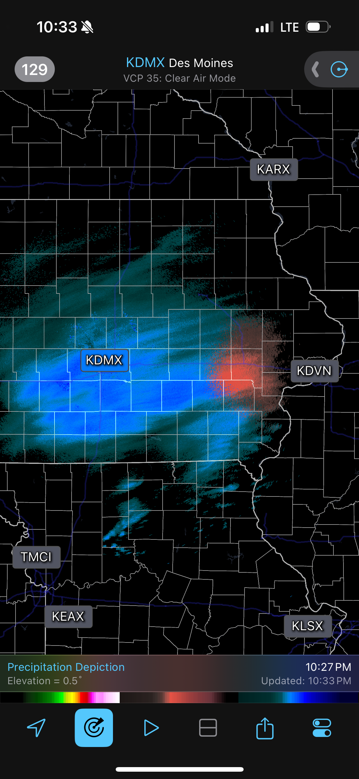
Radar looks pretty good for the appetizer in Iowa
Most of it is virga
-
No idea what to expect between the two waves out here. Range basically from nothing at all to 6"+ depending on which model you look at. No real trend one direction vs the other either
-
7.3" for the final total in IC
-
Sounds like dendrites/ratios where a big problem for a lot of people outside the primary axis of snowfall but out here we had good flakes for the majority of the day. I'll take measurements in a bit as snow continues to taper but I'd estimate at least 7-8" in Iowa City. The axis of heavier snowfall was a lot narrower than forecast of which the dry slot in IL is probably partly to blame, but elsewhere I gotta wonder if just poor lift/dry air in the DGZ causing ratios to not pan out the reason for underperforming.
-
 3
3
-
-
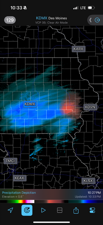
Snow has already begun in IC. Almost 6 hours ahead of schedule
-
4
-
-
DVN saying 7-10" out here on the point and click.
With temps in the teens, winds gusting to 25, and a mid day storm, you really cant draw up a better winter storm
-
1
-
-
Finally.
-
Real chance we go into february here with under 5" of seasonal snowfall and BA temp anomalies...
-
 2
2
-
-
3" on the nose today. More than tripling my season total coming into today in Iowa City
-
5
-
-
NAM at 84 tends to be north so not putting a ton of stock in that. As others have said, not really gonna put money in this coming north until there's a marked trend of this system doing so.
-
10 minutes ago, DocATL said:
Wrong threadI’m here to promote high quality discussion with fellow winter weather enthusiasts like me!!!!!
-
1
-
2
-
-
I just want to get pasted with the white stuff
-
 1
1
-
 1
1
-
 1
1
-
-
Yea that system tuesday could drop some cement out here if things trend right. NAM/Euro anecdotally have seemed to handle these setups pretty well in the past and they're the ones showing snow this time so I guess we'll see.
-
41 minutes ago, roardog said:
Those crazy abnormal heights in Canada are probably going to kind of act like a block which might keep it from getting too warm or cold. Days and days of low clouds and fog with easterly flow at the surface?
I think this is probably the most likely outcome. AA for sure but I’m not convinced that we get crazy anomalies
rainers for days tho
-
1
-
-
DAB+ out there to whiten things up
-
1
-
-
Comatose this far west so far and probably until at least Christmas
-
2
-
-
Yea this thing is in free fall again…
-
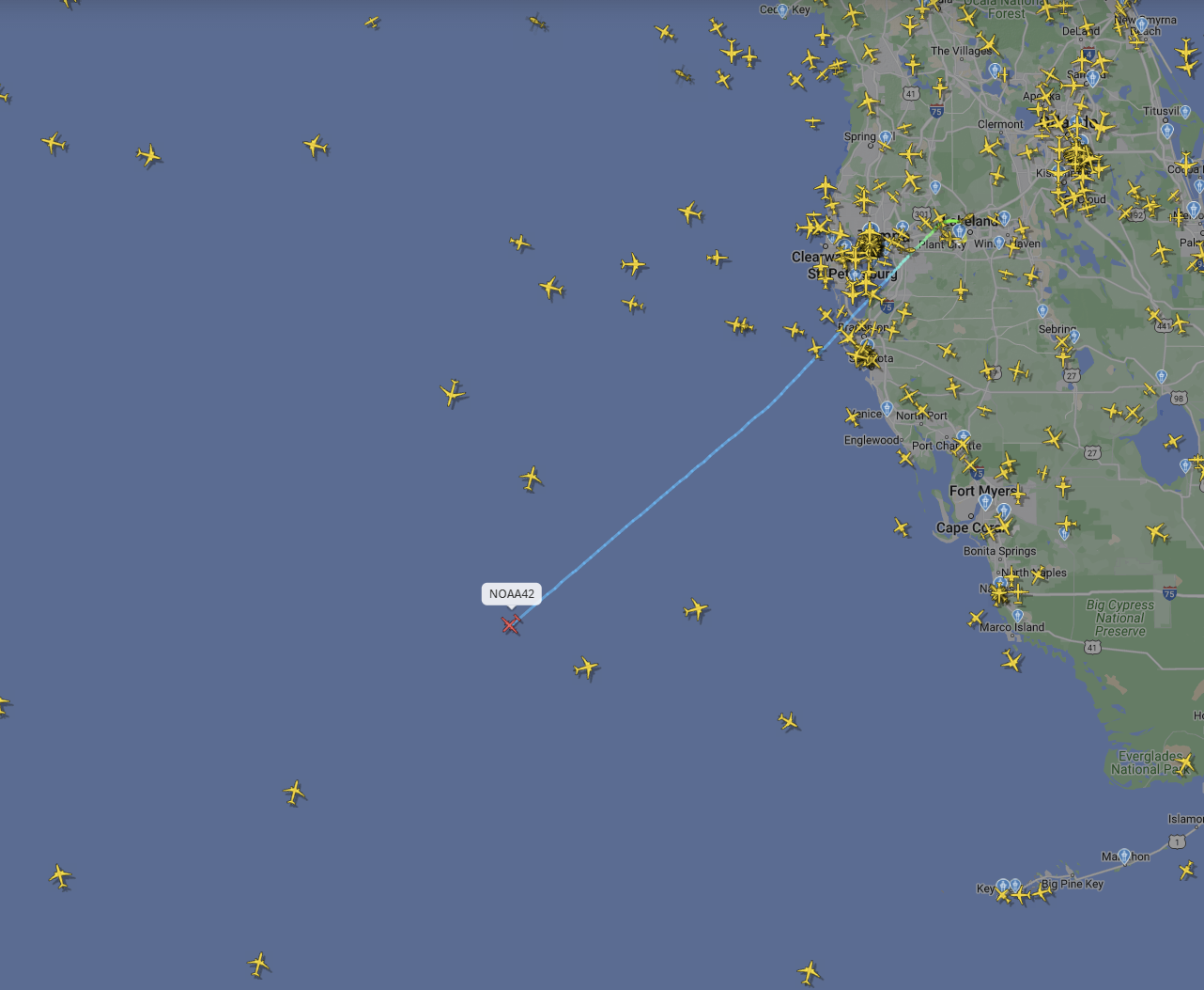
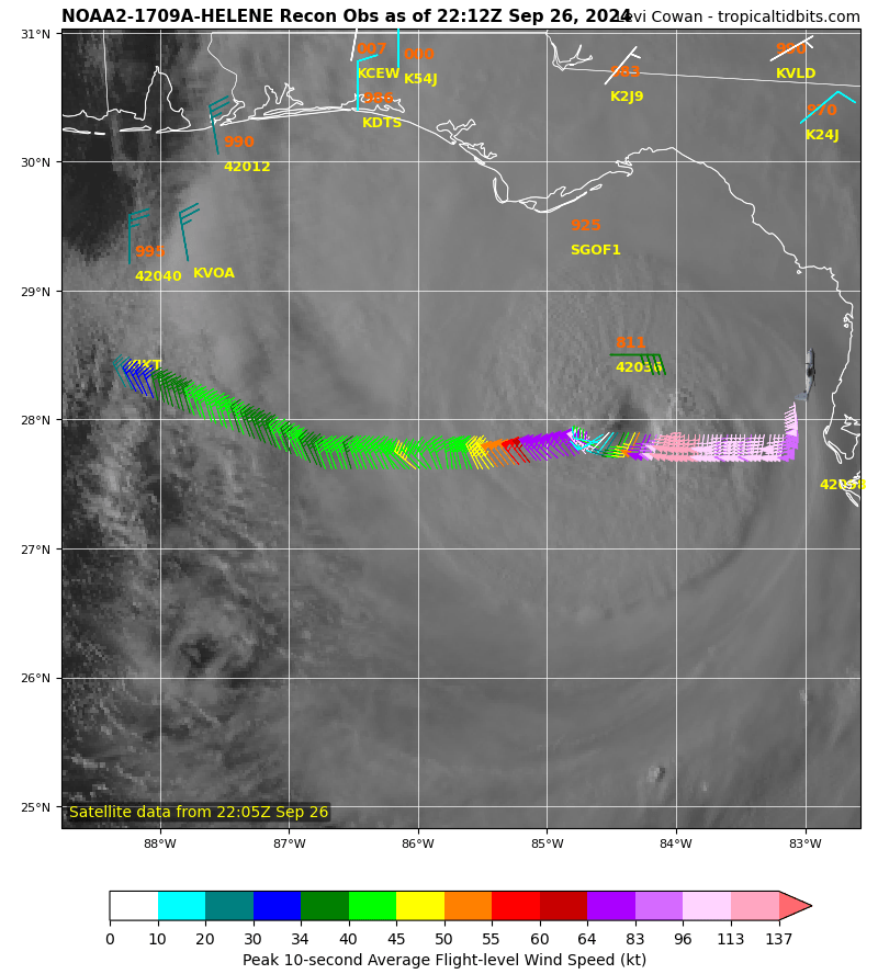
1 minute ago, StormChazer said:
Looks like the recon flight turned around?
Nope still straight as an arrow en route
-
1
-
-
6 minutes ago, Windspeed said:
^ This x1000. As has been reiterated over the years, TCHP/OHC and their related maps are important for gauging MPI, but they're based on 26° isotherm depth and do not quantify upper atmospheric dynamics and storm motion for intensities. A slow-moving hurricane with average upper dynamics are aided greatly by depth of the 26°C isotherm. But immediate or near-to-surface temperature for fast moving systems are sufficient for an intense hurricane to be avoid limitations of its own upwelling. Likewise, cooler than average upper tropospheric temperatures help to increase instability/atmospheric lift and lapse rates generated by slightly lower mean SSTs.
Simply put, 28-29°C shallow layer SSTs should be plenty enough octane for Milton to reach even Category 5 strength if its internal structure doesn't get in the way of itself. It will be moving too fast for upwelling to be an issue now. And even if you account for a lack of deep content just north of the Yucatán, atmospheric conditions should remain favorable as the hurricane is crossing the loop current. However, Milton should have peaked in intensity by then and most likely will already have completed its first EWRC.To this note I really think the only big thing that will limit Milton *is* shallow shelf waters as it passes near/south of scorpion reef.
-
5 minutes ago, cardinalland said:
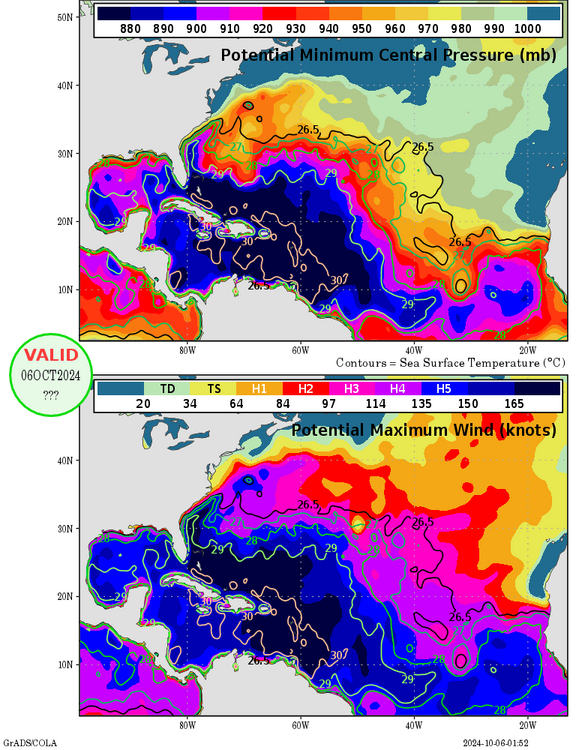
Keep in mind that core dynamics during RI and the atmospheric environment (ie atmospheric temps aloft) are also contributors to MPI, not just OHC.
-
1
-
 1
1
-
-

That look combined with NOAA43's radar scans earlier and 11nmi RMW.... ooof. Expecting substantial strengthening tonight. Could wake up to a major.
-
5
-
 1
1
-
-
6 minutes ago, wthrmn654 said:
My God, look at far east those crazy winds extend, not sure how much of that mixes down to surface but I hope people run for there lives if they haven't yet!
And to note, that is the buoy by the center, looks like it will go just east of it!

This is extremely important and worrying for surge. Massive hurricane force wind field combined with coastal geometry could easily yield 20+ft surge in spots.
-
1
-
1
-
-
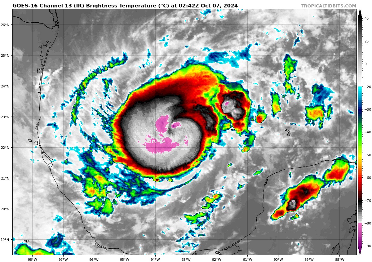
Was thinking it's either attenuation or subsidence caused by strong eyewall convection that caused the opening. Could even be both. In any case IR continues to improve on a rapid pace.
Should have recon data within the next 30 min.

March 2025 General Discussion
in Lakes/Ohio Valley
Posted
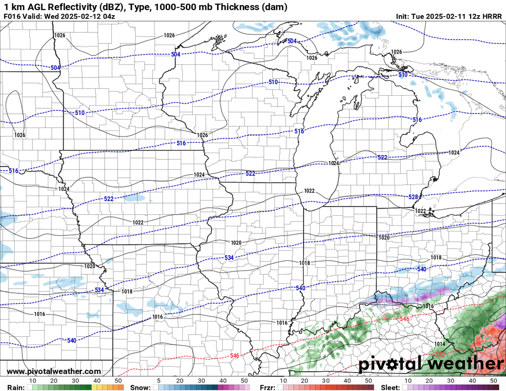
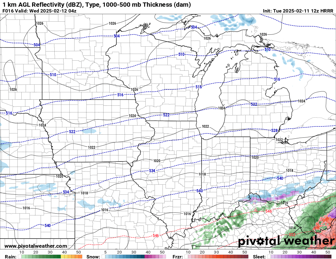
DVN was considering headlines last night but ended up deferring. 12z guidance so far showing a bit more eastward extension of accumulating snow than previous guidance cycles have. Think even 1-3" results in a high impact event when coupled with gusts of 55-60mph for several hours. Think WWA is the best fit currently but wouldn't be shocked with a game time blizzard warning if the 12z guidance is a bit closer to reality. Curious to see what they end up doing.
Doubly true when you consider that an increase in precip/snow rates will more effectively mix down that monster LLJ.