

hlcater
-
Posts
2,638 -
Joined
-
Last visited
Content Type
Profiles
Blogs
Forums
American Weather
Media Demo
Store
Gallery
Posts posted by hlcater
-
-
mix mix mix
-
So the HRRR has this massive mid level cloud deck yet still manages to mix out into the upper 50s. Nice model!

-
Too lazy to repost the pics so enjoy the tweet
-
 1
1
-
-
3 hours ago, purduewx80 said:
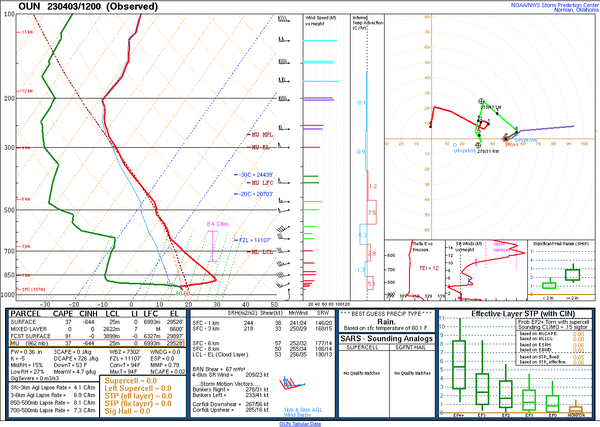
The deep layer of dry air that may cause LCL/capping/moisture issues is clearly evident on 12Z soundings over the Plains this morning, where Gulf return moisture looks great at first glance.
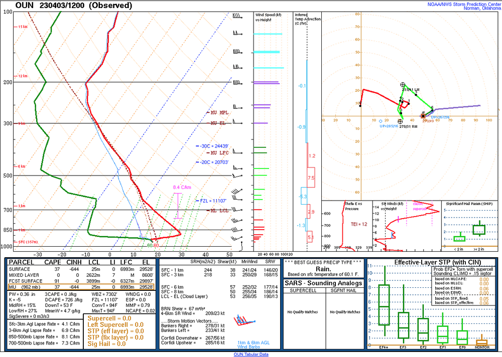
The one thing making me feel better about that is that it was forecast.

-
Concerned that the trough is too slow to eject and the prospect that the EML does not fully erode during daylight.
-
2
-
-
23 minutes ago, WxSynopsisDavid said:
Dude, absolutely impressive. You and every other chaser out there did great on the pictures and videos. I would love to witness/experience twin tornadoes.
It’s not hard when the storm is easily S tier and probably the best Iowa supercell since 4/9/11. Pella comes close but as someone who was at both, this beat Pella.
Will obviously need to wait for the rest of the year but I expect Keota in particular to be a serious TOTY contender.
-
2
-
-
21 hours ago, CheeselandSkies said:
Uploaded an unlisted quick cut to my YouTube channel. Now off to bed.
Also this video is totally nuts
-
1
-
-
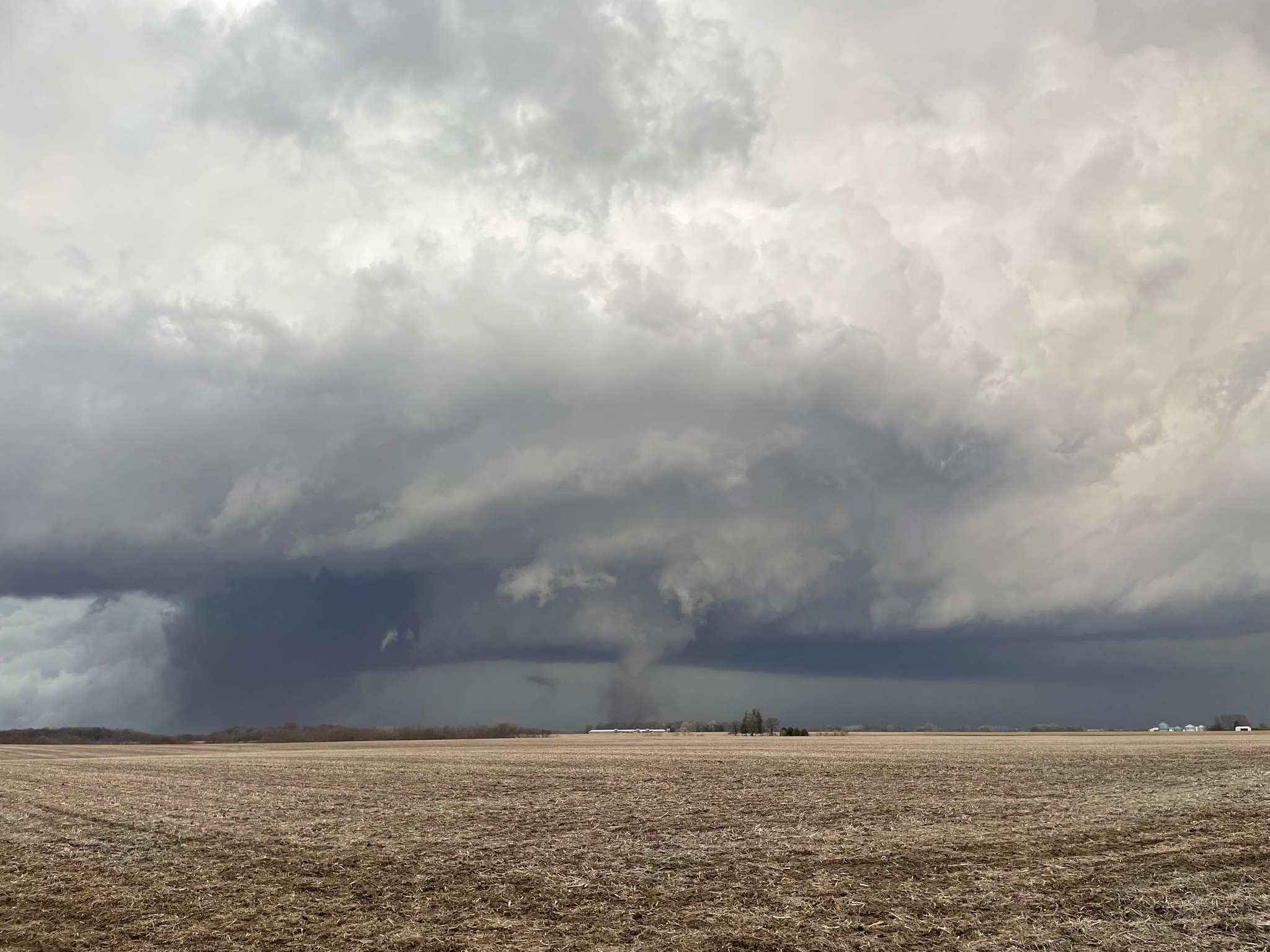
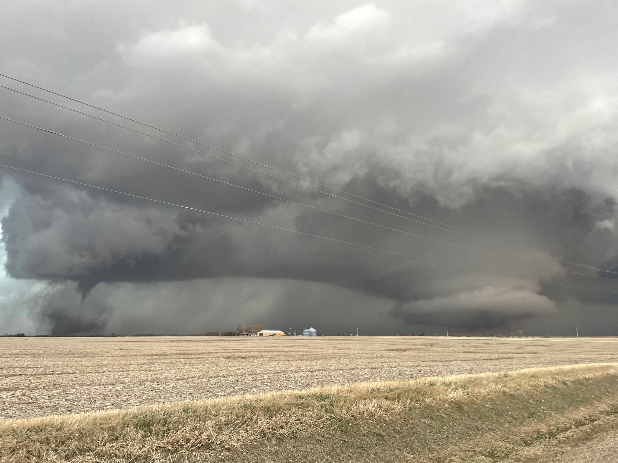
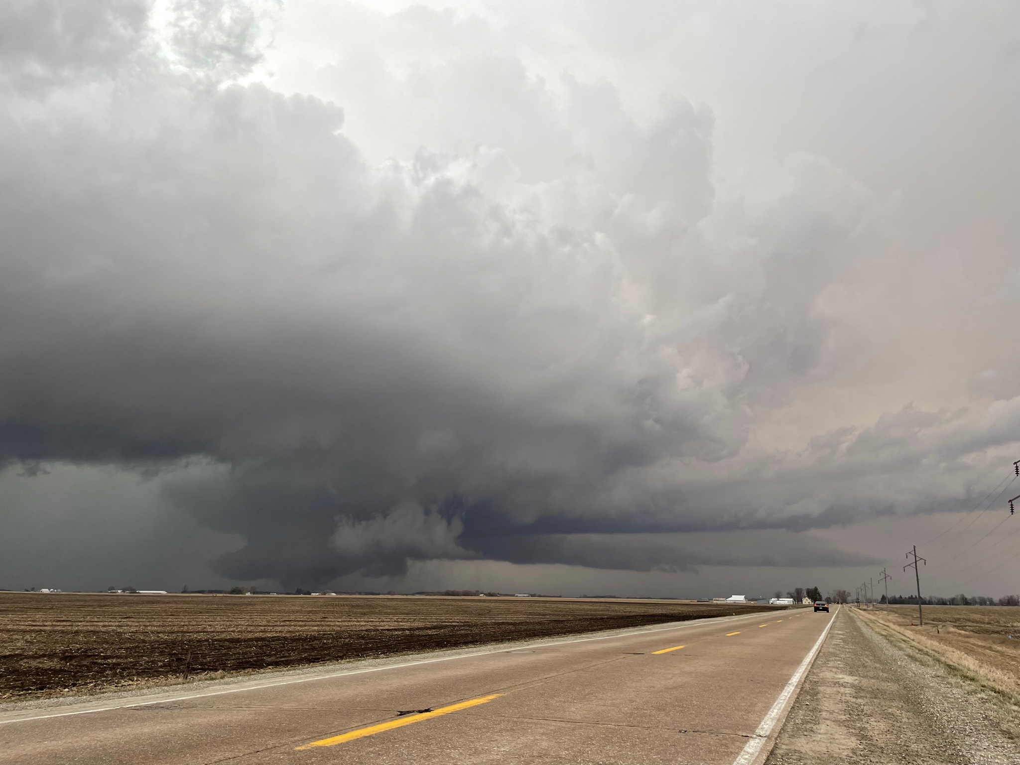
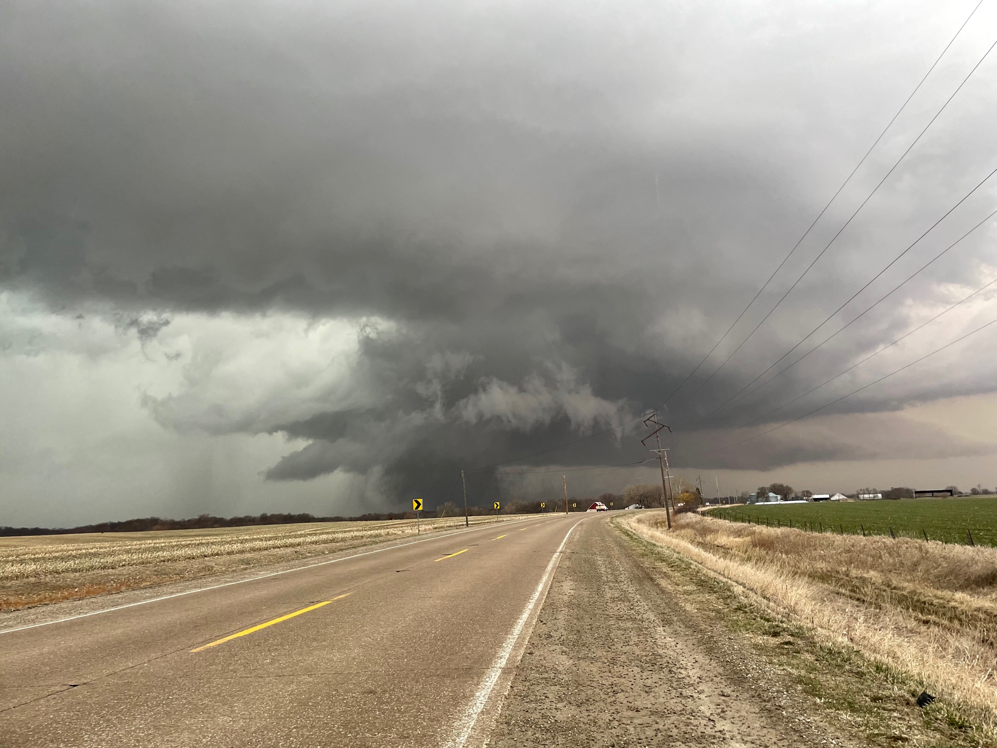
A bit late, but I worked at 11pm last night and again at 3pm today so my whole "post chase" process is a bit delayed. Don't have much to add off of what has already been posted but I started the day in Mt. Pleasant and planned to just kinda wait and play the field with the developing supercells. The wave in the morning was still a bit stable and while they were supercellular aloft, they were not surface based so I did not follow them east. I drove to fairfield to wait for the storms to the south and west to mature and ultimately chose the storm that would track near Ottumwa as it was obvious on radar/vis that it was the dominant storm. Perhaps due to some Winterset PTSD, I chose to stay miles and miles ahead of the storm and instead of close intercepts, planned my routes with keeping up in mind. Still, these were some of the most visually impressive tornadoes I have seen. Especially the Keota EF4.

Hendrick tornado while it was in full swing from miles away.
Handoff near Keota.
The Keota tornado about as it was doing EF4 damage. This may be my favorite shot I've ever taken.
Again as it was approaching Wellman. Big dusty wedge for most of its life. For those familiar with 2/28/17, think of it as Washburn on steroids.
-
8
-
-
7 hours ago, A-L-E-K said:
Extended looks good, this is our year
I'll take a blend of April 1974 and April 1965
-
2
-
 4
4
-
-
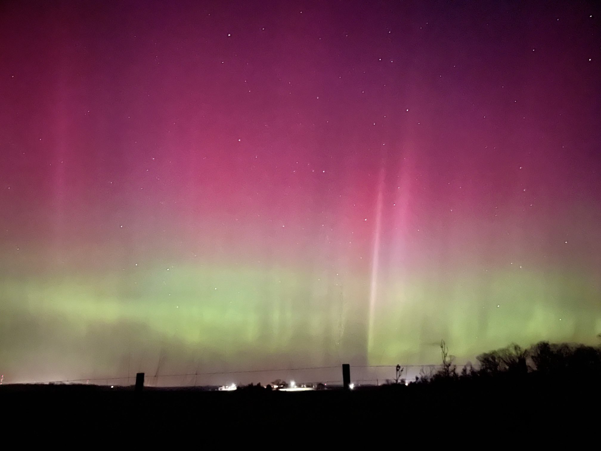
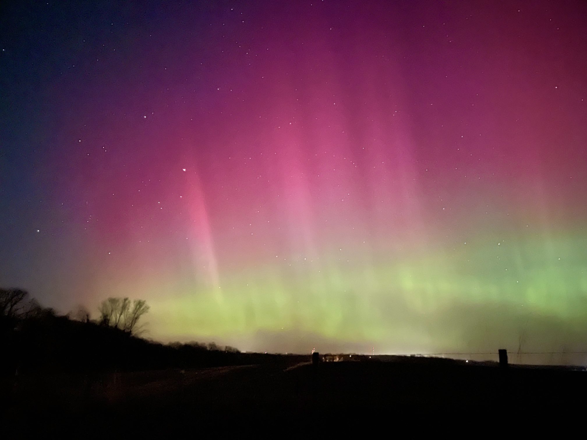
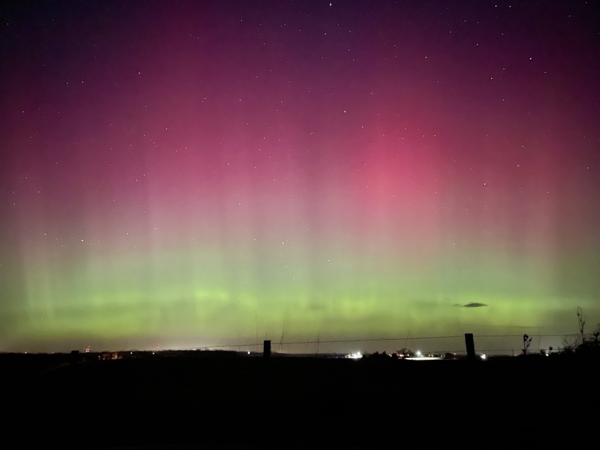
A few days late but here are some phone shots of the northern lights last thursday. First time seeing them so I wasn't really prepared.
-
9
-
-
We are gonna limp our way to seasonal average on these cement events. Measured 4.0” today. Though snow residence time has to be well below normal as every event this winter has had marginal temps during and afterward, so nothing hangs around more than a few days
-
1
-
-
5 hours ago, A-L-E-K said:
rainer
Eurythmics szn
-
Euro is kind of an outlier even among the ensembles.
The trend in Texas over the past few days has been to unanimously slow this thing down which should bode for a more NWly track but we’ll see.
-
This is likely to be the best storm of the season here despite the 3-4 hr dry period. The defo zone quickly made up for that and with 1-2 hours of snow left, will likely finish with 6-7". About in line with the model consensus. Nice to break the trend of events falling short of expectations this winter.
-
2
-
-
On pace to see 6”. Pleasantly surprised
-
2
-
-
Think my call is gonna be 3". Been riding the low end of guidance this winter, with the best forcing looking to translate just south of MBY seeing no reason to do differently in this instance.
-
2
-
-
At this point let's get a 6" storm or move on to spring. Sick of these 1" snows.
-
2
-
-
Looking like another broom snow for those south of 20. lol.
-
NAM is going wayyyyyyy north
-
Omaha/Lincoln are in a very special place right now
-
I’ll consider it a W if we can reach 3”.
-
Really liking the R/S line setting up 10 miles NW of here.
-
-
14 hours ago, hawkeye_wx said:
My December snow total is up to 7.4" and my season total is 10.1". Both are close to average.
Gonna be tough to get an average January seeing as it looks likely that we will struggle for substantial snow for the first week, if not more.
Severe Weather 4-4-23 and 4-5-23
in Lakes/Ohio Valley
Posted
Went out and saw quite literally nothing. Screwed by the Ft. Madison bridge crossing and not willing to core the baseball sized hail necessary to get ahead of the storm, just gave up and went home.