

hlcater
-
Posts
2,638 -
Joined
-
Last visited
Content Type
Profiles
Blogs
Forums
American Weather
Media Demo
Store
Gallery
Posts posted by hlcater
-
-
6 minutes ago, Nibor said:
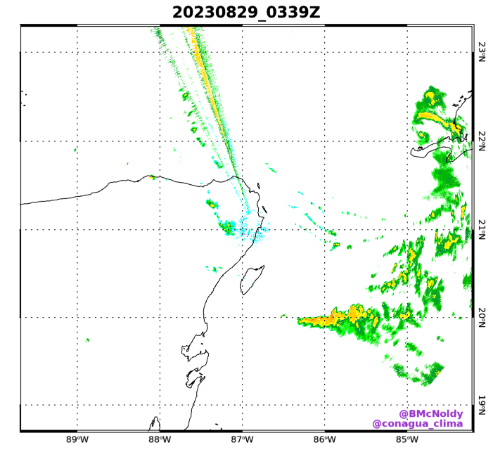
A little hard to tell but it looks like circulation will come very close or over Cozumel.
The thing here is that the circulation is small enough and the current convective intensity is low enough that if a large MCS were to fire to the east, either the current center would be pulled east toward it, or a new center could form.
-
 8
8
-
-
4 minutes ago, WxWatcher007 said:
Gert may have been on their mind


The reply guys on Twitter really got to them
-
-
This is 2-3 days ahead of schedule in the Yucatán channel. As it meanders in a low shear environment what I’ll be watching for is if and how quickly a solid CDO/inner core develops. If we can get one going prior to shear increasing in 2-3 days, then the ceiling for this is much higher.
-
Don’t feel confident enough to commit to a major hurricane until we get a better idea of what shear will look like as this transits the gulf. With a very dry continental airmass lurking just west of the storm impacts of any shear could be exacerbated
-
3
-
-
2 hours ago, Kevin Reilly said:
Everything has a late season feel to it up here. The weather up here in the northern Mid-Atlantic and Northeast has been nothing resembling August. The trees up here have been changing colors now for weeks and it is not drought related. We have only touched 90 degrees twice the entire month. Honestly there has been a NW, N, or NNE, NE flow up here since basically the fronts have never stopped coming. It should be really interesting to see what happens September to March.
Someone has not looked at a 500mb map for at least the last 10 days and it shows
-
1
-
-
As the GFS now develops this system and there is 70% odds of development in the next 7 days, it's probably time for a thread on this one. It also doesn't look like the low is defined enough yet in the W carib to be designated as an invest, but when it presumably does, it'll be 93L.

-
1
-
-
43 minutes ago, LongBeachSurfFreak said:
Incredible! Watching an eyeball form live on radar. Probably a decent but stronger than the estimated 50mph 998 official landfall. Probably more like 65mph 992.
nah
-
Looking closed on visible now
-
4 minutes ago, CheeselandSkies said:
Wasn't this seen with the (unexpectedly disrupted, I was sure it was going full Wilma) bomb-out of Hurricane Delta in 2020?
Maybe, but you also need just a little bit of shear and disorganization to get a singular updraft to be sufficiently strong to do that.
-
5
-
-
This is pretty neat
-
2
-
-
17 minutes ago, WxWatcher007 said:
Whew, this latest set of obs from recon is interesting. We'll see if it's enough for the NHC.
1000.4mb (extrapolated at ~1,300ft) with a pretty sharp wind shift.
Peak FL wind obs between 45-50kt with peak SFMR obs between 45-56kts, none rain contaminated.

Lol I was about to come in here and say you could make an argument for classifying this based on vis. I didn't know recon is in there. Clearly a closed low on the eastern side of the convective shield.
Also with the minimum extrap of 1000.5. Very nice little low in there.
-
3
-
-
12 hours ago, WxWatcher007 said:
Nice analysis here. Think of all the waves, the one with the best odds of being notable long term is the AEW just now leaving Africa. I think 90L develops into a TD/TS over the next day or so but dry air and westerly shear courtesy of the TUTT should keep a lid on that one. There is a chance that it stays disorganized and slides far enough south to avoid getting picked up and drawn northward, but the vigor of the wave currently kinda argues against that. Would expect it to be pulled up into the western atlantic with perhaps a rainfall threat in Hispaniola as it does so.
-
1
-
-
4 minutes ago, WxWatcher007 said:
Hurricane Hilary Discussion Number  11
NWS National Hurricane Center Miami FL       EP092023
900 PM MDT Fri Aug 18 2023

Hilary's cloud pattern has not changed much since earlier today.
The hurricane continues to exhibit a large 30-35 n mi wide eye with
a surrounding ring of deep convection with clouds tops around -75
degrees Celsius. The latest subjective Dvorak intensity estimates
from TAFB and SAB support an initial intensity of 115 kt. The next
Air Force Reserve reconnaissance mission is currently en route, and
it should provide a better assessment of Hilary's intensity and
structure overnight.

Hilary has turned north-northwestward with an initial motion
estimate of 335/12 kt. The track forecast reasoning is unchanged
from before.  Hilary is forecast to turn northward and begin to
accelerate on Saturday as it is steered by deep-layer southerly flow
between a strong subtropical ridge over the south-central United
States and an upper-level low off the coast of central California.
The models have again trended slightly faster, and the NHC foreast
has been adjusted accordingly.  The NHC track forecast brings the
center near the west-central coast of the Baja California Peninsula
in about 36 hours, and along the northwestern coast of the peninsula
in 48 hours.  This is near the middle of the tightly clustered
guidance envelope.  Users are reminded to not focus on the exact
details of the track forecast as strong winds and heavy rainfall
will extend far from the center.  These hazards will begin well in
advance of the arrival of the center.

Hilary has likely peaked in intensity, and weakening is expected to
begin on Saturday as it moves over cooler SSTs.  A faster rate of
weakening is likely to begin by 24 hours as Hilary moves over
SSTs less than 26C and the vertical wind shear begins to increase.
However, Hilary is forecast to be a large hurricane when it passes
near the west-central coast of the Baja Peninsula, and a
tropical storm when it nears the U.S./Mexico border.  The NHC
intensity forecast is similar to the previous advisory, and lies
close to the IVCN consensus model.

KEY MESSAGES:

1. Heavy rainfall associated with Hilary will begin well in advance
of the center, from the Baja California Peninsula into the
Southwestern United States. Preparations for the impacts of flooding
from rainfall should be completed as soon as possible, as heavy rain
will increase ahead of the center on Saturday. In the Southwestern
United States, flash, urban, and arroyo flooding is expected, with
dangerous and locally catastrophic impacts likely.

2. Hurricane conditions are expected within portions of the
hurricane warning area along the west-central coast of the Baja
California Peninsula Saturday night and are possible in the
Hurricane Watch area.

3. Tropical storm conditions are expected to begin on Sunday in
portions of southern California where a Tropical Storm Warning is in
effect.

4. Large swells generated by Hilary will affect portions of the
coast of southwestern Mexico, the Baja California peninsula, and
southern California over the next few days. These swells are likely
to cause life-threatening surf and rip current conditions.


FORECAST POSITIONS AND MAX WINDS

INIT  19/0300Z 19.7N 112.7W  115 KT 130 MPH
 12H  19/1200Z 21.4N 113.6W  110 KT 125 MPH
 24H  20/0000Z 24.2N 114.4W   95 KT 110 MPH
 36H  20/1200Z 27.6N 115.4W   80 KT  90 MPH
 48H  21/0000Z 32.1N 116.8W   55 KT  65 MPH...INLAND
 60H  21/1200Z 37.8N 117.8W   30 KT  35 MPH...POST-TROP/INLAND
 72H  22/0000Z...DISSIPATED

$$
Forecaster Brown
With the way things are going on satellite, I am not convinced that we have peaked in intensity. Think we make another run at 125-130kts tonight. Recon will tell.
-
5
-
-
Not in the cooler waters yet. Probably by tomorrow AM though.

-
1
-
 1
1
-
-
We'll also have recon tomorrow.
Quote000 NOUS42 KNHC 171455 REPRPD WEATHER RECONNAISSANCE FLIGHTS CARCAH, NATIONAL HURRICANE CENTER, MIAMI, FL. 1055 AM EDT THU 17 AUGUST 2023 SUBJECT: TROPICAL CYCLONE PLAN OF THE DAY (TCPOD) VALID 18/1100Z TO 19/1100Z AUGUST 2023 TCPOD NUMBER.....23-079 I. ATLANTIC REQUIREMENTS 1. NEGATIVE RECONNAISSANCE REQUIREMENTS. 2. OUTLOOK FOR SUCCEEDING DAY.....NEGATIVE. II. PACIFIC REQUIREMENTS 1. HURRICANE HILARY FLIGHT ONE - TEAL 77 FLIGHT TWO - TEAL 78 A. 18/1730Z A. 19/0530Z B. AFXXX 0109E HILARY B. AFXXX 0209E HILARY C. 18/1215Z C. 19/0015Z D. 18.5N 112.1W D. 20.3N 113.3W E. 18/1700Z TO 18/2030Z E. 19/0500Z TO 19/0830Z F. SFC TO 10,000 FT F. SFC TO 10,000 FT G. FIX G. FIX 2. OUTLOOK FOR SUCCEEDING DAY: CONTINUE 12-HOURLY FIXES. BEGIN 6-HOURLY FIXES AT 20/1130Z. $$ WJM/SET NNNN-
1
-
-
Classic deep tropical cane right now with the rapidly cooling CDO and expansive spiral banding in all quadrants. Feel like the ceiling is pretty high over the next 24-36 hours.
-
5
-
-
Hodographs are rather small and lacking changes in speed/direction above 2km or so. But of course these are were pulled off globals and subject to change once higher res guidance gets in range.
-
1
-
-
9 hours ago, hlcater said:
Someone is gonna pay for this. Exceptional thermos, adequate shear and a favorably oriented boundary suggesting an outside shot at a higher end MCS later today. Anecdotally, giant CAPE combined with very steep LLLRs (8.5-9.0) usually seems to correlate with strong downdraft potential. Additionally, with hodographs favorable for supercell development and LRs >7.5 throughout the column, would expect a large hail risk in the first 1-2 hours before upscale growth takes hold.
One caveat could be the complete absence of a LLJ casting doubt in MCS maintenance potential, but that's something that's always confused me a little bit. There's no doubt a strong and coherent LLJ helps MCS maintenance/intensity, but how badly does an absent LLJ hurt? There are some very notable MCS cases that had zero LLJ to speak of.

Money money
-
1
-
1
-
-
Someone is gonna pay for this. Exceptional thermos, adequate shear and a favorably oriented boundary suggesting an outside shot at a higher end MCS later today. Anecdotally, giant CAPE combined with very steep LLLRs (8.5-9.0) usually seems to correlate with strong downdraft potential. Additionally, with hodographs favorable for supercell development and LRs >7.5 throughout the column, would expect a large hail risk in the first 1-2 hours before upscale growth takes hold.
One caveat could be the complete absence of a LLJ casting doubt in MCS maintenance potential, but that's something that's always confused me a little bit. There's no doubt a strong and coherent LLJ helps MCS maintenance/intensity, but how badly does an absent LLJ hurt? There are some very notable MCS cases that had zero LLJ to speak of.
-
7
-
-
Really liking how tonight's precip odds have.... quite literally.... evaporated.

-
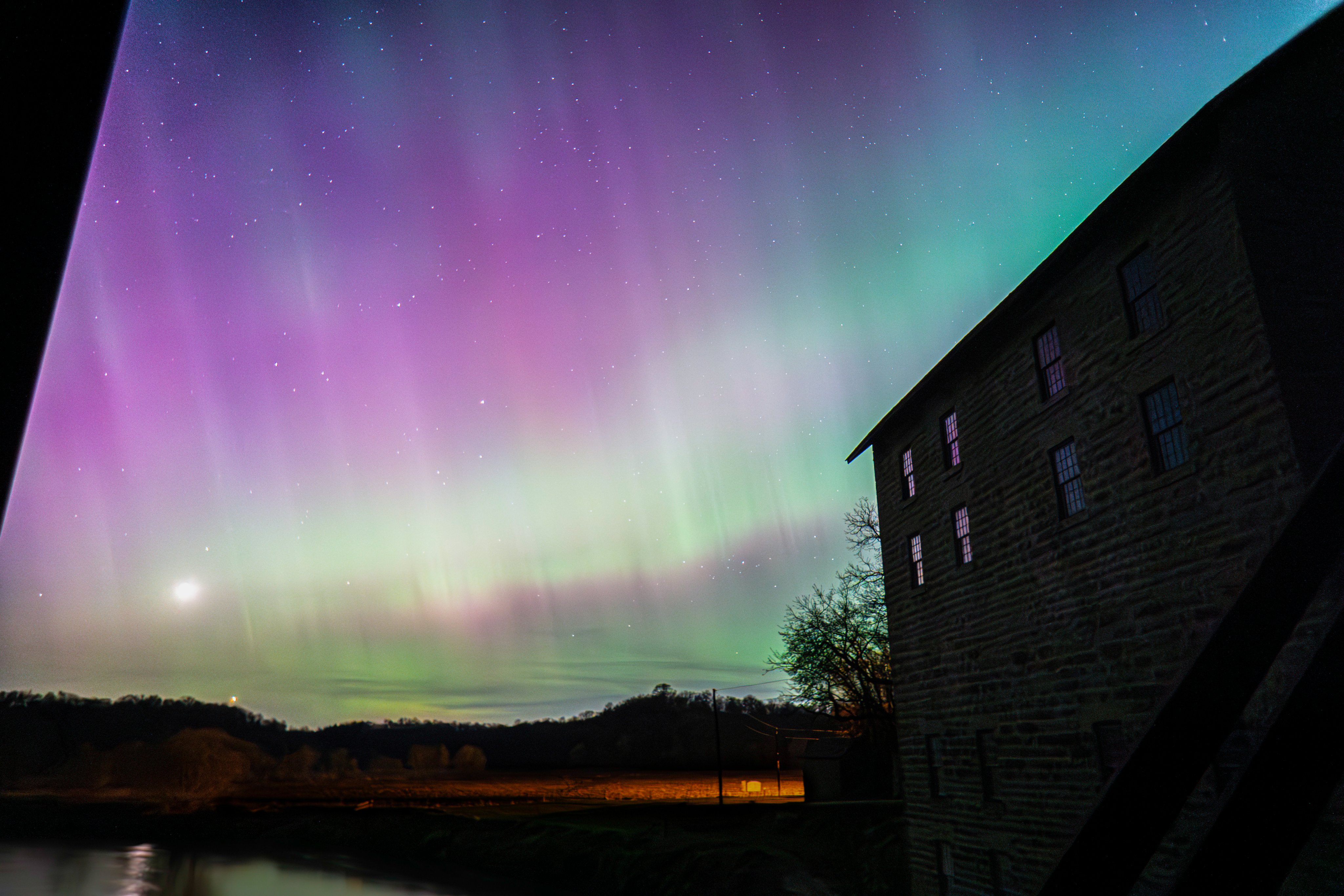
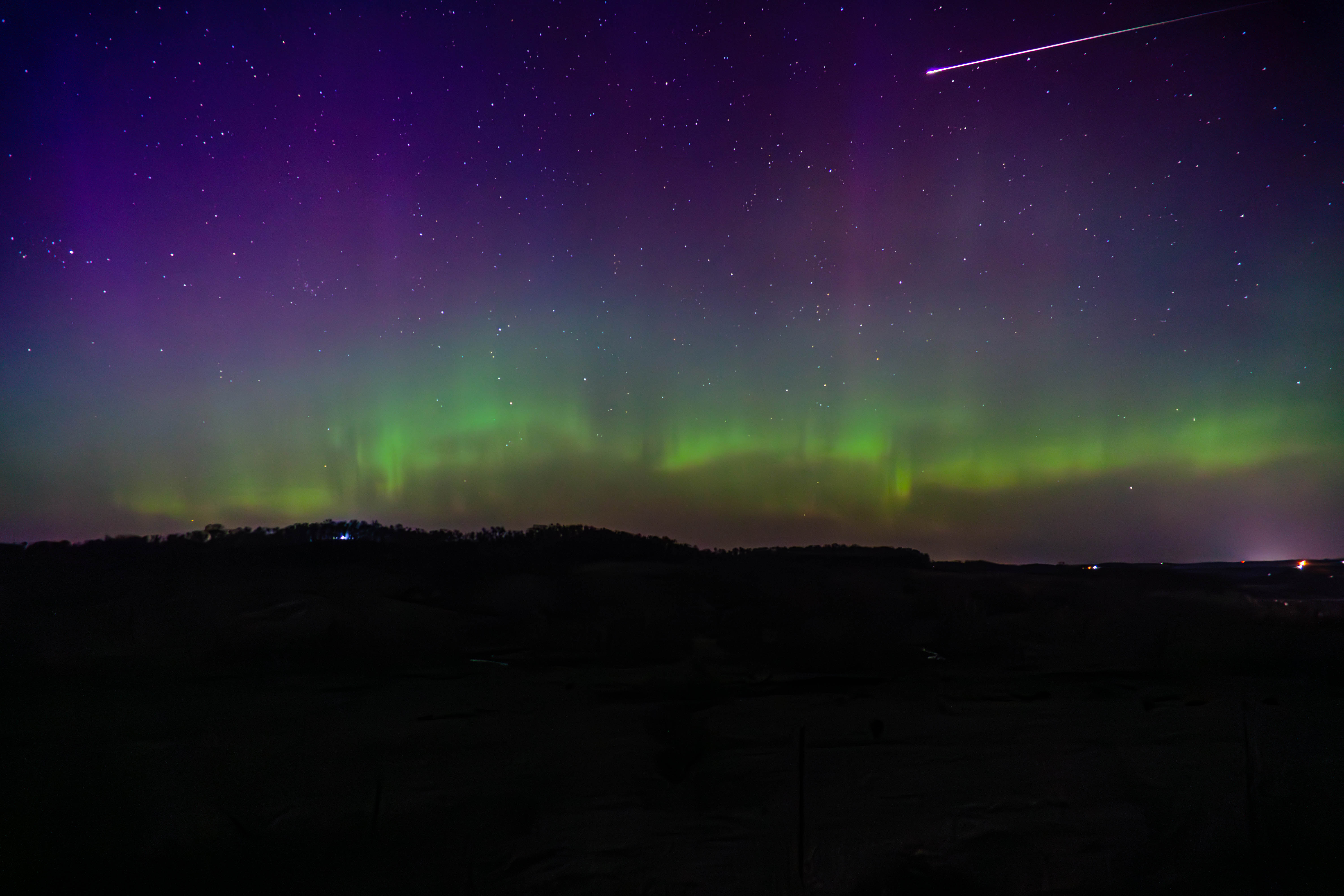
Late to the party, but here's what I came away with from Sunday's aurora. After seeing them for the first time somewhat haphazardly on 3/23, I put some more thought into it this time.

-
20
-
2
-
-
7 hours ago, cyclone77 said:
Thursday system looks pretty interesting. A strong warm front is gonna bisect the DVN/LOT cwas. Looks like one of those days where it'll be stuck in the 40s at Dubuque all day, while southeast IA basks in the tropical 70s with a severe threat. SPC (Broyles lol) has a risk way south in southern MO/AR, but will likely need to be expanded much further north in later outlooks.
The biggest issue with 4/19 and 4/20 is wave timing. The primary wave is a bit too far west on 4/19, which would still be workable in W IA, but most models have a shortwave traverse the area the morning of 4/19 which veers the LLJ off to the east with it. That leaves us with 4/20 which has the primary wave ejecting, but probably a bit too quickly to maximize the risk. The Euro's solution is almost good, with primed soundings at 18z across SE IA and W IL, but the wind fields again veer out later in the day and a strongly forced cold front surges east as the wave closes off aloft, doesn't exactly scream visible tornadoes to me. Could see either one of these trending into a somewhat decent local day, but it's difficult to say which one is the better of the two at the moment.
-
1
-
-
On 4/5/2023 at 2:41 PM, Malacka11 said:
Here are two videos from yesterday. First one is of the supercell itself and the second is from inside the tornado. I'd like to apologize in advance for not only using phones, but also recording in vertical format. Didn't have time to pull the DSLR out unfortunately for good shots of the storm, and obviously I'm just happy to have any footage from inside the tornado at all.
Oh yeah, and please excuse my language in the second video. Hard to stay PG when you think you're about to get maimed. Looking back I didn't even duck down, idk what I was thinking.
https://youtube.com/shorts/d5M407cuge4?
feature=sharehttps://youtube.com/shorts/fRWcBVP-nUA?feature=share
Again, apologies for the excessively amateur impression I'm making here.
Dude be careful out there. Losing situational awareness can total your car or worse. Other chasers were also hit by tornadoes from this storm and fared far worse than you did.
Despite what some may say, 0 metering is not worth it in most cases. Oftentimes the 100-250 meter shot is better anyways
-
2
-


September 2023 General Discussion
in Lakes/Ohio Valley
Posted
Heat or not the first half of september is looking majorly dry. Dry enough that some areas could see their first ever occurrence of D4 conditions if something doesn't change my mid-late month.
River levels in eastern Iowa have eclipsed 2012 and there's little reason to be optimistic.
Summer currently polling at a solid F- for me.