

hlcater
-
Posts
2,638 -
Joined
-
Last visited
Content Type
Profiles
Blogs
Forums
American Weather
Media Demo
Store
Gallery
Posts posted by hlcater
-
-
I need warmth. Absolutely sick of snow.
-
 1
1
-
-
Oh yeah, this right here is just great. Actually this is EXACTLY what I want to see. This trough just decides that it needs to park itself over the eastern conus, because why on earth would we want southern flow anywhere in the central US?

Too add on to this, Massachusetts has higher dews than the YUCATAN PENINSULA.
-
 1
1
-
-
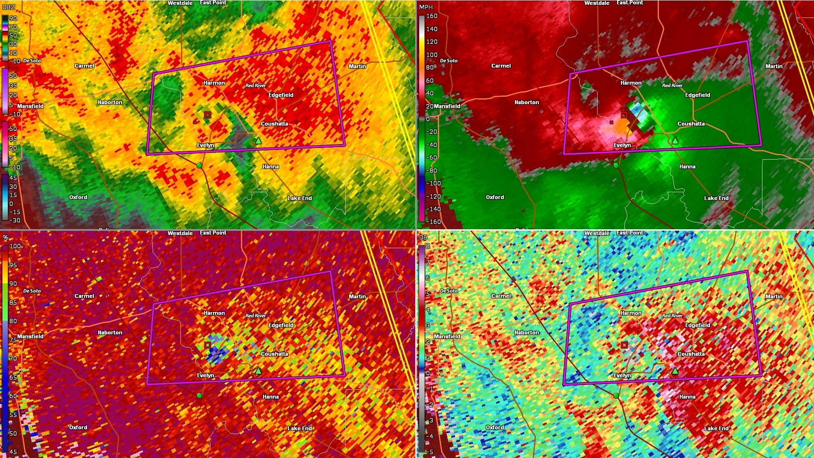
Tornado EMERGENCY in Louisiana for this nasty tornado right here. That thing is meeaannnn.
-
44 minutes ago, Hoosier said:
12z GFS bottoms out the surface low around 972 mb. That is about as deep of a surface low as you can get at that latitude at this time of year.
Occluding low doesn't lend itself to a tornado threat real well. But these systems almost always have a strongly forced line/QLCS along the cold/occluded front in that narrow axis of instability. At this time, I'm more interested in areas further south. But I guess we can hope the trough deamplifies someand the surface low doesn't occlude as fast can't we
") . Should the surface low not occlude(which I think is unlikely for our area), a more significant event could be in the cards.
. Should the surface low not occlude(which I think is unlikely for our area), a more significant event could be in the cards.
-
28 minutes ago, CheeselandSkies said:
Quincy is not impressed. Neither is Jeff.
https://stormtrack.org/community/threads/2018-severe-wx-chase-season-discussion.29986/page-3
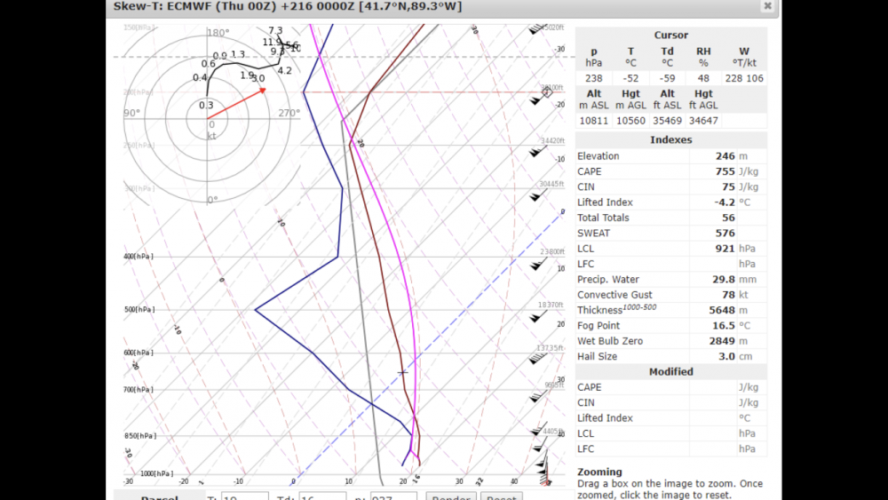
You’re gonna need a 60% hatched to impress Jeff nowadays, meanwhile here is a sounding off the euro.(I found it so don’t expect any more) It’s near sterling, IL
-
This current storm is gonna push this winter into solid B territory. Despite the no snow first 3 weeks of December, we had a nice run from Christmas eve followed by record cold during early January. Then the second half of January largely failed to show up until the amazing early February stretch that pretty much carried this winter. Snow every day for a week straight was unusual here and it was awesome. This would have been a C- winter by itself. Then we the storm we just got was fantastic. 2 hours of thundersnow, followed by a nice steady moderate day time snow for a total either side of 9". This winter is odd in the sense that nearly all of our snow here came during 3 periods with sizable lulls of nothing in between.
-
2
-
-
Can we please ditch the -NAO?
-
1
-
-
1 hour ago, jaxjagman said:
The last run of the GFS shows some better capes,even over 1k in Mid Tn Monday afternoon.If you want to believe the NAM it shows capes of around 3k and a PDS around Nashville
I think the NAM is suffering from convective feedback, especially across TN. Therefore I’d probably take its output with a grain of salt.
-
1
-
-
ERTAF(fwiw, which I think it’s actually pretty good) has that period marked for above average tornado activity as well.
-
1 hour ago, Stebo said:
Last year wasn't a good chase season for a multitude of reasons including lack of intense tornadoes. It is pretty widely regarded in that respect that the year wasn't great.
Also because the tornadoes themselves were pretty much all rain wrapped farts that lasted 2 minutes before getting inflow chopped by another storm, because many of the days last year featured way too many storms, like the opposite of cap busting. I hope to God we can at least beat the quality of the tornadoes last year.
Anyway my guess for this year:
1275 tornadoes
First high risk: March 13th in AR/LA/MS
-
1
-
-
2 hours ago, WhiteoutWX said:
Love his EF+/- forecasts on severe days. Those are *super* helpful
While I think the chances of snow on or near Christmas are greater than average this year...to make an 11 day forecast with hourly timing is absolutely absurd and dishonest as to the current capabilities of the field of meteorology.
Pretty sure you summed up mike morgan as a whole right there.
-
You guys are getting (measurable)snow before we are IN IOWA! I highly doubt that's ever happened before.
-
3
-
-
41 minutes ago, WhiteoutWX said:
Probably the best GFS run I’ve seen for this part of the country. Keeps the trough more towards the center of the country, retrogrades to our west by the end of the run with continued ridging into Alaska/western Canada to continue funneling cold air. Models have been bouncing around a lot with the post 7 day period so we will see if it lasts...
Bouncing around with the rough placement of this body of cold air. But they all have been remarkably consistent in having this cold air present and have been hinting at storm potential somewhere, but that's where the consistency ends. I'm just happy that we've got a solid mass of seemingly persistent cold air for systems to feed on. Obviously better if the main body of cold air is further west, like you mentioned, but as long as its cold without dry northwest flow, I'll take it. But I do expect the cold(maybe stormy?) look to last, maybe even for those further south.
-
Coming to a May 2018 near you!

-
4 minutes ago, cmasty1978 said:
What is 3 then if not Maria?
Gonna have to go with Patricia and Haiyan as my guesses if Maria is numero 3. If not, maybe dujuan(I think that's the name) in 3rd?
-
That storm is sitting on an area of 500+ eSRH not surprised there's reports of a large tornado.
-
1 minute ago, Coach McGuirk said:
http://www.nhc.noaa.gov/refresh/graphics_at5+shtml/211553.shtml?swath#contents
Maria went Cat 5 over Dominica and Cat 5 landfall over Puerto Rico.Maria actually made landfall as a 155mph Cat 4. It weakened in the last advisory right before landfall.
-
Not 100% sure this will happen or really how it even works in the first place. But I would like to say that if this outer band keeps contracting(it is, per TJUA) but fails to generate significant subsidence and still remains connected to the IEW through little spiral bands, it could just contract in on the IEW and have the IEW absorb the band. I have never seen this happen outside of Irma, but she did this several times. Generating significant subsidence(and thus eliminating the feeder bands) is the key to burning off the inner eye. If we can't do this, the IEW probably won't weaken.
-
1 minute ago, Bostonseminole said:
vortex @911 dropsone had 12kts (From the N at 14mph)
Missed the direct eye, probably closer to 910.
-
Did I see a dropsonde to 170kts? Sorry haven't been keeping up past few hours.
-
Just now, PennyForYourThoughts said:
Eye went from 5 nautical miles wide, to 10 nautical miles wide, in one pass.
I have a feeling the 5nm wide reading was inaccurate. Mainly given that radar didn't support that and 5nm is rrreeeaaallllyyy small. Eyes also rarely grow outside of ERCs(I think) especially while a storm is deepening.
-
Maria central pressure measured at 913mb. This makes Maria the deepest hurricane of the 2017 season so far, passing Irma at 914mb.
-
1 minute ago, Eskimo Joe said:
Ah. I was surprised there isn't a Terminal radar for San Juan airport.
But there is? TSJU
-
Just now, dan11295 said:
Recon only found 125 kt max at surface, but their flight path was certainly restricted by the fact the eye is half on land already
SFMR readings are all flagged as well. Land, high rain rate and shallow water.
Central/Western Medium-Long Range Discussion
in Central/Western States
Posted
I wouldn't call next week's setup ideal... it's got problems. Particularly problems with moisture(especially on the euro side of things) and the GFS digs the trough deep enough such that 500mb orientation is mediocre at best. I'm not seeing an outbreak, but I'm seeing perhaps a few events in the plains from this.