

hlcater
-
Posts
2,639 -
Joined
-
Last visited
Content Type
Profiles
Blogs
Forums
American Weather
Media Demo
Store
Gallery
Posts posted by hlcater
-
-
Just now, CoalCityWxMan said:
Yeah the RAP is trying to give some areas on the northern fringe some love. I’d agree with the general placement of the snow swath on the RAP
Perhaps. The RAP/HRRR are about a county or two north than the euro with the heavy snow. I think that doesn't come to fruition, but what I do think is plausible is the heavy snow right up until the edge. Seems that's often a feature in bigger storms(especially with dry air in the north) and something the globals don't handle too well. I think the area of literally nothing and 10" is going to be much tighter than current forecasts.
-
2 minutes ago, CoalCityWxMan said:
15z RAP has a nice band of 12-18” in northern IL with it still snowing at the end of the run.
I see that northern edge
") . Lets have that happen.
. Lets have that happen.
-
Wide array of possibilities for CR as well. Most likely looks like an incredibly close miss to the southeast. I stand by my first call of 1-3” for my backyard. 2-4” at CR airport and 5-8” in IC.
-
I still don’t think CR gets anything, but using the NAM is unwise. That model has had literally no consistency and wavers N/S every other run. It doesn’t have a clue. I do think the GFS caves, but the NAM probably isn’t the best indicator of that.
-
Just now, ConvectiveIA said:
Euro. 1-3 inches in linn county on this run? Does that mean we still get a couple inches in DSM too? If so, that means for central IA, euro ticked north. It had us at just about nothing at 12z. Given the curve of the system as it is depicted on models tunneling through southern IA, 1-3 inches in Haiwatha means 1-3 here
Nah on the euro I don’t see any QPF. Neither does Des Moines. Ultimate screw you for CR/DMX/IC.
-
1 minute ago, Hoosier said:
The next best outcome when a storm doesn't slam you is that it slams somebody in the sub. Better than the evil empire that includes NYC and BOS.
That is true. But at least for me, Chicago and snow storms is like a grudge. I’d rather IWX or central Illinois got it, granted they were never in the cards with this particular storm.
-
 1
1
-
-
Just now, RogueWaves said:
They've had several crap winters now in a row without a decent storm. I said this year they'd be due..
Nah they manage at least an 8-10” storm every year, even in down years. Which I’d argue none of the past have been, at least for the northern suburbs. Not that I care enough to argue about it. Just saying Chicago has much better luck than we do despite having only slightly better odds statistically.
-
1
-
-
I’ll take my 1-3” and treat it like a blizzard. Chicago doesn’t lose. Kinda sour not because I’m missing it but because Chicago wins.
-
Cyclone is sitting pretty for this.
-
I love and admire the consistency of the GFSs, but I’ve gotta go with consensus. Massive coup if the gfs pulls through, but I don’t see it unfortunately.
-
1
-
-
Say what you will, but by far the most consistent model has been the GFS-FV3. It’s been through the heart of E IA for days now essentially unwavered. It remains to be seen how it performs in the winter, but the pure consistency should be noted.
-
1 minute ago, ConvectiveIA said:
What about the RDPS? That’s coming in in the middle for IA, but taking a more northward direction for areas east, most of this sub. The RDPS seems like it would be believable for ia but too far north for Chicago’s outcome
RGEM and RDPS are the same. Just as GGEM and GDPS are also the same.
-
 1
1
-
-
7 minutes ago, Hoosier said:
00z Canadian is a bit south.
So was the RGEM, but those two tend to trend similarly, for obvious reasons.
-
Honestly there’s still not much consensus, perhaps less than yesterday. We have the EC on the far southern end of the envelope and the GFS on the far northern end, with all other models somewhere in between.
-
Yea the 06z and 12z suites have both jumped north from 00z, 12z NAM aside.
-
6 minutes ago, SchaumburgStormer said:
Going to be a crapshoot till probably tonight when we start to get some sampling of the pieces in play.
Yea. I was almost sure the GFS was too far south and progressive yesterday and was talking with Stebo about it. Then the rest of the guidance joined it 18/00z so I kinda shut up. After every model jumped south, I was starting to think the GFS had the right idea all along. Still plenty of time and the system is not onshore like you mentioned though so another jump south is still well within the realm of possibility.
-
I love that GFS run, massive shift north. Unusual as it had been the furthest south model for days. I expected it to remain steadfast
-
1
-
 1
1
-
-
1 minute ago, OceanStWx said:
I wouldn't throw in the towel on anything until that wave is sampled more fully this evening anyway. There is a fair amount of spread on the north side even at this shorter range.
I’m not quite discouraged yet, but the trend is not our friend here. One thing I have noticed is the feature that will become the Superior/hudson low came ashore slightly weaker than the NAM/GFS. I do dislike how it seems like it’s always a nail biter for CR.
-
1 minute ago, OceanStWx said:
It's a little on the edge of the domain for calculation, but the Stony Brook ensemble sensitivity tools suggest that the weaker shortwave/low pressure combo has a tendency to favor southern solutions. A stronger shortwave coming onshore in the Pac NW this evening has a greater potential for a stronger low and cutting across (north) the temp gradient.
That’s what I was looking for. Thanks. They just mentioned the southern trend and nothing else. Thought it was odd they were that brief with it. Normally they add something else to support their forecast instead of a single trend
-
DVNs AFD was kinda lackluster in terms of model diagnostics. Didn’t say much other than noting a southward shift. Was hoping for more discussion than that. 06z models ticked a bit farther north, but the 12z NAM is back to being super ugly.
-
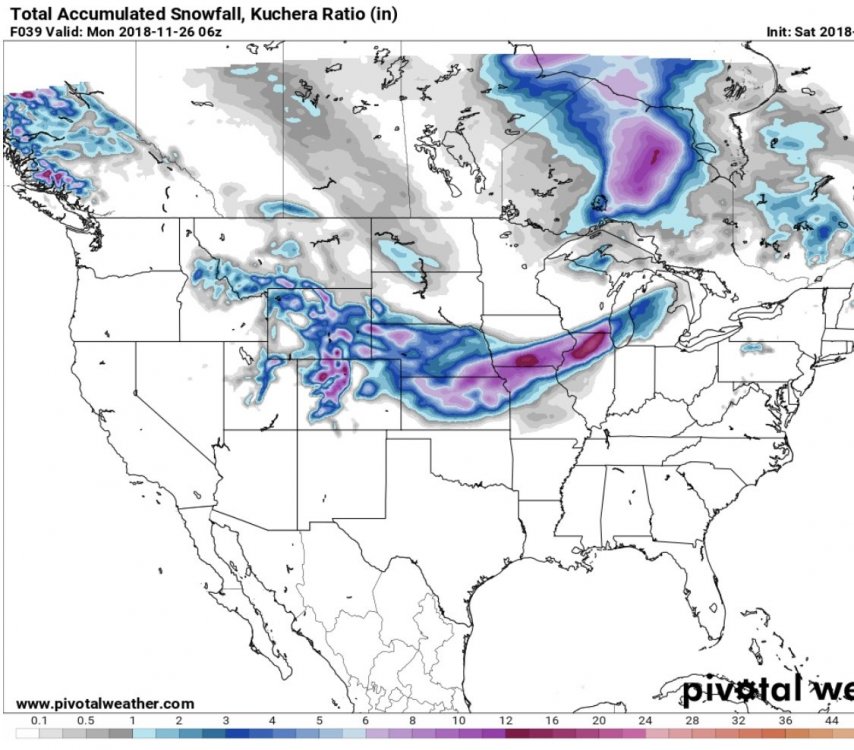
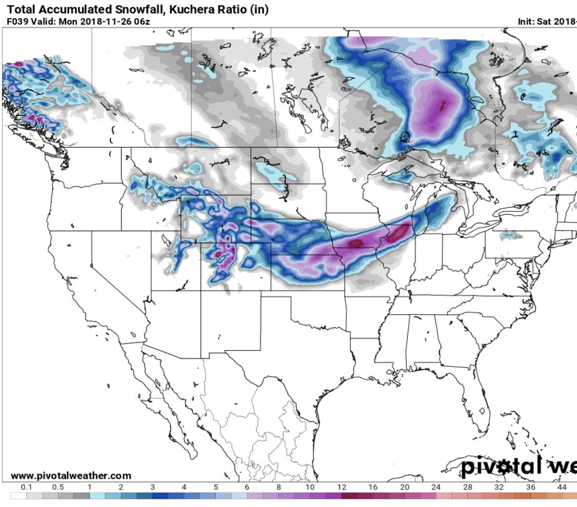
lol.... A classic Linn County cut-off. (Yes its kuchera but it's not my map and that's my excuse). As it always seems, CR is riding the edge on much of the guidance and 8" and literally nothing are both equally valid solutions.
-
Euro took a decent jump south, like the rest of 00z. CR/IC gets actively avoided by any formidable winter storm I swear.
EDIT: To support this, I've only measured 12" once in 10 years and Hawkeye never has.
-
1
-
-
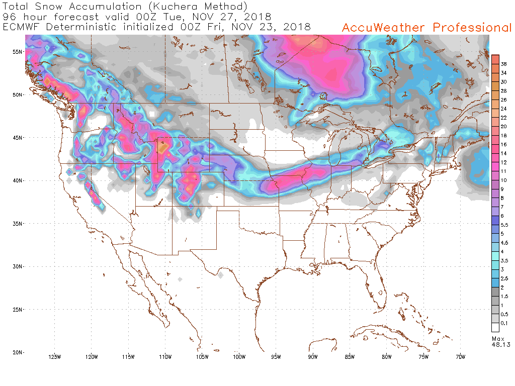
Very definite SE trend on the NAM and ICON at 00z.
-
5 minutes ago, Stebo said:
Is it an outlier? Euro/NAM/FV3-GFS all trended SE over the last day.
I’d still say so, it’s still well SE of the Euro and FV3 especially.
Nov. 25th-26th Midwest Snowstorm Potential
in Lakes/Ohio Valley
Posted
Some of the higher res guidance(and the GFS) have nudged north about half a county. Not enough for me, but maybe for Hawkeye? Could just be noise too. After all, it is very minute.