

hlcater
-
Posts
2,639 -
Joined
-
Last visited
Content Type
Profiles
Blogs
Forums
American Weather
Media Demo
Store
Gallery
Posts posted by hlcater
-
-
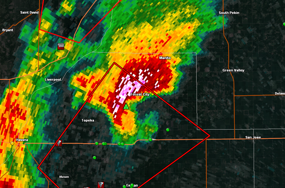
Cell near Forest City(SE lewistown) getting ready to undergo a cell merger with a weak, developing updraft. Interested to see how this turns out, but similar interactions have strengthened circulations in the past.
-
Storm near Morristown wrapping up.
-
Just now, Stebo said:
Absolutely classic. This event is far exceeding my expectation for today.
Worst part is, I would have chased it and my forecast was nearly perfect. So I would've seen these tornadoes. Alas I had other obligations so there was no chasing today even though I would've liked to.
-
What it looks like now

-
 1
1
-
-
Blurry pic of new

-
Just now, Hoosier said:
Can't remember exactly when but there was a shot like that a few years ago or so (also in IL). Would be even cooler to see it roll over a field that is completely snow covered.
That probably wouldn't happen. Would feel as if the lowered temperatures from the melting snow cover would make the immediate ground layer stable. Especially with complete snow cover moreso than just patches.
-
1 minute ago, SchaumburgStormer said:
Two separate areas of rotation on that one too
Both cells have CC drops. I'll note the one to the north was stronger than in my image, it had since weakened.
-
Just now, Stebo said:
I would be watching the storm south of the currently warned one. The current storm is coming down as the monster to the south of it is raining into it. I am shocked that storm isnt severe warned yet.
I'm by far most interested in the southernmost cell by Litchfield. Unimpeded inflow and the VWP is no worse down there.
-
From Chris Bray

-
From Devin Pitts. he called it violent in his own words

-
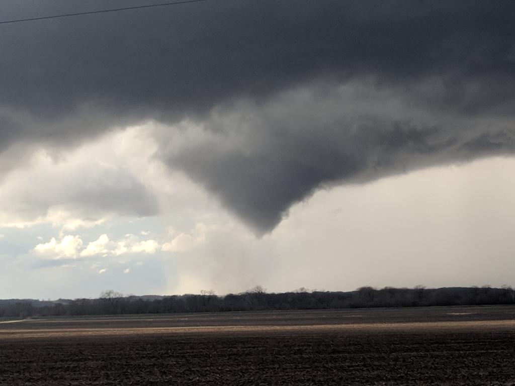
Another picture of the tornado near Griggsville.
-
9 minutes ago, Hoosier said:
Euro appears to be stuck at 48 hours. I need to know what it has!
I think it got unstuck. I have FH72 now.
-
12 minutes ago, cyclone77 said:
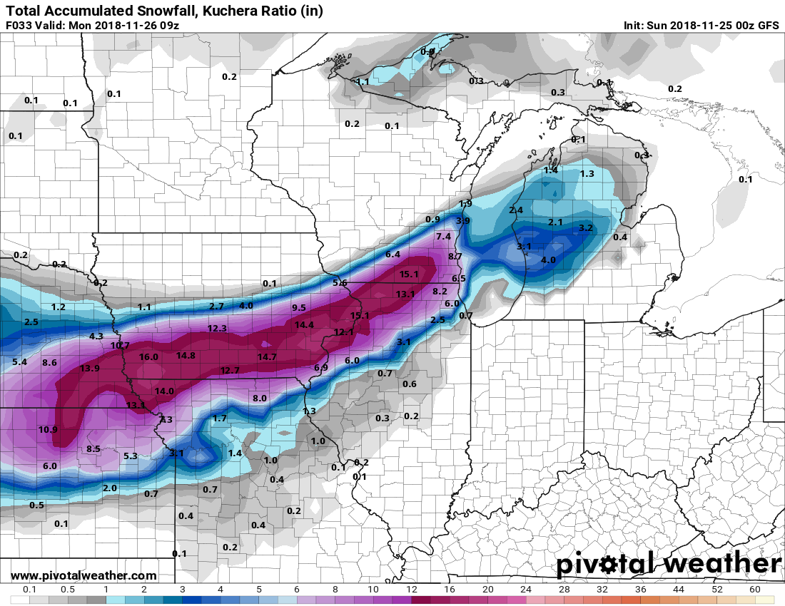
Picked up an unexpected 0.2" of very fluffy/light snow early this morning. Was actually supposed to be clear and allow temps to drop into the single digits. Temp ended up stalling up at 15. That brings us to 16" for the season already. To put that in perspective, we only had 8.9" at the end of January last season.
We got a dusting in Iowa City as well. Off topic, but the drive down here from CR, the cutoff from North Liberty to Coralville was insane. 4-5" in Coralville and bare ground in North Liberty. Haven't seen anything like it around here. We have about 7" on the U of I campus.
-
2
-
-
2 minutes ago, purduewx80 said:
pretty much a slam dunk blizzard for chicagoland is incoming. convection feeding into the ccb is always a good sign that gravity waves will easily penetrate down to the surface. same as in ghd2. that's a wall of snow incoming on radar, too.
No doubt that converts to snow with insane rates very shortly, but for the time being it looks like there's still a lot of sleet/mixed precip(especially SW of the metro).
-
Muscatine AWOS just recorded a 61mph gust.
Just recorded a second 67mph gust.
-
1
-
-
Relative just north of Chariton, IA just told me she got 15.5" of snow. It is no longer snowing there. I wouldn't be surprised to see a 20" report near Ottumwa. There are other reports from around there ranging from 12-14.
-
2
-
-
Just took an average of 5 measurements across my yard and came up with an average of 0.0" since midnight.
Iowa City has had reports of 6-8". Not sure I've seen a cutoff that sharp before. Even North Liberty(8 miles N of Iowa City) only reporting a trace.
-
1
-
 2
2
-
 2
2
-
-
That cut off is painful, but alas it was to be expected. Absolutely ripping snow 20 miles south of me. Not really expecting much more than flurries here, if that.
-
1
-
-
7 minutes ago, cyclone77 said:
Well, the 3km NAM just made the model porn hall of fame for this area. 3" of precip, and 2ft of snow. Obviously way overdone, but man this storm is really turning out to be something special.


It also showed like 0.50” of FZR for many areas. Not really sure what was up with that. Setup doesn’t really support it. Surface temps should cool slower than those aloft in this storm. I don’t see much of a window for any mixed precip really, maybe some sleet early on in heavier bands due to temps being slightly warmer(and above freezing) around 700mb but below freezing at 850mb but mostly just clean R/S.
-
6 minutes ago, Stebo said:
I would say the precip field has, I am looking at this from a low track point of view and to me the low tracks have been the same or in some cases especially east they have come further south.
That is one thing that struck me odd about the storm as a whole, the precip shield(especially the snow) was very close to the surface low. Every model was similar in that regard however. This storm was like that from the beginning though so never really expected that to change. Although the northward expansion of the precip shield as a whole is nice to see. It doesn’t take a whole lot of change out here with the cutoff the way it is.
-
1
-
-
11 minutes ago, Stebo said:
I must be missing something here, any shifts to the north this run cycle have been very minor and the HRRR has actually shifted a bit south run to run.
I might just be trash, but it sure looks like things have come north about a county(20 Miles) in Iowa. It’s not a lot, but enough to put CR back in contention.
-
Come to me my precious

-
2
-
1
-
-
2 minutes ago, IllinoisWedges said:
00z 12km NAM bumped NW.
And is also unrealistically juiced. 25.3” for Iowa City with 3”/hr rates. Sorry NAM, not happening. I foresee 12-15” in the heaviest axis of snow, but not nearly 25.
-
1
-
1
-
-
19 minutes ago, ConvectiveIA said:
I don’t know entirely but the future radar prediction tool on the weather channel is coming in looking really north. I have to wonder if that tool uses up to date modeling or how it is generated. But my hopes are up for you and Hawkeye.
Really dude? I’m wanting this to come north as much as you, but the TWC future radar is lolworthy. Don’t use it.
I dont expect t to come north but I’d be ecstatic if it did. Looks to slide just south of me, and that hasn’t really changed.
December 1 Severe Weather
in Lakes/Ohio Valley
Posted
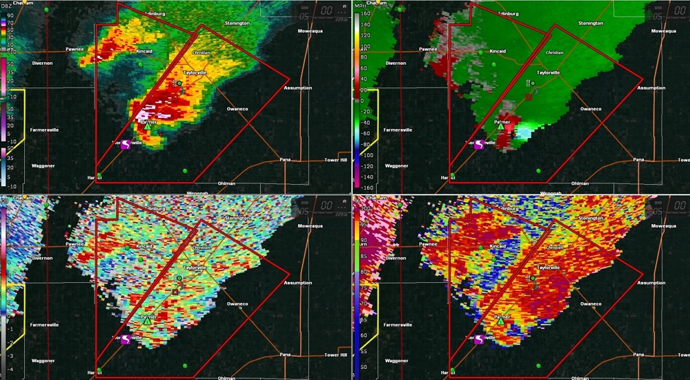
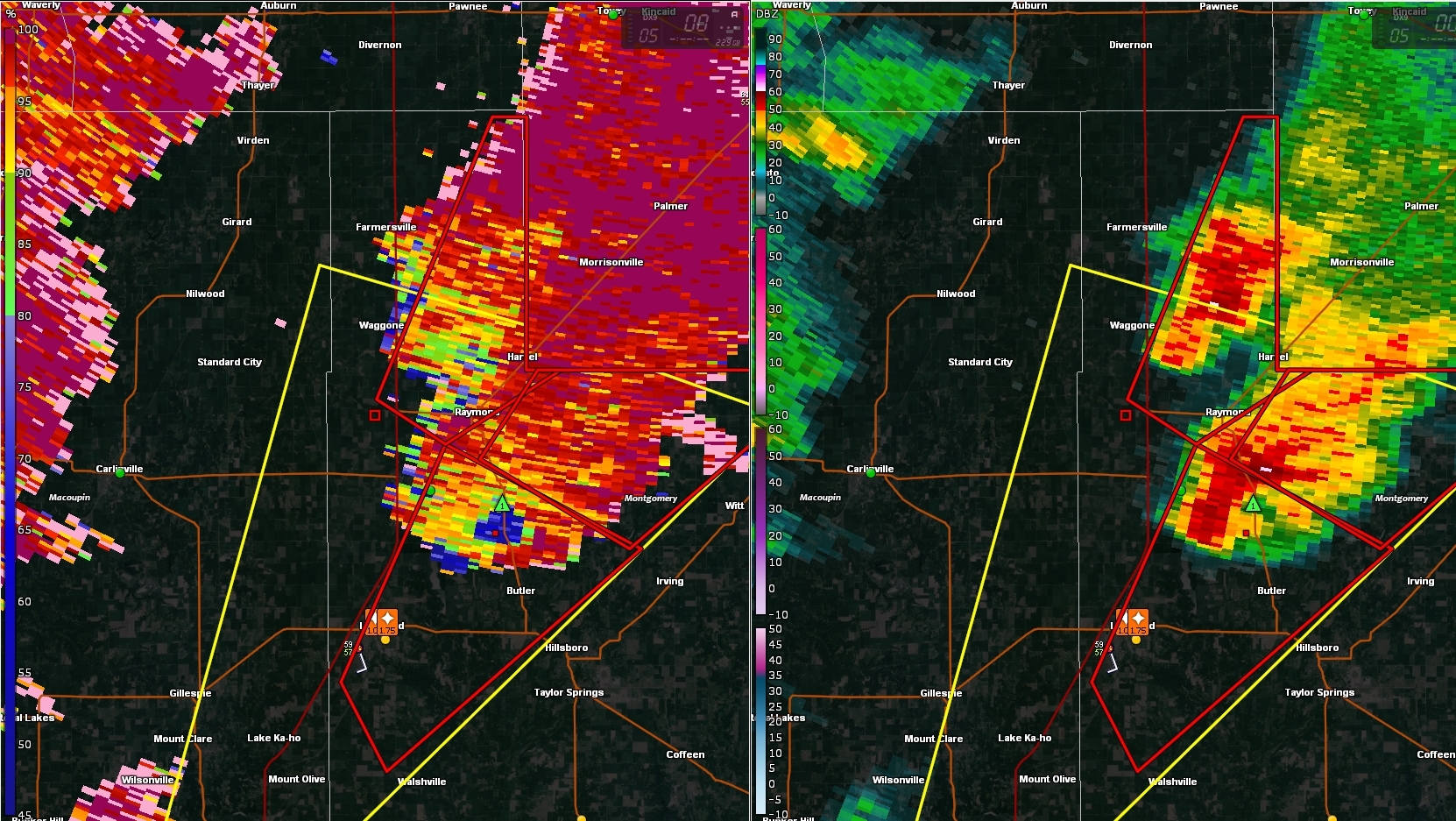
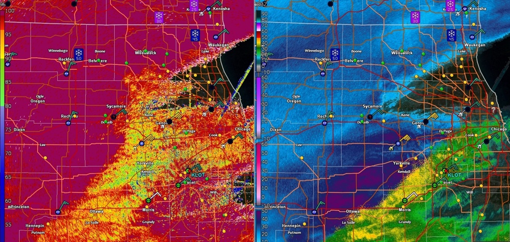
Tornado Emergency for Taylorville.