

hlcater
-
Posts
2,639 -
Joined
-
Last visited
Content Type
Profiles
Blogs
Forums
American Weather
Media Demo
Store
Gallery
Posts posted by hlcater
-
-
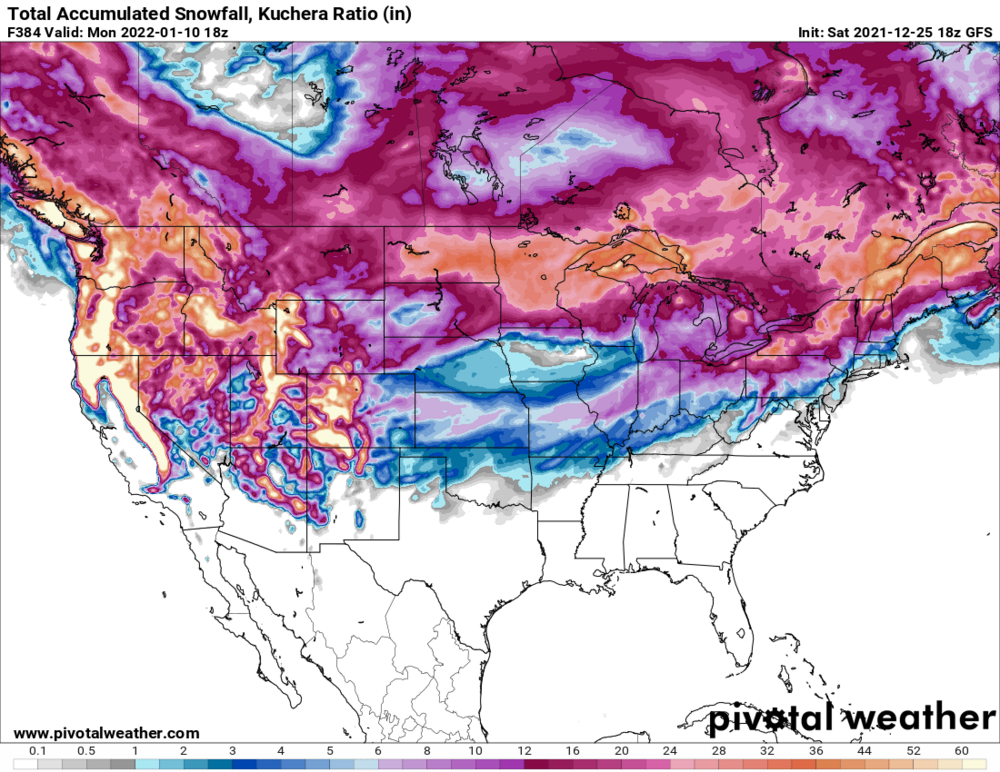
expecting the track to end up flatter than that in reality.
-
14 minutes ago, Malacka11 said:
Ahh. That's what I figured but I didn't even think it went out to the seven day mark
It doesn’t on pivotal but has an evolution that would yield a storm in the time frame of other models
-
 2
2
-
-
Just now, Malacka11 said:
This is a dumb question even by my standards, but what is the fourth of the big four? Euro, GFS, CMC are no brainers but I'm blanking on the last one for some reason
UKMET
-
2
-
-
Oh hell yes
-
 3
3
-
 2
2
-
-
grinch storm also implies that there is actually snow on the ground prior which is a major lol in 2021
-
1
-
-
Booking the WAD --> CAD transition
-
1
-
 1
1
-
-
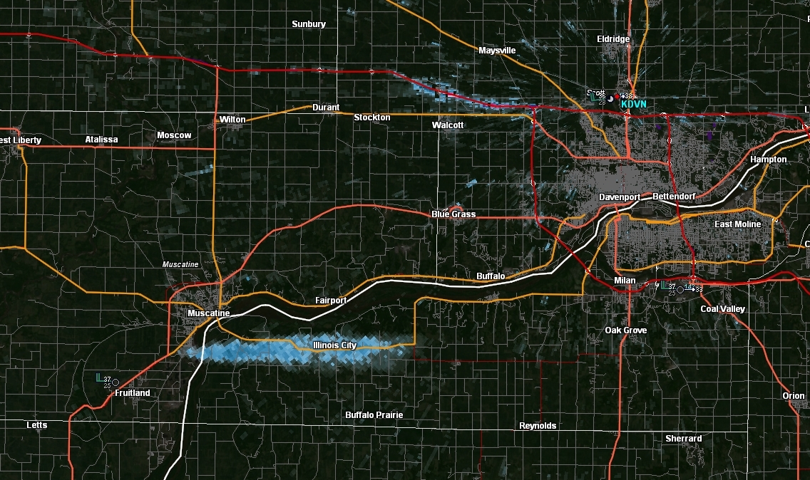
some sort of fire in muscatine.
-
would estimate winds of 60-65 out my window.
-
3
-
-
we're never going to see another EF5 rating ever again.
-
2
-
-
Just now, McHenrySnow said:
I knew they'd never go EF-5.
I bet you did
-
3
-
-
9 minutes ago, Chicago Storm said:
For anyone following the information Tim Marshall has been providing the past few days, a non-EF-5 rating should not come as a surprise.
.I'd be quite surprised if they stick with 190.
-
Our first 0.0" December likely on the table.
-
1
-
-
1 hour ago, purduewx80 said:
CAMs playing catch up.
Yea this is becoming a slam dunk tornado outbreak. You won't need supercells for tornadoes today. A QLCS will produce them just fine. If supercells become preferred in the area with the best shear vectors, I could see a 15H being necessary. The moisture overperformed even more than I expected. Looking at dews of 62-63 in the target area when as soon as yesterday, models had 57-58.
-
Wind driven moderate with a 10% tor. Did not expect that.

-
This setup has almost everything going for it except MLCAPE.
-
lol what the hell

-
The NAMs are essentially what you're looking for thermodynamically if you want a localized outbreak tomorrow.
1000 MLCAPE and hodographs taken from every other model not the NAM would suggest perhaps a strong tornado would be possible if you can get a sustained supercell.

-
2 minutes ago, purduewx80 said:
I was trying and apparently failed to say the caveat is definitely instability. The Gulf is wide open, and the Euro shows what is possible. The EPS has been showing increasing probs for a high end event, as well. I'm not saying there will be a lot of tornadoes, but some of the LEWPs embedded in the line should have no trouble producing. Widespread severe winds is the slam dunk here.
needs to be an enhanced risk for wind if you ask me.
Right now, 5/30/0 probs seem reasonable. Could see this going to a 10 if we're looking at 1000 MLCAPE by tomorrow morning.
-
2
-
-
Just now, purduewx80 said:
Decent chance it will. Low-level shear is outrageous but deep-layer shear suggests storms will quickly line out. Could be a mix of sups and LEWPs that produce after dark tomorrow imo. There are many indicators for long-trackers should the Euro's forecast instability materialize. Any capping there would easily be overcome by the dynamics ahead of the rapidly deepening, neg tilt 500mb wave. Below is an area avg sounding from the NE ~quarter of IA at 00Z tmrw eve.
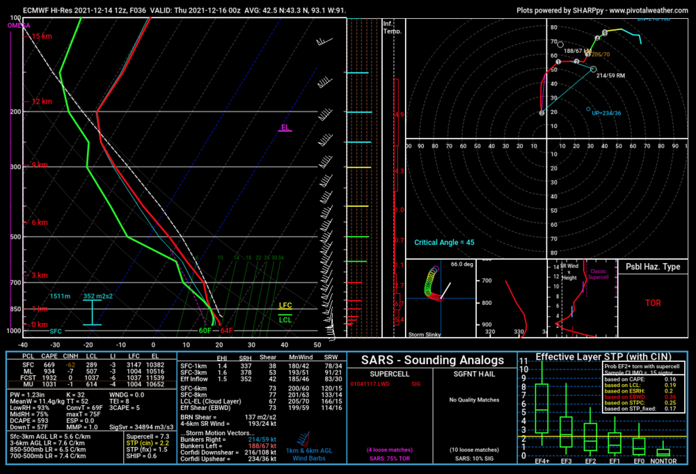
Surprised you're so bullish given the lack of substantial instability. That said, at 75kt RM, any tornado that persists for more than 10 minutes will be a longer tracked tornado.
The army of long tracked EF0s is upon us.
-
1
-
-
highly detailed satellite data from sections of the tornado track is being uploaded. I suggest all of you go take a look as its seriously some next level stuff. This was an EF5.
-
5
-
-
diggin it up
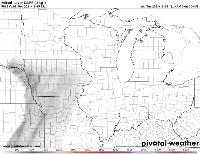
Highly anomalous neg tilt s/w ejecting wednesday afternoon looks poised to provide a damaging wind/tornado threat in IA/MN. Storm motions look to be some of the fastest I've ever seen beneath a 100 knot LLJ, so we're basically in uncharted territory with that. Currently, models show warm sector airmass characterized by upper 50s dews by 00z, but are very aggressive on mixing. Given strength of advection and potential cloud cover, I'm wondering if dews end up closer to 60-61 in reality. That is probably the difference maker between what is a few weak tornadoes and a localized outbreak. Secondly, forcing/ascent is exceptionally strong, so despite good shear vectors off the pacific front, would expect a QLCS in northern portions of the boundary with perhaps a few discrete/semidiscrete supercell structures to exist on the southern flank. An extremely dynamic system is in store and is certainly one that bears watching. I dont know of any good analogs to the parameter space.
As far as the ceiling of this event, concerns I have include aforementioned mixing, whether or not the MLCAPE available is enough to sustain an updraft in that hodograph, and potentially the tendency for mixed/linear modes from forcing.
Secondly, and courtesy of the 100kt 700mb jet, non thunderstorm wind gusts of 60-80mph appear possible across much of Iowa, especially if the models do end up being correct on the degree of mixing.


-
3
-
-
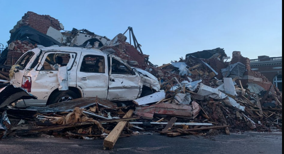
Here's some more damage pics. All of which are extremely impressive. It's getting to the point where I'll be stunned if this isn't EF5. The spatial extent and degree of intense damage is basically unparalleled in the modern era except for Hackleburg. We're talking a 100 mile strech (Cayce to Bremen) where there are high confidence EF4+ damage indicators. The damage present in Mayfield is not the worst that this tornado produced, or even close to it, and that says a lot.

-
2
-
1
-
-
Here is a gofundme organized by myself and a few other chasers if anyone is feeling generous. I personally vouch that they're going to a good cause. We looked through the list of charities and found the one we thought was best. We're 2000$ deep on the road to 10,000. Even if you can't donate, even something as little as spreading the link would do tremendous good!
https://www.gofundme.com/f/kentucky-tornado-disaster-relief
-
4
-
-
Would like to add that the HRRR initialized moisture terribly.
70s dews are already at the MO/AR border, where multiple stations are reading 70/70 or 68/68.


-
1
-


Winter 2021-22 Short/Medium Range Discussion
in Lakes/Ohio Valley
Posted
There's quite a lot of cold air/higher pressures to the north of the system in Canada pressing down. Think that suppresses the system at least some. The EC depiction from earlier today seemed like the most likely outcome to me.