

hlcater
-
Posts
2,670 -
Joined
-
Last visited
Content Type
Profiles
Blogs
Forums
American Weather
Media Demo
Store
Gallery
Posts posted by hlcater
-
-
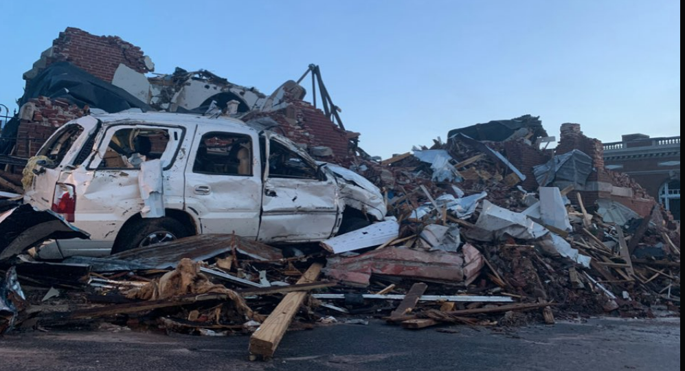
highly detailed satellite data from sections of the tornado track is being uploaded. I suggest all of you go take a look as its seriously some next level stuff. This was an EF5.
-
 5
5
-
-
diggin it up
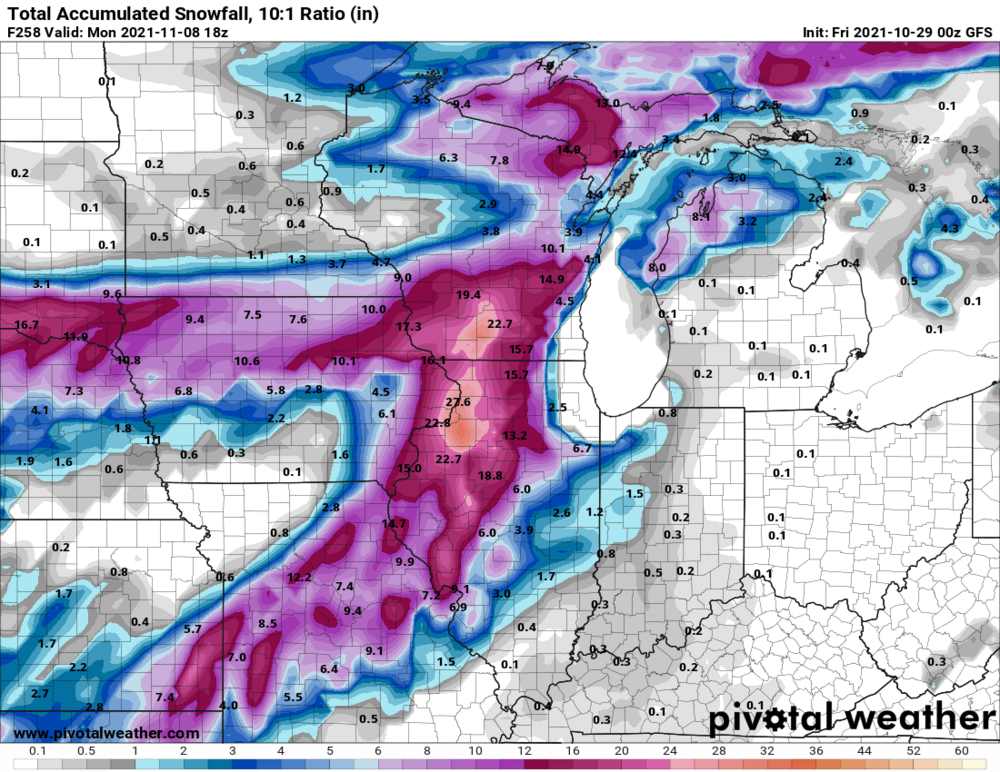
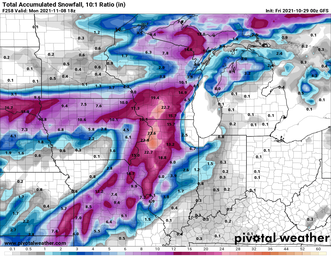
Highly anomalous neg tilt s/w ejecting wednesday afternoon looks poised to provide a damaging wind/tornado threat in IA/MN. Storm motions look to be some of the fastest I've ever seen beneath a 100 knot LLJ, so we're basically in uncharted territory with that. Currently, models show warm sector airmass characterized by upper 50s dews by 00z, but are very aggressive on mixing. Given strength of advection and potential cloud cover, I'm wondering if dews end up closer to 60-61 in reality. That is probably the difference maker between what is a few weak tornadoes and a localized outbreak. Secondly, forcing/ascent is exceptionally strong, so despite good shear vectors off the pacific front, would expect a QLCS in northern portions of the boundary with perhaps a few discrete/semidiscrete supercell structures to exist on the southern flank. An extremely dynamic system is in store and is certainly one that bears watching. I dont know of any good analogs to the parameter space.
As far as the ceiling of this event, concerns I have include aforementioned mixing, whether or not the MLCAPE available is enough to sustain an updraft in that hodograph, and potentially the tendency for mixed/linear modes from forcing.
Secondly, and courtesy of the 100kt 700mb jet, non thunderstorm wind gusts of 60-80mph appear possible across much of Iowa, especially if the models do end up being correct on the degree of mixing.


-
3
-
-
Here's some more damage pics. All of which are extremely impressive. It's getting to the point where I'll be stunned if this isn't EF5. The spatial extent and degree of intense damage is basically unparalleled in the modern era except for Hackleburg. We're talking a 100 mile strech (Cayce to Bremen) where there are high confidence EF4+ damage indicators. The damage present in Mayfield is not the worst that this tornado produced, or even close to it, and that says a lot.


-
2
-
 1
1
-
-
Here is a gofundme organized by myself and a few other chasers if anyone is feeling generous. I personally vouch that they're going to a good cause. We looked through the list of charities and found the one we thought was best. We're 2000$ deep on the road to 10,000. Even if you can't donate, even something as little as spreading the link would do tremendous good!
https://www.gofundme.com/f/kentucky-tornado-disaster-relief
-
4
-
-
Would like to add that the HRRR initialized moisture terribly.
70s dews are already at the MO/AR border, where multiple stations are reading 70/70 or 68/68.


-
1
-
-
I-70 corridor looks primed for the potential of significant tornadoes tonight. HRRR has been relatively consistent bringing a long tracked discrete supercell through a fairly volatile environment. Additionally, with the rate of moisture advection being observed on stations to the south, I wouldn't be surprised if the true environment along I-70 ends up being in the neighborhood of 67/65 or so. Given that thermos are the biggest thing that the HRRR sees as limiting that environment, better than progged moisture would certainly make things interesting. I feel as if the moderate should've been expanded northward to account for this possibility.

-
6 minutes ago, cyclone77 said:
70 in December, -30 in January.
There’s plenty of cold sitting in the Yukon and Alaska just waiting to go on a conus tour.
-
1
-
-
5 hours ago, A-L-E-K said:
Probably something to that, amplification and all
I said that elsewhere. Anecdotally these big torches seem to almost always snap back to anomalous cold within a few weeks after ending and vice versa.
-
ready 2 b torched
-
1
-
-
2 hours ago, Thundersnow12 said:
Wagons south look getting smell
-
The solution to getting snow across portions of iowa seems to be letting the low deepen quickly. The 18z euro has a far better developed deformation zone to the west of the low compared to other models and has 1-4" across eastern iowa because of it.
-
-
GFS has a system in the medium range that hasn't shown up previously

-
2
-
-
Perpetual cool NW flow with absolutely zero precip to be seen.
December 2017 vibes.
-
This pattern is just brutal
-
3
-
-
I’d say 20-24” in CR. There is precedent for large storms elsewhere in Iowa, CR has just had an epic run of bad luck and is not representative of climo imo.
-
 1
1
-
-
First flakes in Iowa city today. No accumulation as expected
-
1 hour ago, Baum said:
thinking tomorrow ends up more interesting in these parts than the weekend impulse:
"A MORE POTENT PV ANOMALY IS EXPECTED TO ROTATE AROUND THE MID-
LEVEL LOW LATE TONIGHT, BEFORE SHIFTING ACROSS NORTHERN IL ON
FRIDAY. THIS WILL SET THE STAGE FOR SCATTERED TO NUMEROUS
CONVECTIVE SHOWERS (PRIMARILY IN THE FORM OF SNOW) ACROSS THE
AREA LATER FRIDAY MORNING THROUGH MUCH OF THE AFTERNOON. SIGNS
CONTINUE TO POINT TO SOME BRIEF MODERATE TO HEAVY BURSTS OF SNOW
AND GRAUPEL WITHIN THESE SHOWERS GIVEN THE 7+C/KM SURFACE TO
675MB LAPSE RATES AND NEAR ZERO WET-BULB ZERO HEIGHTS. WITH THIS
IN MIND, I CONTINUED TO HIT THE HEAVY WORDING OF THE SNOW SHOWERS
IN THE FORECAST. I HAVE LEAVE THE MENTION OF THUNDER OUT OF THE
FORECAST AT THIS TIME, THOUGH MODEL SOUNDINGS DO INDICATE THE
POTENTIAL OF CHARGE SEPARATE IN THE CLOUDS, WITH SOME CAPE NOTED
EXTENDING THROUGH THE -10 TO -20C LEVEL. OVERALL, THE PRIMARY
IMPACTS FROM THESE HEAVY SNOW SHOWERS WILL BE BRIEF PERIODS OF
SHARPLY REDUCED VISIBILITIES TO 1 MILE OR LESS, AND SOME LOCALLY
HIGHER WIND GUSTS. SOME MINOR SNOW ACCUMULATIONS ARE POSSIBLE,
ESPECIALLY ON GRASSY AREAS AND ELEVATED SURFACES. OTHERWISE,
EXPECT THE SNOW SHOWERS TO WIND DOWN FOR MOST BY EARLY FRIDAY
EVENING. ONLY SOME LINGERING LAKE EFFECT SNOW SHOWERS ARE EXPECTED
TO PERSIST FRIDAY NIGHT ACROSS PARTS OF NORTHERN IN AND
SOUTHEASTERN LOWER MICHIGAN. "This turn towards true November weather is right on cue. Not a crazy or exteme pattern. Gradual step down to seasonality. Good sign IMO.
agreed. This gradual slope down to winter has been somewhat atypical over the past 5-6 seasons.
-
5 hours ago, A-L-E-K said:
he should take the winter off imo, let some of the young guns have a run
hoosier loves it when the young
gunsrun-
 1
1
-
-
Looking like several snow chances in the sub after about day 5. More or less on schedule I guess
-
2
-
-
in a coma
-
What a beautiful image
-
1
-
-
how do I post as guest
-
I prefer wet n' wild
-
3
-
2021 Short/Medium Range Severe Thread
in Lakes/Ohio Valley
Posted
Surprised you're so bullish given the lack of substantial instability. That said, at 75kt RM, any tornado that persists for more than 10 minutes will be a longer tracked tornado.
The army of long tracked EF0s is upon us.