

hlcater
-
Posts
2,686 -
Joined
-
Last visited
1 Follower

About hlcater

Recent Profile Visitors


-

Winter 2025-26 Short Range Discussion
hlcater replied to SchaumburgStormer's topic in Lakes/Ohio Valley
Vis has been under 1 mile for the past hour or so. Eyeing about 1.5" down so far, which is already better than the NBM. CAM guidance was consistently north with this system, which will be a whiff. -
Winter 2025-26 Medium/Long Range Discussion
hlcater replied to michsnowfreak's topic in Lakes/Ohio Valley
torchin -
Winter 2025-26 Medium/Long Range Discussion
hlcater replied to michsnowfreak's topic in Lakes/Ohio Valley
palms gonna be loving the upcoming pattern -
Winter 2025-26 Medium/Long Range Discussion
hlcater replied to michsnowfreak's topic in Lakes/Ohio Valley
You'd think that the amount of snow we have going into mid december would guarantee a white christmas, but the pattern going into the holidays isnt exactly favorable for snowpack retention. Going 40/60 odds, respectively. -
If this turns into glacier, its not going anywhere fast. Especially with indications of subsequent dusters/clippers following behind. Probably 13-14" OTG here.
-
Winter 2025-26 Medium/Long Range Discussion
hlcater replied to michsnowfreak's topic in Lakes/Ohio Valley
Some reason to believe week 3 might be a return to a cooler pattern which is why I posted in the other thread that the lead system this weekend matters so much as it would help mitigate warming in week 2 in the northern half of the sub. -
Need the clipper this weekend to trend stronger A-la the euro to ward off scary evil spirits (the baroclinic zone). Stronger lead wave suppresses everything that follows it leading to a less amplified, further SW storm track.
-
Nov 28-30th Post Turkey Day Winter Storm
hlcater replied to Chicago Storm's topic in Lakes/Ohio Valley
10.2" on the stick. Perhaps another inch yet to go per guidance and radar trends. -
Nov 28-30th Post Turkey Day Winter Storm
hlcater replied to Chicago Storm's topic in Lakes/Ohio Valley
Probably 9" or so with the best rates of the event underway. Think 12" is probably gonna be optimistic but we should beat 10" -
Nov 28-30th Post Turkey Day Winter Storm
hlcater replied to Chicago Storm's topic in Lakes/Ohio Valley
Dont really see anything to dislike on the 00z runs. Gonna go with a potentially conservative guess of 8". -
Nov 28-30th Post Turkey Day Winter Storm
hlcater replied to Chicago Storm's topic in Lakes/Ohio Valley
bring it -
Major Hurricane Melissa - 892mb - 185mph Jamaica landfall
hlcater replied to GaWx's topic in Tropical Headquarters
Rumor is they're gonna do one more pass. -
Major Hurricane Melissa - 892mb - 185mph Jamaica landfall
hlcater replied to GaWx's topic in Tropical Headquarters
Regarding EWRC: Interested to see if that large area of subsidence between the core and the feeder bands acts to delay formation and consolidation of that outer band into a secondary eyewall.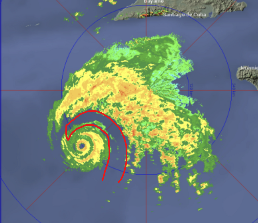
-
Major Hurricane Melissa - 892mb - 185mph Jamaica landfall
hlcater replied to GaWx's topic in Tropical Headquarters
One thing I want to comment on here is that the instability of the eye/trochoidal wobbling that was present earlier now no longer is. The eye has warmed, become more stable, and is now definitively moving northeast towards Jamaica as a steady state or strengthening sub-910mb storm. Terrifying stuff unfolding here. -
Major Hurricane Melissa - 892mb - 185mph Jamaica landfall
hlcater replied to GaWx's topic in Tropical Headquarters
Unfortunately, with atmospheric conditions progressively becoming more favorable with each passing hour, I do not see a scenario where Melissa does not efficiently achieve its MPI. Land interaction or internal structural changes are the only limiting factors until it's picked up by the trough in a few days. I am trying to be optimistic for dry air intrusions or a well timed ERC but that might be wishful thinking. Neither is a given.


