Wurbus
-
Posts
666 -
Joined
-
Last visited
Content Type
Profiles
Blogs
Forums
American Weather
Media Demo
Store
Gallery
Everything posted by Wurbus
-
I've been waiting for a dishwasher to be scheduled for delivery for a week and half now. They called today and scheduled it for Feb 14th, so I bet we get a snow on the 13th or 14th.
-
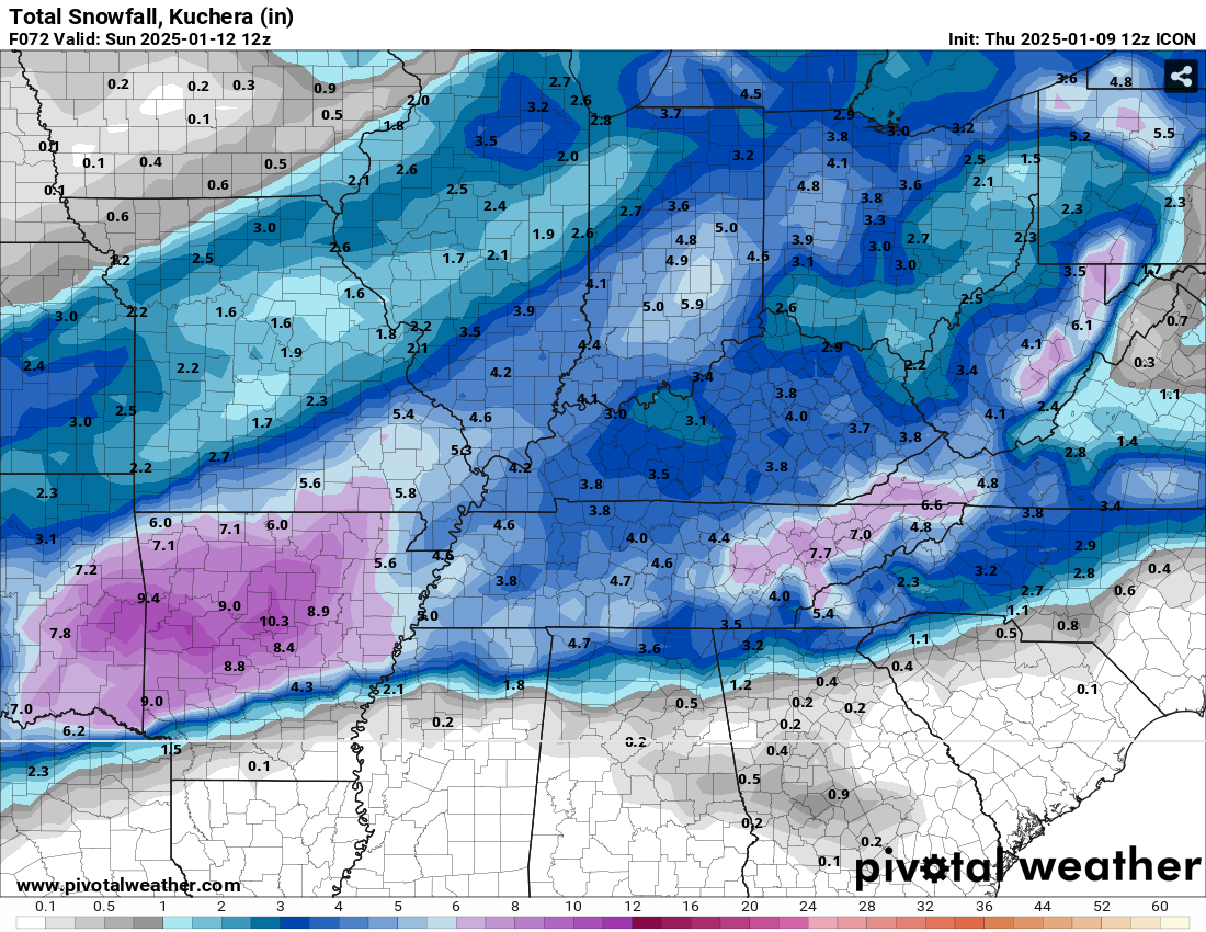
ICON was a big nothing burger for the Tuesday system. Suppressed to all hell and doesn't get a good phase. Even had some snow south of New Orleans in the gulf lol
-
Yeah, GFS has to be out to lunch at this point
-
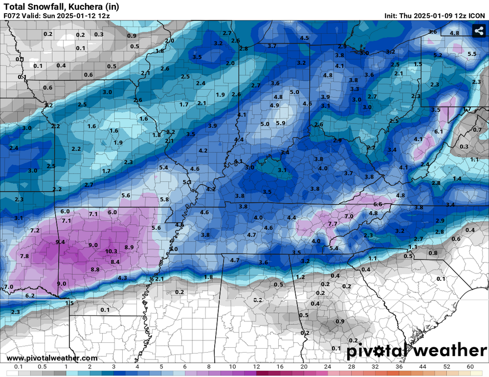
CMC/ICON is going to be similar, but the CMC is more juiced. Kuchera snowfall maps are going to be off the charts from TX to NC.
-
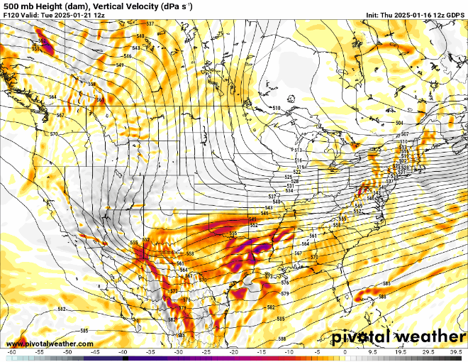
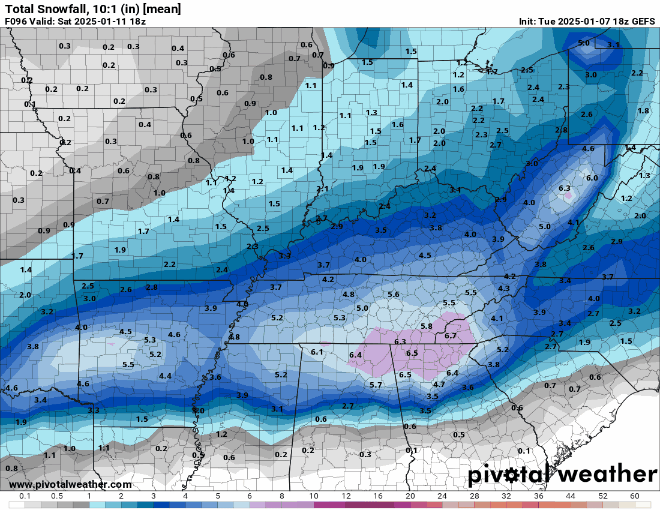
The difference between the GFS & CMC at 120 hrs is staggering at the 500mb level.
-
ICON did come north compared to 0z and really hammers mid-southern MS, central AL/GA, SC, & Eastern NC. Some light snow makes it up to 40.
-
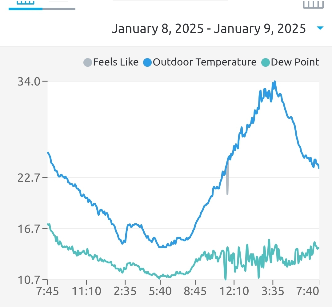
My weather station recorded 5 nights with single digit lows and one below 0 night.
-
I measured 3 1/2 inches in several places with a solid layer of freezing rain in the middle of it that I had to punch through. If it wasn't for that, I think I would have wound up in the 4-6 forecast.
-
Same for me as well. I have a nice light freezing rain at 27 degrees
-
dry slot moving up through Knoxville now
-
I just measured a little over 2 inches in several spots. I'm reduced to a fine pixie dust at the moment. Been sitting at 26 degrees for several hours now.
-
Definitely ripping snow now in Karns/Cedar Bluff area.
-
Another banger run for GFS incoming. CMC was also good and both models seem hellbent on bringing the polar vortex down after the 22nd. Not sold on that since they were also signaling that feature a few weeks ago, but if we can keep the pattern going, that is a win in my book.
-
Took about 30 mins to get a dusting from when it started. My road is already covered, so not much melting at all. Temp down to 26 and DP up to 23 now.
-
Finally seeing the first flurries here in the Cedar Bluff/Karns area in Knoxville. Temp at 28 and dewpoint at 18.
-
I know everyone is focused on the current storm, but that was an absolute banger of a 6z GFS run.
-
My temp drop seems to have leveled off around 23. DP still quite low though.

-
Slight uptick on the snow average on the plumes across most of East TN. Generally about .2-.5 increase compared to 9z. I think most of that is due to slightly less mixing.
-
ICON hammered the valley
-
What is the difference between the ARW & NSSL on the HRW model? NSSL does have some WAA entering the valley toward the end of the run.
-
Looks like snow means increased for most everyone compared to 15z on the SREF plumes. Closer to what they were at 9z this morning.
-
Highs were in the 40's and 50's leading up to the event last year in Knoxville. Lows were in the uppers 20's or low 30's mostly.
-
I noticed the 3pm plumes also came down about an inch average for KNX and Chattanooga decreased a fair amount as well.
-
GEFS mean remains beefy, but the biggest amounts shifted from Chattanooga area to Arkansas and Memphis.
-
Did the 0z CMC run? I don't see it available on pivotal or tropical tidbits.