sbnwx85
-
Posts
1,818 -
Joined
-
Last visited
Content Type
Profiles
Blogs
Forums
American Weather
Media Demo
Store
Gallery
Everything posted by sbnwx85
-
GFS bringing me back in the game baby!
-
Here's the operational run of the 18z Euro run:
-
Just catching up on everything...just want to add it is nice to have @Stebo back posting. You were definitely missed, especially during the ice storm. Would have been great to have your insight. I try to stay out of OT because the few times I've visited I was overwhelmed by the gross drama. While I'm not clueless to why Hoosier was banned I can't say I'm surprised based on what I've seen. We can't have that kind of behavior here. Alright back to weather posts and memes.
-
-
There's that trusty southeast trend I've been waiting for!
-
With 1.3" of snow in February at KSBN this will go down as the 6th least snowiest February. Interestingly, this was the 7th most precipitation in a February on record (4.12").
-
-
-
Gorgeous spring afternoon following a day with Tornado Warnings. Best climo.
-
I’ve conceded this to be a rain maker in Northern Indiana that way if there’s a SE shift I’ll be pleasantly surprised.
-
Just your typical 100 mile northwest shift on the Euro. Ensembles indicated it was only a matter of time before the operational caught on. Another cold rain on the way. Congrats Chicagoland.
-
I wouldn't put any stock into the NAM until 24 hours out.
-
I don't really like that the axis of heaviest snow totals on both the GEFS and EPS are northwest of me right now. I'd hate another cold rain...but on the other hand not having to deal with a snowstorm while trying to travel on Friday night would be nice.
-
Gotta love this time of year. Tornadoes to start the week...the threat of a snowstorm to end it!
-
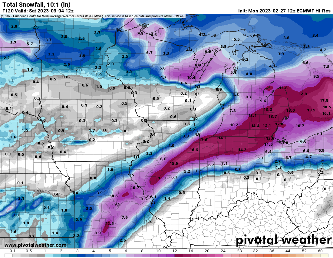
Money run for the Greater Michiana Area on the Euro. Best model. Edit: Add snowfall map.

-

2023 Short/Medium Range Severe Weather Discussion
sbnwx85 replied to Chicago Storm's topic in Lakes/Ohio Valley
No damage reported anywhere in Northern IN at the moment. Some reports of nickel and quarter size hail. Heavy rain...but still have yet to hear my first rumble of thunder of the year. -
2023 Short/Medium Range Severe Weather Discussion
sbnwx85 replied to Chicago Storm's topic in Lakes/Ohio Valley
To say I’m surprised to see a Tornado Warning a county to my west is an understatement. -
We have a winner. No more contestants please. No more shifts. This is it.
-
It would be cool to have my two largest snowfalls occur before and after meteorological winter.
-
Winter 2022/23 Short/Medium Range Discussion
sbnwx85 replied to Chicago Storm's topic in Lakes/Ohio Valley
Just starting here. Should get some heavy stuff in a few minutes. -
Saw some flurries today. I think I counted 8 flakes.
-
Winter 2022/23 Medium/Long Range Discussion
sbnwx85 replied to Chicago Storm's topic in Lakes/Ohio Valley
I'm trying hard to reel that bad boy on Friday northwest. -
If we can avoid any snow accumulation the rest of the month, which seems likely, this will go down as the 2nd least snowy February on record in South Bend. We've had 0.3" of snow so far. The record is a Trace in 1998.
-
Not sure if this was posted here or not because I’ve been looking at a lot of information sources, but some power companies in Southeast Michigan aren’t going to start restoring power until sunrise because it’s too dangerous to be out right now.
-
Winter 2022/23 Medium/Long Range Discussion
sbnwx85 replied to Chicago Storm's topic in Lakes/Ohio Valley
Fun to look at though.