

sbnwx85
-
Posts
1,933 -
Joined
-
Last visited
Content Type
Profiles
Blogs
Forums
American Weather
Media Demo
Store
Gallery
Everything posted by sbnwx85
-
Report of thunder in Mishawaka.
-
-
Still dealing with rain/sleet/snow mix. Total on the grass is 1.5". Total on the cement/cars is 0.75".
-
Rain mixing in. Boo. Hoping it doesn't last too long.
-
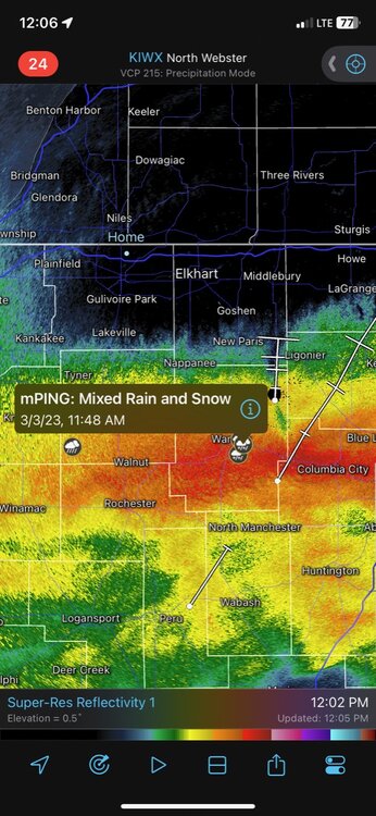
Temp down to 33. Visibility at a 1/2 mile. Roads are snow covered. Nice banding showing up overhead on radar. Stronger winds should be here in about an hour. Great start to this.
-
18z HRRR
-
Started ripping fatties at work. Starting to stick to the roofs and grass. Here's our camera: https://wsbt.com/weather/storm-alert-weather-cameras/mishawaka
-
You know it's going to be a crazy storm when our morning mets at the tv station are staying past noon.
-
Precipitation just began here. Started as a rain/sleet/snow mix. Transitioning to rain/snow mix quickly. I hope it’s a good sign it’s starting off as partially frozen precip.
-
Several rain and snow mix reports on RadarScope in Kosciusko County.
-
Good, detailed update from IWX: UPDATE... Issued at 1007 AM EST Fri Mar 3 2023 The forecast for this very complicated system remains on track at this time. The only change to headlines was to break-out the eastern extent of the advisory to better represent the expected snowfall there. Rain is moving into my southern counties as of this writing. Rain looks to be somewhat heavy, even at the onset, with visibilities below 3 miles being reported and radar estimated rates of 0.25-0.5"/hour. Farther north, dew point depressions vary but are generally small at 4-7 degrees. This bodes well for quick onset of precipitation there toward midday. Other observation notes include warming cloud tops locally, but reinvigorated convective elements over far southwest IN, indicating a strengthening section of this storm system there. Wind gusts over Central IN are already gusting to 35 knots which increases confidence on the wind forecast locally. Mesoscale models are showing a trend to the WSW with the swath of heavy snow, depicting a very tight gradient in snow amounts across locations such as Berrien and LaPorte Counties (i.e. little snow toward Lake MI. The eastern extent of our forecast still looks ok). A four-panel water vapor loop over the last several hours shows the overall storm system still lifting north, so I`m not sure that I want to chase that trend in the mesoscale models quite yet. Surface wet bulb temperatures advertised in the mid-and-upper 30s makes me nervous that rain may prevail longer than forecast, even in the north. However, forecast soundings continue to show a change over to snow as the atmospheric column cools in response to very heavy precipitation rates. Cross sections over the forecast area, perpendicular to the expected area of heavy snow, still show incredible lift via intense omega, mid-level frontogenesis, and instability aloft. With the anticipated low ratios, I still have my doubts on the highest values of our snow forecast, but these dynamics are no joke. Confidence is not high enough to make notable changes to the forecast. Regardless of final snow totals, the heavy snow rates will cause travel problems in a hurry, likely catching folks off guard.
-
I could live with the 3k NAM.
-
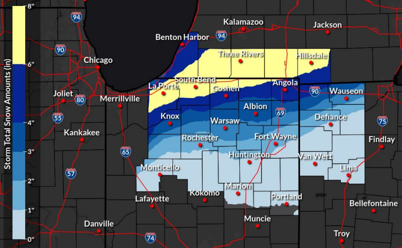
HRRR has me down to like 4.5” on the Kuchera map.
-
I can’t wait to see how this plays out tomorrow. I would love to hear thundersnow for the first time. I hope media gets the word out about how impactful this could be because everyone has been super cautious with totals. I have a feeling a lot of people are going to be caught off guard.
-
Really starting to get jazzed up for this, you guys. Even if amounts the models are spitting out are cut in half this will create near whiteout conditions for a time.
-
Axis of snowfall appears about the same on this run of the HRRR as the previous run. Just using snow depth I got an extra inch of snow this run. I'm still trying to temper expectations. 00z 18z
-
-
-
From the IWX powerpoint update at 3:00 PM: Edit to add IWX also hitting the potential of power outages hard.
-
18z HRRR
-
@Baumcan we lock this in? My point and click is at 5"-9". The mets at my TV station (aka work) were still going with a broad 2"-4" across the area this morning. I wonder if they'll bump it up this afternoon.
-
Sorry to say for the Chicago crew, but I'm stealing this one.
-
Whoever is underneath that heaviest banding is going to see wild conditions for a couple hours. Too bad this storm is moving so quickly.
-
Lol fair but I think if 3” per hour rates are actually realized someone will end up with big totals.
-
This is as “thread the needle” as it gets.


