sbnwx85
-
Posts
1,783 -
Joined
-
Last visited
Content Type
Profiles
Blogs
Forums
American Weather
Media Demo
Store
Gallery
Everything posted by sbnwx85
-
Just your typical 100 mile northwest shift on the Euro. Ensembles indicated it was only a matter of time before the operational caught on. Another cold rain on the way. Congrats Chicagoland.
-
I wouldn't put any stock into the NAM until 24 hours out.
-
I don't really like that the axis of heaviest snow totals on both the GEFS and EPS are northwest of me right now. I'd hate another cold rain...but on the other hand not having to deal with a snowstorm while trying to travel on Friday night would be nice.
-
Gotta love this time of year. Tornadoes to start the week...the threat of a snowstorm to end it!
-
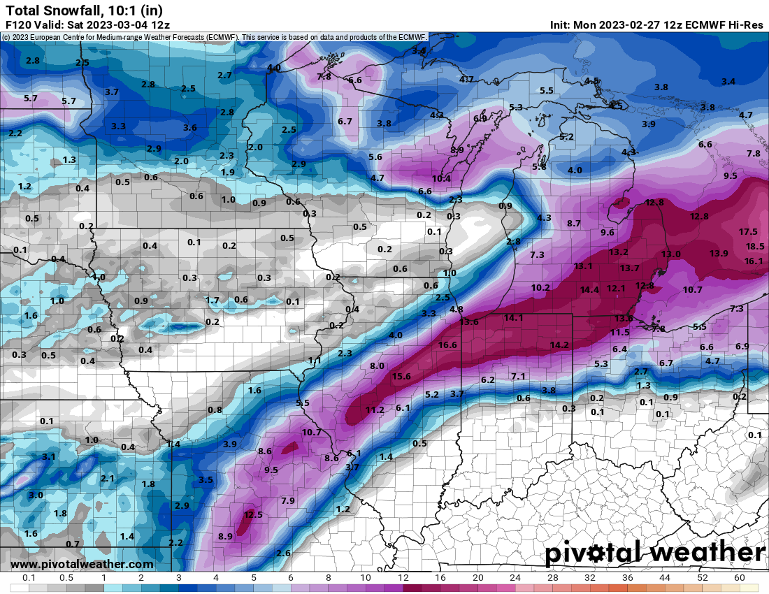
Money run for the Greater Michiana Area on the Euro. Best model. Edit: Add snowfall map.

-

2023 Short/Medium Range Severe Weather Discussion
sbnwx85 replied to Chicago Storm's topic in Lakes/Ohio Valley
No damage reported anywhere in Northern IN at the moment. Some reports of nickel and quarter size hail. Heavy rain...but still have yet to hear my first rumble of thunder of the year. -
2023 Short/Medium Range Severe Weather Discussion
sbnwx85 replied to Chicago Storm's topic in Lakes/Ohio Valley
To say I’m surprised to see a Tornado Warning a county to my west is an understatement. -
We have a winner. No more contestants please. No more shifts. This is it.
-
It would be cool to have my two largest snowfalls occur before and after meteorological winter.
-
Winter 2022/23 Short/Medium Range Discussion
sbnwx85 replied to Chicago Storm's topic in Lakes/Ohio Valley
Just starting here. Should get some heavy stuff in a few minutes. -
Saw some flurries today. I think I counted 8 flakes.
-
Winter 2022/23 Medium/Long Range Discussion
sbnwx85 replied to Chicago Storm's topic in Lakes/Ohio Valley
I'm trying hard to reel that bad boy on Friday northwest. -
If we can avoid any snow accumulation the rest of the month, which seems likely, this will go down as the 2nd least snowy February on record in South Bend. We've had 0.3" of snow so far. The record is a Trace in 1998.
-
Not sure if this was posted here or not because I’ve been looking at a lot of information sources, but some power companies in Southeast Michigan aren’t going to start restoring power until sunrise because it’s too dangerous to be out right now.
-
Winter 2022/23 Medium/Long Range Discussion
sbnwx85 replied to Chicago Storm's topic in Lakes/Ohio Valley
Fun to look at though. -
Had some pretty hard rain. Flash flooding possible tonight. Mesoscale Precipitation Discussion 0072 NWS Weather Prediction Center College Park MD 433 PM EST Wed Feb 22 2023 Areas affected...central/northern IL into northern IN, northwestern OH and southern MI Concerning...Heavy rainfall...Flash flooding possible Valid 222130Z - 230330Z SUMMARY...Heavy rain will continue a threat for flooding from central/northern IL into northern IN and extreme northwestern OH/southern MI. Peak rainfall rates of just over 1 in/hr will allow for an additional 1 to 2 inches of rain through 03Z, but rainfall intensity is expected to decrease with time. DISCUSSION...Regional radar imagery at 21Z showed a broad shield of precipitation extending to the north and northeast of a surface low analyzed over central IL. Localized reports of 1+ in/hr have occurred across portions of central IL over the past few hours where the SPC mesoanalysis indicated MUCAPE near 100 J/kg and precipitable water values of 1.2 to 1.4 inches. MRMS and gauge reports indicated 1 to 3 inches of rain has fallen over the past 12 hours from central IL into north-central IN. Across far northern IN/OH into southern MI, surface temperatures near 32 have supported areas of freezing rain with the freezing line expected to only marginally lift north over the next few hours. As a negatively tilted shortwave over the mid-Mississippi Valley continues to advance northeastward, it is expected to maintain a weakening trend and support the ENE track of the surface low over central IL toward northwestern OH. South-southwesterly 850 mb winds of 50 to 60 kt just ahead of the shortwave and surface low are expected to continue strong ascent over a well-defined warm front extending eastward from the low. Elevated instability is only about 100-200 J/kg according to the 20Z SPC mesoanalysis but is forecast to gradually lower over the next 3-6 hours which should reduce peak rainfall intensity to 0.5 to 0.75 in/hr beyond 00Z. An additional 1-2 inches of rain is expected through 03Z, with rainfall ending from west to east. Expected rainfall should near area 3-hr flash flood guidance of 1 to 1.5 inches, but should primarily lie north of the axis of heavy rain that has fallen over the past 12 hours. Nonetheless, localized areas of flooding will be possible, within a fairly narrow corridor between the warm front and frozen precipitation to the north over southern MI. Otto
-
Winter 2022/23 Medium/Long Range Discussion
sbnwx85 replied to Chicago Storm's topic in Lakes/Ohio Valley
33 and rain has me posting fantasy Euro storms. Sad! -
Winter 2022/23 Medium/Long Range Discussion
sbnwx85 replied to Chicago Storm's topic in Lakes/Ohio Valley
^What could go wrong this far out? -
Just posted about that in the medium/long range thread. Trying to reel it in for us. It's probably our last hope before "spring".
-
Winter 2022/23 Medium/Long Range Discussion
sbnwx85 replied to Chicago Storm's topic in Lakes/Ohio Valley
I'm telling you right now...this is gonna be the big one for us. GFS has a storm, too, but it'll come around and slide west soon. -
Tornado Watch up for the southern half of Illinois and Eastern Missouri. SUMMARY...A broken line of storms is expected to intensify and race northeastward and pose a damaging wind and tornado risk, particularly in vicinity of a warm front from near/north of the St Louis area into south-central Illinois.
-
On the way into work I noticed one area in particular near the Toll Road where ice was still in the trees. I'd bet some areas in Northern Indiana ended up with a tenth of an inch of ice. I think MBY was just under that amount.
-
33 and rain. The worst weather on the planet.
-
Hanging on to 32 degrees. Moderate rain coming down. The ice is having a harder time accumulating but there’s a little more than a couple hours ago. Still nothing on the ground so roads, outside of bridges and overpasses, shouldn’t be bad.
-
My backyard thermometer just went from 30 to 31 at 7 am. I’ll assume it was about this temperature while the moderate to heavy freezing rain moved through last hour. The parking lots and grass were only wet but everything else was covered in ice. Trees, cars, fences, etc. It seemed to accrue somewhat efficiently just above the ground. You’ve been alerted, Michigan posters. Good luck.