

Daniel Boone
-
Posts
2,099 -
Joined
-
Last visited
Content Type
Profiles
Blogs
Forums
American Weather
Media Demo
Store
Gallery
Posts posted by Daniel Boone
-
-
4 minutes ago, Utvols235 said:
Thanks. I will say we came close to our predicted high today but not quite. Stayed below freezing all day. Whatever snow we did have must have made an impact on that. Wonder if that plays an issue tomorrow. Granted I have no idea what I’m talking about
.All Models were too high on forecasted lows and highs in snow covered areas. Snow cover will play a part.
-
 3
3
-
-
1 minute ago, Utvols235 said:
I’m not sure I understand the measurement for Chattanooga here. Pardon my ignorance.
.From what I can see, it's the only model with that extensive area of icing. The 0Z high res. Fv 3 has predominately snow in SEKY/SWVA. The 0Z 3k Nam as well. Fwiw, it may be right but, I've found the Hrrr has a bit of a warm bias in upper east TN and SWVA.
-
2
-
-
7 minutes ago, jaxjagman said:
Still don't' believe the Euro is right with the MJO.it's having distructive interference from the CCKW in the Maritime right now and in the end it will be in the WH much quicker than its showing
.png.011b5ba764a329a5f22ed9d7962ab709.png)
If you're right, going to be some missed or quickly changing forecasts.
-
1
-
-
3 hours ago, Carvers Gap said:
Another timeframe the Weeklies (GEFS ext and Euro ext) appear to have busted on is the Jan 28 timeframe. Originally, they had a trough slipping under the ridge, and setting off 4 weeks of cold. At this point, that looks like a pretty bad miss. Now, missing the long wave pattern is acceptable at this range, but the consequences are ->instead of a 5-7 day warm-up....we have a true pattern change for warm. The length of that warm-up appears to be Jan 22 - Feb12 for now. It would not surprise me for it to last a week longer or even to be quicker to turn cold....the pattern is that fluid around Feb 10th. The MJO is ruling the roost w the NAO vanishing in a few days.
Yeah, the -NAO leaving is the killer.
-
45 minutes ago, John1122 said:
The RGEM is good with northern stream stuff. Hope that's the case here.
Yeah, it definitely proved itself itr the last few Winters. Pretty much spot on in most cases.
-
3
-
-
21 minutes ago, ShawnEastTN said:26 minutes ago, PowellVolz said:I will not at all be surprised if parts of the valley stays below freezing all day tomorrow. As soon as WAA starts there will be a strong temp inversion and low level clouds will build. With the snow pack, as soon as the clouds build in those surface temps will be locked in. I also have a concern about freezing fog.
.I'm expecting to get near zero again tonight, I know they are expecting SW winds to advect warm air, but SW of me for about 200 miles is snow pack all the way to Huntsville Alabama. I'm sure that distance of snow pack will have an impact on the temperature here all the way to Knox County and beyond.
Exactly what I'm thinking.
-
3
-
-
URGENT - WINTER WEATHER MESSAGE
National Weather Service Morristown TN
318 PM EST Wed Jan 17 2024

TNZ018-041-043-045-047-072-074-087-VAZ001-002-005-006-008-181000-
/O.NEW.KMRX.WW.Y.0003.240119T0000Z-240120T1200Z/
Johnson-Cocke Smoky Mountains-Southeast Greene-Unicoi-
Southeast Carter-Blount Smoky Mountains-Sevier Smoky Mountains-
Southeast Monroe-Lee-Wise-Scott VA-Russell-Washington VA-
Including the cities of Doeville, Mountain City, Neva,
Shady Valley, Trade, Laurel Bloomery, Hartford, Cedar Creek,
Erwin, Unicoi, Limestone Cove, Hampton, Cades Cove, Elkmont,
Gatlinburg, Citico, Coker Creek, Rose Hill, Big Stone Gap,
Norton, Wise, Coeburn, Appalachia, Pardee, Hiltons, Hansonville,
Lebanon, Dye, Castlewood, Honaker, Rosedale, Benhams, Bristol VA,
and Abingdon
318 PM EST Wed Jan 17 2024

...WINTER WEATHER ADVISORY IN EFFECT FROM 7 PM THURSDAY TO 7 AM
EST SATURDAY...

* WHAT...Mixed precipitation expected. Total snow accumulations
  of up to 4 inches and ice accumulations of a light glaze.
  Winds gusting as high as 45 mph.

* WHERE...Mountains of East Tennessee and southwest Virginia.

* WHEN...From 7 PM Thursday to 7 AM EST Saturday.

* IMPACTS...Plan on slippery road conditions. The hazardous
  conditions could impact the morning or evening commute. Gusty
  winds could bring down tree branches.
-
1
-
-
Just read wwa for Swva and tenn mountains. Saying up to 4 inches of snow and a glaze of ice. That's Winter Storm Criteria actually. If I were the forecaster there now, I'd go with a Winter Storm Watch and a WWA.
-
6
-
-
Made it to 20 here so far . Got a report from Northern Lee County on the Wise Plateau that Keokee had received just under a foot from this System.
-
1
-
-
1 hour ago, John1122 said:
I've noticed most of the models are coming in weaker/less QPF. I'll be shocked if such a powerful Arctic front comes through without at least snow showers.
Yeah, I suspect they'll beef back up if System doesn't trend further north.
-
2
-
-
Big difference in Temps in east Tn in relation to snowpack. Check out the difference in lows in the Johnson City area compared to Knoxville.
-
2
-
-
13 minutes ago, Carvers Gap said:
There is lots of earthquake activity in that area(MC) and also the underwater volcano which went off. Probably some of both(climate and geologic). The IO is causing a lot of the MJO rotations through warmer phases. What doesn't make sense is that the warm water on the dateline is not producing more convection - that I don't understand.
The PDO in my opinion the main issue in regards to troughs not liking the eastern half of the country. Is that directly related to the MJO and ENSO - probably?
January will probably end-up right at normal for TRI. The last week of the month will take the BN departures and push them towards normal I think. Feb will be the tiebreaker.
Pretty normal El Nino winter so far, don't you think? Warm start. Flip mid-winter, and fun and games to end it. I am actually surprised to see below zero (edit) temps here w/ El Nino.
And I should note that I do feel this is a true El Nino, but there are some things which argue against it. I do think the NAO shows back up. As it is notoriously(there is that word again) difficult to predict, I wouldn't be surprised to see another episode sooner than later. And just thinking to the Weeklies bust that GaWx mentioned, it may well be that they busted because they missed the NAO episode.....anyway, just kind of thinking out loud on my part.
Yeah, definitely feeding off each other( PDO, MJO etc). If we can get some strong convection fire near the Dateline it could negate the MJO warm phases somewhat. Problem is, the domino effect of pressure from the dominant MJO is probably hampering convection development along Dateline. If we could get the MJO to the Dateline with little convection in the IO , that may reverse the pattern of that. Seems PDO has became closer to neutral last I checked so, may have a decent shot. If so, there is a possibility of a monster Snowstorm ( Maybe historical)for the area somewhere from mid February to mid March I believe, particularly if the SSW does it's thing with the NAO.
-
2
-
-
5 minutes ago, Carvers Gap said:
We need that rain/snow line to get further south. The good thing is it looks like this is at night for E TN. Ideally, we want clear skies for a couple of hours before clouds cap the temp drop - we may not get that wish. Snow cover is helpful, but the more important piece is the layers that snow would fall. Snow gives a minor bump in our favor, but ultimately it will be the thermal profile of the incoming system which looks like a mess for lower elevations. Maybe TRI and SW VA will have better thermals. IDK. My investment in this one is pretty low. Looks like rain or a sloppiest. The 12z GFS and CMC have steadily climbed north during the past several runs which is very normal w/ a northern stream system.
Still thinking mainly frozen NE sections as enough mixing and lifting of deep Valley cold should drop incoming SW WAA to below freezing all levels from about Rogersville to Kingsport North. Probably mix from there south through Knoxville.
With all the snow pack to our wsw it is possible the snow line could be further south as the cold lower air will lift as it is pulled ne by the System. Then there's a backlash that may get at least northern sections. Just my antique 2 cents.
-
1
-
-
Yeah, MJO looks strong in warm phases. Those heated waters out there just continue every year now. Really don't know the exact cause. Could be underwater Volcanic activity. Some speculate a byproduct of Climate change. Whatever the reason, it is what it is and it continues to lean Eastern US Winters on the overall mild side.
-
2
-
-
Currently 3 here and cloudy with a few flurries .
-
2
-
-
Currently 3 degrees here.
-
3
-
-
15 minutes ago, Silas Lang said:
0z GFS essentially the same as 18z. A hair north and less precip, but still shows snow.
Increased Snow amounts up this way.
-
1
-
-
1 hour ago, John1122 said:
He's just over the top with the "Captain Accurate" stuff. He had the heaviest snow yesterday over the areas that mix/rained. Todd Howell is about it for local TV mets that seem to be aware of meteorology and the microclimates here.
Great all around guy too !
-
2
-
-
2 hours ago, WEATHER53 said:
Dan’l
Are you well stocked with proper squirrel and muskrat vittles during this winter siege?
Lol, yeah good to go,lol.
-
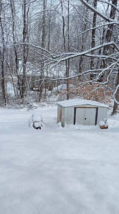
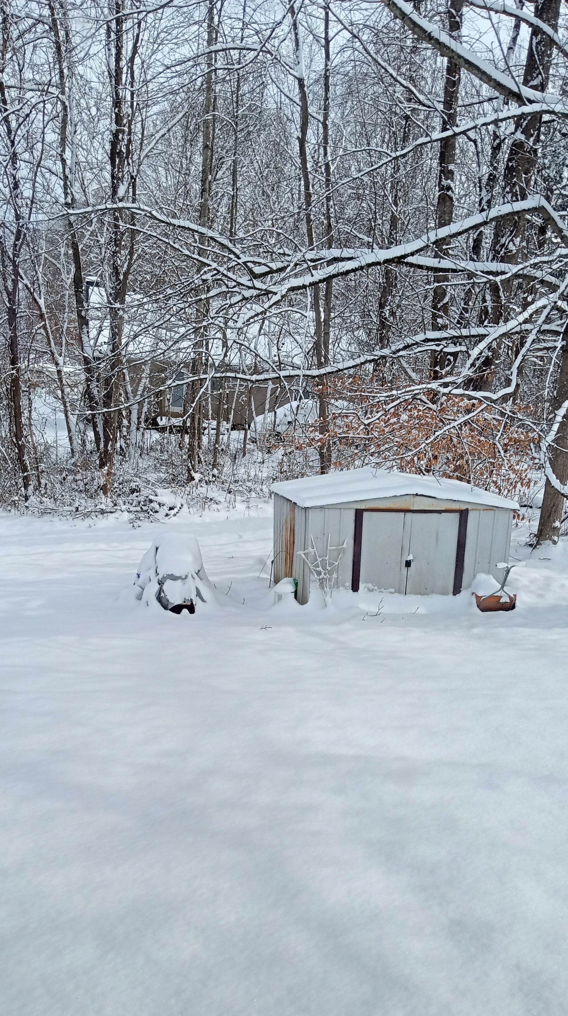
Out my back window. 7.2" Storm Total.
-
5
-
-
-
Totalled 7.2" with this one . All snow. High yesterday was 28.5. Low this Morning was 13. Currently 17.
Got official measured reports of 8 inches near Pennington gap and 7 in Dryden, eastern Lee County.
-
2
-
-
5 minutes ago, Carvers Gap said:
@Daniel Boone, I am going to put the response to your MJO thoughts. I didn't realize I was in the storm thread. Also, check out those temps in Montana from the last three days!
The strat split brought us this current outbreak and also likely this weekend's. We are going to need another one I think. I would suggest that the way that we have dodged warm phases in the past is with that set-up. I think winter returns(JB mentioned it today) due to that reason in part. Plus, I think the NAO will re-fire. I do think what looked like an early start to spring (March) is in serious peril if this warm-up has any duration.
Agree completely.
-
13 minutes ago, Silas Lang said:
Not really sure what to think of this one. Models showing rain, but with a thick snowpack and frigid air and more coming behind this system, one has to think we have shot a frozen precipitation regardless of what the models spit out. I just don't know how the cold can retreat so easily.
If they're seeing a strong push of mild air ahead of the System that's why. However, the entrenched lower level cold should spell sleet/freezing rain with still snow northeastern sections (upper valley) as cold from the valley lifts and mixes with the waa ahead of the system.

Cold Shot: Part Duex - January 18-20th Arctic Blast and Freezing Rain/Snow Event
in Tennessee Valley
Posted
Gfs holds and has Snow NETN/SEKY and SWVA. 2-3" SEKY and SWVA. 10:1 Ratio.