

Daniel Boone
-
Posts
2,098 -
Joined
-
Last visited
Content Type
Profiles
Blogs
Forums
American Weather
Media Demo
Store
Gallery
Posts posted by Daniel Boone
-
-
3 minutes ago, brooklynwx99 said:
you end up here on the OP... you're very quickly moving to a good to great pattern here. lots is in motion
Verbatim that's a major Winter storm for the mid South and Tennessee Valley if it is cold enough if that depiction came to fruition.
-
 2
2
-
-
1 hour ago, Vol Man said:
So, I saw this posted from Archives of Kingsport Facebook page. Winter of 1936 saw two huge snows just a few weeks apart, early February and mid March! Here are the newspaper copies they posted for those two events. Interesting references to some incredible snow totals around the area, and to the issue of phone lines still working. Also some pictures in their post.
archives of the city of kingsport - Search Results | Facebook


Thanks for posting that . Very interesting ! My Grandfather told me about a big Snow during the middle 1930's. I'll look that one up in our local Paper. The biggest on Record for here was March 2, 1942. 3 Feet recorded in downtown Pennington gap. I wish our Paper was online.
-
1 hour ago, jaxjagman said:
Should be out west not the east
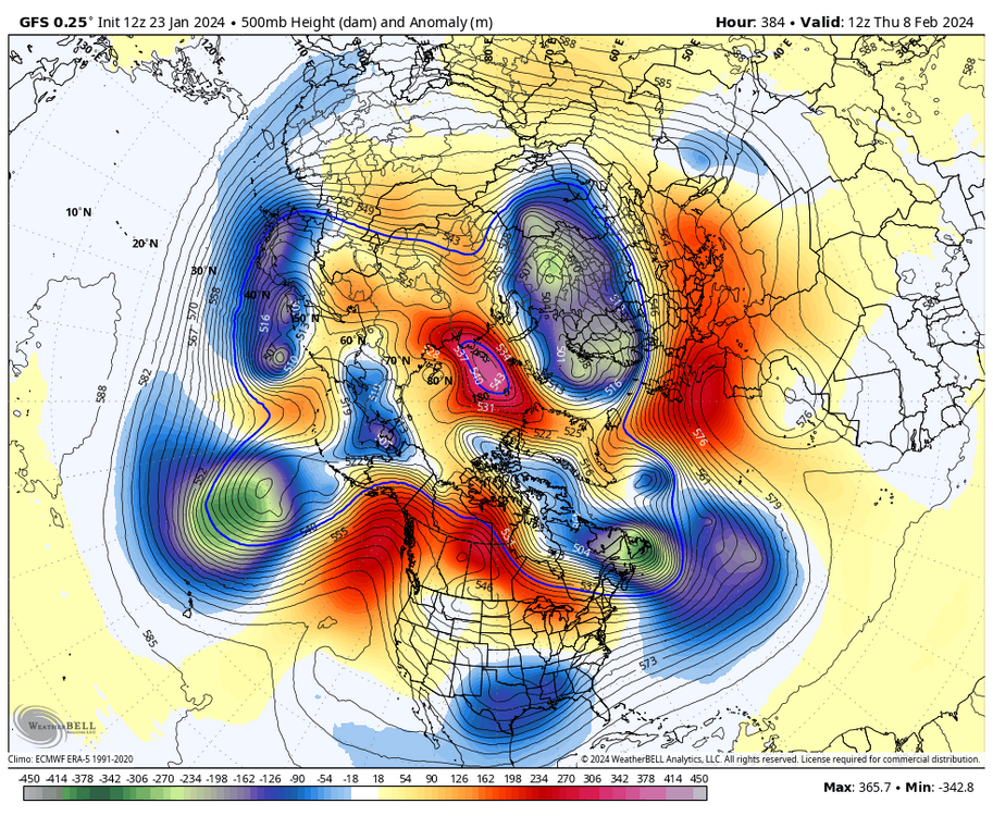
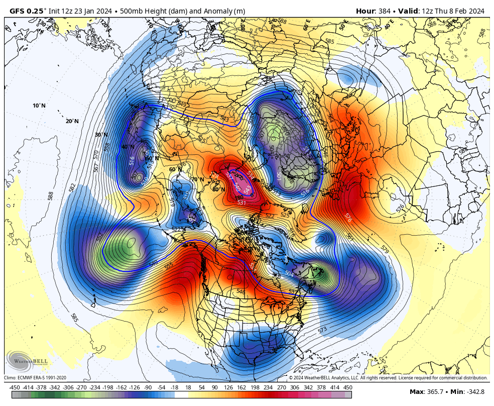
Yeah, greater odds as the plots show. Nothing like ph. 5 and 6 though. I think where he got that was a study and data GaWx recently presented irt the Southeast. The research showed the SE had greater instances of Snow during Ph 7 El Nino Years.
The STJ and typical blocking is more than likely the difference maker.
-
2
-
-
1 hour ago, jaxjagman said:
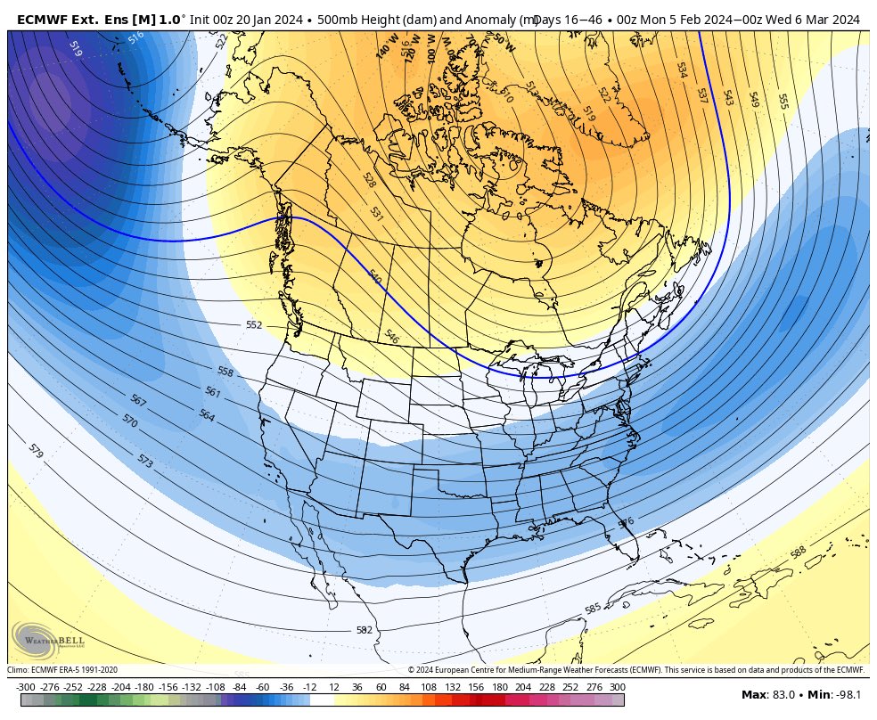
Guess ill give up on the MJO being more adavanced,it dont seem to have much support,the next 10 days the Euro ensembles are pretty much bunched up into the WP
.thumb.png.aa62d51dd84549f4b2b4d6b72be774c7.png)
Looking at what Holston pointed out I think the Model is in Error here. That central Pacific Convection should help change that outcome. Also, with it firing now, in my mind, that should mute the current MJO Phase some.
-
38 minutes ago, John1122 said:
Some of the issue is that they take snow depth at a fixed time every day and don't count snowfall that happens that day as snow depth. You can look back at records and see things like 6 inches of snowfall on January 15th but snow depth will be 0 or a trace etc according to what time the snow fell that day. Even in the chart Flash posed there it says 6.3 inches of snow fell on February 1st 1985 but snow depth is only one inch. I quickly found another day where it says snow depth was a trace on a day with 5 inches of snowfall recorded. Now I think snow depth is recorded as whatever the snowfall is that day, or close to it with compacting etc factored into the equation.
Exactly John. That is the way measurements used to be taken. If it fell at night they wouldn't measure until they got up or they'd wait as you said, until it ended. The average seasonal Snowfall for Pennington gap in the 1950 to 1980 period was 21 " . Records were recorded by a long time observer. He would measure like you said. They would also wait until snow ended too. If they were taken like they are supposed to be now, average then would have been 25-30" there.
-
1
-
-
1 hour ago, Wurbus said:
From MRX:
After yesterday's climate data, Knoxville has confirmed a 7th consecutive day with 4" or more of snow depth. This now breaks the record of 6 consecutive days during February 2-7, 1996 with data for snow depth going back to January of 1910.
Problem is, Data is not trustworthy. Going back through records there's quite a bit of missing data, particularly snowfall. I'd bet my life there's been times of many more days than that. I know Knoxville doesn't get Snow as much as up here but, they've had much longer stretches. The late '70s are a good case. I kept Records for my area in Lee County then and there was a period of over a month and a half of 6 inches or more on the ground in 1977-78. Well over a foot in shaded, north facing areas.
-
3
-
-
41 minutes ago, John1122 said:
Predicted low tonight was 14 but I'm down to 11.6 already.
They've forecasted too high for Temps every day for the last 5-6 days. As we know, Model's don't do well when there's snow cover.
-
41 minutes ago, Itryatgolf70 said:
Fwiw, Eric webb, who is usually decent with weather stuff, believes winter comes back earlier than we think. Around Feb 5th or shortly after. We will soon find out.
I saw that Tweet. He gave his reasoning too. Actually, has Merritt. Same IOD affects are different in February and March than December and January.
-
51 minutes ago, Carvers Gap said:
IDK. I lived in Knoxvegas during the 70s. I remember lots of snow. But being so young, I don't remember how long it lasted. It seemed reasonably frequent, but I don't remember it staying around for a long time. I do remember being out of school for long stretches of time. I would think '94 would have come close. That is the longest I have seen snow on the ground in Knoxville....frozen tundra.
We had a month and a half of solid snowcover of greater than 6 inches lin Pennington gap in the Winter 77-78. There was well over a foot in shaded areas and north facing slopes then.
-
2 hours ago, Carvers Gap said:
From MRX on social media...
Knoxville has so far confirmed 6 consecutive days with 4" or more of snow on the ground. This is tied with February 2-7, 1996 as the most consecutive days with 4" or more of snow depth with data going back to 1910. At our office, the same is true, but our data only goes back to the 1995-1996 winter. When looking at 6" or greater depth, Knoxville confirmed 4 consecutive days, which is the 2nd longest in the 114-year period of snow depth data. #mrxwx
I wonder how trustworthy their Data is. We all know how flawed alot of it is, in particular Snowfall data. I'm pretty sure Knoxville had alot more than that in the late 70's.
-
1 hour ago, fujiwara79 said:
For early February, The GFS keeps spitting out solutions that look more like mid April. Cut-off lows that spin around aimlessly in the Rockies, giving them a pasty wet "spring snow" while the rest of the country is showery. Looks like a spring pattern. Yuck.
With the Strat deal , there's going to be wonky solutions upcoming.
-
High yesterday 14 low this morning -3. Had reports if 5-10 below in the Valleys.
-
1
-
-
-3 morning low here. Several degrees colder in the Valleys.
-
5
-
-
1 hour ago, tnweathernut said:
This will work……..

Yeah, looks good.
-
2 hours ago, BuCoVaWx said:
I received 6 inches from this past system. 5 inches from the first. I believe this is the most snow on the ground since 2014. This will definitely be a memorable week of winter weather for quite a while. So nice to see snow everywhere. It feels like such a rarity these days.
Didnt you get blasted in February 2015 like we did ? There was over 2 feet on the ground in Pennington gap and Big Stone gap at one time. Over 40 inches fell in 3 weeks !
-
2
-
-
4 minutes ago, Bob Chill said:
2015 was only snowless south of the Mason Dixon. North of there got destroyed and there was a ton of arctic air floating around east of the MS River. Very different personality to this winter in general. I haven't liked any analogs popping up for early Feb. I'd like to see that change sooner rather than later but I have zero control of that lol
Yeah. Back here in far SWVA we picked up over 40 inches in a 3 week period starting Feb. 13.
That was the +TNH -EPO + NAO oddity. Record low of -20 on Feb. 20 th here.
-
1
-
-
10 hours ago, Stormchaserchuck1 said:
The first wave Stratosphere warming occurred Dec 25 - Jan 9th. This was, I would say a 3/10 scale warming. We did get the same kind of effects as the examples above of cold in the US +time, which we are still experiencing now, Jan 20th. -NAO occurred Jan 4-19, so a little sooner than my perfect correlation time.
Now we are seeing a 2nd wave Stratosphere warming, starting on Jan 13. It's so close to the last one, you can probably say the entire time is +Stratosphere warming, especially because 10mb never went below a 0 anomaly. It is rising and peaking now though, and on this latest map of Jan 17th: https://ibb.co/W5CDyQG
Average time for effect of this max period is +20 days at this time of the year, so the highest probability of NAO correlation is Feb 5-7, as of right now.
Here was the 1st wave 10mb warming final analysis: https://ibb.co/s1hYmTY US temps have looked like this since Jan 5: https://ibb.co/fM3YWKC (I'll probably do a +25 day final analysis when it's available, since that was the estimated time from when 1st wave occurred to effect.)
Good work Chuck ! The hyped heat wave may be muted to just a typical January thaw. Blocking will dampen the MJO if it's still in warm phases early February.
-
4 minutes ago, Bob Chill said:
Here, I'll throw ya a bone. 6z Gfs obviously figured out a jacked up way to get it done but not much needed here and it's a week away. GFS is right in the pocket of similar setups. Maybe one of the rain waves next week kicks the boundary east enuff to have more cold available. This window originally looked like rain to maine and Buffalo. Notsomuch anymore. The trough is going to dig and there are multiple waves ejecting. For now, it's still low prob/flawed but no chance models have timing figured out. If we have something to track next week it will soften the blow of what may be down the pike during first 5-10 days of Feb.

Yeah, definitely make it alot easier to handle. Really rooting for at least a 1-4 inch event before then. To add to your positivity , 2015 was basically snowless until near Valentine's Day.
-
11 hours ago, John1122 said:
Thought it may be nearly over but back to about 1/2 or less mile vis with fluffy quarters filling the air.
John, you need to become a Cocorahs Observer. We need Official Reports from that Area. KMRX would use your Rain/Snow Totals. Contact KMRX and they'll help set you up. May even provide an Official Gauge.
-
1
-
-
2 hours ago, Carvers Gap said:
The GEFS ext is beginning to show a similar look to what we have now....NAO is firing. I "think" that is the strat split doing its work. Feb 15 seems to be the date.
As for whether Feb can be a good month? When February is "on," there is no month better for snow. If there is ever a year for a portion of Feb to be good, this is the one. And honestly, some great winters of the past didn't even begin until Feb. With these past La Nina winters, we are used to Feb kicking out West and never coming back. This one might be different.
That's more like it.
-
2
-
-
4 minutes ago, John1122 said:
See that even Nooga is reporting snow from this. I know it's uncommon for it not to evaporate due to downsloping off the Southern Plateau.
Yeah, a bit more moisture than usual got entrained in the flow.
-
1
-
-
23 minutes ago, Carvers Gap said:
That big ridge at the end of the 18z GEFS out to do it....that is what should dislodge the TPV and is often what I see right before big changes occur at our latitude. Gonna take some patience. I suspect we see a massive winter storm(or two) along the eastern seaboard before we break for spring. It is a shame to have lost so much of December, but it is what it is. I do expect a quick start to winter next December. Hoping we can get a weak La Nina. If so, game on....
I agree. Yeah, many are gloom and doom for next Winter but if La nina is weak after Nino, should be good.
-
38 minutes ago, Carvers Gap said:
I will add that the massive wild card is the SSW. If we see modeling go haywire...then we know we might be back in business a bit earlier.
I'm in hopes that thwarts the MJO mess up. If it can bring back strong blocking that should do the trick.
-
1
-
-
9 minutes ago, John1122 said:
I'm getting quarter + sized flakes and probably 1/2 or less mile visibility currently. It's 18 degrees.
Had a squall go through about 45 minutes ago that dropped an inch . Total for the day of 3" now.
-
3
-
.png.e993878dddc60194ae40eaca30dc175a.png)
Jan/Early Feb Medium/Long Range Discussion Part 3
in Mid Atlantic
Posted
GaWx posted about how SE US Snow was more prevalent during Ph 7 MJO during Nino's. Probably something to do with the STJ and typical blocking during El Nino.