

Daniel Boone
-
Posts
2,098 -
Joined
-
Last visited
Content Type
Profiles
Blogs
Forums
American Weather
Media Demo
Store
Gallery
Posts posted by Daniel Boone
-
-
Bucowx posted those videos of April 1987 Snow Storm over in the Banter thread in case noone knows.
-
 3
3
-
-
2 hours ago, BuCoVaWx said:
Here are two home videos I have uploaded to YouTube of the 1987 snowstorm. Sorry if the quality is poor, I am certainly no camera man! Ignore my crazy daughter squalling in the background lol. The people in the videos are my uncle, aunt and cousin. Oh, and their dog "Moose" lol. According to my grandmother they received 34 inches when it was all said and done. I figured some of you guys might enjoy some never before seen footage of a great storm.
Appreciate it man ! Really great to see these from then!!!
-
 1
1
-
-
19 hours ago, BuCoVaWx said:
I have home video footage of this storm. I was only 6 months old, so I surely don't remember it. My uncle filmed a good bit of it. I may try to film a little onto my phone and upload on YouTube. Very interesting to see that kind of storm in April.
What is your YouTube channel ?
-
1 minute ago, Carvers Gap said:
I edited the Apps runner part...should read textbook Apps snowstorm.
I liked snow, even then. But I have to admit, that maybe was a bit much given that my entire spring break was stuck in the house. And yes, the snow was a paste job. Man, 54"?!?!?! That is insane. Yeah, I don't remember the run-up to that storm even being remotely cold at all. It caught everyone off guard.
There are a couple of Pisgah storms I am going to have to look up later. They were during the early 90s or late 80s. They may have been back-to-back. This spring kind of has that feel where a well-timed cold shot could cause some mischief. I wonder if we dig back through met records if we find an SSW lurking in the shadows of one or all of those storms.
Yeah, the morning of the day it started it was in the lower 50's here around 10 a.m.. The Front came through with just sprinkles. A rain snow mix began at 1:15 and fairly quickly turned to all Snow. It was all snow at start above 1500 Feet. It ended around the same time, oddly 3 days later. The Temp hung around 28-30 day and night during the period after it initially fell to that. Really unusual in so many ways.
The Pisgah Storm was late May of 91 or 92. I'm thinking nearly 5 feer piled up at the Summit .
-
2
-
-
5 minutes ago, Carvers Gap said:
This got shuffled to the previous page, but I encourage everyone to read about this early April winter storm, if not just because it is interesting. This is a storm that began w/ a slp in the Lakes (yep...a low in the Lakes), trailing cold front that hit the GOM, and a slp that climbed as an inland runner. Really, it is a textbook Apps runner that began as a wave along a strong cold front. That is one of the reasons that I watch strong cold fronts during spring.
Yep. Remember it well. Did have Pics of it. It started on Thursday the 2nd and ended Sunday the 5th. I took Pics each Morning of it. It was constant steady Snow the whole period. It was simply amazing. The LP did as you said and then got cut off from the flow and became a cutoff Low over the Southern Apps. It was raining in Detroit and Buffalo while snowing here. There was no drifting in the Valleys, just straight down Snowfall. I remember it being in the 70's for a couple weeks before that. So ground was warm. I remember sticking my hand through to the ground and it would be wet underneath. I had about 2 feet on ground at deepest near Pennington gap. A Neighbor had a junk car parked on North side of his home and there was 30" on it. WCYB reported a report from High knob near Norton of 54".
-
2
-
-
In regards to this area; while January turned out good overall, December and February have not. The Winter was much better than last for obvious reasons. However, looking back at past long term(30 Years) Averages, if we receive no more measurable snow the winter will be another well below Average Winter in the Snowfall Dept.. The Average for the 1950-1980 era for my location was 2 feet( If measurements were taken as are nowadays, would be even more). The next 30 was 20. Now, 18".
As of now my Total is 11.2". It'll take 7 " to hit Today's Normal. They used to change the "Normals" every 30 Years. Now, every Year basically. This actually masks the scope of how things have changed over the Year's for many as they don't either remember or look back at past Climate Data.
Some Data is now missing of which used to be there. That begs the question where it got to and even why. Alot of Data that is still there is flawed or have missing data within the Set's.
I am a retired Antique now, but, have alot of memory and experience under my belt having lived through these Climate Periods. I had my own Records for many Year's, hard copy and then Computer in these latter Year's. Unfortunately some were destroyed in a moving process and some a PC crash. I am thankful my Memory still serves me well.
I don't intend on being a Debbie downer or refuting anyone else's thought's/ feeling's irt this Winter but simply presenting facts mainly pertaining to my Area. The Reason Snowfall Averages have steadily declined is debatable. Some say solely AGW. Other's cyclical. I lean mainly SST location Anomalies. Sure, there has been a Global increase in Temps in our Lifetime but, not nearly to the degree some think or are saying.
Anyway, would like other's opinions/ thoughts. John, you have some data from your Local that goes a good ways back. Chime in.
-
2
-
-
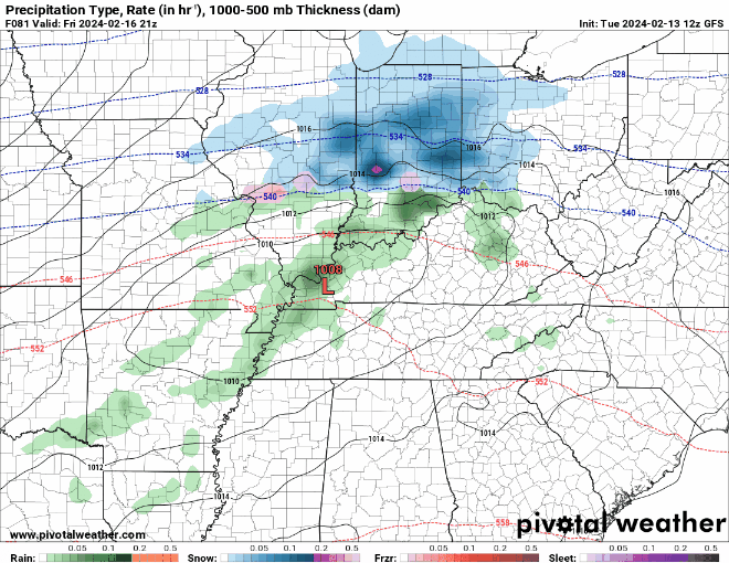
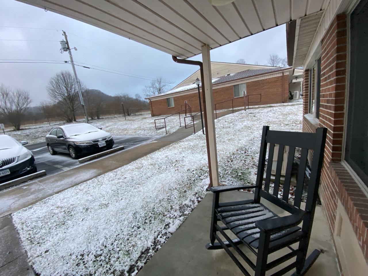
In Norton this morning.

-
4
-
-
12 minutes ago, Carvers Gap said:
Tropical activity can definitely mute temps. I think we might see some early tropical activity, a lulll, and then a tropical activity to end the heat during.....mid-late October. I would guess Nov-Dec would be seasonal to BN for temps before the Jan-Feb torch next winter. Though, I will say that if Nina is weak....it could be colder. I am still a bit torn on next winter. The QBO may be set to drop during later winter.
Yeah, next Winter is a bit murky as like you said, if the Nina is weak it can be a whole different ballgame.
-
1
-
-
Light Dusting here this Morning.
-
2
-
-
Light patchy Dusting here as well.

-
2
-
-
I'm with Carvers. Everything I see is pointing toward a hot, dry Summer. Imo, the only caveat may be if we're fortunate enough for TC activity to bring us beneficial Rains. TC development will probably begin early as Holston pointed out Factors arguing for a very active Season and the already very warm SST'S of which would favor that early start.
-
1
-
-
15 minutes ago, Jed33 said:
Yeah the GFS has been steadily increasing amounts for E TN, but can it be trusted. It doesn’t have much support at all from the other models.
Yeah, looking like we need a 50-100 mile further South Track according to most SRM's.
-
1
-
-
19 minutes ago, Carvers Gap said:
You are just gonna have to look out your back window and see it up the road if that verfies!
Yep.
-
1
-
-
1 hour ago, Jebman said:
Okay. NO severe canes in the Gulf. I will settle for a Hurricane Matthew hitting Mexico instead.
It'll then move on into Texas, lol
-
5 hours ago, fountainguy97 said:
You know... this is a couple ticks from a more "significant" flizzard.
18z followed South trend.
-
20 minutes ago, weathertree4u2 said:
Does that impact the lower 48?
Yeah, usually. Downstream affect.
-
2
-
-
13 minutes ago, snowfan said:

Short pump scores !!!
-
 1
1
-
-
2 hours ago, EHoffman said:
Maybe that's where Chuck's weird clouds are coming from???
Alien Spacecraft causing them.
-
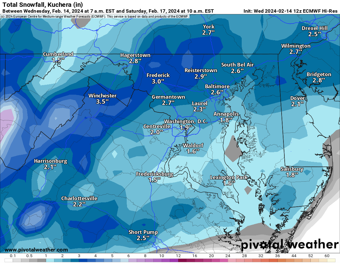
42 minutes ago, GaWx said:
In just 6 days, the GEFS AO forecast went from this on Feb 8th:

To this today: the forecast for Feb 21st has risen from -3 to +1, one of the biggest forecast turnarounds I can recall within just 6 days! So, it isn’t just the Weeklies that failed. The Weeklies failing isn’t unusual. The within two week ensemble timeframe (for all ensembles) has also badly failed, which is the biggest disappointment:
The NAO and PNA have similarly badly failed.
Yep. West PAC and IO SST'S.
-
1
-
-
31 minutes ago, eyewall said:
Yep the advertised change has all but evaporated. Don't worry we'll get in time for weeks of cold rain in April.
Pretty much guaranteed.
-
28 minutes ago, Carvers Gap said:
We definitely make our own weather. But there are a lot of micro climates as well. Holston's Sullivan abode is probably about 100 yards from my parents. (We have never met that I know of...small world though) I am a bit up the hill. On Friday's they test their stuff. Things shake. LOL. That looks like an industrial release. My original thought was aircraft chaff, but we really don't have a lot of that activity here. Plus, that looks like it is coming from a singular, stationary point. Make me think waste treatment which is about where that plume is. Ya'll, if I am missing for a few days, you know the black helicopters have shown up.
@1234 probably lives about 6-7 miles as a crow flies. Honestly, there are several Kingsport posters - I won't name all of them. I met @kvskelton(by chance)once when he was surveying in my neighborhood!
Was over your way couple days ago and thought about giving you a yell.
-
2 hours ago, Holston_River_Rambler said:
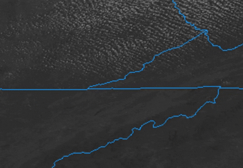
Ok, @Carvers Gap @kvskelton @Icy Hot and any other Kingsport adjacent folks, what is going on here:
Almost all those pixels make this look like it is coming off of Bays Mt, but a couple of frames show some hints that it might be coming from somewhere near Carter's Valley. We've seen this band during NW flow after storms sometimes, but today is unique.
Here is a zoomed in view with counties added:
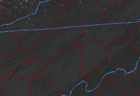
GOES 16 is so clear, I can see the point of Bays Mt there and Kingsport's urban sections around it.
At the little swag in western Sullivan county there is a swag, for lack of a better term, in Bays Mt almost exactly where that radar echo is streaming:

That is a tiny feature, but Im wondering what is going on up there to cause that radar echo under what is almost a totally clear sky to my eyes.
Wow. That's really strange. Hard to figure out.
-
2
-
-
5 minutes ago, Carvers Gap said:
It rarely fails us....thunder in the mountains. Just a wild rule that is probably more accurate than most weather models. Congratulations to everyone seeing snow. Pics or it didn't happen! LOL.
Yeah, pretty good boomers with that line that moved through around 9:30 here. Wind damage as well with Trees downed.
-
26 minutes ago, Carvers Gap said:
The Euro control weeklies lower the boom for the first week of March - SSW special right there.
Yeah, honestly think models are having a very hard time deciphering all the variables. SSW affects will most definitely alter the extended one way or the other.
-
1
-


2023-2024 Fall/Winter Mountain Thread
in Southeastern States
Posted
Yeah, shifted a bit North with main area.