

Daniel Boone
-
Posts
2,098 -
Joined
-
Last visited
Content Type
Profiles
Blogs
Forums
American Weather
Media Demo
Store
Gallery
Posts posted by Daniel Boone
-
-
1 hour ago, weathertree4u2 said:
What is the issue with the GFS retaining all the moisture around the gulf but never really meeting any of the colder air. Is there a reason why?
That's a puzzle really,tbh. Strong HP pressing can do it. I read something somewhere of a recent "upgrade" to the Model. Sometimes those can turn out to be downgrades unfortunately.
-
 3
3
-
-
1 hour ago, Carvers Gap said:
If the MJO didn’t look so squirrelly, I would roll with the Euro Weeklies today and say, “Extended winter is on tap!” But something feels off with this. I think it is going to be cold...but duration is sketchy. I do think a cold time frame from Feb 14 through the first week of March looks good. After that is what I am not sure about...if the Weeklies are correct, the Groundhog in PA is just a wee a bit off his game. LOL
Agree .
-
1 hour ago, wncsnow said:
So, when are the Ops going to start showing this great pattern? We are starting to get in better range and its looking like more of the same. Get cool for a few days, warm up, rain, get cool for a few days, warm up, rain.
This is not exactly arctic air day 9. So are we thinking February 20 or later? April?
.thumb.png.b9e4661a48ceef793e9081f098f3a24f.png)
Ensembles much colder.
-
1
-
-
4 minutes ago, J.Mike said:
I remember a March many years ago when we had snow every week in March. Does anyone remember the year?
1960
-
1
-
 1
1
-
-
14 minutes ago, BuffaloWeather said:
Here’s my channel. I livestream pretty much every lake effect snow event.
Subscribed ! I'll check it out.
-
1
-
-
46 minutes ago, BuffaloWeather said:
Watched storm chaser live stream of those. Lightning and thunder at times as well. Fun to watch !
-
1
-
-
3 minutes ago, psuhoffman said:
I think the extremely warm waters in the western pacific ran interference as the mjo wave propagates through. The spike and delay there was problematic because that forcing correlates with a positive nao.
But if we look at the winter as a whole perhaps we are on a 2010 type trajectory just warmer and displaced about 3 weeks later. Obviously we didn’t get a hecs from the first block but we did get two secs and snow on snow. The relax was worse due to a warmer overall thermal profile now v 2010 and the west pac issue but it’s following a similar trajectory and h5 pattern. 2010 was very high on my analogs list when I did the numbers. But no two years are the same. So it’s not shocking if there are similarities but perhaps this yea is warmer overall and the timing is a few weeks off.
The progression similarities to 2010 are pretty amazing. Also the way the SPV took repeated hits is similar.
The next 5 days looks similar in the progression to Jan 17-23 2010 with a southern Canada ridge and trough in the west and Atlantic


the similarities continue as the pacific waves start to undercut the ridge and it pulls north. This was Jan 23-27 2010


And the end result Jan 28-31 2010 and eps projected


We got lucky in 2010 that we got hit immediately with 2 waves before the Feb 5 Hecs. But I wonder if this year being warmer might be an issue if we get a wave around Feb 12-15. Then for a few days as the nao peaks we probably see suppression. But it’s not out of the question we get lucky again and something pops immediately but the best chances of a big storm if we play this progression out would be Feb 22-March 7. That’s when we would be in the period that correlates with Feb 5-Feb 20 2010. People forget we missed getting a third big storm by a cows fart later that Feb.
Great Post !
-
46 minutes ago, Carvers Gap said:
There is a pretty epic cold pattern on a lot of modeling....but the fail potential here, and I must warn you, is much higher than the mid-January set-up. But if the cold verifies...great pattern potentially. If it doesn't....that is just the way it goes. So, we wait.
MJO has been a thorn in our side more times than not the last several years. No need to elaborate as we all know the culprit. For the severe wx enthusiasts I'm sure they're rooting for the Emon depiction.
-
1 minute ago, Weather Will said:
Looks like by President's Day weekend we will have cold enough air again.... whether the Gulf moisture is suppressed or comes up the coast the third week of February we will have to wait and see. WB 12Z GEFS


Model's also will represent area's drier than average if precip is Snow for obvious reasons as we know.
-
3 hours ago, John1122 said:
The 1986 event. This is snow depth the next day.
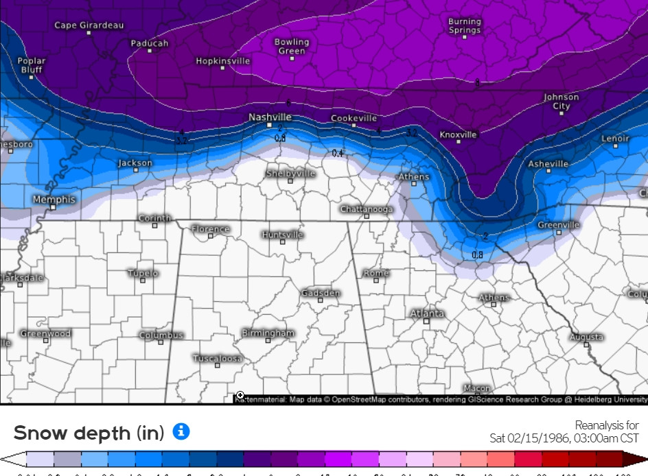
Definitely off here. Official Measurement of 13.5" Pennington gap. I took a couple pics my brother has in an old Album. I'll try to get and post those.That is what we recently discussed; the validity of snowfall records. Btw, that was the Storm that dropped 6" between 1 and 2:15 P.M. .
-
2
-
-
1 hour ago, John1122 said:
The snowline in 1986 was south of 40 in East Tennessee. It snowed 5-6 inches in Oak Ridge, Lenoir City, and at McGhee-Tys. By Athens and Chattanooga there was only a trace though. The highs south of 40 were around 35, along 40 around 32, and along the Kentucky/VA border, upper 20s. Strangely for the set up, it only snowed 2 inches in Crossville with a high of 33 on .70 precip. It snowed 6-8 inches in Fentress County just north of Crossville.
I don't remember it being a surprise though. Just that back them you went to school and if it started snowing, you went home.
Wound up with 13.5 Inches from that one.
-
31 minutes ago, Carvers Gap said:
Day 8-14 analogs:
19800207
19530209
19650228
19680207
20040209
19770211
19780216
19700209
19860206
20060207
Mostly good Analogues there. Some great one's.
-
1
-
-
2 hours ago, Carvers Gap said:
As noted over the summer, the Mountain West would likely see their best winter early. El Nino winters are no bueno for Montana and Wyoming. Cooke City, Montana, has bare ground showing and pavement on their streets is seen. Not sure I ever remember seeing that happen. That is a major hit for an area dependent on snow for snow machines. My guess is that drought will develop quite quickly for the summer, and that is not good news for obvious reasons. Again, I am a little careful as to how I word things so as it doesn't provide an easy search in a search engine for parties up to no good.
I check out the Cams pretty regularly out west and in western Canada. Hard to believe, Jackson hole had mostly bare ground yesterday. Canmore Alberta same deal as the Snow cover they had had melted. Also, many area's in British Columbia had lost much of their snow pack.
-
2 hours ago, BNAwx said:
We’re obviously heading into a mid-February to mid-March 1960 kind of pattern.

I wish…
Wouldn't that be something to behold!
-
2
-
-
8 minutes ago, jaxjagman said:
Yeah and the WWB by the Mean takes it back into the WP for a brief time,starting to have my doubts it gets cold around the mid month,not real cold anyways
.thumb.png.bd0e673545bd5ccbc6a903fa87677faa.png)
Definitely a fly in the ointment. If it just doesn't go back to 6 I think we'll be alright with the Nino and blocking present.
-
If the MJO basically hangs around 7 it could favor, as You mentioned, a further west mean Trough. However, with blocking that should extend that trough, at least at times, east . If we can get that -EPO and PNA Ridge the Trough would probably setup Rockies to Apps . Similar to last Arctic Outbreak area . With all that said, if you take into account El Nino Ph 7 then you get a further East Trough. So, interesting period upcoming.
-
3
-
-
Had a few slushy flakes mixed in when the rain started here earlier.
-
3
-
-
2 hours ago, NJsnow89 said:
What would it take to get the Eastern areas on the snow game lol
A cold Airmass in advance of the Storm.
-
59 minutes ago, BornAgain13 said:
Would love for us go start seeing better trends with this storm... DT apparently still thinks it's happening. He said it's game on lol. Don't know what he's seeing..
Sent from my SM-N981U using Tapatalk
Storm track, HP to the North and Upslope Easterly flow. Heavy Rates are a give with that Setup if realized.
-
 3
3
-
-
7 minutes ago, Carvers Gap said:
I think it repeats the mid-Jan pattern. It is not out of the realm of possibility that these temps will be colder vs the norm. The key is getting a storm to deepen earlier than later in the pattern. Modeling is probably not going to be able to spot that at this range. If I was wanting to possibly find a thorn, it would be the SSW likes to dump cold in Asia as a first choice. If I was going half empty, I would say we get the trough but no source region for cold. I think we will be good though.
Right with you in those thoughts man. Yeah, should still be plenty enough cold in Canada this go around. Eastern Canada looks loaded last I checked.
-
34 minutes ago, Carvers Gap said:
We have talked about the delay a bunch. Convection over the MC and convection near Darwin is the reason. When it fires, the MJO is headed for 6. Yes, it should move through 8. We are actually out of phase 6 today - fingers crossed that we say out. Modeling busted hugely by stalling it in 6 - it appears for now. The MJO has kept chugging along. Technically, it is in a colder phase now which is phase 7 during the MJO. There is a loop that may(or may not) occur which is the push back on surface temps on the Euro Weeklies. Trends right now are to move the MJO at higher amplitudes into 8, and earlier than prognosticated - this is important...I don't think modeling has responded to that phase 8 trend yet. Last time, modeling didn't catch that until around d10 - the mid Jan cold shot was missed by modeling as modeling seems to wash out MJO signals until inside d10. The intensity of warm wx was also caught late. I think we have also said that if this was similar to January, can kicking would be likely. It is very common for an eastern ridge to break down slowly as it is super stable. The pattern flip during late December was also delay about 5 days. That said, the 500 pattern is right on schedule. But just because we have a trough over the EC doesn't mean cold immediately dumps into it. In fact, I think this forum has been the most conservative in saying the cold would be delayed - Webber called for an early flip as did a couple of other mets. We have consistently said that the cold would not arrive until mid-month.
Interestingly, we are going to finish right around seasonal temps for January at TRI.
If KTRI had gotten the Cold that was just to it's west, would finish below average for the Month.
-
1
-
-
27 minutes ago, tnweathernut said:
JMO, but I think he's reaching even calling locations for a snow storm this far in advance. He's good, but I generally don't listen to him for our area (and especially the microclimate known as northeast TN). The biggest problem we will have this side of the apps is cold air. Would be incredibly rare to have cold "enough" air come down through the lakes and spill west of the apps. Cold air damming is a distinct possibility for our friends on the other side of the mountains. I think if this snow storm belongs to anyone, it's probably those guys (NC/VA).
Yeah, the Great Valley definitely has a tough time without CAA down this side of Apps. There have been instances of enough cold seepage down the Valley from the NE. However, usually that occurs with heavy precip rates helping bring the cold air down. A big banana HP to our North can get it done ala., the Spires depiction but, generally without alot of cold to pull down you need weak winds, low onset DP and quick uptick in Rates.
-
2
-
-
1 hour ago, Itryatgolf70 said:
The million dollar question is what is slowing the mjo? How will it be able to advance to the colder phases? I bring up the kicking can scenario because that's all we have to work with currently. Typically niños are backloaded but perhaps this one will not be. I believe it will get cold again, but probably later than most people believe or thought imo
Well, those SST'S in that area is the likely cause . However, that area has cooled some and we are seeing convection flaring in 7-8 eq. Pac area. This tells me the MJO will hit P8 and may even slow thereafter and probably traverse 1-2 at low amp or go into COD. Just my wag.
-
1
-
-
Got this from MA Sub. Not saw much about this Model but, check out that Feb 5 depiction.
The 0z SPIRE MODEL fwiw...

Sent from my SM-N981U using Tapatalk
Perfect for this area.
-
1
-
.png.2cbe43917b084922f14719bdbe21eb76.png)


.png.b8c129ad2f7fe150cbf758d2a9c7ae93.png)
February 2024 mid/ long range
in Tennessee Valley
Posted
Here's a very good research/study of February and March 1960 covering the Southern Appalachian Region. Click on Visit Site as it's in PDF Format.
https://images.app.goo.gl/yVE87S6UhpbiYWUe6