

Daniel Boone
-
Posts
2,098 -
Joined
-
Last visited
Content Type
Profiles
Blogs
Forums
American Weather
Media Demo
Store
Gallery
Posts posted by Daniel Boone
-
-
An inch of new snow here. May be a little more as it's blowing around. Parts of County a couple inches.
-
 2
2
-
-
10 minutes ago, MattPetrulli said:
Went outside, got a thin glaze of ice on the car. Probably will keep me home tomorrow. Pretty impressed with how widespread the freezing rain is.
Yeah, Hrrr got it partially right. Basically a blend of RGEM and it tonight. Hrrr had all freezing rain for here this evening. The RGEM all snow. We've had both.
-
2
-
-
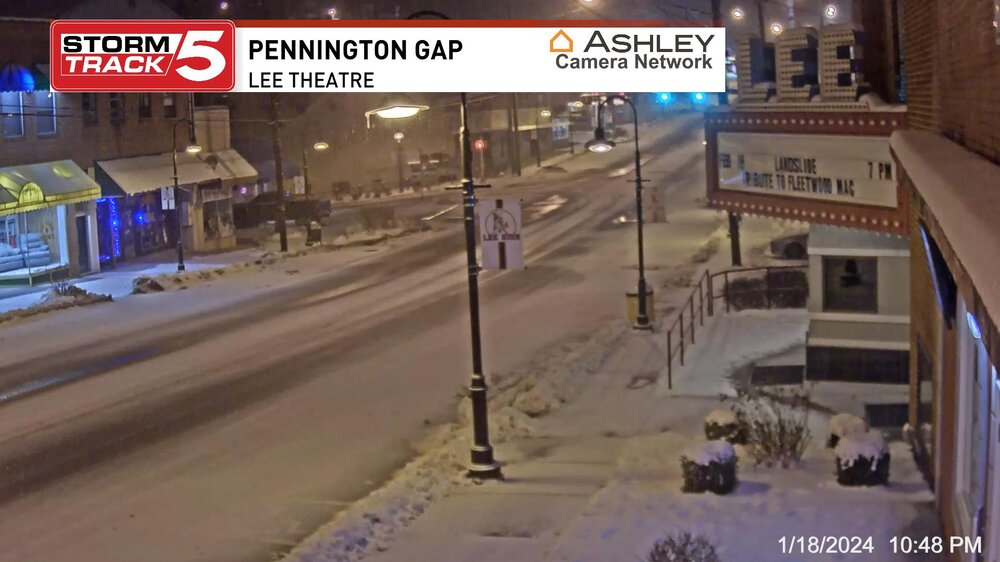
Here's Pennington gap Cam few minutes ago..
-
5
-
-
5 minutes ago, John1122 said:
I hope so. I believe there's issues with getting moisture to the dgz because we shift back to drizzle when it's not coming down hard.
It's that warm mid level layer. Heavier rates got through it and cooled that column. Apparently the waa stopped so, that midlayer is cooling with the mixing.
-
1
-
-
Steady lt to moderate snow here now. Had a pretty good period of freezing rain that iced everything over. Now have a coating of snow on that. Changed back over to snow about 45 minutes ago.
-
1
-
-
1 minute ago, John1122 said:
I've now switched to sleet and snow.
Good news. Hopefully enough cold above 850 and in lower levels that the middle lower mixes and cools enough to turn us all over to snow before long.
-
2
-
-
The absolute worst scenario for us. Extremely treacherous in every aspect.
-
2
-
-
Freezing rain sleet here now. Freaking HRRR may score one this time unfortunately.
-
2
-
-
Dierks on wcyb has 2-6" total for here.
-
1
-
-
A dusting from that small band. Quit for now.
-
2
-
-
Snowing here now.
-
10
-
-
2 minutes ago, John1122 said:
Switched over to sleet with an occasional flake. Temp is 31.
I assume the further ENE one travels from there the slower snow to sleet changeover or mixing . I expect mainly Snow and sleet here, all Snow Wise on NE.
-
2
-
-
7 minutes ago, Itryatgolf70 said:
Weaker niño then so I guess it is possible now.
The odd thing that time was the NAO was positive. There was a huge PNA Ridge, -EPO.
-
2 minutes ago, Carvers Gap said:
I like Feb 15-17 as a return to sustained cold. If it is earlier, that is a bonus! Otherwise, I think we get very cold last two weeks of that month and first week of March. The Euro Weeklies look very good in that regard. I still am hopeful for some cold around Feb1(quick hitter).
That would be akin to what happened in Feb. 2015.
-
1
-
-
30.1 here and overcast.
-
2
-
-
15 minutes ago, fountainguy97 said:
Down to 36.5 from 37.5. Clouds moving in saving our melting snow.
I'm interested in the cold push tonight. RGEM is significantly colder for NETN (especially my locale) than hrrr at 10pm. Considering hrrr was horrendous with temps earlier this week I'll go with the colder.
Yeah, HRRR has had a warm bias for this area as long as I can remember. You'd think that would be corrected by now. Alot has to do with what Stations data has been used and ingested in the Model's. If they're not calibrated well or are from a warmer location then it causes issues.
-
5
-
-
2 minutes ago, Carvers Gap said:
Interestingly, the CFSv2 seasonal has recently been less than enthusiastic about Feb. However, it threw this out this morning. If that is with a warm start for week 1, then that is signaling a pretty frigid second half of the month.
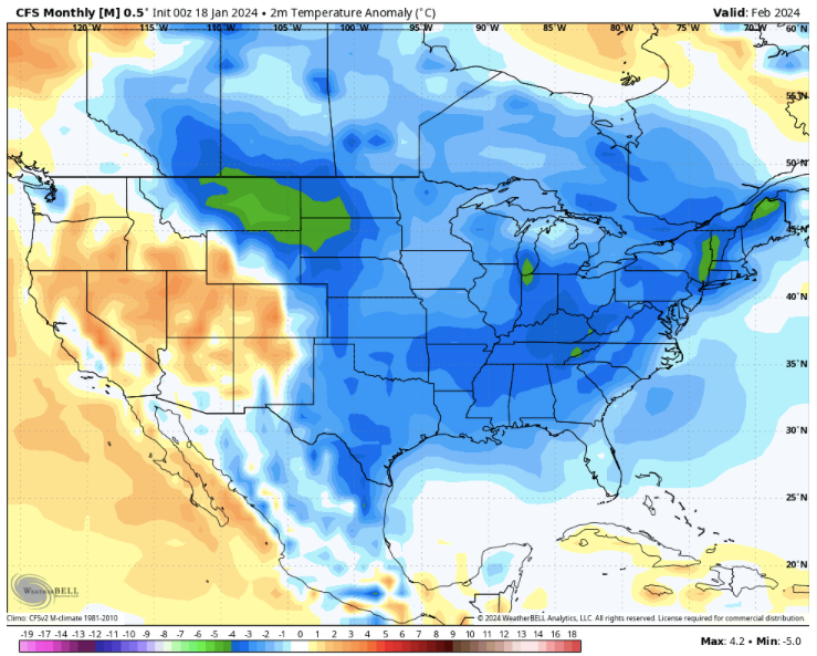
If correct, big dog opportunitIES !
-
21 minutes ago, Carvers Gap said:
Interesting. Yeah, I have never hated 7...but the CPC temp maps imply warmth here. I have always associated it with cold during later winter as well.
Yeah, I wonder what a ph 7 during Nino would look like.?.. Apparently, the enhanced STJ somehow throws the typical MJO alignment off kilter.
-
1
-
-
2 minutes ago, John1122 said:
I've made it to 27 degrees. I noticed the Crossville airport was at 33 but has fallen to 30. Dewpoints are low, in the 10s, so some wetbulbing will occur.
Yeah, could be what the more snow output Model's are picking up in. Low Dews.. evaporative cooling.
RGEM has this area with 2-4" 10:1 Snow Totals.
-
3
-
-
Larry in SE Sub and main Forum backed those findings with tons of Data.
-
2
-
-
48 minutes ago, Carvers Gap said:
Cosgrove sounded concerned this morning re: severe wx next week and heavy rain to our south. Said we should see a storm flip the pattern back cold if it can drive to a high enough latitude.
Jax’s MJO post last night is optimal. Boone is correct that warm-ups have been brief since Christmas. Jack has been money this year w the MJO.
If it gets to 8 we should then see a nice PNA Ridge set up. We really need those higher Lats in our favor as Coz was alluding to. That would help with the Southern trek and speed of Systems thus upping the ante of Big Dogs. If the MJO were to get stuck in the warm phases and blocking doesn't reset it could be another Flooduary.
We do have a wildcard at least . The SSW. It should revamp the blocking.
-
1
-
-
On a good note, it has became mostly cloudy here.
-
2
-
-
1 hour ago, Silas Lang said:
My fears look like they are coming to fruition. Ice, ice baby.
Oddly enough, the RGEM is actually trending the snow line into the central valley with limited ice the past couple of runs. Curious to see if the 12z holds. I want that solution to be correct! lol
Yeah, it many times has the winning hand here but, pretty strong WAA at 850 will probably give it to the Hrrr, or a combination of both Models may be the route it takes.
-
1
-
-
5 minutes ago, PowellVolz said:
I’m at 8 degrees right now. I’m afraid we got issues tomorrow unless WAA kicks in.
.Gfs holds and has Snow NETN/SEKY and SWVA. 2-3" SEKY and SWVA. 10:1 Ratio.
-
3
-

Cold Shot: Part Duex - January 18-20th Arctic Blast and Freezing Rain/Snow Event
in Tennessee Valley
Posted
Same here. Another half inch to an inch of fluff on top of the overnight inch so far today.