-
Posts
2,101 -
Joined
-
Last visited
Content Type
Profiles
Blogs
Forums
American Weather
Media Demo
Store
Gallery
Posts posted by Daniel Boone
-
-
2 hours ago, Carvers Gap said:
And again, the Jan 11-14 time frame has been lit as a warm week. And again, really the Jan 11-25 timeframe has always been pretty warm looking....having a cold shot in the middle of MJO warm phases is pretty much a bonus. The MJO "should" be prime by the end of January again.
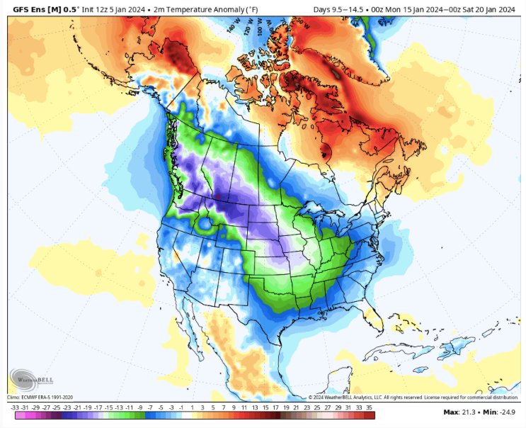
That's true although i'm always leary when an arctic airmass dives to Baja, that's why the earlier Post. Sometimes Troughs can get stuck back there for quite some time as we know. Hopefully, and by looking at other guidance, the gfs is wrong in that depiction for that timeframe. An amazing sight on there is that 989 bomb in the Rockies then ! What a Blizzard that would be for even that area.
-
 1
1
-
-
-
12 minutes ago, weathertree4u2 said:
Looks like we may have a chance at the end of the noon run of the GFS but we all know how fantasy land GFS is
Yeah really. Look how bad it looks before that. As mentioned couple days ago , you don't want a deep arctic airmass dive down the west coast. The PAC is killing us once again. Those warm WPAC and IO SST'S are the Root. Even the MJO hanging in the warm phases correlate. If only that Arctic Outbreak would drop down the Rockies and Plains. Whole different outcome then. As is, the more that dives down Californica to Baja, the greater the odds of what happened last year with the -NAO/SER hookup.
-
 1
1
-
-
7 minutes ago, psuhoffman said:
That ridge position into NW Canada with a TPV lobe in Quebec SHOULD mean that energy out west cuts under and slides east...but that has not been happening recently. We've seen this play out a lot lately. Everyone is focues solely on the upstream causes in the Pacific. But how much might the warmer gulf and atlantic with the TNH also be playing a part? Pumping the SER more than usually and adding downstream impediment to western troughs being able to slide east?
That what once was rare SER -NAO hookup has become a normal occurrence recently. Hopefully the GooFuS is just factoring in that outcome with this run and the GEM is correct. If not well.....
Edit: to add the that , I believe it still boils down mainly to the PAC. Ultimately, down to the extremely warm WPAC SST'S and IO. A deeply dug trough down to BAJA argues for an Eastern Ridge as we all know.
-
11 minutes ago, Carvers Gap said:
Just 1 dud in the whole package. 12-30-73 one. It was a Nina Winter however.
-
18 minutes ago, Carvers Gap said:
The 18z GFS says that everyone east of the Rockies better get their plumber on speed dial.
You know if what we discussed yesterday does pan out, man should be some big snows crop with that as well. Even if MJO warm phases do commence, super strong blocking should mitigate or override it as was the case during some great wall to wall Winter's, ie 77-78 . That January featured nonstop cold in the Eastern US as the MJO toured the warm phases. I'm thinking the following Winter did as well either in January or February.
-
 2
2
-
-
36 minutes ago, Terpeast said:
Thats what I’m hoping for - that the neg AO blocking overrides the MJO and gets cold over us, and when the cold relaxes, we get into the favorable mjo phases and keep blocking up top
Exactly. Right with you man.
-
 1
1
-
-
49 minutes ago, SnowGoose69 said:
I never know what to think about wave magnitude. BAM on twitter has argued historically he can find cases where insanely strong waves in weak Ninos through 4-5-6 did nothing negative to the pattern in the East and likewise where strong waves through 8-1-2 in big Ninas did nothing favorable but pointed out where a weak wave through 4-5 killed us in a weak Nino. I wonder if as some argue the MJO probably more often than not does not influence things when you have an ENSO event that is well coupled.
Good point. Some of the great wall to wall Winter's ie, 77-78 featured continued cold in the East during the MJO warm Ph Tour in January. Sometimes other Drivers apparently just override it.
-
18 minutes ago, beavis1729 said:
You can see the print of a bad PAC there. Also, what looks like warm ph MJO trying to kick in.
I never like it when the Arctic Airmass would dive that far west into S. Cal. Usually spells at least a semblance of a SER even with blocking. Also spells cutter's. We need that to drop down the Rockies and Plains. Front Range as John noted, ideally. Hopefully, this does drop down further East.
In the setup of a deep western arctic plunge along with a - NAO the SER usually pokes up toward the Valley, unfortunately.
You can get Cad due to the blocking so, east of Apps and MA can still fair well..
-
 2
2
-
-
2 hours ago, GaWx said:
The 0Z GEFS is forecasting towards midmonth easily the strongest Jan -NAO since 2011 and 2010. Both of these times, ATL and other areas had measurable snow with 2011 being major in much of the SE US. It is also forecasting a very strong -AO. In addition, it is forecasting a strong MJO phase 4 and moderate -PNA.
It's just unreal how we seldom get the MJO in favorable phases with a formidable -NAO .
-
 2
2
-
-
2 hours ago, Carvers Gap said:
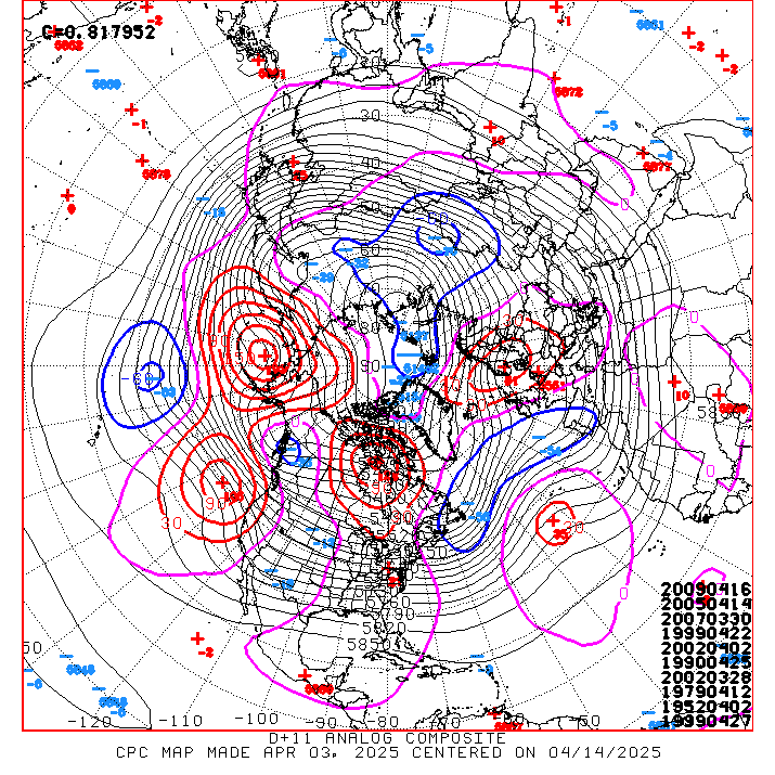
Day 8-14 analogs:
19590102
19680106
19960129
19620117
19850131
20040102
19811230
19681228
19710107
19940107
Many good Analogues there.
-
 1
1
-
-
1 hour ago, Knoxtron said:
Only other model that kinda supports it seems to be euro, no major short term model support.
Oh nam, you get me every time
Used to when you got the Euro and Nam in agreement it was a seal the deal thing. Not so much anymore.
-
 2
2
-
-
3 minutes ago, ShawnEastTN said:
Also critical to our region usually is having the regions north and northwest with some good snowpack. That hasn't really happened yet but looks like over the next few weeks might finally begin to start building. I have family in the UP of Michigan and they at Christmas had zero snow on the ground which is very very rare for them. Usually by end of December the Superior snowbelt region has a couple feet of snow on the ground already. For Detroit area in lower Michigan it's the second least snowy December ever recorded and among the warmest.
As I sit and type this it is snowing now suddenly at my house, looks like virga is trying to overcome the dry air. Not really snow but graupel.
Sent from my Pixel 7 using Tapatalk
Noticed radar returns were enhancing in area's. Graupel can definitely make it through that dry Column more than flakes. Maybe we'll get a surprise dusting tonight.
-
 2
2
-
-
3 minutes ago, Carvers Gap said:
And that is exactly what 18z looked like. I had a high of 12 on that run for a day.
Hopefully, it comes to fruition. Pretty good odds actually .
-
 2
2
-
-
32 minutes ago, Met1985 said:
I can literally smell snow. Them clouds have that milky look to them.
Yeah, clouds definitely snowy looking. If it weren't for the dry mid layer Atmosphere. Snowing in a broad area way up in Altitude. Virga Storm.
-
 2
2
-
-
3 minutes ago, Carvers Gap said:
I am good with weak Nina characteristics, and maybe we see some of that as this Nino collapses. The 18z is bitterly cold at d+10. That would be a great look.
Appreciate everyone as always. Great discussion!
Yeah. That's the thing. It could work better for us with a mix Nina/Nino Pattern. Nina more apt to promote Arctic airmass delivery via Polar Jet and Clipper's as well. Nino SJT along with Blocking. Enhanced possibility of a big Dog imo. If we can get that Arctic airmass down here as shown then , that should be when the real fun begins.
-
 2
2
-
-
34 minutes ago, Carvers Gap said:
Plus, the negative NAO isn’t due to fire untold Jan 11ish. I don’t think we will know the outcome of the pattern after that until it is in place. Models have been poor predicting NAOs traditionally. Does it hook and hold into the eastern ridge or does it force BN heights to its south which it should? I think we get a really good pattern.
I think the MJO is driving the bus for the next ten days and has been for that last 40-50 days. We see the consequences of the MJO as an EPO or PNA (or lack of)or the retracted jet(which its opposite probably was a driver earlier). Temps mirror the MJO right now very closely, and have been.
Yeah, I agree if we get that bridge we should be in business. I think the MJO is definitely involved with the pattern but, think it's having some substitute relieving it some. That Nina Ridge trying to establish into the Aleutians occasionally is being forced most probably by those SST'S aforementioned at least in Tandem with the warm western Nino SST Area. A typical Nino Aleutian Low , or even an east based GOA LP is being knocked off kilter.
-
 1
1
-
-
3 minutes ago, John1122 said:
After looking at it a bit, it looks like the EPO has been driving things to a large extent here. The few actual cool downs we've managed this late fall/early winter have coincided with it going negative. Often it will lock in negative when it does and truly bring severe winter conditions to the east. However, this year it's been very transient with 4 or 5 days in the negative and we follow with several days BN, then it rebounds to positive and we warm back up. A -EPO will overwhelm a -PNA and flood cold air this way. I seem to recall 2015 the PNA was negative in late Feb but the EPO was also deeply negative and we were 15-20 degrees bn with a lot of snow and ice as the EPO overwhelmed the PNA.
Exactly what's been going on. Bluewave posted recently in the regular Forum regarding that and his thoughts behind it. The Western Pac Warm pool is what he said and actually gave a pretty convincing reasoning. Many, Pros and Enthusiasts alike gave their argument in how the Nino should overcome that. Apparently, it hasn't. It probably is trying thus the occasional -EPO.
-
 6
6
-
-
2 hours ago, Heisy said:
We saw some step backs last night in LR, let’s hope that doesn’t continue at 12z
.Yeah, Model reflection of MJO warm phases projection along with Jet Ext..
-
1 hour ago, Met1985 said:
Yeah, with that strong -NAO the GFS should correct SE with those cutting Systems. May even do like the lumbering LP that hit central Plains with that blizzard a little over a week ago. It cut toward the MW then got shunted SE by the HP in Canada then.
That used to happen in Winter's of yore when blocking was in place. If one did cut it would get blocked and then have to travel SE under and around the blocking.
-
 2
2
-
-
3 hours ago, John1122 said:
The PAC NW is supposed to get 7-10 inches of rain and 60-80 inches of snow over the next 16 days. When you see that there, we're rarely going to be getting much in the way of winter weather, as it means a very hostile pacific.
Yeah, that's the case most of the time. Hopefully, the strong -NAO will ultimately lead to those Systems tracking SE and we get some hybrid Transfers ala 95-96. Phasing with STJ Systems would be the thing to watch with the Nino being around now.
-
56 minutes ago, Carvers Gap said:
Yeah, some guys in the MA forum mentioned the same thing(mets). I wonder if there is a model bias to cut storms during El Nino due to "model memory" from the past three years. IDK - just spitballing. If models "learn," they may have developed some Nina habits. Used to (I know you know this), we wanted a storm to the SE of us and it would trend NW. Now, I have no idea where we want it on modeling. The cutter after that....maybe that is where we want it! LOL.
Bingo ! I think you nailed there buddy.
-
56 minutes ago, pazzo83 said:
yeah my parents still talk about that storm (they were in Ohio)
My Uncle and Cousins lived in NW Ohio. They never get over that one. Amazing !
-
 2
2
-
-
54 minutes ago, Met1985 said:
Yeah the freaking NPAC is acting like we are in a Nina... It's frustrating as heck.
Exactly. Those super warm SST'S in the western PAC is the culprit I'm pretty confident of.
-
 1
1
-


.thumb.jpg.f57ea30a63c154b0fb6a65e69a44a25f.jpg)
January Medium-Long Range Discussion
in Tennessee Valley
Posted
Yeah, I hope front range. If so, going to get cold and probably snowy.