

Daniel Boone
-
Posts
2,849 -
Joined
-
Last visited
Content Type
Profiles
Blogs
Forums
American Weather
Media Demo
Store
Gallery
Posts posted by Daniel Boone
-
-
7 minutes ago, StantonParkHoya said:
An aside to the discussion but you’ve got to be a real winter wx sicko to hope for ice
Agree.
-
Just now, StantonParkHoya said:
If the sw didn’t get buried back into the Baja, we’d be in the game. It’s discouraging because it’s so so close.
Yeah, timing of it coming out did too but, larger synoptics plays a Part in that.
-
 1
1
-
-
1 hour ago, Met1985 said:
I think that we should just sit back and watch things play out. I know the trends haven't been great but a lot can happen from now and then. A lot of unknowns currently with the pattern. I'm still optimistic and it can just take a few runs to show something worth while.
What really hurt is what John and I touched on in the Tn Valley sub, The Western Ridge has nearly broke down and is displaced too far West . Models originally had that centered over the Rockies. That allows this System to climb further North than it would have west of us. If snow pack existed to our North the Baroclinic Zone would set up further South and the Storm would probably travel farther south and we'd still got hit as well. So, couple flaws fouled us up with this one.
I'm with you in still being hopefull.. Just not as enthusiastic of an old fashioned January, Winterwise, as I was.
-
2
-
-
1 hour ago, olafminesaw said:
At least our friends in New England aren't getting it instead

Not now but, they will later. No issue for them.
-
1
-
-
9 hours ago, John1122 said:
That run of the Euro was made of middle fingers for East Tennessee. 150 hours of icebox cold but tumble weeds blow through it's so dry. Then 33 and rain while North of 40/west of Cookeville get a huge snow where precip shuts of immediately once it drops below freezing in the East. Not even from a cutter either.
Yep. Product of what you mentioned earlier. Western Ridge Placement.
-
Just now, John1122 said:
The Pacific is such a headache for us, once again. The PNA is neutral now and that's what killed the weekend storm. Then the ridge orientation is bad and we can't take advantage of the northern stream energy.
Exactly. If that Ridge had stayed where it was originally projected we were golden.
-
1
-
-
Looking like at least another healthy Rain event for the area.
-
16 minutes ago, Carvers Gap said:
I was driving into the foothills outside of JC, and saw plenty of snow showers in the mountains. Looks like areas above 4,000' had snow on the ground.
Some accumulation above 2000 feet on Stone Mountain just north of Jonesville. Snowcover lowers the further west on the Mountain. Looks like down to around 1700 ft above Ewing in the White Rocks area of the Mountain. Probably an inch or so above 2500 there with a heavy dusting to half inch down to 1700 ft.
-
2
-
-
1 minute ago, TellicoWx said:
You guys along I40 and points north in eastern valley wouldn't let your guard down on system #1...last few runs keep taking small steps back south.
NAM is showing confluence shifting east with each run now though. If it's right, probably can chalk up it not coming further South. Had the Storm came sooner we'd got it. Had it came a day or so later , it would of been forced South by Canadian HP coming down and we'd likely been hit as well. Just bad timing for us.
-
23 minutes ago, Carvers Gap said:
12z Euro AIFS Miller A...heads to Hatteras right after this.
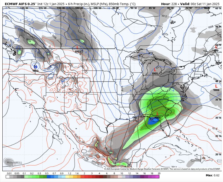
Euro Weeklies ensemble.
Euro Weeklies control...
If those ensemble depictions were to be realized about 100 miles further South than shown we'd be in great shape. Looks sorta like the highest expected averaged out area is inline with the Track of this upcoming Sunday System.
-
8 minutes ago, Buckethead said:
I like seeing this to our south this far out. It may play out like this, but it could very easily trend NW. I like our chances.

Sent from my SM-S908U using Tapatalk
The sad thing is, I've saw this play out like that quite a bit over my relic lifetime. One misses just to our North, the other South and then generally cold/ dry with a few flurries or dustings then warms up enough that the next big system is Rain. We wound up in the Screw zone those Winter's. The early to mid 70's come to mind. Hopefully, not the Case this time but , sadly looking like a possibility. On a positive note for you folks on that side of the Mountains, you all faired better than us during those times as the Southern Systems would graze you all and give some accumulation and Cad helped with the other some.
I
-
1
-
-
Some moderate to heavy snow falling here now . Not sticking as Temp is 35.
-
6
-
-
That GFS run was just terrible if you like snow in the Great Valley. More along the Gulf Coast . Kind of laughable in that it has St Louis getting about 4 Feet ! Knoxville getting hammered with a dusting.
-
 1
1
-
-
1 minute ago, John1122 said:
Just gonna hope for a few northern stream pulses after this likely cutter exits. Looks like the 2018 analog has a good shot at verifying.
Sure hope not but would be our luck. I'd rather no big system having come out of the SW and have 1-3 or 2-4" Clippers than have it come along and piss on us and dump North and NW of us while shoving everything way South after passing.
Hopefully we get in a Pattern that produces at least 2-3 Clippers from the NS after this debacle and the next way deep south Storm. If not, cold and dry until the pattern breaks.
There's still hope with this one. We need Canadian HP to drop down faster or the 50-50 to create more confluence and force the LP from coming all the way up to Tennessee but to slide East across Alabama and Georgia.
-
1 hour ago, John1122 said:
The ICON took a big shift south initially that run vs 12z, but rather than moving west to east like 12z, it runs almost due northeast and still crosses over Nashville like it did at 12z, then moves due east, transfers to the coast and dies.
Incredible warmth ahead of it. Mid-70s in Alabama. Doesn't seem believable to pump that much warmth up.
Yeah. Seems it's slower solution is causing it to estimate a bit of a SER pump up and pull up that extreme warmth.
-
2 hours ago, olafminesaw said:
On the one hand -NAO should continue to kick south. On the other hand, the last minute North trend is real. I think this map represents kinda the expected outcome with lots of uncertainty north or south. Of course plenty of opportunity for sleet or ZR south of that snow map
With a formidable block in place as is being advertised used to that would cause a shift South from 4 or so days before event until time of arrival providing the blocking didn't wane or shift away. So, hopefully the gradual south shift continues.
-
3
-
-
5 minutes ago, John1122 said:
It's a small tick, but 5 or 6 days away a few small ones mean the world in this situation. But the Euro was slightly weaker at 500 out in front of the system on the 18z run. It was a tick further south as a result.
Used to be with formidable blocking in place there was a South Trend with the Models within the last 3-4 days before Event providing the Blocking wasn't waning or moving out.
-
3
-
-
17 minutes ago, NorthArlington101 said:
18z EURO went south. I’d take it with the assumption this trends north as things tend to do, unless you think the EURO/GFS have finally found the exact compromise spot at Day 5.

With blocking in place( Greenland and 50-50) the last five days before event usually sees a South trend unless Block is fading.
-
1 hour ago, Holston_River_Rambler said:
Joy


There's that Ozark to Kentucky heavy snow zone.
-
2
-
-
1 hour ago, Carvers Gap said:
@Daniel Boone, the NYE analog package...Those are frigid.
19850119
19800122
19550125
20001228
20070125
19770120
19761229
19691231
19561230
19850124
Yeah, saw those earlier. One dud in there snow wise. 2000-01 .
-
1
-
-
One thing that has happened irt the 6th System in particular is the Ridge out West is further West and not very strong allowing the SW System to pull the Cold further west as well.
We wanted the Trough further west than what we had in early December and what was being advertised but, didn't count on it dropping down the Rockies and Southern Plains as looks to be the Case. A tad further East down the Plains/ Ms Valley with the storm either transferring to Gulf or moving ene from Louisiana/Mississippi area would be great. As it stands, it may alter the 500mb Structure.
With the MJO projected low amp 8 to possibly 1 it may not be enough to help if the structure gets off kilter from what we want and has been advertised so long. Could be what the EPS is "glitching" on . Just a wild arse guess.
-
4
-
-
1 minute ago, John1122 said:
Oddly, the GFS was the first to start the cutter parade. Let's see if it's first to the suppressed parade.
It's wild to have a decent Pacific and the -NAO and still have a cutter.
Yeah, hopefully something akin to a March 9-10 1960 Track and profile will manifest. Now, that would be a true Winner . As you know, that's part dream but also some possibility with the Setup.
The UK has the System probably coming at worst timing as a little sooner, more cold in place or a little later and canadian high surpresses it. That's how it looks to me.
-
1
-
-
8 minutes ago, BNAwx said:
I’d hate for a miss to the north, but snow cover to the north and west of us might help with future systems if we can keep the favorable pattern in place.
True. The concern is there too that the first one dumps to our North while the other's dump's South. I've saw that disappointment a good number of times. One of the Reasons I'm rooting for this one. If we happen to luck out and get it, at least we'd gotten a good one bagged.
-
1
-
 1
1
-
-
3 minutes ago, wncsnow said:
The UK is even further north for the first wave.

Yeah, the worst scenario. Chicago to Detroit Blizzard.
-
 1
1
-


Mid to long range discussion- 2025
in Southeastern States
Posted
I'm pulling for you guys over there. I hate when all around gets snow and leaves an area in a void.