

Daniel Boone
-
Posts
2,101 -
Joined
-
Last visited
Content Type
Profiles
Blogs
Forums
American Weather
Media Demo
Store
Gallery
Posts posted by Daniel Boone
-
-
31 minutes ago, John1122 said:
As expected, the Euro took a big shift north.
Yeah, that OV Lp. Started to mention earlier that I bet we'd have to deal with that when the GFS went South with basically a Miller A. Puts us in the screw zone.
-
39 minutes ago, Carvers Gap said:
It might get to SE TN. It would be a reach on my part, but there is still plenty of time for that.
Yeah true. Wouldn't it be a slap for the great Valley to get missed to the South and then North. Wouldn't be a huge surprise though as has happened quite a few times, even EWSN , lol. So's the life of those living in the Great Valley.
-
6 minutes ago, Carvers Gap said:
The 12z ICON has it as well for next weekend. You know, I am not sleeping on the Thursday system. The ICON has a mix for SE areas of the forum if I cam reading the green/blue combo correctly. A slight tic northwest, and those areas could score.
Yeah, looks like northern Alabama and Georgia may score with that one.
-
Hopefully we can get that clean Miller A southern track with stronger hp to the North. It's always rather worrisome, particularly here in the great Valley, when there's not a very cold Airmass in place. Also, definitely don't want a strong storm to our South with just marginal cold for it to pull down as that would result in stronger wind thereby enhaning downsloping.
-
1 hour ago, PowellVolz said:
Remember that one well. High ratio here as Temp was around 20. Measured 7 inches.
-
4 hours ago, Carvers Gap said:
88-89 was probably the first winter when I knew that winter was changing, and summer for that matter as well. Having grown-up during the 70s and 80s, 88-89 was ok for a winter...but the very late start(flirted with a non winter for a time) and following very warm January were pretty big red flags in hindsight, and red flags even then. I remember asking my dad if winter had changed. Again, as I noted in my response to John, I would gladly take that winter today. Then, it was pretty meh.
But I originally misread the analog as 89-90.
At the time, the 88-89 winter also followed a wicked hot stretch of summer at TRI. So, even to the modest weather follower, things were "off" that year. I remember, up until recently, that summer as being the hottest summer of my life. It wasn't the averages that were off, but the multiple 4-5 day stretches of 95-101F temps that were rough.
Yeah, Summer '88 still holds the Record for hottest I've ever recorded. 101. The extended stretches of extreme heat as you mentioned were unreal!
-
5 minutes ago, John1122 said:
Feb 1989 was cold and snowy here. It has an early cold/wintery period, a warm up and a frigid and snowy close. We ended the month was just over 13 inches of snowfall. We had a 3 inch, 2 inch and 7 inch event over the last 10 days of the month. We were roughly -3 for Feb even with a major mid month warm up.
Yeah, that was the only good Month of that Winter. You outdone us here by about about 3 inches. The end of the Month one was the biggest. I think it was the 25th. 5 inches here . Would have been an inch or two more were not for it sleeting over an hour at the beginning. Ice pellets that mounted to about half inch. You probably had all Snow with that one.
-
 1
1
-
-
3 hours ago, fountainguy97 said:
NAM'd
Hope that comes to fruition. It would make it easier to handle the cutter next Weekend. Carvers made good points regarding it . It could pay dividends afterward.
-
3 minutes ago, Carvers Gap said:
And you know, there is more. Euro Weeklies and CFSv2 for fun.............I will trust that you will look at the stamps to see the duration.
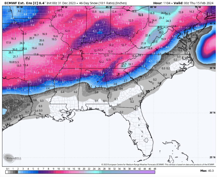
That EC Ensemble 500 depiction is very close to Ideal.
-
4
-
-
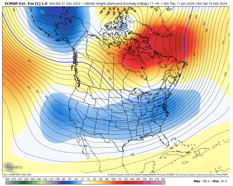
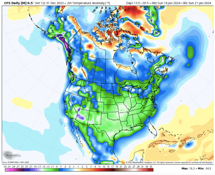
I buy into the Arctic Airmass coming into the lower 48. Not typical for a strong Nino but, with a rather Nina/Nino hybrid Pac Pattern to coin it,along with a strong -NAO and AO very much possible if not probable.
I am rather saddened by the nw turn in the early Jan big Storm. Really not surprising though. Need a HP dropping down from the N or NW to keep that thing from doing that. A banana High would do the trick but, doesnt look to be a chance of that happening either.
-
1
-
-
32 minutes ago, wncsnow said:
Well I haven't seen measurable snow in 2 years. It makes a man crazy
Here's hoping the weakened TPV will allow for a strong push of Arctic air into the Central/Eastern US thereby causing a STJ System to dump on you.
-
1
-
-
45 minutes ago, WinterWxLuvr said:
Shooting west of the Apps seems definitely on the table
Yeah, trending that way. Appears to be a weakness there up the eastern OV.
-
38 minutes ago, TellicoWx said:
12z GEFS screams model chaos after the first system...will be very hard for it to determine where/how to interact with this many lows parading across the country.

Yeah, 12z GooFuS has that System coming way North. At least CMC, UKMET still look good. Hopefully we get more HP to the North. The close proximity of the Lows hurts as it doesn't allow cold to funnel behind them. That can be a problem with Nino's. It does generally keep one from becoming strong and amping. However, the GFS has that first one a strong one and amping.
-
1
-
-
1 minute ago, wncsnow said:
Ensembles are trending north too
Yeah but, as far as overall pattern compared to just a few days ago. Honestly, I hadn't looked at the 6z so yeah, that trough coming into the west sooner doesn't help matters. We need to get a true Nino augmented NPAC Aleutian LP. The -PDO is hurting . Mainly the extreme WPAC warm SST'S are what's appears to be causing the problem imo. Wants to force a Nina like NPAC.
-
1
-
-
9 minutes ago, wncsnow said:
Models are trending worse and worse for the next 2 or 3 systems. Lots of rain even for higher elevations. Punting until January 20 may be a real thing.
Ensembles look better first half of January. Operationals are going to spit out different solutions often .
-
2
-
-
2 hours ago, Carvers Gap said:
LOL. Of course....
But for sure the least common denominator gets placed into the record about 90% of the time regarding snowfall. Now, there is no arguing from me that the last three years have been less during January and February for TRI. La Nina climatology(moderate or strong) is just a beast for TRI, and not in a good way. Now, December snows for the last 15 years are way, way up for me. This year didn't really have that, but the early, intense cold is reminded me a lot of 89-90. The problem is that snowfall averages IMHO are going down at a faster rate than they should be for TRI. For places like Chattanooga and Atlanta, the 10 year averages are probably more accurate. Now, the Plateau westward have had banner winters prior to this last one.
My plant hardiness zone has changed bizarrely after last December pretty much killed every plant and shrub that was on the "edge" of the old zone. Interestingly, in central Florida they used to have loads of orange groves. The climate supported them...until it didn't. During the early 80s when I lived there, the groves were wiped out by severe freezes. I still don't think they can survive there without huge financial risks. Now, due to population growth and financial risk, one would be hard pressed to find the density of orange trees that once were in that area. I remember, after the freezes, seeing dead orange trees as far as one could see.
Yeah agree 100%. Southern Plains and Mississippi Valley Snowfall averages actually went up the last five years.
-
Carvers, of course that's just a conspiracy theory from us regarding the political agenda, lol.
-
1
-
-
Just now, Carvers Gap said:
Yep. 14-15 was a winter where I also noticed data missing. I recorded almost 30" at my house, and I live in the bubble at lower elevations. But I know this, the snowfall maps made for TRI snowstorms(after the fact) are almost always underdone by 1-2" of snow, sometimes more. I used to correct the maps, but have since stopped. It isn't worth my time.
Yeah, I noticed that too. I wonder what they show for Lee County that Winter. ?. The range was 35 to over 50 inches (excluding Mountain tops).
-
1
-
-
1 minute ago, Carvers Gap said:
My response should probably go in banter. Considering I have had a White Christmas two of the last for years(rarely had one as a kid), I generally don't sweat things too much. I also know beyond a shadow of a doubt that there is data missing from the 95-96 winters and others. I have also seen snow taken out of recent reports(my own reports discounted). I have screenshots of my conversations w/ MRX, MRX's own graphs which show the 95-96 snowfall, and an M next to days(on the record) where it snowed. The snow record at TRI is as corrupted as any I have seen. Honestly, it makes me angry to see what has been done to it. I generally have to rely on @John1122's records (he is about 150 miles west of me and at a higher elevation). I don't know if it is political or just poor records keeping by past individuals. And MRX has some great, current mets...but someone has taken out snowfall data and won't record bigger results during even the most recent storms.
I'll second that. Same with the so called official Pennington gap Site. It's just awful how poorly recorded and kept the Data is. It may not be political but, it looks it regardless. Climate agenda .
-
1
-
-
Wound up with about half inch Total Snow here. Only a quarter inch or so on grass and snow board at any time however.
-
2
-
-
1 hour ago, Carvers Gap said:
Complex for sure at this range. The complexity itself likely means it changes many times between now and the event as you all noted.
I'll take a stab at it. Weak low pressure - almost a lee side Plateau low. Probably is a handoff to the Piedmont/Coast. Downsloping city right there. Air gets compressed, heats up, and we get warm air on the west side of the Apps...and less precip. Add in some warm nose, and you get that look. On the west side of the eastern valley...cold air gets pushed by counter clockwise flow up against the Plateau. The cold has nowhere to go. Th precip rises through the cold air, further cooling the air column, and you get rates induced snow. I have seen nearly that exact setup during ice storms. I have had 30 degrees at TRI, and 40 in JC/Unicoi.
Saw similar outcome in the big Jan 2016 Storm. Heavy Snow west and east of the great Valley. Mixed mess Valley. Wound up with just 4 inches at my house then. Oddly, portions of the County easily doubled that.
-
30 minutes ago, Met1985 said:
Just looked out and everything is covered in a blanket of snow. At least it looks like winter lol. Temp at 28.
If this developing stuff in far SWVA/EKY and NE TN move that way expect more than forecasted.
-
3
-
-
46 minutes ago, Carvers Gap said:
LR discussion(brief)....extended ensembles are most definitely sensing the crawling MJO(in warm phases) after mid Jan. We need a counter(block) to that where the NAO doesn't hook into an eastern ridge. We need the trough to slide under that block and hold on. If not, going to be very difficult to get winter to return with much meaningful time left on the clock. That is not a winter cancel post(for after Jan 15th), but more like a special weather advisory with the potential for a watch to be issued at a later date.
Yeah, was checking out the MA Sub earlier and they're pretty torn up regarding that. The GEFS is the terrible looking one. We can work with the other's. We definitely don't want that La nina Ridge dig that western Trough like GEFS indicating along with a - NAO. Then we have what killed us last year. Hopefully, that doesn't happen. Let's hope we score a couple times early January that way it'll be easier to take.
-
1
-
-
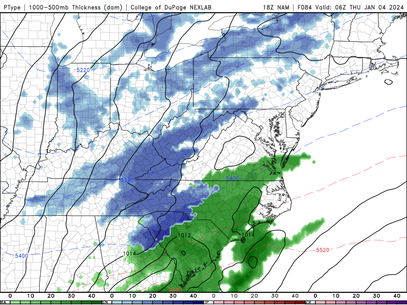
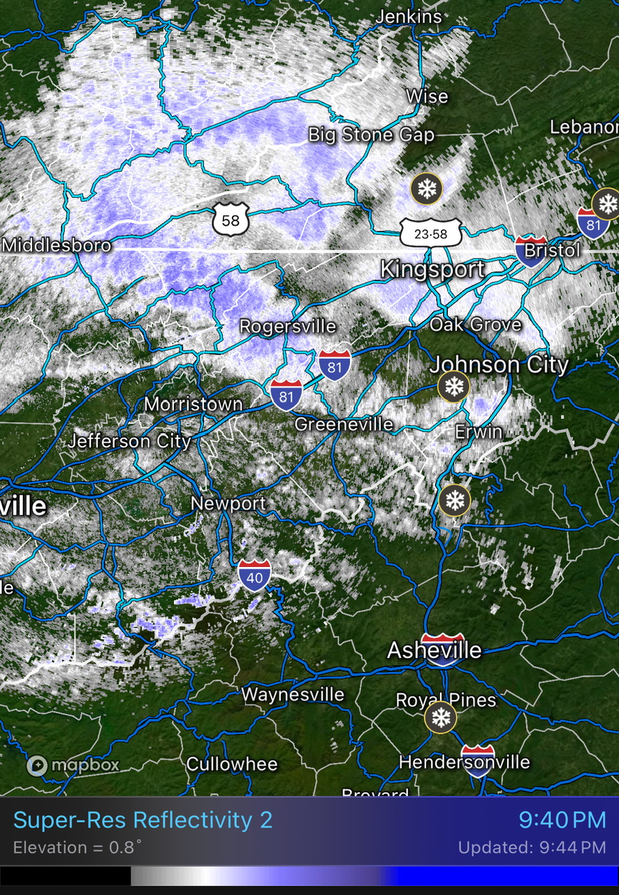
13 minutes ago, fountainguy97 said:
Man those streams of moisture building on radar the last few frames look stout. If we can get down to 32 this will stack on quickly. I've been hovering between 32.5 and 33.5 all day.
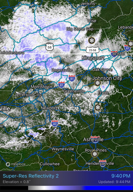
Yeah, a heavy shower quickly covered grass here. Looks like western Lee down through Hancock County is getting clocked with a strengthening training band. Also , area sinking south through Harlan County KY is moderate to heavy. Some areas will get a surprise accumulation tonight.

January Medium-Long Range Discussion
in Tennessee Valley
Posted
Yep. Living up to it's name for us.