

Daniel Boone
-
Posts
2,101 -
Joined
-
Last visited
Content Type
Profiles
Blogs
Forums
American Weather
Media Demo
Store
Gallery
Posts posted by Daniel Boone
-
-
Snow began here around 10:30. Temps running just above freezing so not sticking as it's not heavy enough to overcome the slightly above freezing T and warm ground. A dusting is at mountain around 2000 ft and up so far.
-
 1
1
-
-
Lt Snow began here around 10:30. Temps running just above freezing so not sticking as it's not heavy enough to overcome the slightly above freezing T and warm ground. A dusting is at mountain around 2000 ft and up so far.
-
1
-
-
Light snow began here around 10:30. Temps running just above freezing here. 34 now 33 at onset. Looks kike a dusting on mountain from 2000 ft on up so far.
-
2
-
-
2 hours ago, PowellVolz said:
MRX zone forecasts sometimes make no sense at all lol…for my location.
“Friday
A chance of rain and snow before 5pm, then a chance of rain. Mostly cloudy, with a high near 42. Southwest wind 5 to 10 mph. Chance of precipitation is 30%.
Friday Night
A chance of snow showers before 8pm, then a chance of rain and snow showers between 8pm and 9pm, then a chance of snow showers after 9pm. Mostly cloudy, with a low around 33. Southwest wind around 10 mph. Chance of precipitation is 30%.
Rain/snow on Friday changes to all rain after 5pm (lol)
Then at some point before 8pm it’s all snow but then Rain/snow between 8-9pm.
.Yeah, sadly not a very professional forecast at all.
-
1
-
-
2 hours ago, PowellVolz said:
Just found out I’m getting off a 1/2 day tomorrow. I might head towards the plateau or maybe the Cherohala Skyway in Monroe Co.
I’ve got a Jeep Wrangler with 35/12.50’s. It’s pretty incredible how well it handles in the snow.
.Nice Toy !!!
-
1
-
-
41 minutes ago, psuhoffman said:
Ops are really amplifying the long wave pattern. One problem with that is the pacific wins in a route. I’ve brought this up. Recently it takes weeks to establish cold and the first time the flow goes zonal off the pacific it gets obliterated in 24 hours!
In fairness it is cold before and after that period you posted but that’s a disappointing development if it does evolve that way and would likely mean we’re waiting until after the pac progresses again towards mid January. By the time we are getting cold enough a temporary trough off the west coast immediately obliterated all the cold and we’re back to square one.
Look I’m trying to be positive. But I’ve left it hanging out there that fail is an option and if so we have THE answer we’ve been beating around for years during this current pac cycle. Even if it goes down the gfs op way I suspect it still progresses to a good look after. But if this cycle of “flow off torched pacific obliterated cold in 2 seconds after a week of trying to slowly build a colder profile, rinse repeat” continues all winter at least we have the answer. This winter will be productive one way or another.
Yeah, Bluewave will look like a genius.
-
7 minutes ago, Ji said:
the canadien is worse

Could be Strat goings on messing with the Models.
-
1
-
-
2 hours ago, Terpeast said:
IAD got 10” with that Jan 1964 storm
Mood in this thread seems a little better now. I was afraid to open it this morning!
Sounds like me sometimes, lol.
-
34 minutes ago, *Flash* said:
I'm rooting for the 3k to verify. Just seems too bullish.
Much of the moisture in the mid/ upper levels was used up with last System , as KMRX noted. However, alot of low level RH so, may be picking up on that being lifted.
-
4
-
-
9 minutes ago, Carvers Gap said:
@Holston_River_Rambler, were global ensembles even colder overnight? Looked to me like a ridge rolls through on the ~9th, and then a colder air mass right after that. The CFSv2 (I used that to extrapolate past global ensembles) has a warm-up and then brings temps almost twenty-five degrees below normal for early Feb. I think that must be the strat warm effect.
Yeah, as most of us know, an SSW really fouled us up just as a great pattern was setting up a couple times the last several years. Timing of occurrence I suppose.
-
1
-
-
1 minute ago, PowellVolz said:
We did very well the last 48 hours. Well over an inch around Knoxville.
.Wound up with just over a half inch Total here. Totally short changed. Those bands continued training S to N over same areas yesterday. When that one that soaked the plateau finally slowly made it over our area there wasn't much left of it.
-
2
-
-
9 minutes ago, Carvers Gap said:
Great points. After reading your post, I pulled yesterday's 6-10 day analogs from CPC and the day 8-14. The first set are d6-10 and second set are d8-14. Interesting to see January of 85 in there. I don't think we see that type of extreme, but interesting to see it in the analog package for d6-10. I didn't expect that.
19881217
19570101
19661228
19810106
19770102
19550112
19640113
19850106
19870114
19550120
19670102
19640113
19890105
19881228
19790116
19550115
19570105
19760103
19701224
19600108
Alot of winner's there. Surprised to not see '78 . The MJO phases were similar is what was intriguing with Jan. that year. Cold/snowy through those. I don't know if MJO is used in those packages.?. I see quite a few Nina and Neutral Enso in there as well. Those '60's one's were great as was '71.
I'm with you on the extreme like '85 . Even if that pattern were carbon copied it wouldn't be as extreme as the Climate is a bit warmer now. That 77 wouldn't be as extreme either, obviously. Of course, would still be some cold stuff.
Some other's in there that featured a turn to colder but, didn't yield much Snow. '88-'89 looks to be too with that. It was rather lackluster sadly. Only real decent snowfall was late February. 25th I think. 5-7" from a storm that started as sleet(ice pellets).
Most of those on the list featured were good Snowfall wise.
-
5 minutes ago, Carvers Gap said:
This is Part 3, and the final of my series of posts this morning. These posts focus on the medium and long range(those are my interests). ALL of this will likely change to some degree, but let's hope we keep the basis. (There is certainly PLENTY to talk about prior to the 11th, and I have not discussed it with these posts). Anyway, here are comparable hours of the three major ensembles. I have no idea if these verify. BUT, this is an example (not to be taken as gosple) of how a favorable Atlantic(Boone has discussed this) can save a crappy Pacific. The 6z GEFS has a perfectly placed NAO right over the Davis Straits. The 0z EPS is less optimal as it has a block, but it is debatable if that is a true NAO or displaced WAR (western Atlantic ridge). The 0z GEPS is pretty much what you want to see if you want lots of snow in the East. The conveyor belt from Alaska to the SE is on tap. Now, all of this gets kind of wild. Why? Well, there is an attempt at a zonal Pacific air mass. However, with the block, some cold should surge southward. So, we get this mix of zonal and polar/Arctice air which should equate to storminess. Two of those maps are essentially turning a Pacific firehose loose on a cold air mass centered over the Lower 48. Blend those three maps together, and you get a pretty good pattern.
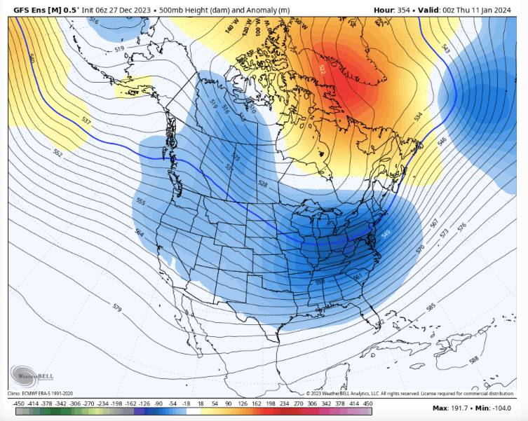
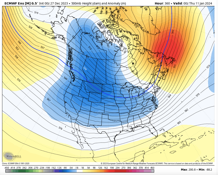
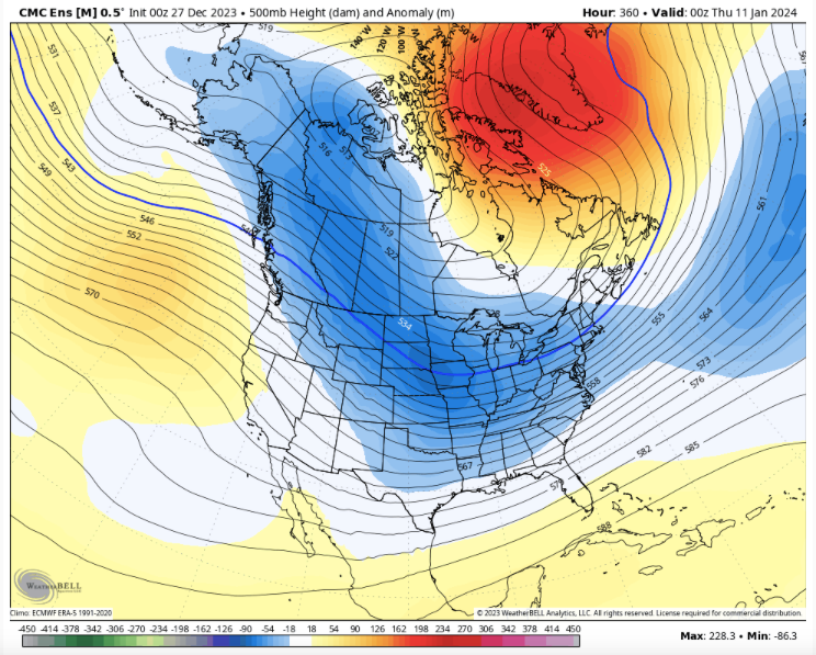
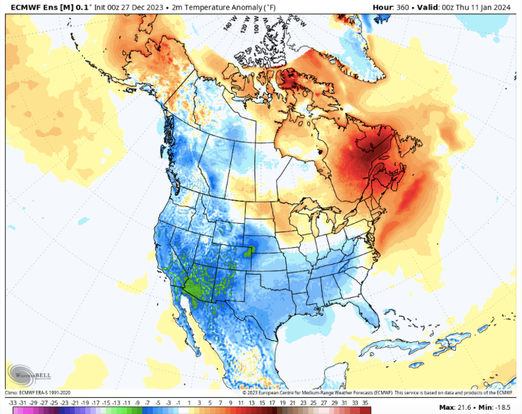
And this is what it looks like at the surface(I might be off 6-12 hours per map due to not paying attention to toggling and being too lazy to go back and fix it!)
I have mentioned the MJO is driving the bus. But when I started digging this morning...maybe it is not??? And that is open for much debate. We may be seeing a winter where the Atlantic is driving the bus. That can happen. We certainly want the Pacific if we can get it, but blocking over Greenland provides confluence over our area(where we want phasing to occur). Right now, phasing is east of us. Let's see what happens if we see HL blocking develop over the Atlantic. Temps may be marginal, but January is our one month where temps don't have to be below normal for snow. We can actually get snow with normal temps to slightly above normal. Now, if these maps flip warmer, we know modeling is probably focusing on the IO/Indonesia area where warm MJO phases originate... For now, we had better hope the AO/NAO take hold.
Of particular caution, the SSW has been occurring for some time. Credit goes to the sometimes maligned JB. He has been writing about this since mid December. I noticed that Amy Butler(nobody better at strat warm stuff) is now mentioning a true SSW might be at hand. Think about this....we are probably in the middle of an extended warming. That means that the actual tropospheric results might be impacting current wx and not just 2-3 weeks out. The caution I mention is this...we often see models erroneously send cold eastward w/ SSWs, and then trend West w/ the cold. That said, that was during the past three consecutive La Nina winters.....the trough wants to go into the West anyway, especially w the past PDO signal. This is more of a signal for cold dropping into the West and sliding eastward with less SER to stop it. Remember when the cold hit the Plateau and wouldn't come a mile further? All of us east of that do, and it was properly discussed yesterday.
With the setup above, the cold would charge down the Plains and crash maybe all of the way to Florida.
Great work and analysis as usual Man!
Some great Winter's featured that Pattern. Jan-Mar 1979 comes to mind. Even the great cold snowy Winter of 77-78 to some extent. Hints of 95-96 in there too. Hopefully that comes to fruition. If so, fun and games.
-
1
-
 1
1
-
-
8 minutes ago, Jed33 said:
I feel your pain! It’s really been the same here I also have only had .30 total precip the last 2 days and most of that was this morning. Just can’t seem to get precip to make inroads into NE TN and SW VA with this system, and the last one was a total bust here. I’ve only had about 2.5in of precip for the month so far and that’s not enough to make a significant difference in the drought that we have had.
Exactly. Same deal with last System. This is 3 Months in a row of well below average Rainfall.
-
2
-
-
2 hours ago, PowellVolz said:
Been a fire hose up the valley the last 3 hours.

.Really shafted here. Drought back to life. Just 0.30" System Total as of now.
-
3
-
-
45 minutes ago, Carvers Gap said:
I suspect modeling is waaaay under doing the warm-up. Ensembles are starting to see the MJO rotation now, but no slam dunk that it is warm. Where I would have said there is about a 90% chance of significant warm wx after the 10th, now I would say 70%. Then cold looms again after that - maybe 4 weeks of seasonal/BN and we make a break for spring. The NAO could completely erase the warm sig on modeling...but I just think the MJO wins.
The way things have gone for several years now, the MJO has tended to win. So, yeah it has the hot hand.
-
1
-
-
14 minutes ago, Matthew70 said:
Is this after the warmup thaw mid month? Or is the warmup being muted?
Should be mitigated and muted due to blocking if MJO is in warm phases at a decent Amp.. If goes circle of death aft ph 3 may not be much of a warmup at all.
-
1
-
-
A boom for you guys east side if Apps, bust western side as downsloping killed us. 0.30 Total here !
-
2
-
-
1 minute ago, Carvers Gap said:
I think what we are about to see is the opening salvo of winter, followed by an undetermined but warm pause, and then multiple repeats of Jan1-10 from roughly Jan22-end of Feb.
Makes sense.
-
43 minutes ago, John1122 said:
The GFS keeps having some version of this around New Years give or take 24 hours. The 18z was a good run for the east middle and eastern areas mostly. Odd snowhle in NE Tn.
Well if it's anything like it was with last weeks event, expect double the amounts shown. Snowhole basically going up through higher eles of Russell County too. I don't see how it came with that " conclusion". Lighter precip northern shield maybe . Downsloping ne valley , none central.?.. Probably just being GooFuS like last week.
-
1
-
-
8 minutes ago, JoshM said:
GFS still has New Years System, but this run just looks weird to me.


Verbatim that should be all snow n and nw quadrant . Gfs did that with last ull , had rain over some areas that was all snow. Thicknesses clearly present snow. Boundary shouldn't be an issue then n and nw quadrant.
-
2
-
 2
2
-
-
Merry Christmas everyone !


-
6
-
-
7 minutes ago, CAPE said:
Yes, WW might have less anxiety with this look.
It's pretty clear where the pattern is headed for mid to late Jan. I have always thought any NA blocking for early Jan would be a bonus, and it appears we are headed in that direction. A relatively brief period of -PNA is not a death knell in a Nino, esp if the NA is favorable. Historically a neutral/-PNA has been a feature in some of our snowiest periods during a Nino. Maybe that doesn't work as well anymore, but that's another subject.
Yeah, that blocking during a Nino is a big time difference maker, even with a -PNA. Historical analysis is clearcut irt that. Even can mute the decent amp MJO warm phases to where we still score in the upper SE and MA.
-
3 hours ago, Carvers Gap said:
Party comes to an end around the 10th, before a likely long pause in winter....hope we can score prior to that. MJO begins to really work around us. Though oddly, the surface maps are still cold as NA really starts to cool off during the first half of January.
Larry had a bit of Info on the MJO Phases and the years noted that stayed cold during warm phases in SE Sub forum. Some good ones in there. January 1978 was one. It was cold and snowy the entire month here. Also , January 2010. He also showed the ones in which it was warm as well. Hard to believe but, they were nearly even. A slight hedge on warm side 51% I think. Blocking and El nino appears to be the difference maker.
-
5
-
2023-2024 Fall/Winter Mountain Thread
in Southeastern States
Posted
Snow began here in Lee County VA around 10:30. Temps running just above freezing so not sticking as it's not heavy enough to overcome the slightly above freezing T and warm ground. A dusting is at mountain around 2000 ft and up so far.