

Daniel Boone
-
Posts
3,542 -
Joined
-
Last visited
Content Type
Profiles
Blogs
Forums
American Weather
Media Demo
Store
Gallery
Posts posted by Daniel Boone
-
-
Wound up with 3.93" here. North Jonesville officially 4.06" . Pennington gap, 4.57". Radar estimates of 5-7 inches northern Lee into Western Wise County. Powell River flooded Big Stone on down to Jonesville. Creeks and Streams flooded.
-
 1
1
-
-
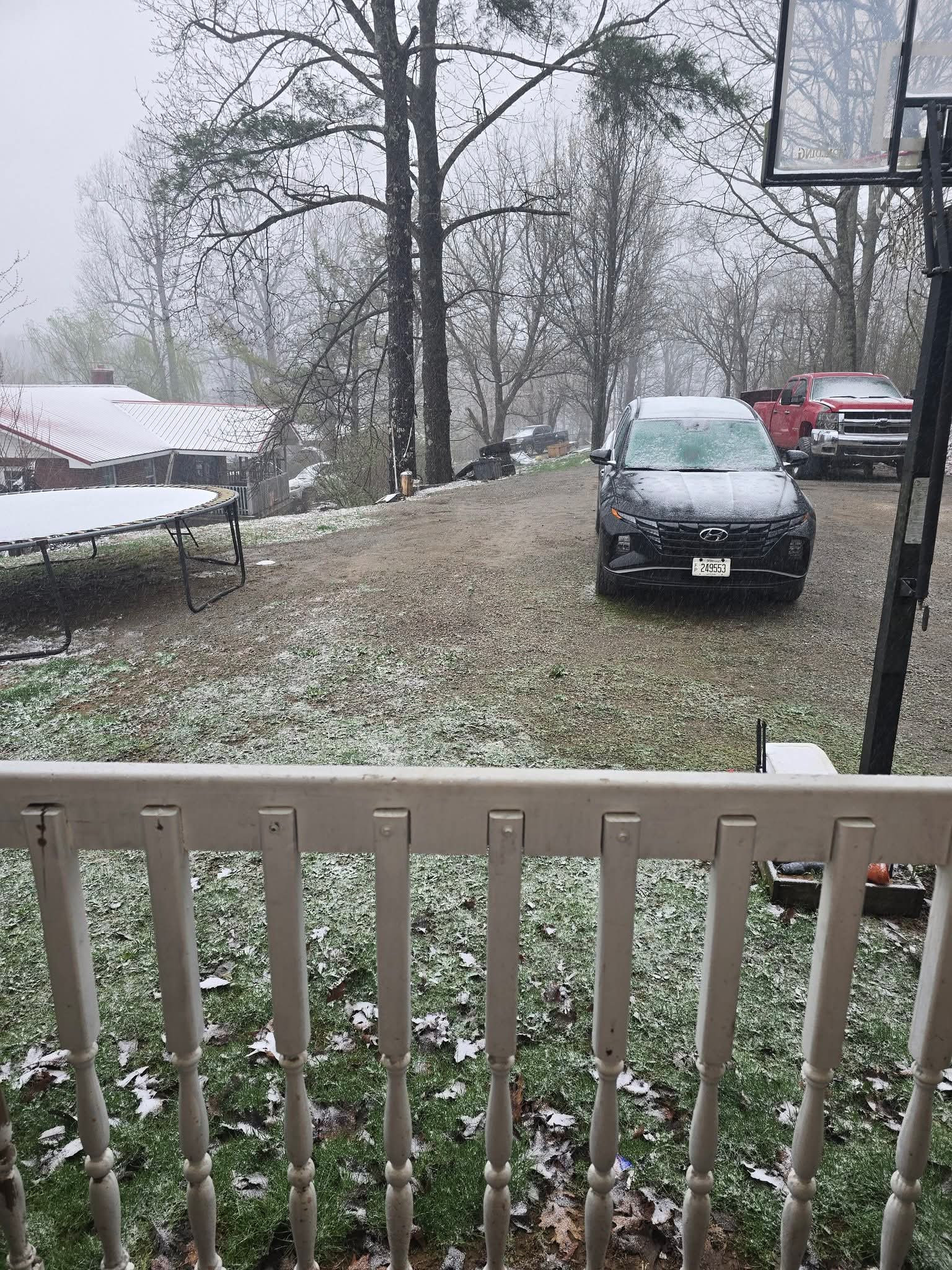
Over 3 inches has fallen here since 3 PM.
-
Really shafted in Lee and Wise Counties over the last 10 Days. 2.75" Total here. 3.69" Monthly Total. Over three quarters of an inch below average.
-
 1
1
-
-
5 hours ago, Carvers Gap said:
My partly cloudy has turned into unexpected rainfall. Not a lot but will take it.
@Met1985, definitely looks like another strong front. This will delay my garden by about a week. I sure didn't see that coming after weeks of temps in the low to upper 80s. What a flip!
Wound up with 0.09" here this Morning. Some thunder and Lightning as well.
-
3
-
-
43 minutes ago, wncsnow said:
Also- this aint gonna cut it
.thumb.png.238ee49ecfc60fec51a5757ff6288366.png)
Exactly. Everything needs to be 200-400 Miles further East. That would be a Drought denter.
-
1
-
-
17 hours ago, EarlGrey said:
I keep seeing references to summer 1977 being similar to this. Is that true? What happened that year?
Hot/dry
-
On 4/3/2026 at 10:08 PM, John1122 said:
One for the ages, 13 inches of cement on the ground here. I'll never forget watching it rip down big, wet, silver dollar + sized flakes. Started around 3pm here and fell overnight. Probably close to 20 inches fell, but there was lots of compacting for 13 inches on the ground.
That Map is low on Totals in much of the area. The Snow started where I lived west of Pennington gap around 1:15 Thursday the 2nd as a rain/snow mix that quickly turned to all Snow. It continued non stop until 1:15 Sunday the 5th. I measured about 20" at it's deepest but, it was melting underneath the whole time as the ground was warm from 2 Weeks of temps in the 70's before this. There was 30" on a parked Vehicle that sat near the north side of my Neighbor's house at the time the Snow ended. I did have some Photos I'd taken of it but misplaced them in moving process.
-
1
-
-
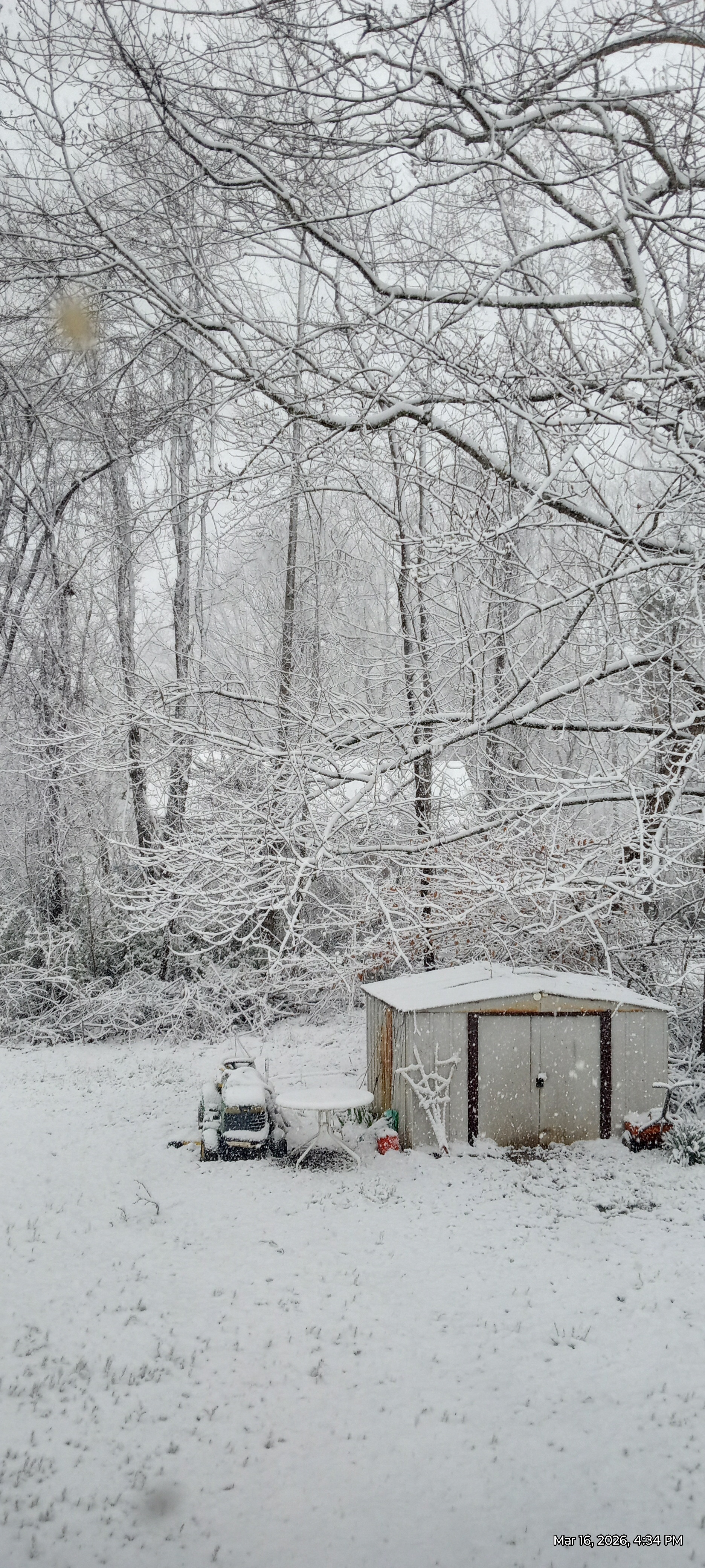
Totalled 3.7 inches at my house. There was 4 inches in fields and on an old mower I have out back. Had it all accumulated there'd probably been 5-6 inches. There's been a lot of Sun here this Afternoon that has quickly melted most if it. A large area of off and on Snow showers are moving west to east just to the North. Some look heavy. If that area had moved further South we may have racked up another inch or two on the Total.
-
3
-
-
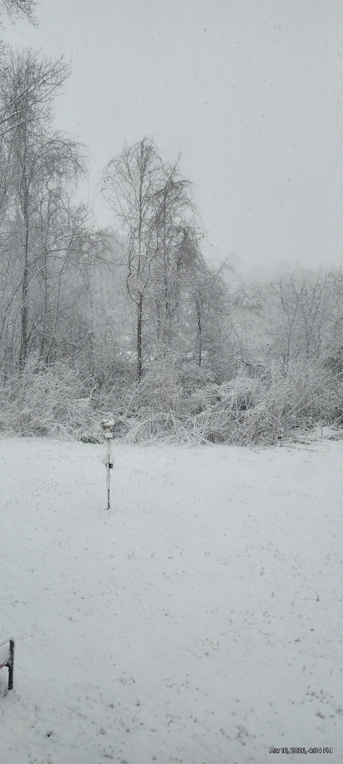
Currently 28 degrees, 87% Humidity. Dp. 24.4. Flurries . Had a couple moderate , gusty Snshwrs after the Synoptic ended that mounted to just a dusting more. Most NWFS has missed my home so far. I watch some heavy area's move across Stone Mountain just to my North and cross near Pennington gap and move to my NE.
-
2
-
-
-
-
Measured 2.5" on Board at 4:30 . Snow has stopped now other than light small flakes.
-
2
-
-
Had between a quarter and half inch on grass and snow board befor snow lightened up for a while. So, melted some..picking backmip now. Had what we already got fell at night we'd probably had over an inch on Snow board. Alot of heat still coming up from ground and Solar heating through clouds this time of year is hampering Accs.
-
1
-
-
Moderate to hevy Snow here with a dusting.
-
2
-
-
On 3/14/2026 at 2:01 PM, Carvers Gap said:
Oh man - I just saw this. I hate to hear that. We will be praying for you and your family.
Thanks Buddy !!
-
 1
1
-
-
1 hour ago, Maggie Valley Steve said:
Praying for you folks.
Thanks!!
-
11 hours ago, GBOVolz said:
So sorry. Prayers to your family
.Thanks Man!!
-
20 hours ago, KakashiHatake2000 said:
My condolences Daniel Boone
.Thanks Man !!
-
7 hours ago, Matthew70 said:
I’m really sorry to hear this. I will keep you & your family in my thoughts & prayers. May you all find strength & peace eventually in the coming days, weeks & years.
Thanks Man !!
-
5 hours ago, jaxjagman said:
Sorry to hear this,my prayers are with you bro
Thanks Man!!
-
2 minutes ago, John1122 said:
I hate to hear that. Condolences.
Thanks Buddy!!
-
1
-
-
57 minutes ago, John1122 said:
This was around 9am this morning at 2600 feet at my cousin's house. It snowed pretty hard here but didn't stick. It was 33 here, probably 30 or 31 up there.
It was same up here. 2000 Feet had a dusting with maybe an inch above 2500 ft on Wallen Ridge near Pennington gap. Norton had Vehicles and grass covered from what I was told. Not alot of observing lately as Son n Law passed little over a week ago and Life here has changed.
-
2
-
-
21 hours ago, Matthew70 said:
52 & 49 next Monday & Tuesday going to hurt. Thankful it appears to be a quick shot that does not last long. Guess it’s time for the folk lore winters. Is it locust up first?
There's a pretty good chance you see colder reading's than that as some very cold air lurks to our North in Canada.
I think around here anyway , the first is called something like Sarvis.?. After a type of Tree I think. Second, redbud, third Dogwood then Blackberry.
Nothing to tat really of course. I've witnessed years with more than that many cold snaps and some less. The Dogwood one "may" have some merit; if you tie in a Spiritual Component.
-
2
-
-
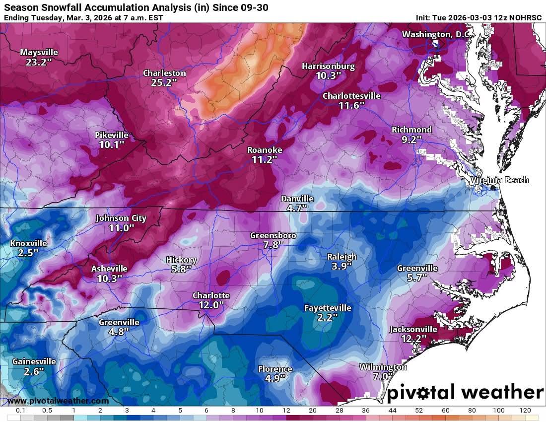
7 hours ago, olafminesaw said:
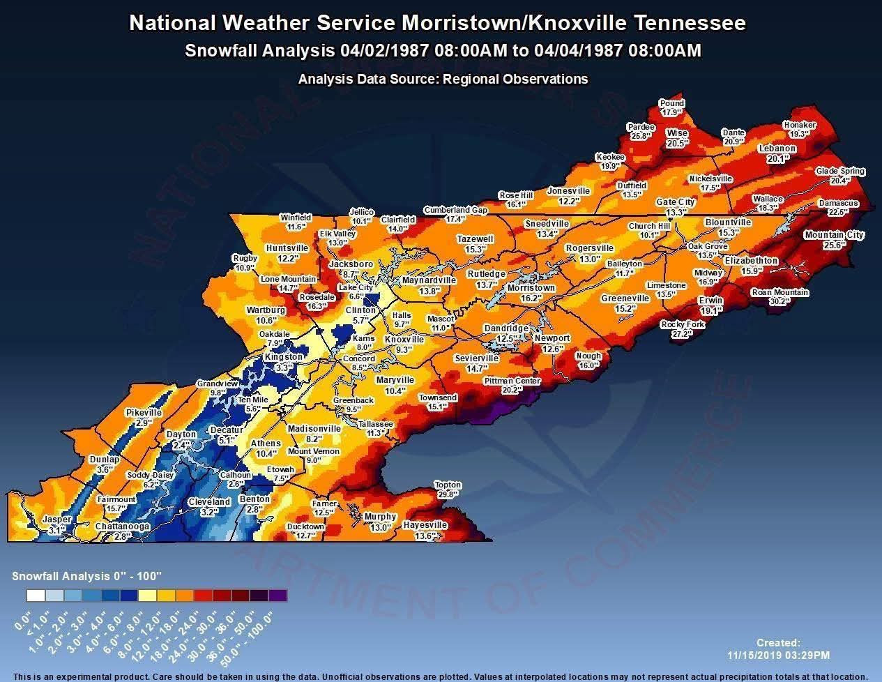
Snowfall totals now that snow chances have dropped to near zero until next winter

Showing half the amount of what I recorded here in Lee County VA.
.png.6a492a0bc46566233c1754aff93bef18.png)
Spring/Summer 2026 Pattern Discussion Thread
in Tennessee Valley
Posted
Even though it caused some issues, it was a godsend overall.