
Itstrainingtime
-
Posts
16,367 -
Joined
-
Last visited
Content Type
Profiles
Blogs
Forums
American Weather
Media Demo
Store
Gallery
Posts posted by Itstrainingtime
-
-
4 minutes ago, Anduril said:
If ya need a description just ask @Atomixwx's mom
")
I literally lost it reading that.
")
-
 1
1
-
-
13 minutes ago, Anduril said:
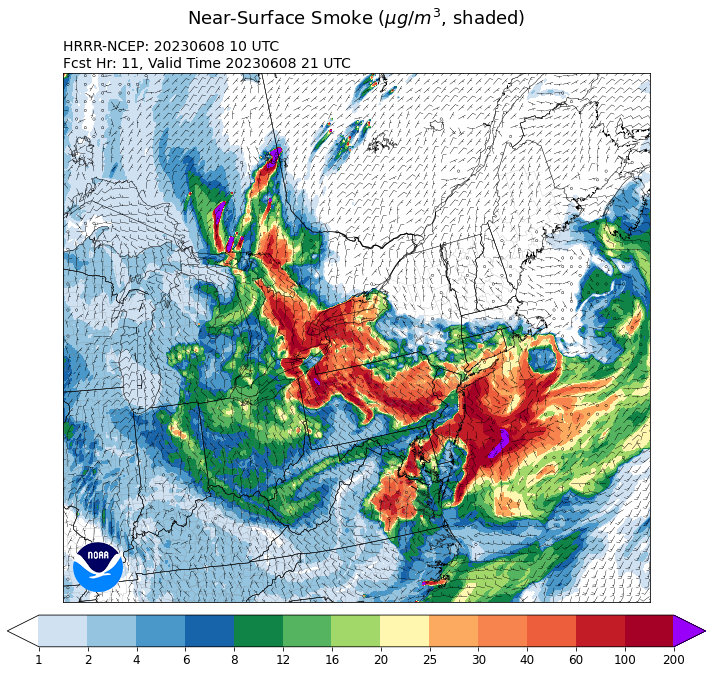
Air wasnt too bad during our 6am walk. Even had some sprinkles during it. Looks like the HRRR wants to bring some nasty smoke again back through in the late morning/early afternoon. Yay
I thought the same thing, and I drove to work through some scattered sprinkles as well.
-
 1
1
-
-
5 minutes ago, Bubbler86 said:
HRRR favors the Western LSV this AM and early afternoon then Eastern LSV later. ITT must be itching to get mow 15 in after some rain earlier this week. Ironic if rain shuts it down. LOL
The itch is real...
-
1
-
-
4 minutes ago, Bubbler86 said:
Big Money was 48 and Voyager 46. You guys must have lost radiational at some point. All these 40's are elevated sensors as well.
I was expecting my temp to be closer to what yours actually was to be honest - also, I made a mistake on MU's low, they briefly dropped to 56 at 4:50am.
-
51 minutes ago, Bubbler86 said:
46 sweet degrees on June 9th,
45 minutes ago, mahantango#1 said:44 here. Beginning to think were in late September.
Wow! The forecast low here was 48, actual low was 57. It was also 57 for the low at MU. Quite a disparity this morning.
-
1
-
-
13 minutes ago, Bubbler86 said:
HRRR is pretty smoky tonight and tomorrow especially West LSV.

Later this evening's depiction - as you mentioned, this might be the worst yet for out your way.
-
Just now, Bubbler86 said:
We need that tropical system to be a reality. The GFS long term is wetter again but feels like winter storms as to watching them dissolve as it gets closer.
Yes, we do. Elliott's 7 day forecast is uninspiring for rain - scattered storms on Monday otherwise mostly dry outside of a pop up shower tomorrow.
-
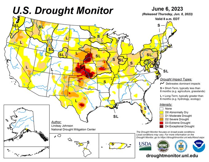
From MU:Here is a full look at this week’s updated Drought Monitor. As the drought worsens, both short-term (agricultural) and long-term (hydrological and ecological) impacts are being and will be felt across PA and MD. We’ll get some rain on Monday, but it won’t be nearly enough..
-
1
-
-
1 minute ago, Mount Joy Snowman said:
If the 12z HRRR is to be believed, it clears out a bit over the next few hours and through the midday but then starts to build back in late this afternoon through the evening. Then it gradually thins out through Friday and mostly clears up as we head towards the weekend, with some lingering but less dense plumes hanging around in western PA and Ohio. Developing....
-
MU mentioned in his disco last night that the smoke is/will contribute to a lessening of rain chances than what the models see - essentially, the vastly dimmed sunshine due to smoke will also limit instability, and thus a lesser opportunity for showers to fire over the next couple of days, and what does fire will be more scattered and weaker than if the air was clear.
-
1 minute ago, canderson said:
MDT rocking a 422 count right now.
It is noticeably worse this morning than at any point yesterday here.
-
12 minutes ago, Bubbler86 said:
I just checked the HRRR and it slowed everything down....comes in later and stays longer into tomorrow. At 12Z (both the HRRR run and time of day tomorrow) you were starting to get into some yellows while now on the 1Z run you are still pink at 12Z. Previously you were to be going green around 15Z now still pink and dark red. If this were a snowstorm we would have been on that within moments of release, but our smoke tracking must not be up to the same level :-). Little to no ground smoke here right now.
El Nino smokestorm - blocking is turning this into a coastal crawler.
-
1
-
-
Still NOT as bad here as last night. No smell and higher visibility.
-
1
-
-
Skies here are clearer now than they have been since Sunday. Blue above with a tint on the horizon.
-
2 minutes ago, Porsche said:
WOW
Dear god...that is crazy.
-
2 minutes ago, Atomixwx said:
Nearly choked on the walk from the car to Walmart.

Sent from my motorola edge 5G UW (2021) using Tapatalk
They have Walmarts in Clearfield County?
-
1 hour ago, sauss06 said:
just reading something on FB about Ocean City Md. they're getting a double whammy, smoke from Canada as well as NJ. must be pretty bad there.
The Pine Barrens in NJ go up in flames in a hot minute.
-
2 minutes ago, Bubbler86 said:
Forum divider to start. First ob's coming in from Lanco instead of Mag or Bub.

Already decided that our after work exercise will be the gym in lieu of a walk.
Expecting to need the lights to drive home this evening at 7pm-ish.
-
15 minutes ago, Mount Joy Snowman said:
Northeastern PA in the thick of it right now. #ItsComing

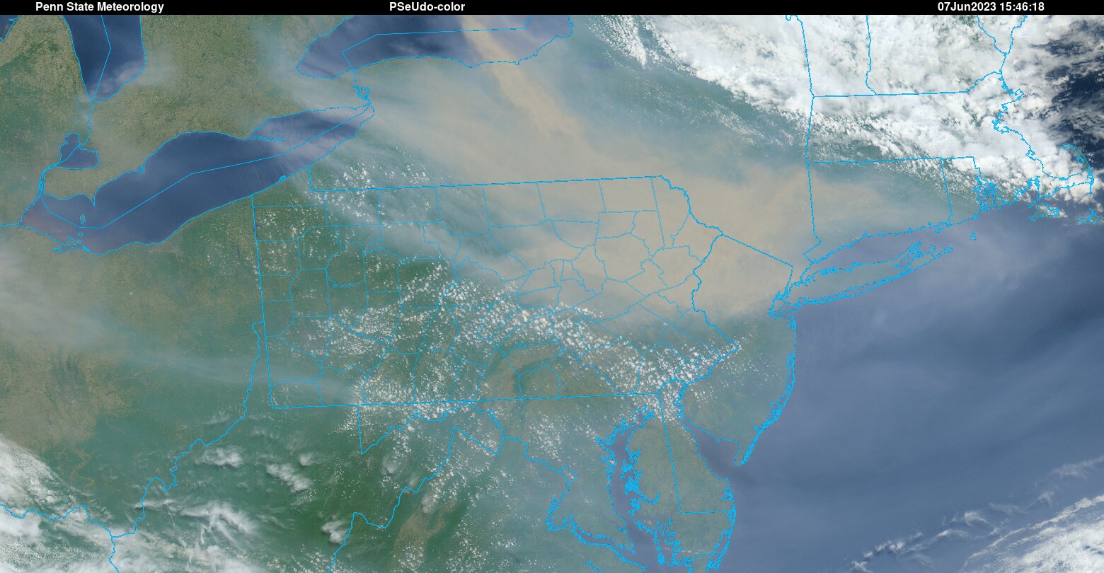
NWS Binghamton tweeted at 9:45am that their temp was "stuck on 50" and despite a lack of clouds, the sun was completely covered by the thickness of the smoke. MU's twitter feed has the exact tweet plus a picture of the sky up there. Seriously, it's crazy to see.
Edit: They also mentioned that there parking lot lights had come back on...it was that dark.
-
1
-
-
3 minutes ago, Bubbler86 said:
On a Spring thread when we are in Met summer. LOL. You watch, on Sept on people will be clamoring to start a fall thread.
Ain't that the truth!
I said yesterday how the sky looks like it does during Albert Clippers of the past, but what is a better analogy is August skies from the 1970s when the heat and humidity were sky high. The amount of haze back then is very reminiscent of what the skies have looked like the past couple of days.
-
I commented last night about how we filled nearly an entire page with evening smoke obs - only to log in just now and discover 2 full pages of new posts overnight/this morning!
This is quickly moving into HECS territory.
On a serious note...be careful everyone. I was working late at the office last night and was moving between building a lot. The smoke late last evening was something else and I could definitely smell and feel it. Waves of it blowing through when the breeze picked up. I'm working today at the Visitor's Center in Columbia which sits right by the river and I can barely make out the hills in York County currently. That's about 1 mile visibility.
-
2
-
-
17 minutes ago, Storm Clouds said:
This smoke forecasting has been more exciting than this past winter ever was!

You're not wrong...
-
Another first in the Central PA thread - almost an entire page of posts in just a few hours in June discussing smoke obs.
-
4
-
-
3 minutes ago, Jonesy56 said:
Just took the dog out for nightly walk, pretty wild.. eyes are burning a bit. Definitely feel for anyone with asthma this week.
.There are waves of smoke blowing past my outside light.
Central PA Spring 2023
in Upstate New York/Pennsylvania
Posted
WPC's 7 day QPF - granted, I have not been posting this daily for comparison, but the forecast maps have been trending the wrong way the past few days: