

MattPetrulli
-
Posts
1,677 -
Joined
-
Last visited
Content Type
Profiles
Blogs
Forums
American Weather
Media Demo
Store
Gallery
Everything posted by MattPetrulli
-
I honestly think that tornado has been on the ground for a while now, just in bad radar area.
-
I wouldn't be shocked if there is a large tornado in progress on that cell, Crocket cell that is. Radar coverage really not helping out currently.
-
...A TORNADO WARNING REMAINS IN EFFECT UNTIL 100 PM CDT FOR SOUTHWESTERN HOUSTON AND NORTHEASTERN MADISON COUNTIES... At 1222 PM CDT, a confirmed tornado was located near Austonio, moving northeast at 35 mph. HAZARD...Damaging tornado and quarter size hail. SOURCE...Public confirmed tornado. Confirmed tornado for Midway cell.
-
That has an impressive look on BR and velocity, could drop a fat one soon.
-
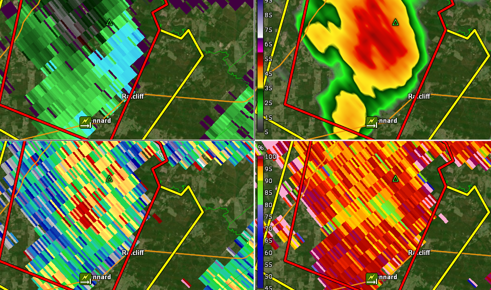
Significant damage with injuries reported in Ratcliff, TX. I looked back on this cell as it passed through Ratcliff and found what looked to be a debris signature..
-
New cell to the SE now tornado warned. The National Weather Service in League City has issued a * Tornado Warning for... Northern Grimes County in southeastern Texas... Southwestern Houston County in southeastern Texas... Eastern Madison County in southeastern Texas... West central Walker County in southeastern Texas... * Until 1215 PM CDT. * At 1150 AM CDT, a severe thunderstorm capable of producing a tornado was located 8 miles southeast of Madisonville, moving northeast at 35 mph. HAZARD...Tornado and quarter size hail. SOURCE...Radar indicated rotation Not even noon central yet.
-
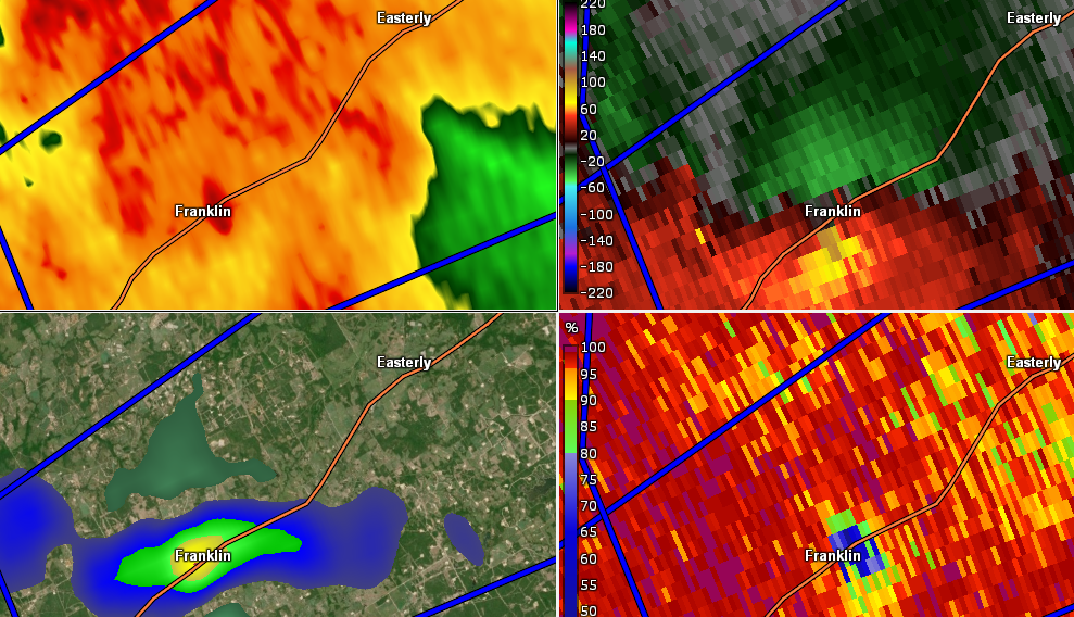
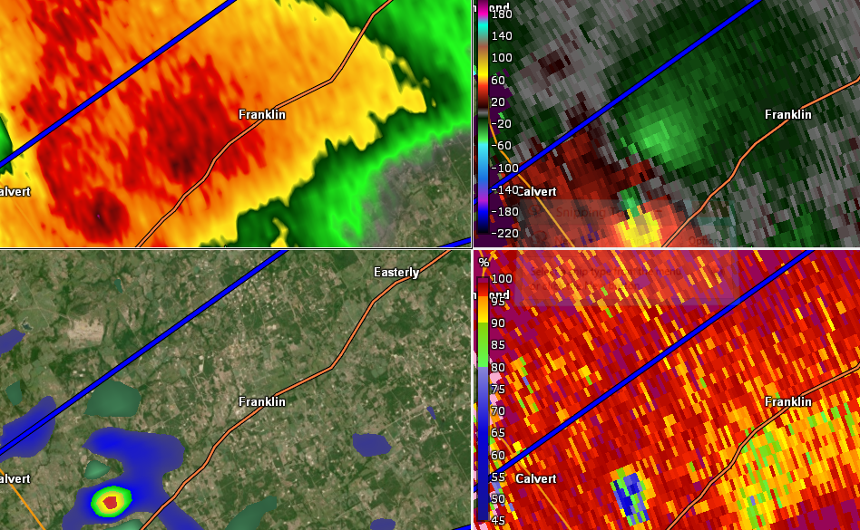
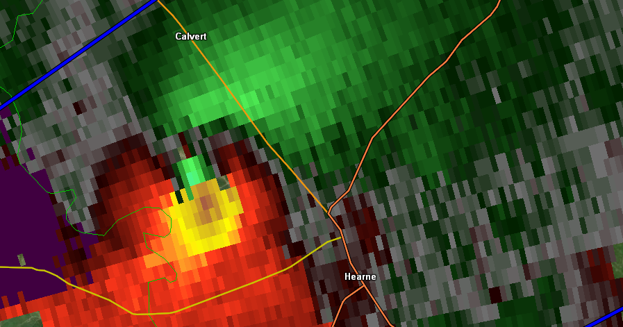
PDS tornado warning issued again The National Weather Service in Fort Worth has issued a * Tornado Warning for... Northeastern Robertson County in central Texas... Western Leon County in central Texas... * Until 1230 PM CDT. * At 1140 AM CDT, a confirmed large and extremely dangerous tornado was located 12 miles northeast of Franklin, or 24 miles northeast of Hearne, moving northeast at 40 mph. Tornado has already produced significant damage. This is a PARTICULARLY DANGEROUS SITUATION. TAKE COVER NOW! HAZARD...Damaging tornado. SOURCE...Weather spotters confirmed tornado.
-
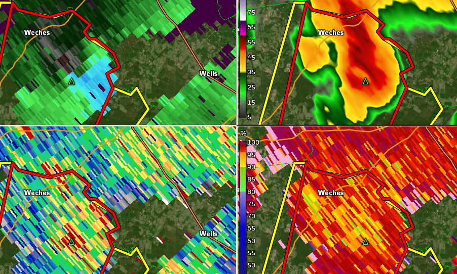
New tornado warning for a cell to the east in Houston County, TX. Has a nice ZDR arc and nice circulation aloft.
-
Tornado warning out now for southern cell.
-
Tornado watch out for East TX and much of central LA until 7 PM, non PDS, 70/60 Don't think probabilities are high enough imo but we'll see.
-
Franklin has taken a direct hit
-
New PDS for this cell * Tornado Warning for... Northeastern and eastern Robertson County in central Texas... * Until noon CDT. * At 1116 AM CDT, a confirmed large and extremely dangerous tornado was located near Franklin, or 9 miles north of Hearne, moving northeast at 30 mph.
-
Mdt stays at 1630z...
-
Franklin, TX is in big trouble. Edit: mind my snipping tool window
-
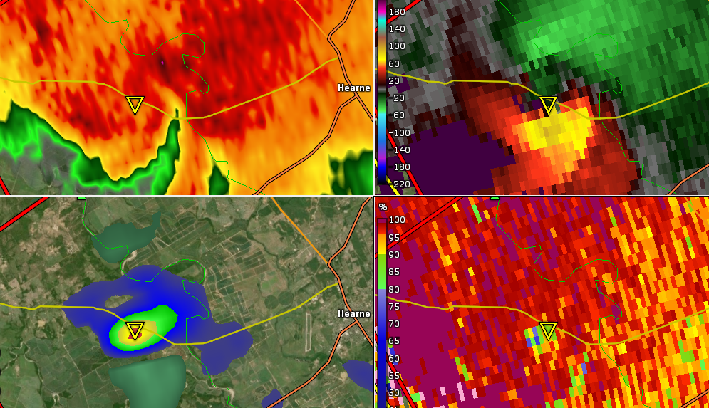
Easily one of the more intense signatures so far this year
-
Very likely tornado in progress
-
Gonna need a tornado warning urgently on the Hearne, TX cell.
-
13z stays moderate risk but with really strong wording ...SUMMARY... Tornadoes -- some potentially strong to violent (EF2+) -- are possible today from east Texas to central Mississippi. Otherwise, numerous severe thunderstorms will pose a risk of large hail, damaging wind and tornadoes from central Texas this morning to the Tennessee Valley region overnight. ...Synopsis... In mid/upper levels, a leading/northern-stream perturbation will eject northeastward across from its present position over Lake Superior and northern Ontario, across Quebec. To the southwest, a deep, high-amplitude trough is evident in moisture channel imagery over NM, far west TX, and northern MX. This trough will pivot east-northeastward today, developing a closed 500-mb low by 00Z near the DFW Metroplex, and extending southwestward across Coahuila. By 12Z, that low should reach eastern MO, with trough southwestward over the Arklatex to deep south TX. At the surface, the 11Z analysis showed the primary surface low along a band of convection south of SJT. A double structure was apparent to baroclinic zones to its east: the first a quasistationary front across central TX to near a SHV-CBM-CHA axis. The southern front was quasistationary just south of UVA and SAT, becoming a warm front over southeast TX and south-central LA, then quasistationary again over coastal AL and coastal western FL Panhandle. The primary surface low should deepen and cross the Arklatex region late this afternoon into early evening, reaching the lower Ohio Valley around EVV by 12Z. The southern is expected to accelerate northward from mid/late morning, to and perhaps past the I-20 corridor in northeast TX and LA, then over Mississippi, likely merging with the northern one. By that time, a cold front should extend from the low south-southwestward across the MS Coast area, likely preceded by an organized quasi-linear MCS over the Deep South. ...TX to Lower Mississippi Valley, Mid-South and TN Valley... A regional outbreak of severe thunderstorms, with the main concern being damaging tornadoes, still appears possible today in and near the categorical moderate-risk area. Only peripheral adjustments were needed for this outlook package, based on convective trends this morning and (on the eastern edge) continuity of overnight severe potential into the early day-2 period. Strong-severe thunderstorms are ongoing across portions of the Hill Country southward toward the Rio Grande. This convection will pose a severe threat into central TX through the rest of the morning. Refer to SPC watches 48-49 and associated mesoscale discussions for near-term details. East of the ongoing activity, the parameter space will become very supportive of supercell/tornado potential through the day in the warm sector, with the main uncertainties being longevity and discreteness of favorable storm mode. As the southern front moves farther inland, a deeply moist boundary layer will spread across the region, with surface dew points commonly in the mid/upper 60s F and locally near 70, PW 1.5-1.75 inches, and mean mixing ratios increasing to 15-16 g/kg, with forecast soundings showing favorably low LCL. Gradual diabatic heating in pockets will weaken already meager MLCINH from midmorning onward, enabling storm formation on pre-MCS sources for weak lift such as confluence/convergence lines, and perhaps persistent/relatively deep horizontal convective rolls. Lapse rates will strengthen with westward extent, supporting preconvective MLCAPE ranging from 2000-3000 J/kg over parts of east TX to 1000-2000 J/kg over portions of LA and MS. Such buoyancy will be more than favorable for all forms of severe, amidst strengthening deep shear related to the approach of the mid/upper trough. Furthermore, low-level shear vectors and hodograph sizes will be quite large along and south of the warm front, with forecast soundings yielding 250-600 J/kg effective SRH. Any sustained supercells in this environment will be capable of significant tornadoes. With time this evening and overnight, convection should organize into a roughly north/south-aligned band over the lower Mississippi Valley region, as deep convergence becomes better-focused in the mass response ahead of the synoptic wave. As this occurs, the main threat in a bulk sense may become damaging wind tonight. However, given the strong inflow-layer SRH, tornadoes still will be probable from both embedded supercells and QLCS mesovortices.
-
HRRR uptrends from 18z, has a tornado outbreak across much of LA with a lot of discreteness continuing into MS overnight
-
18z HRRR still showing numerous discrete cells in Lousiana with very impressive parameters. However, cells may be a little too closely spaced for my liking, so that may be more of a concern than I originally though (I.E. 4/2/17). Still am expecting multiple siggys, but this shouldn't be ignored. HRRR's resolution also may be inflating storm size a little bit too.
-
The fact NAM is still uptrending is quite telling and nerve racking for something potentially dangerous in LA Saturday.
-
SREF is popping a 90 on Day 3.......
-
12z NAM coming in a tad slower, still has a fairly significant event. Central LA in the open warm sector 21z
-
00z NAM continues the trend of a significant tornado outbreak across LA, Southern AR), East TX, and West-Central MS. SREF doubles down and pops a 75 contour which is bigly 4 days out.
-

March 13th-14th Severe Weather
MattPetrulli replied to HillsdaleMIWeather's topic in Lakes/Ohio Valley
I'd say the 2 leading tor warned cells in Indiana are close to having tors in progress or already do.


