

MattPetrulli
-
Posts
1,677 -
Joined
-
Last visited
Content Type
Profiles
Blogs
Forums
American Weather
Media Demo
Store
Gallery
Everything posted by MattPetrulli
-
Don't compare earthquake damage to a category 5 hurricane damage. This is a pretty small storm, but it will be enough to bring potentially massive damage to the PR. Interaction with the mountains of won't do it in time to help San Juan significantly. I don't think you can really over hype a powerful category 5 hurricane heading into a small, but heavily populated island with mountains. Not to mention the economic struggles they have been having lately. Please don't post such irresponsible and blasphemous assumptions.
-
Wayyy too early to make any calls on OTS or LF currently.
-
12z Euro coming in much stronger than 00z, 975 MB and looks like a direct hit to PR and DR.
-

Central/Western Medium-Long Range Discussion
MattPetrulli replied to andyhb's topic in Central/Western States
Already have -
Short-Term Severe/Flooding Discussion
MattPetrulli replied to Quincy's topic in Central/Western States
Probably will need a tornado warning on that cell in a few minutes...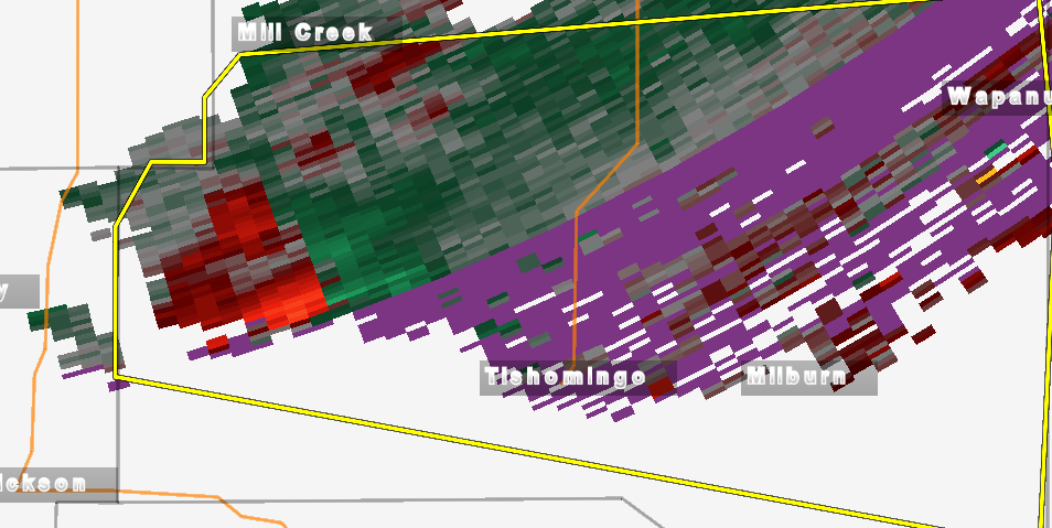
-
Short-Term Severe/Flooding Discussion
MattPetrulli replied to Quincy's topic in Central/Western States
Mill Creek cell developing rotation and a well developed hook. It is also taking a dive to the SE. Here we go... -
Short-Term Severe/Flooding Discussion
MattPetrulli replied to Quincy's topic in Central/Western States
Yeah I'm noticing that via radar. Dbz going down slightly and everything becoming slightly less organized. -
Short-Term Severe/Flooding Discussion
MattPetrulli replied to Quincy's topic in Central/Western States
Cel near Springer, OK already exhibiting some low level rotation. Need to watch this one closely. -
Central/Western Medium-Long Range Discussion
MattPetrulli replied to andyhb's topic in Central/Western States
Looks like a plains severe threat Monday. Still a lot of details to be ironed out. Dynamically looks like a great system. -
Central/Western Medium-Long Range Discussion
MattPetrulli replied to andyhb's topic in Central/Western States
Honestly seems like a classic case for one hell of chaser convergence. Best analog is May 10, 2010. -
Short-Term Severe/Flooding Discussion
MattPetrulli replied to Quincy's topic in Central/Western States
Looking like a nice day for severe storms for North KS and southern NE. On Wednesday night Sent from my Barnes & Noble Nook HD+ using Tapatalk
