WestMichigan
-
Posts
1,372 -
Joined
-
Last visited
Content Type
Profiles
Blogs
Forums
American Weather
Media Demo
Store
Gallery
Everything posted by WestMichigan
-

Winter 2025-26 Medium/Long Range Discussion
WestMichigan replied to michsnowfreak's topic in Lakes/Ohio Valley
18z GFS hits Michigan pretty good around hour 240. Nice to at least see something with decent QPF in the area. LES is great but it would be nice to see a big one at least once this winter. -
Grand Rapids was 20.2F (-4.6F), precip 3.76" (+1.24"), and snowfall 39.4" ("16.8"). Lake Michigan and the frequent LES certainly helped with the monthly precip and snowfall departures.
-
16 straight days of snow at GRR and 24 of the first 29 have had precipitation. Helping ease the drought conditions a little bit this month.
-
Those bands passing through off Lake Michigan are no joke this morning. Less than 1/8 mile visibility when they move through and the wind makes it even worse with the blowing snow.
-
2025-2026 ENSO
WestMichigan replied to 40/70 Benchmark's topic in Weather Forecasting and Discussion
Getting close to 70" here. Hoping I can crack 100" but that will probably be a tall task. Nice to see you have been cashing in on this pattern also. -
Let’s talk winter!! Ohio and surrounding states!! 24'-25'
WestMichigan replied to buckeye's topic in Lakes/Ohio Valley
It is the single day thing. Several storms span midnight so you would have to look at multi-day to get the full picture. -
Not quite as cold as it could have been but impressive nonetheless.
-
I'm a little closer to the lake and clouds held my temperature up to only -8 last night.
-
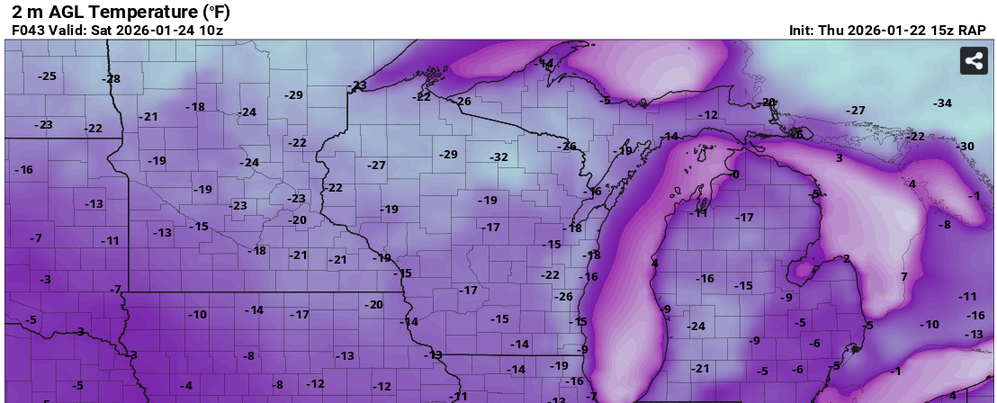
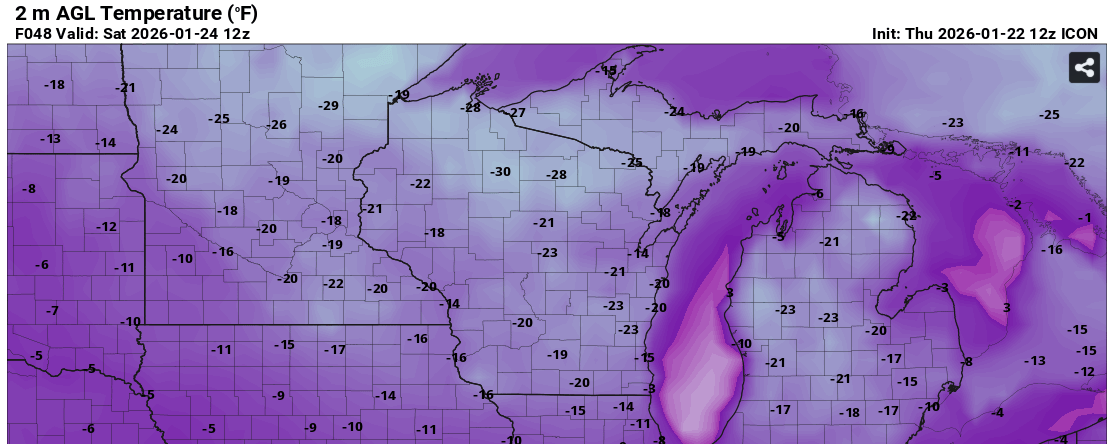
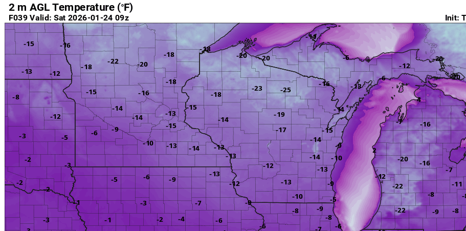
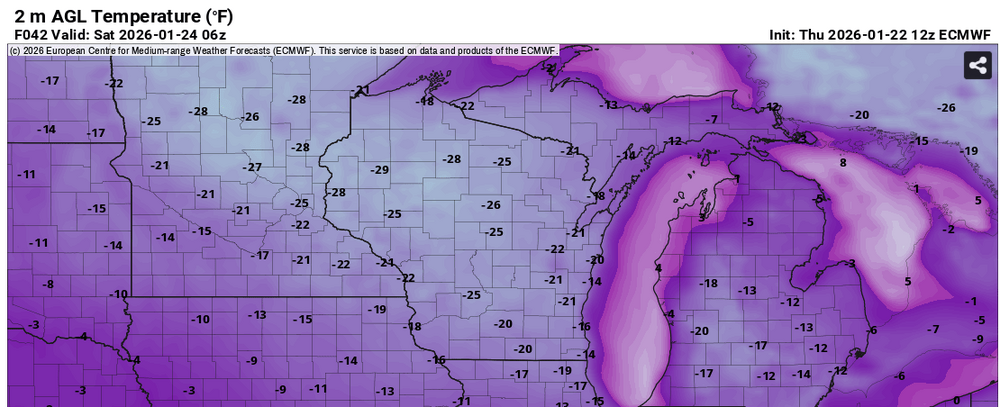
Several models predicting near or tying the all time record low of -24°F at GRR Saturday morning. It will be interesting to see how cold it really gets. HRRR RAP Euro ICON


-
1/24-1/25 Major Winter Storm - S. IL, IN, and OH
WestMichigan replied to A-L-E-K's topic in Lakes/Ohio Valley
As a former Ohioan this is what you hope for and rarely get. Enjoy it! -
Yes, I am not thinking they will break the record but it will certainly get cold. The Euro has backed down a little as of 0Z bue most models seem to be thinking -15°F to -18°F which would for sure set some records. The morning AFD said at least one model gave a 40% chance of -20°F.
-
-
1/24-1/25 Major Winter Storm - S. IL, IN, and OH
WestMichigan replied to A-L-E-K's topic in Lakes/Ohio Valley
Which reason on the list is it to toss the GFS? #6 or I can't remember which one. -
Winter 2025-26 Medium/Long Range Discussion
WestMichigan replied to michsnowfreak's topic in Lakes/Ohio Valley
Euro isn't backing down. All time record at GRR is 2/14/1899 with -24°F. This gets us close to that mark on Saturday morning.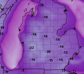
-
1/24-1/25 Major Winter Storm - S. IL, IN, and OH
WestMichigan replied to A-L-E-K's topic in Lakes/Ohio Valley
I know. I grew up in SE Ohio and watched Cheat Mountain, Snowshoe, Spruce Knob, the Maryland panhandle, all of those places get some crazy totals, but this is almost too over the top even for WV. -
1/24-1/25 Major Winter Storm - S. IL, IN, and OH
WestMichigan replied to A-L-E-K's topic in Lakes/Ohio Valley
GFS goes nuts on West Virginia. Bullseye of over 50". No way that happens. -
1/24-1/25 Major Winter Storm - S. IL, IN, and OH
WestMichigan replied to A-L-E-K's topic in Lakes/Ohio Valley
The ICON is a modest jog north from the 00Z run. -
Winter 2025-26 Medium/Long Range Discussion
WestMichigan replied to michsnowfreak's topic in Lakes/Ohio Valley
Haven't heard that in a while. -
Whole house humidifier for the win
-
Winter 2025-26 Medium/Long Range Discussion
WestMichigan replied to michsnowfreak's topic in Lakes/Ohio Valley
GRR is buying what the Euro is selling. -
A good aerial view of it here - Roughly 100 vehicles involved in winter storm pileup on Interstate 196 in Michigan | Fox Weather It is going to be a while before they get everyone out of that mess.
-
It isn't great over here
-
Winter 2025-26 Medium/Long Range Discussion
WestMichigan replied to michsnowfreak's topic in Lakes/Ohio Valley
When it gets very cold, lake effect goes from dendrites to tiny ice crystals and doesn't stack up very fast. Makes for very poor visibility but not great accumulations. -
Winter 2025-26 Short Range Discussion
WestMichigan replied to SchaumburgStormer's topic in Lakes/Ohio Valley
It is pretty crazy out there this morning. 100-car pileup reported on I-196 in Hudsonville area | WOODTV.com -
Winter 2025-26 Short Range Discussion
WestMichigan replied to SchaumburgStormer's topic in Lakes/Ohio Valley
You got your snow last week. Time to let someone else in on the aciton