jewell2188
-
Posts
581 -
Joined
-
Last visited
Content Type
Profiles
Blogs
Forums
American Weather
Media Demo
Store
Gallery
Everything posted by jewell2188
-
2022 Mid-Atlantic Severe Wx Thread (General Discussion Etc)
jewell2188 replied to Kmlwx's topic in Mid Atlantic
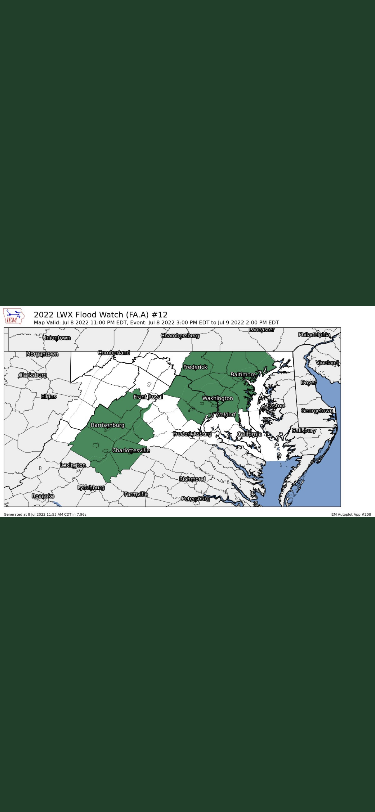
Can someone explain the 3 county gap in between the watch zone lmao???
-
Totals?
-
2022 Mid-Atlantic Severe Wx Thread (General Discussion Etc)
jewell2188 replied to Kmlwx's topic in Mid Atlantic
Why? -
2022 Mid-Atlantic Severe Wx Thread (General Discussion Etc)
jewell2188 replied to Kmlwx's topic in Mid Atlantic
Same type of scenario happened last summer in culpeper county where 7-9 inches fell in just matter of hours. These extreme events keep happening more often. -
2022 Mid-Atlantic Severe Wx Thread (General Discussion Etc)
jewell2188 replied to Kmlwx's topic in Mid Atlantic
I can confirm extensive tree/power line damage in and around warrenton/northern fauquier county. The wind was unreal. Probably the worse I’ve experienced in this area. Ironically I think a lot of us slept on the severe threat compared the the flood threat. But today I’d say we over performed in the severe category. Maybe not area wide but today produced significant damage locally. -
2022 Mid-Atlantic Severe Wx Thread (General Discussion Etc)
jewell2188 replied to Kmlwx's topic in Mid Atlantic
CWG update with some rather strong wording. -
2022 Mid-Atlantic Severe Wx Thread (General Discussion Etc)
jewell2188 replied to Kmlwx's topic in Mid Atlantic
How about the flood risk west of 95? Mike Thomas highlighted earlier the focus of the flood threat would be just west of DC give or take. -
2022 Mid-Atlantic Severe Wx Thread (General Discussion Etc)
jewell2188 replied to Kmlwx's topic in Mid Atlantic
Is the flood threat more of a concern versus the severe ? -
2022 Mid-Atlantic Severe Wx Thread (General Discussion Etc)
jewell2188 replied to Kmlwx's topic in Mid Atlantic
I would expect watches incoming soon. -
2022 Mid-Atlantic Severe Wx Thread (General Discussion Etc)
jewell2188 replied to Kmlwx's topic in Mid Atlantic
Looks like a rather meh day. -
2022 Mid-Atlantic Severe Wx Thread (General Discussion Etc)
jewell2188 replied to Kmlwx's topic in Mid Atlantic
Looking like flooding may be the biggest concern. -
2022 Mid-Atlantic Severe Wx Thread (General Discussion Etc)
jewell2188 replied to Kmlwx's topic in Mid Atlantic
Aside from that lone cell. This mornings activity ruined todays true potential. Which is fairly common around here lol -
2022 Mid-Atlantic Severe Wx Thread (General Discussion Etc)
jewell2188 replied to Kmlwx's topic in Mid Atlantic
Did the enhanced get shoved further west from earlier? -
2022 Mid-Atlantic Severe Wx Thread (General Discussion Etc)
jewell2188 replied to Kmlwx's topic in Mid Atlantic
Seems like we will have very little clearing east of the blue ridge. -
2022 Mid-Atlantic Severe Wx Thread (General Discussion Etc)
jewell2188 replied to Kmlwx's topic in Mid Atlantic
This has the look of East of the bay event. -
2022 Mid-Atlantic Severe Wx Thread (General Discussion Etc)
jewell2188 replied to Kmlwx's topic in Mid Atlantic
You better hope for prolonged sunshine. Without that this time of the year, your pissing in the wind lol. -
Unless we had measurable snow today, after the spring weather we’ve had, today absolutely sucked!!!! Bring on the 80’s and 90’s!!!
-
3/12 Event: Winters Last Hurrah at Least East of Mountains
jewell2188 replied to Weather Will's topic in Mid Atlantic
Back edge rapidly approaching. -
3/12 Event: Winters Last Hurrah at Least East of Mountains
jewell2188 replied to Weather Will's topic in Mid Atlantic
One could laugh at this but one could also understand this could be a sneaky event. It would be fitting given the winter we have had. -
2022 Mid-Atlantic Severe Wx Thread (General Discussion Etc)
jewell2188 replied to Kmlwx's topic in Mid Atlantic
I would think with a mod La Niña this spring, that would mean an active severe season for us? -
The guy literally is a joke. Almost certain he’s not really respected regardless of his knowledge.
-
Now that we are back to reality, looking forward to spring!!!
-
January 28-29, 2022 Miller abcdefu Storm Threat
jewell2188 replied to WxUSAF's topic in Mid Atlantic
And of course DT with the update when Richmond gets snow -
January 28-29, 2022 Miller abcdefu Storm Threat
jewell2188 replied to WxUSAF's topic in Mid Atlantic
So where do we stand??? How do road crews prepare??? -
January 28-29, 2022 Miller abcdefu Storm Threat
jewell2188 replied to WxUSAF's topic in Mid Atlantic
CWG basically just declared this a non event 95 West. It’s over….