

qg_omega
-
Posts
3,044 -
Joined
-
Last visited
Content Type
Profiles
Blogs
Forums
American Weather
Media Demo
Store
Gallery
Posts posted by qg_omega
-
-
38 minutes ago, Typhoon Tip said:
yeah...and so it goes, let's blow the roof off the top of the charts now struggling to quantize how the physics in the models are eating a steady diet of climate change heat fluxes ... lol I doubt this happens but it sure is cool looking. I like how the atmosphere strikes oil over San Diego

January of last year comes to mind
-
 1
1
-
-
26 minutes ago, WestBabylonWeather said:
Well I wasn’t expecting this development
Chances of the Euro verifying at this stage is close to zero
-
2
-
 5
5
-
 2
2
-
-
5 minutes ago, Sey-Mour Snow said:
6z gefs was nice in long weenie range

Nice for warmth?
-
22 hours ago, brooklynwx99 said:
who knows. going AN every year does not provide much value, though
https://x.com/ericfisher/status/1742283208467611750?s=46&t=m4Eqkekadb-JCXTm7k-Txg
-
1
-
-
3 hours ago, Prismshine Productions said:
+PNA, -NAO, just in time for Valentines Day

Sent from my SM-S146VL using Tapatalk
I don’t think you know how to read 500mb maps, maybe @brooklynwx99 can help. He lives at 500mb
-
4
-
-
1 minute ago, the_other_guy said:
you declared winter over on January 20.
Winter is over bud
-
2
-
 1
1
-
2
-
-
10 minutes ago, Allsnow said:
We can’t use typical enso responses anymore in this new climate. Backloaded February Ninos are not a lock anymore. I think we are cooked outside a light event in early March that doesn’t stick in Central Park
Correct, I said this months ago. Typical loaded February Nino is no longer relevant. SSTs are so warm on a global scale, anything before 2015 really can’t be used
-
2
-
-
44 minutes ago, Allsnow said:
It’s a torch of historic proportions, complete 180 to the PV overhead in the Midwest
-
1
-
-
4 hours ago, jbenedet said:
November - wrong.
December - wrong.
January - wrong.
But read my free $hit at blogspot.

Can't forecast for $hit but don't worry he'll be sure to tell you he's wrong. You can count on that. What a service.
But I’m the one 5 posted? SMH
-
3
-
1
-
11
-
 1
1
-
1
-
-
5 minutes ago, SBUWX23 said:
Don't think we are getting that warm. Maybe 50?
I’ll take the over for 100
-
1 minute ago, dendrite said:
Yeah thank god we froze our asses off all week for the sake of the pond ice
Past week cold was run of the mill, not impressive and almost no records. Will see more records on the warm side Friday this week
-
3
-
-
2 hours ago, donsutherland1 said:
A much milder period lies ahead. The development of an EPO+/AO+ pattern will lead to a noticeable warming trend. Temperatures could peak well in the 50s in New York City and Newark and 60s from Philadelphia southward late in the week. This warm period will assure that January will wind up as a warmer than normal month and Winter 2023-24 will become yet another warmer than normal winter in the New York City and Philadelphia areas. The generally mild conditions could continue into the first week of February with only brief interruptions.
A storm could bring moderate to perhaps significant precipitation to the region from Wednesday night into Friday morning. Ahead of the storm, some ice and sleet is likely far north and west of New York City and Newark, mainly from the Hudson Valley north and westward from late Tuesday through Wednesday.
The ENSO Region 1+2 anomaly was +0.9°C and the Region 3.4 anomaly was +1.9°C for the week centered around January 10. For the past six weeks, the ENSO Region 1+2 anomaly has averaged +1.18°C and the ENSO Region 3.4 anomaly has averaged +1.95°C. A basinwide El Niño event is ongoing. The ongoing El Niño event has recently peaked.
The SOI was +10.93 today.
The preliminary Arctic Oscillation (AO) was +1.284 today.
On January 19 the MJO was in Phase 5 at an amplitude of 2.875 (RMM). The January 18-adjusted amplitude was 2.993 (RMM).
Based on sensitivity analysis applied to the latest guidance, there is an implied 96% probability that New York City will have a warmer than normal January (1991-2020 normal). January will likely finish with a mean temperature near 36.4° (2.7° above normal).
I remember last week your sensitivity analysis had Jan at +.6 which seemed much too cold. It’s been slowly and now recently rapidly going up to 2.7 which is likely still too cold
-
1 hour ago, 40/70 Benchmark said:
I may lose it if we find our way to February with nothing imminent after having succeeded in pulling that off....this is about the point at which I came unhinged last year.
Ray, many have had it much worse than you with a near HECS. No one expected normal snowfall this year with the strong El Niño. Next year we go right back to strong Nina. Not sure how we break this with AGW running away and increasing thermal activity
-
1
-
1
-
-
1 hour ago, 40/70 Benchmark said:
I find that evolution awfully disapointing and hope that its wrong.
Looks too cold, go warmer the MJO plus PAC extension favor record warmth. Very little to no cold records with this current airmass (Northeast) but likely record warmth on Friday and then again late next week.
-
1
-
1
-
-
4 minutes ago, nycsnow said:
Boston getting some decent snow, not forecasted at all
Euro had it
-
1
-
-
Winter is over
-
1
-
1
-
1
-
2
-
-
I was on the February this is not a standard El Niño forecast very early, no surprises on the mega torch to start the month. Fits MJO + PAC Jet
-
1
-
-
2 hours ago, dryslot said:
Plenty of snow up here in Eustis, Rode 72 miles to Jackman having lunch at 4 seasons.
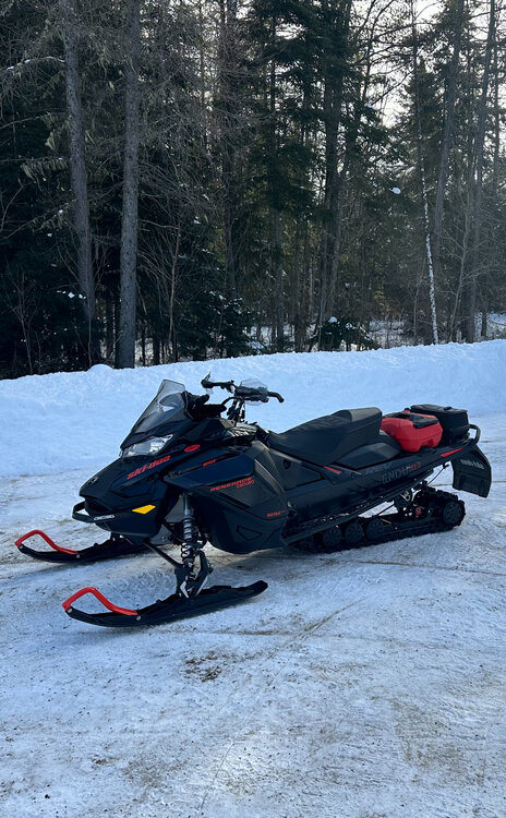
Nice sled
-
1
-
-
13 hours ago, 40/70 Benchmark said:
Good forecasts. @ORH_wxmanDoes the scoreboard have any bearing on a 5PPD being removed?? I would lift that, man.
Thank you Ray, appreciate it
-
1
-
-
4 hours ago, donsutherland1 said:
I doubt it. NYC is at 1.9". I think Central Park will see at least 0.5". Winter 2022-2023 had season-total snowfall of 2.3".
Don’t think they going to record 0.5
-
1
-
-
3 minutes ago, Brian5671 said:
Hopefully we can get a decent period somewhere before mid March...imagine if this ends up being our only week of true winter? LOL
thats my forecast so not crazy to think that
-
1
-
1
-
-
On 1/17/2024 at 10:48 PM, The 4 Seasons said:
First call, will issue an update if needed.


Beer?
-
On 1/17/2024 at 10:08 PM, qg_omega said:
Toss the 12k, 3k being much less is a big red flag. She gone
Shocker
-
5 hours ago, brooklynwx99 said:
i do like seeing these HP continuously getting ejected into S Canada. two 1040-50mb HPs is nothing to sneeze at. can give us a chance at a WAA event even with a crap longwave pattern. the HP make sense given the ridge over AK
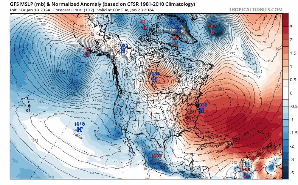
What a massive Bermuda high for late January


Monitoring the 29th/30th for significant impact coastal redevelopment - confidence only medium for now but is trending favorably.
in New England
Posted
GFS taking the lead here, she’s gone