

qg_omega
-
Posts
3,044 -
Joined
-
Last visited
Content Type
Profiles
Blogs
Forums
American Weather
Media Demo
Store
Gallery
Posts posted by qg_omega
-
-
2 minutes ago, Ginx snewx said:
Everyone I talk to said Jan skiing was fantastic.
It was dry with overnight mins 20 above normal and highs in the 30s for a few weeks

-
 1
1
-
-
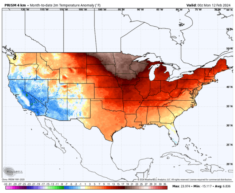
Two storms this winter is about what most expected, a week of winter in Jan with a storm and another ongoing week now with a very similar storm just displaced 100 miles or so south. Upstate NY to NNE have seen nothing for months which is really amazing and that doesn't look to change at all going into March. Just an historically bad winter, last year was MUCH better overall for the Northeast. Most Ski resorts finished normal to above normal, not a chance this winter. The best month for the ski resorts was November...think Jay had 100 before December this year...
-
2
-
 1
1
-
-
17 hours ago, Terpeast said:
Even if this La Nina stays weak-moderate, the surrounding warmth of the oceans and the West Pac will create a very strong La Nina state much like 2022-23.
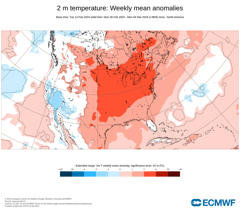
With a +QBO and solar cycle beginning to descend, we will likely have less blocking than even 2022-23. With all the cold air bottled up at the pole/Siberia or again dumping to the western NA, I'm thinking AN to much AN temps across the entire CONUS except maybe near normal over the Pac NW. East coast will likely be much AN+++ with 60s being commonplace, with strings of 70 degree days interspersed throughout even the deepest winter months.
Warmest winter on record across the east? Even higher chance of that happening than this year and last year.
100 percent, this is a great forecast
12 hours ago, ORH_wxman said:Most of New England has a very weak correlation to ENSO when it comes to snowfall. Weak El Niño is the best ENSO state but you see big snows in many other ENSO states as well. George is correct that a very potent El Niño is prob the worst.
It typically comes down to other factors here. You can have a potent La Niña with little blocking and still be good (07-08 is a good example) but also an awful potent La Niña with little blocking (1999-00 comes to mind).
None of that matters anymore given the record warmth in the maritime, MJO will drive ridges east and troughs west with the cold on the other side of the globe going forward.
-
 1
1
-
-
I would say this year very similar to last year here in terms of temps and snow, strong La Niña or strong El Niño, same result
-
Big El Niño backloaded February so far
-
1
-
-
/End Winter. 3 months has become two weeks, sad times
-
2
-
 1
1
-
1
-
-
15 minutes ago, 40/70 Benchmark said:
You asked me to give a reason why the pattern would be different in February and that was my response. I also made it clear why this year is more prone to Maritime forcing than other el Nino seasons. You always cherry pick quotes from people. The composite is what it is, but I also had years in there like 1995, 2007 and 1973 for a reason.
was I wrong to push back on it, my reasoning was posted when we had that exchange in Jan
-
1
-
1
-
-
3 minutes ago, brooklynwx99 said:
i mean, normally, the fail mode in strong Nino Februarys is an overly oppressive GoAK low, not whatever the hell this is. this makes no sense

Been on the fake PNA all year, above fits the pattern very well and the above normal to much above March. This is top 5 warmest winter for the CONUS with many in the upper Midwest to NNE at the warmest DJF ever, why would that suddenly flip. I said same to Ray in January and his response was a 500mb composite of past Nino’s
-
3
-
1
-
-
45 minutes ago, 40/70 Benchmark said:
29" on the season with average of like 62".
Can’t be upset with 30 inches during a top 5 historic warm winter. We take that all day
-
1
-
-
Just now, ORH_wxman said:
It looks like it is going to....coming in flatter on 18z so far. Not sure it will be as bad as the RAP, but the trend will be south this run.
She gone
-
1
-
-
14 minutes ago, Damage In Tolland said:
You don’t go from 12-18” to dim sun and no snow . It’s too close in. We are 12 hours away from snow starting
Epic bust upcoming
-
1
-
2
-
-
Why is the Euro wrong? All I see in here is weenies chucking insults. Looks like UKMet which hasn’t changed in days.
-
 1
1
-
-
1 minute ago, Dark Star said:
Dunno, I don't think any MAJOR roadway in NYC will be terribly affected?
Hard to stick with temps above freezing and layers of salt on roads and warm ground
-
2
-
-
Never believed those strong storms, doesn’t fit the pattern at all. Weak and south makes the most sense given pattern
-
1
-
1
-
4
-
-
Kinda shocked how strong the storm is modeled, if that’s true many will flip to snow but no storm this year has been that strong
-
1
-
-
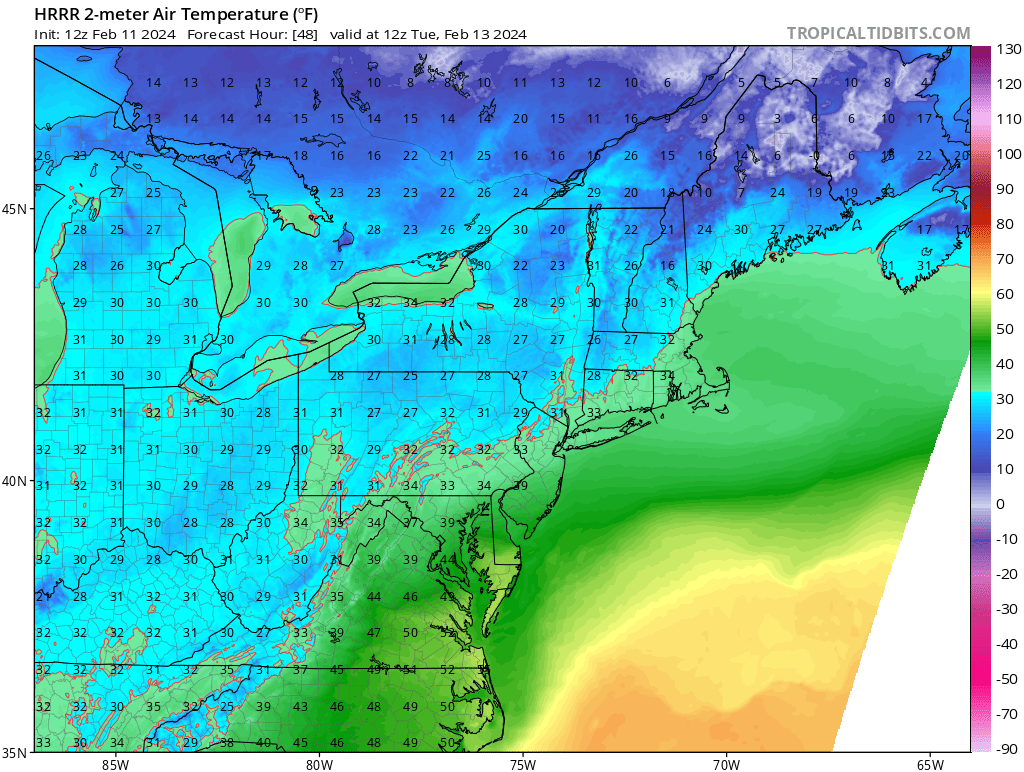
13 minutes ago, donsutherland1 said:
It should be noted that the low temperature during the storm is 34 on the 18z HRRR. NYC has never had a 10”+ snowfall with such temperatures. The NAM briefly dips below freezing, so its solution is more defensible based on its own numbers. Until the other guidance suggests colder readings than 34-36, it’s difficult to buy these more aggressive solutions for NYC, JFK, and LGA.
HPN?
-
-
3 minutes ago, ORH_wxman said:
Hrrr is pound town for CT Tuesday morning.
Pounding grass?

-
2
-
3
-
-
On 2/10/2024 at 8:07 AM, qg_omega said:
Looks like rain to white rain for the coast, maybe an inch or two at the end on the grass. Would be great storm if we had a normal February airmass
Mostly white rain, temps in the mid to upper 30s lol
-
4
-
-
Just now, dryslot said:
The issue is, Your transitioning to a different one, Its not set yet.
not seeing that at all, we go to a week of "winter" after this storm with temps normal to above normal before the PAC blasts the country with warm to end winter. Its a repeat of Jan's one week of winter. Who ever threads the needle with this storm on Tuesday will score while the rest will stay at almost no snow. I suspect for NYC they add maybe an inch to their 2.2 inches of snow so far this year.
-
6 minutes ago, MJO812 said:
Icon

.thumb.png.b5ea239a292c743d5272ff1b709de959.png)
.thumb.png.12a9df5e6549505ad9c3f4cabace9367.png)
fits the Jan pattern, thread the needle with main low in western PA moving east. I buy this and sell everything else
-
8 minutes ago, Allsnow said:
Years of disappointment and north trends have us all pessimistic. I don’t have a good feeling about this one
Just no cold air this year, absurd warmth to Montreal week after week
-
Looks like rain to white rain for the coast, maybe an inch or two at the end on the grass. Would be great storm if we had a normal February airmass
-
2
-
-
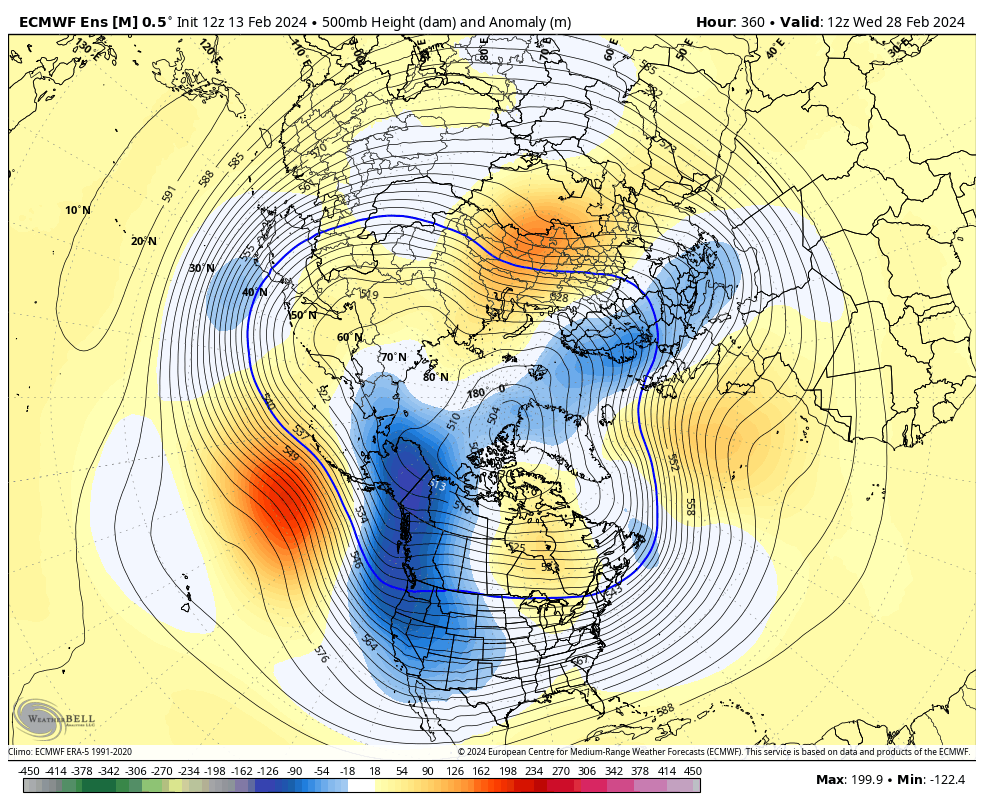
Epic pattern past the 20th is gone but it never was. Need to stop looking at 300 hour plus ensembles. Weeklies need to not be run. I never bought into the PNA, it just never made any sense given the pattern we have been in with the strong PAC extensions, Nino, Maritime forcing etc. SSW and PV splits also have driven the cold each time on the other side of the pole, they need to be examined in the context of the pattern and forcing
-
1
-
1
-
3
-

It was a Flop... February 2024 Disco. Thread
in New England
Posted
Foot of snow in the Clipper death band last night just SW of NYC, looks like west Hartford just displaced SW