

qg_omega
-
Posts
3,048 -
Joined
-
Last visited
Content Type
Profiles
Blogs
Forums
American Weather
Media Demo
Store
Gallery
Posts posted by qg_omega
-
-
Chicago blizzard fail?
-
-
When is the pattern change for colder? Jan 20 to 24? Then winter is over?
-
 2
2
-
-
Just now, jbenedet said:
Looks like for a week, with best snow chances for SNE of the season.
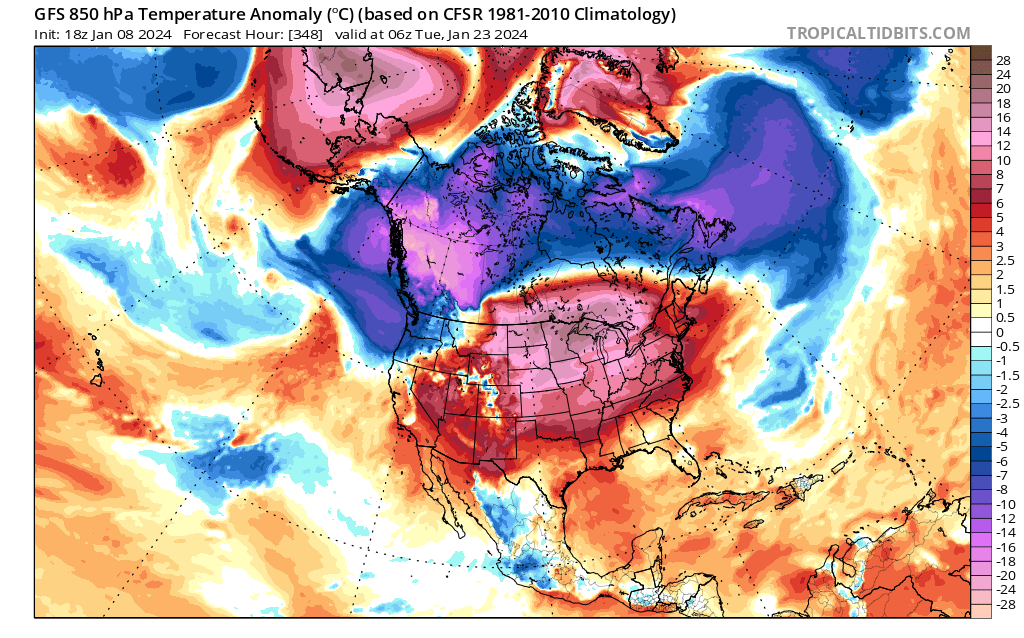
But I see a big warmup beginning around the 20th. Not sure it can classify as a January “thaw” given how warm it’s been outside of far interior of NNE, but that’s the cliche. Might pass for a thaw after next week’s cold.
It’s a transient cold shot that is a much modified version of the cold over the west.
-
December winds were much more impressive here, no two hour delay for the kids like last storm
-
 1
1
-
-
1 minute ago, psv88 said:
ACY gusted to 58. Lots of outages in SW Jersey around Trenton, moving up to Morris County. So the wind is verifying in NJ, where it’s in the upper 50s. 54 here now and rising
Watertown gusting to 78 at 48 degrees
-
3 minutes ago, psv88 said:
You know I’m in Suffolk county right?
Worst winds are ahead of the line not in it, say 30 mins ahead of it. Line is 45 mins from Manhattan, another hour to you. Worst winds are next two hours for you
-
Just now, psv88 said:
We haven’t gusted to 50 yet, but worst isn’t for another 2-3 hours.
Only an hour or so before it’s over, maybe 2 hrs max for you
-
Winds almost calm here, nothing like 12/18 at all. Snow pack keeping the inversion strong
-
2 minutes ago, WestBabylonWeather said:
The wind is howling now. Been awhile since I heard that sound

Yes, just a few weeks ago on the 12/18 storm lol
-
11 minutes ago, the_other_guy said:
I just wanna throw this out there to temper some of the hysteria with the winds.
weather to us is literally life and death in aviation. here are the aviation forecasts for JFK and Islip over the next 24 hours. as you can see, there’s nothing anywhere near 75 mph even if you convert knots to MPH.
Now, Im not saying on the immediate coast there aren’t going be higher gusts and sustained winds.
But for the vast majority of the people in this forum, this will be heavy rain with winds around 30-50 miles an hour. And even that is the high end.
just wanted to throw this government forecast for the two coastal airports in our area out there.


This doesn’t help
-
2
-
-
57 minutes ago, jbenedet said:
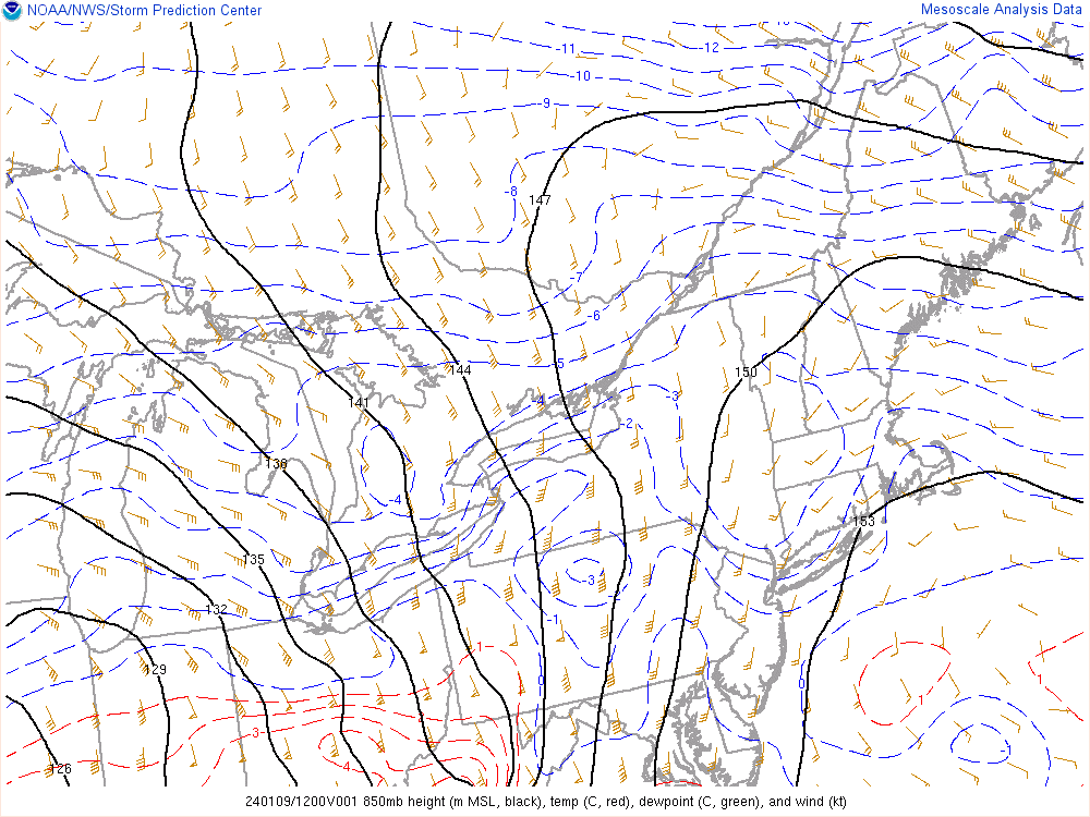
Fake cold. 850s already near 0C in SNE.
torch it.
Don’t lie, this will drop several inches in the mountains
-
1
-
-
20 minutes ago, SnowGoose69 said:
Given how slow models have been with it it'll probably be in 6 by then
Lags
-
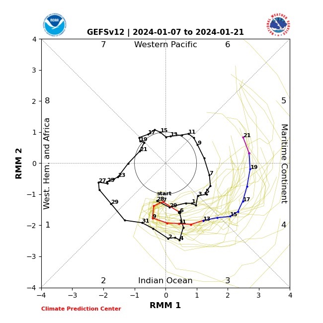
On 1/7/2024 at 5:53 PM, SnoSki14 said:
Take into account the MJO lag of about a week puts Jan 15-23 in a favorable period with an unfavorable period right after until MJO gets into more positive phases.
Welcome to MJO 4 past the 20th
-
1
-
 1
1
-
 1
1
-
 4
4
-
-
58 minutes ago, 40/70 Benchmark said:
At Logan? Most of the city was probably 5-6"...
https://x.com/ericfisher/status/1744173588607910051?s=46&t=m4Eqkekadb-JCXTm7k-Txg
-
How much snore my snow did Pope receive? Guess mid Atlantic snowstorm fail
-
18 minutes ago, 40/70 Benchmark said:
For reference....
FINAL CALL:
Did Boston get 1.9?
-
How much did Boston get?
-
Close them until February, remember when many were said COD after 3? Insanity
-
2
-
-
7 minutes ago, SnowGoose69 said:
I am straight up gonna pass out if TN/GA/SC sees a snow event 1/18-1/20 but I am way more worried about that than I am the Op Euro/CMC ideas....their ensembles sort of show that too...much more likely we see something suppressed
Violently disagree
-
7 minutes ago, Sey-Mour Snow said:
Salivating over the Band in Northern Fairfield and Southern Litchfield 42-48dbz.. Has to be 2-3" per hour.
Reports of 4 to 5 inches an hour in NY
-
 1
1
-
-
2 minutes ago, southbuffalowx said:
Ripping in Poughkeepsie and the heavy band hasn't even reached yet. Eyeballing ~7" on my back deck.
There was maybe an inch at 9PM..
That’s insane
-
Not many if any models had HPN at 30 degrees, looks good for 4 to 6 inches
-
3
-
-
3 minutes ago, Allsnow said:
Do you see a mild risk towards months end with the mjo?
I have my doubts we see a sustainable +pna in February with how bad it’s been lately
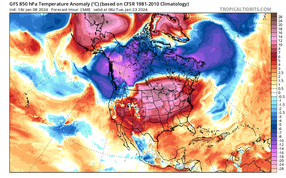
I have no hope in any +PNA in Feb, I have no care on what past El Nino's have produced given our background state has changed with the expanse of warmth in the pacific and AGW. We no longer have the temperature gradients of past events, this makes many analogs very suspect. Lets be real, we have punted all of December and all of Jan (inland and mountains look to receive a few inches before going back to zero in the cutter). This was very much a thread the needle event as the "cold" is very fleeting and we have a strung out S/W pretty well timed. However, the NYC steak of 700+ with under an inch of snow will continue and those near the coast will receive zero. I will likely hit my post limit after this so I will not be able to respond, if someone can remove my limit given I have been on these boards since inception and do not engage in personal attacks, that would be appreciative.
-
2
-
1
-


Monitoring some form of significant ( to be determined more precisely) impact winter storm, Jan 16/17th. Moderate seems to be the upper limit - for now
in New England
Posted
You had a HECS this year, if you get nothing rest of year you are good