

qg_omega
-
Posts
3,044 -
Joined
-
Last visited
Content Type
Profiles
Blogs
Forums
American Weather
Media Demo
Store
Gallery
Posts posted by qg_omega
-
-
This is mostly rain or white rain for the coast, temps are awful with a spring elevation storm vibe yet again
-
 2
2
-
 3
3
-
-
24 minutes ago, mahk_webstah said:
You loves those 300 hr op runs especially when they’re warm. Maybe this is one step in the middle of a pattern progression but do you think this is really how it’s going to play out on a larger scale?
its not like we haven't seen the SE ridge like up into the NAO region with a trough out west, o wait.
-
7 hours ago, psuhoffman said:
I waant using the gfs. I’ve been looking at the euro control and ensemble members. They have been consistently showing underwhelming temps. A couple runs ago the euro had a storm that should have been a big snow for NC/SC but was just rain. Not even close really. And the reason the snow mean isn’t lighting up more than it is for the Feb 21-24 period is that there are quite a few perfect track rainstorms within the ensemble members. The eps h5, slp, and precip look amazing. Then the snow output looks blah. The reason is the temps.
All the cold is on the other side of the pole
-
1
-
-
2 hours ago, brooklynwx99 said:
extremely potent signal on the EPS


-
2
-
-
Airmass is awful before the storm, this is clearly rain for the coast. Lots of snow goggles and fake snow maps. I still see a one week window of potential winter after the rain, then it’s over
-
 1
1
-
-
8 minutes ago, forkyfork said:
less-nao
And PNA
-
1
-
4
-
-
4 minutes ago, 40/70 Benchmark said:
Tough not to just expect everything to go wrong at this point...regardless of the pattern.
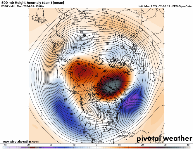
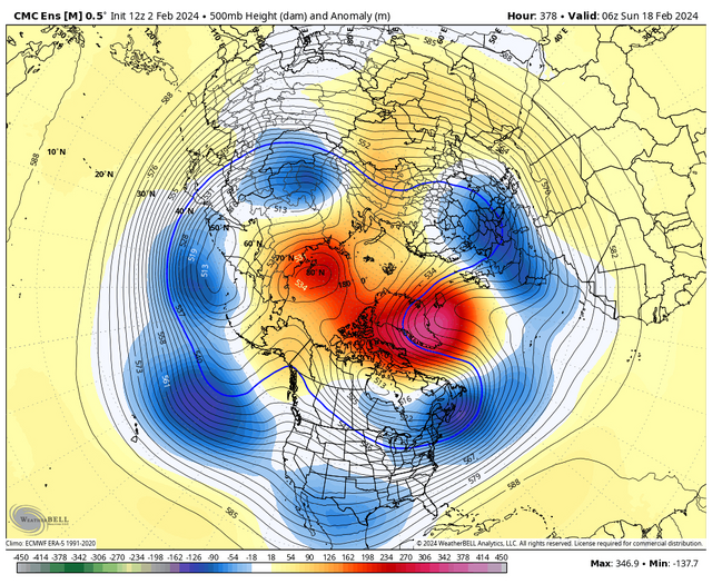
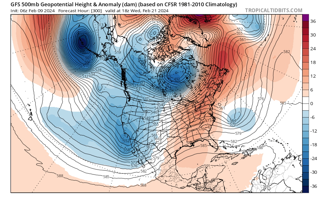
Biblical look at H5 @brooklynwx99
-
2
-
-
3 minutes ago, bluewave said:
Extended EPS trending more suppressed Feb 19-26 than previous runs. So it will probably come down to the very end of February into the first week of March to see if we get some improvement.
New run Feb 19 to 26
Old run

looks like El Nino in Jan....
-
4 minutes ago, weatherwiz said:
You can have an entire week or two or whatever period average above for temperatures...you could easily get a day or two of below-average which coincides with a storm and snow.
Like Herb Brooks said, "One game. If we played them 10 times they might win 9. But not this game. Not tonight."
We could have above average temperatures 9 out of 10 days and still come out of that stretch with a big snow event. It just takes that one day.
Insightful Wiz
-
1
-
-
Nice pattern change
-
 1
1
-
2
-
-
26 minutes ago, Allsnow said:
Epic h5 looks on ens but nothing to show for it on the op’s
we saw this before with the OPs looking meh and ens looking great at H5......
-
1
-
-
49 minutes ago, Damage In Tolland said:
I don’t follow this line of thinking .. come Feb 15th we will have lost 2.5 out of 3 winter months. The vast majority of SNE has seen 15” of snow or less. You don’t save or salvage that type of winter. It’s lost. You can however get some snow to pad the stats to make it seem or “appear” better than it was. Thats really all that we are doing/ hoping.
It’s a Rat, can’t be saved at this point with winter over in a few weeks
-
2
-
3
-
1
-
-
2 minutes ago, bluewave said:
NYC hasn’t had a 4”+ snow event since the Pacific became more hostile in 18-19 with a trough near the Baja. NYC has had 8 events of 4” or more since then. But hopefully the late February period turns out to be a first so NYC can finally end the under 2” streak.
8 storm composite for NYC of 4”+ since November 2018
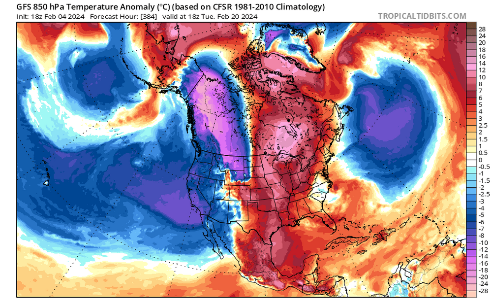
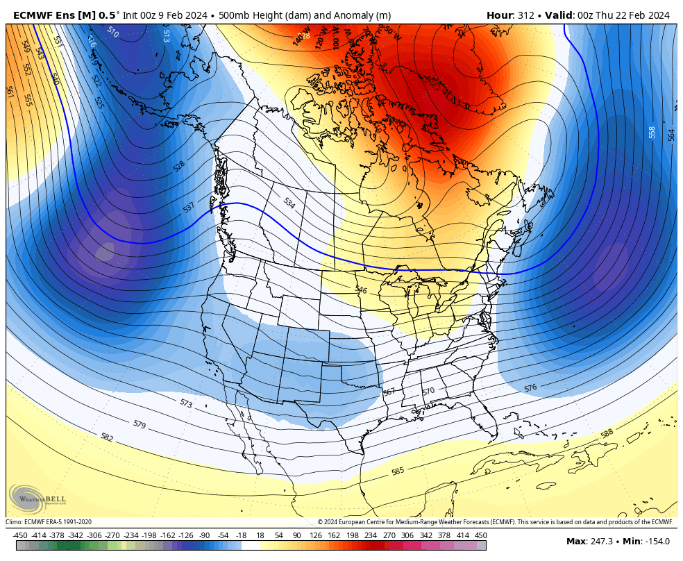
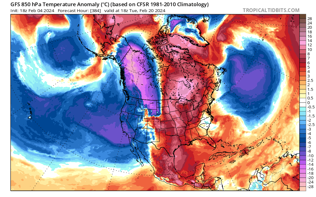
SW ridge into Rockies and 50/50 low to the east of Newfoundland.

Forecast
Can’t amplify up the coast in that pattern. Maybe mid Atlantic this works but even then the cold isn’t impressive
-
1
-
1
-
-
16 minutes ago, brooklynwx99 said:
seems like the pattern change is coming, just a matter of strength and duration. with the SPV getting obliterated and immediately coupling with the TPV, I would expect blocking to continue into early March
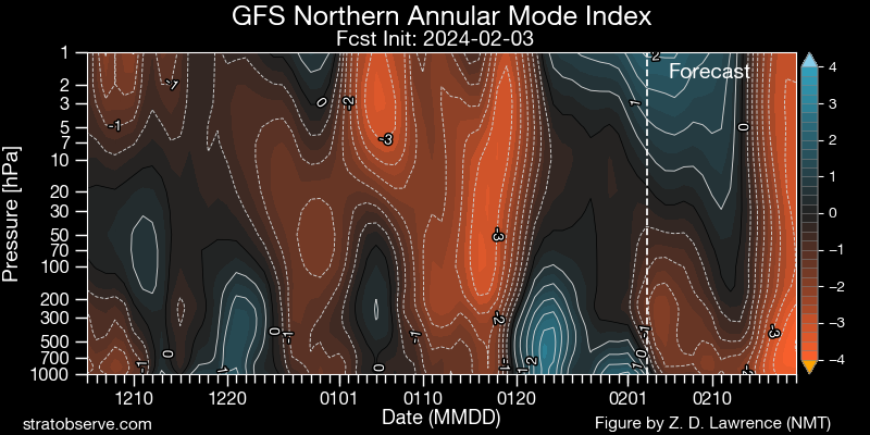
Blocking sure, cold? Doubtful with the PAC, I can see cold locking on the other side of the pole if you consider that a win
-
2
-
1
-
-
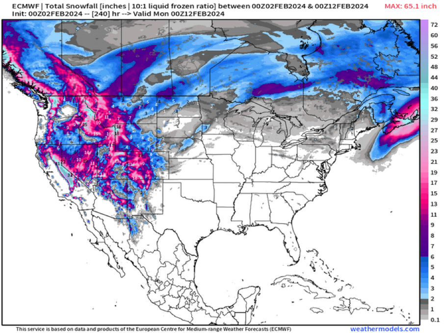
Had 28 inches, Epic overrunning storm that started early and just went.
-
4
-
-
21 hours ago, Damage In Tolland said:
That looks like all NW cold dry flow there. Theres no southern stream and it screams suppression . We’ll pass on 2 weeks of 26/15 and dry cracked ground and skin
-
3
-
-
11 minutes ago, ORH_wxman said:
What’s interesting on the 12z GEFS (and EPS was showing this as well) is that the western ridge is amplifying the entire time once it starts around D10-11. So that means you could have any number of shortwaves during this period be prone to big cyclogenesis….that’s a constructive interference look there rather than a de-amplifying ridge providing destructive interference.
I really don’t trust any of the ensembles past 10 days so I really have no expectations here until we get much closer.
-
2
-
-
Exciting times
-
4
-
3
-
-
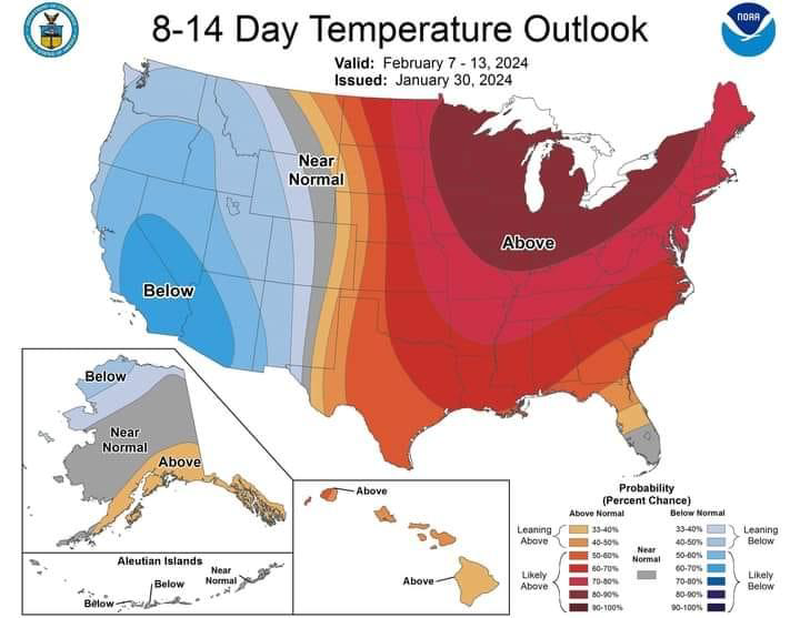
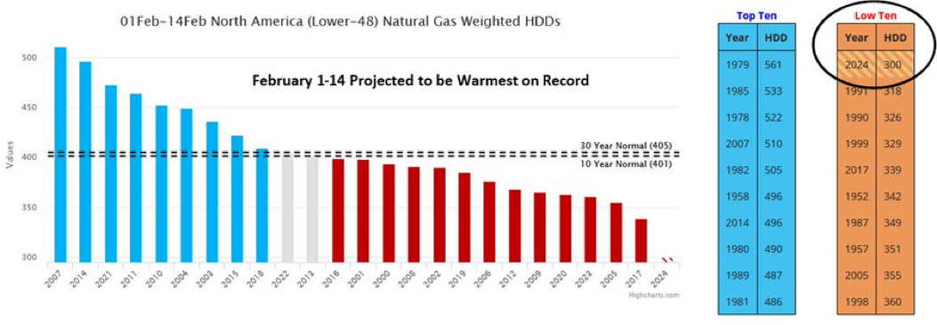
39 minutes ago, powderfreak said:
We just went +8.1F locally at MVL in January… Saint Johnsbury (1V4) with a period of record to 1800s was also +8.1F.
SLK at +7.2F… BTV +6.1 (less reliant on mins).
It turned into a +6 to +8 above normal January here. Thats pretty high-end to have temps of 30.2/17.4 for a mean up here.
@40/70 Benchmark said January wasn’t warm
-
1
-
-
29 minutes ago, 40/70 Benchmark said:
In the mean time, enjoy the break in the weather because the bulk of winter still awaits-
Very bold call, I can see a week of winter like January but longer than that seems dubious
-
1
-
1
-
1
-
-
On 1/29/2024 at 2:10 PM, qg_omega said:
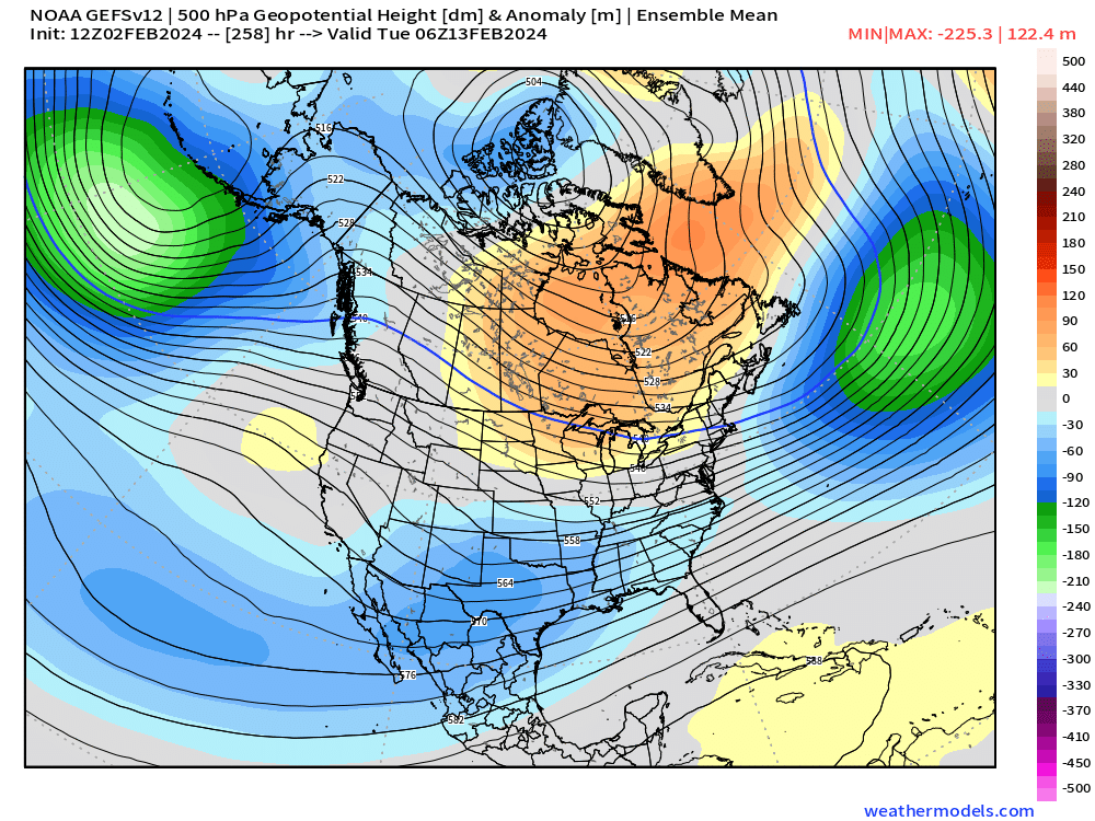
Omega block looks to roll east 2nd week of February while the weekend cold shot trends milder. One of the quietest first two weeks of February I’ve seen modeled. Makes sense we would regress a bit from the epic wet pattern of the past many months
Just pure nothingness next two weeks
-
1
-
1
-
-
8 minutes ago, 40/70 Benchmark said:
Can I honestly ask you something? If you want so badly to be taken more seriously and have the 5PPD removed, why is your presentation of data so one-sided? I understand that the past two winters have been biased warm with little snowfall, but in the past, you have simply dissapeared during severe bouts of winter weather. I have been trying to give you the benefit fo the doubt, but you make that difficult.
I only disappear when i can’t post, I’ve been on the forums for 20 years
-
7
-
-
-
2 minutes ago, 40/70 Benchmark said:
I would say if I had to point to a "smoking gun", so to speak....it would be the +EPO.....that is probably why it has been so warm. But even with the warmth, there have been chances to snow..January left a lot on the table and I still had nearly 30". I feel like have been pretty accurate with respect to the El Nino, polar fields and the PDO/PNA.
You had close to the January jackpot (all of the Northeast) wouldn’t say any was left on the table for you. NYC had 2 inches
-
1
-
1
-


It was a Flop... February 2024 Disco. Thread
in New England
Posted
It’s a another week of Winter before its over and I’m not convinced at all that everyone will score. Same areas that did well in Jan look to repeat