Blizzard of 93
-
Posts
12,842 -
Joined
-
Last visited
Content Type
Profiles
Blogs
Forums
American Weather
Media Demo
Store
Gallery
Everything posted by Blizzard of 93
-
Central PA Winter 25/26 Discussion and Obs
Blizzard of 93 replied to MAG5035's topic in Upstate New York/Pennsylvania
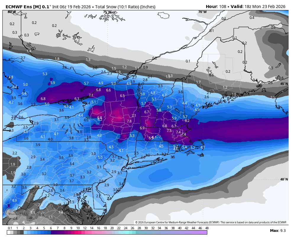
6z Euro still brings most of its snow to us from the inverted trough. It still has Warning level snow for the LSV this run. -
Central PA Winter 25/26 Discussion and Obs
Blizzard of 93 replied to MAG5035's topic in Upstate New York/Pennsylvania
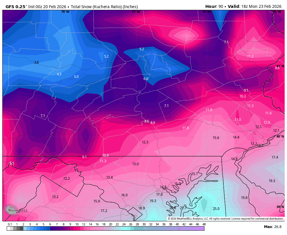
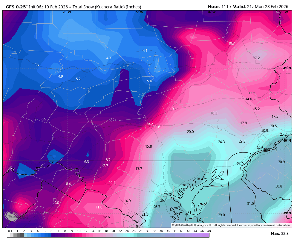
6z GFS shows another tucked low just off of OCMD, bringing heavy snow potential to the LSV again this run.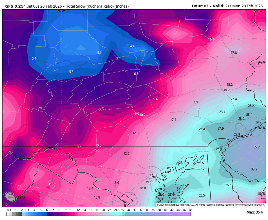
-
Central PA Winter 25/26 Discussion and Obs
Blizzard of 93 replied to MAG5035's topic in Upstate New York/Pennsylvania
Absolutely too early to call this one. Wide model discrepancy especially between the GFS & Euro. -
Central PA Winter 25/26 Discussion and Obs
Blizzard of 93 replied to MAG5035's topic in Upstate New York/Pennsylvania
0z GEFS snow -
Central PA Winter 25/26 Discussion and Obs
Blizzard of 93 replied to MAG5035's topic in Upstate New York/Pennsylvania
Thanks to @Newman for showing the improvement on the 0z GEFS over its 18z run. -
Central PA Winter 25/26 Discussion and Obs
Blizzard of 93 replied to MAG5035's topic in Upstate New York/Pennsylvania
-
Central PA Winter 25/26 Discussion and Obs
Blizzard of 93 replied to MAG5035's topic in Upstate New York/Pennsylvania
Way too soon for numbers. It will all come down to banding & rates. -
Central PA Winter 25/26 Discussion and Obs
Blizzard of 93 replied to MAG5035's topic in Upstate New York/Pennsylvania
Another beautiful GFS run.
-
Central PA Winter 25/26 Discussion and Obs
Blizzard of 93 replied to MAG5035's topic in Upstate New York/Pennsylvania
Nice 18z GEFS uptick in the snow map to correspond with the low clusters. -
Central PA Winter 25/26 Discussion and Obs
Blizzard of 93 replied to MAG5035's topic in Upstate New York/Pennsylvania
Definitely a step in the right direction -
Central PA Winter 25/26 Discussion and Obs
Blizzard of 93 replied to MAG5035's topic in Upstate New York/Pennsylvania
0z NBM & NBM Para both show Warning level snow potential in the LSV. -
Central PA Winter 25/26 Discussion and Obs
Blizzard of 93 replied to MAG5035's topic in Upstate New York/Pennsylvania
The 18z EPS snow map had a solid uptick as well at 18z over 12z.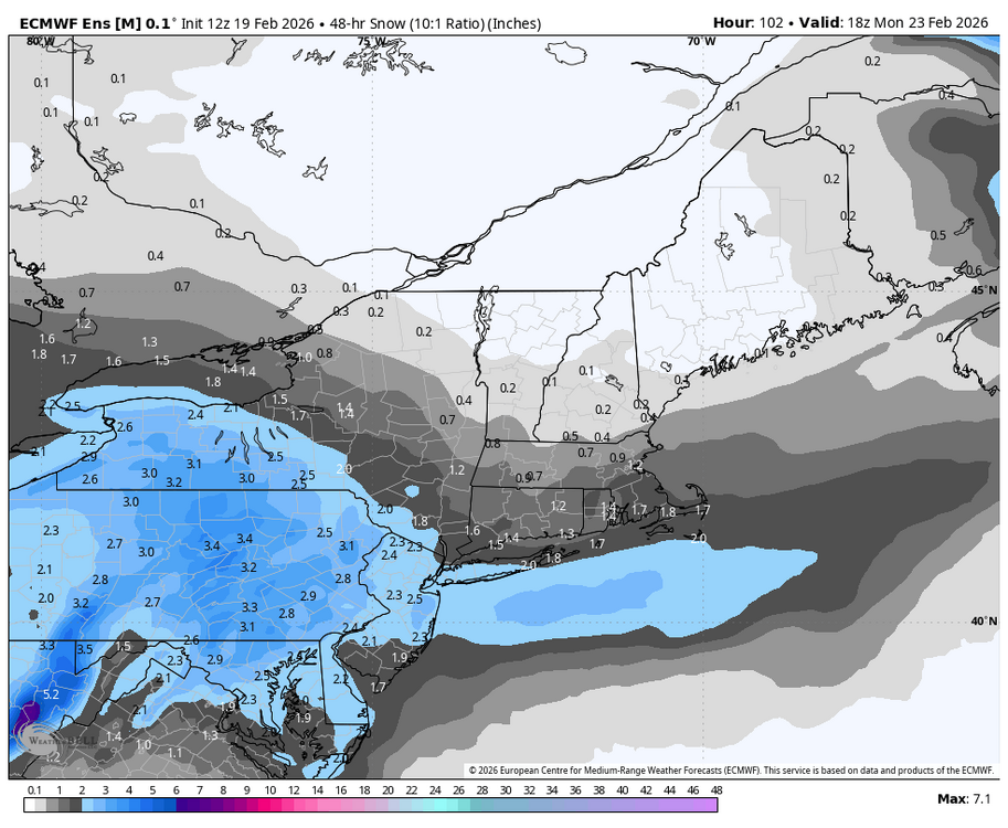
-
Central PA Winter 25/26 Discussion and Obs
Blizzard of 93 replied to MAG5035's topic in Upstate New York/Pennsylvania
18z EPS had a significant jump west over its 12z run. That’s a few hundred miles in one run. We still need a little more to get into GFS territory, but you rarely see the EPS jump this much so close to game time. -
Central PA Winter 25/26 Discussion and Obs
Blizzard of 93 replied to MAG5035's topic in Upstate New York/Pennsylvania
Great to see this unexpected turn of events… usually it’s the other way around! 0z will be interesting to say the least! -
Central PA Winter 25/26 Discussion and Obs
Blizzard of 93 replied to MAG5035's topic in Upstate New York/Pennsylvania
Absolutely, unbelievable that it won’t back down!
-
Central PA Winter 25/26 Discussion and Obs
Blizzard of 93 replied to MAG5035's topic in Upstate New York/Pennsylvania
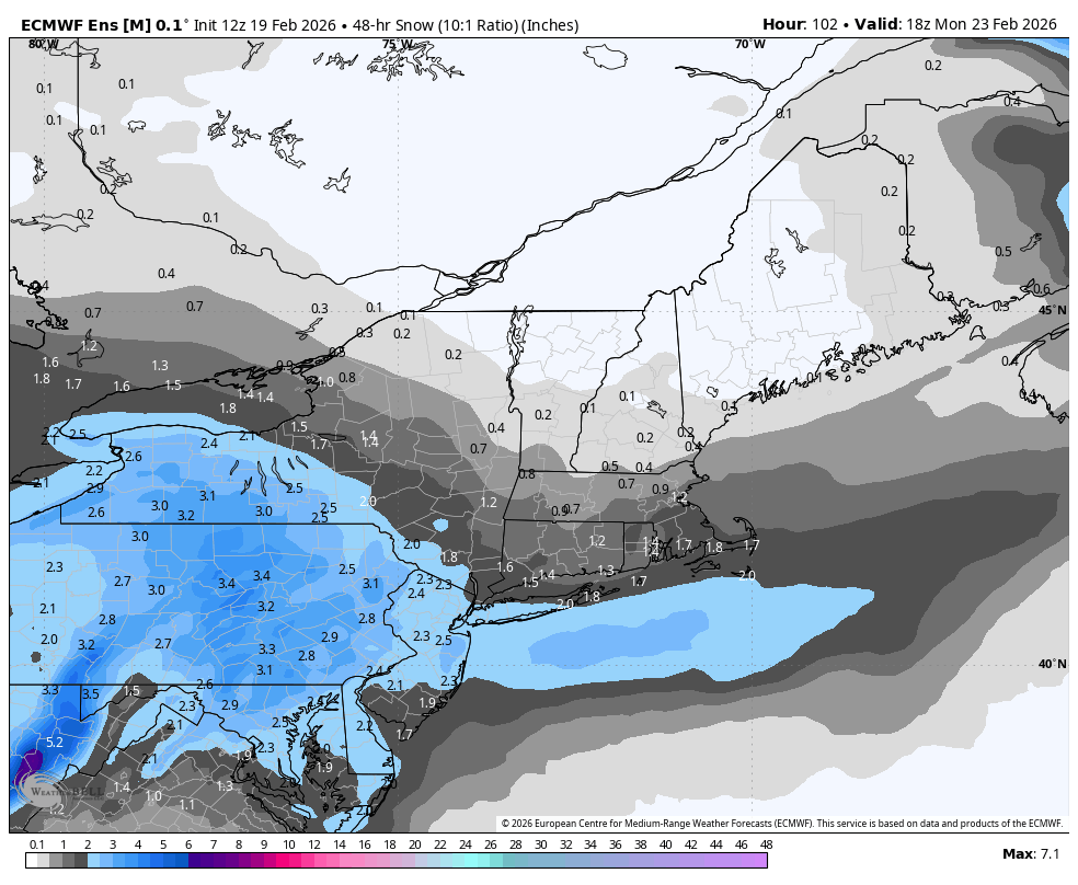
Checking in over lunch time & the 12z Euro agrees mostly with your current thoughts. It is remarkable that the GFS doubled down at 12z. Even half of that run would be great to see. This Euro run we get a few inches from the initial coastal low before it heads east. Then the LSV gets bullseyed with the Norlun Sunday night & tacks in a few more inches. In total, this run still brings Warning level snow to most of the LSV. Maybe a compromise of some kind will still take place before game time? Here is the 12z Euro.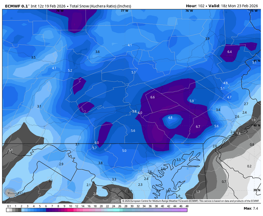
-
Central PA Winter 25/26 Discussion and Obs
Blizzard of 93 replied to MAG5035's topic in Upstate New York/Pennsylvania
6z GEFS, EPS & AI EPS agree on at least a solid Advisory level snow for us this Sunday into Monday.
-
Central PA Winter 25/26 Discussion and Obs
Blizzard of 93 replied to MAG5035's topic in Upstate New York/Pennsylvania
A compromise between the Euro & GFS would deliver a significant event to many of us. -
Central PA Winter 25/26 Discussion and Obs
Blizzard of 93 replied to MAG5035's topic in Upstate New York/Pennsylvania
The 6z Euro gets a Warning level event to a good chunk of the LSV thanks to the Norlun trough setting up over our region.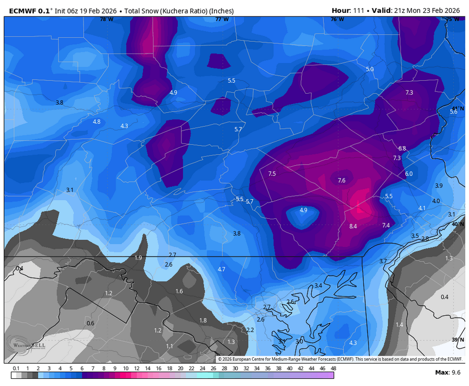
-
Central PA Winter 25/26 Discussion and Obs
Blizzard of 93 replied to MAG5035's topic in Upstate New York/Pennsylvania
The 6z GFS was likely the best case scenario & low likelihood of verifying, but my goodness is it beautiful for Sunday. Just 1 time could it be right?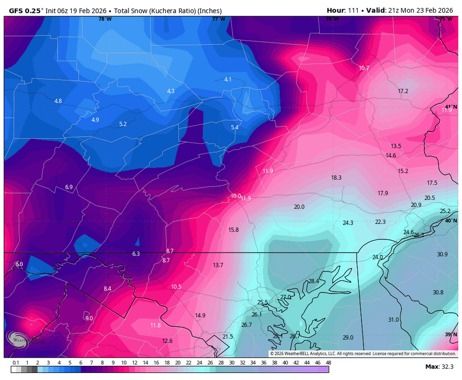
-
Central PA Winter 25/26 Discussion and Obs
Blizzard of 93 replied to MAG5035's topic in Upstate New York/Pennsylvania
The 0z Canadian gets a healthy coastal low going off of the coast of Norfolk, but then it slides mostly east from there as it intensifies. The LSV gets some snow from the coastal & then tacks on from the Norlun as the storm exits east. Long way to go, but I like seeing the 0z GFS & Canadian keeping us in the game for a Warning level chance. I think the odds of an Advisory level event for us are certainly increasing. -
Central PA Winter 25/26 Discussion and Obs
Blizzard of 93 replied to MAG5035's topic in Upstate New York/Pennsylvania
If this low track were to verify as the low intensifies heading northward, heavier snow would push further back into CTP. -
Central PA Winter 25/26 Discussion and Obs
Blizzard of 93 replied to MAG5035's topic in Upstate New York/Pennsylvania
Absolutely, great to see 2 good runs in a row by the GFS. -
Central PA Winter 25/26 Discussion and Obs
Blizzard of 93 replied to MAG5035's topic in Upstate New York/Pennsylvania
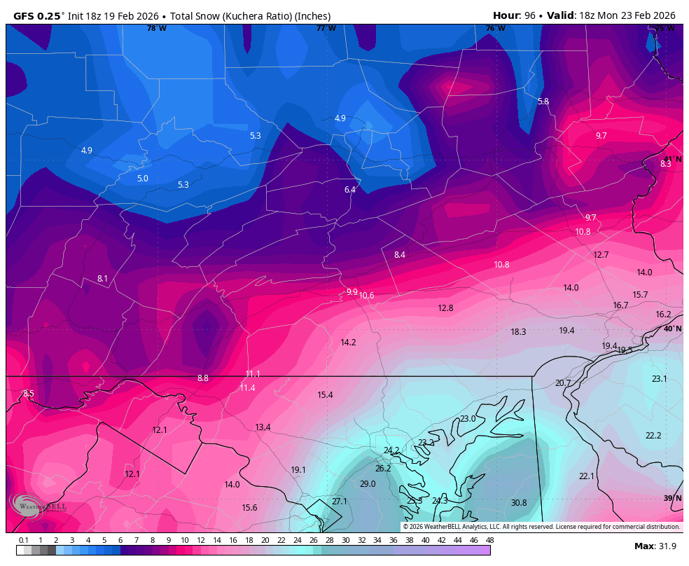
Where do we sign up for the 18z GFS to please verify for Sunday?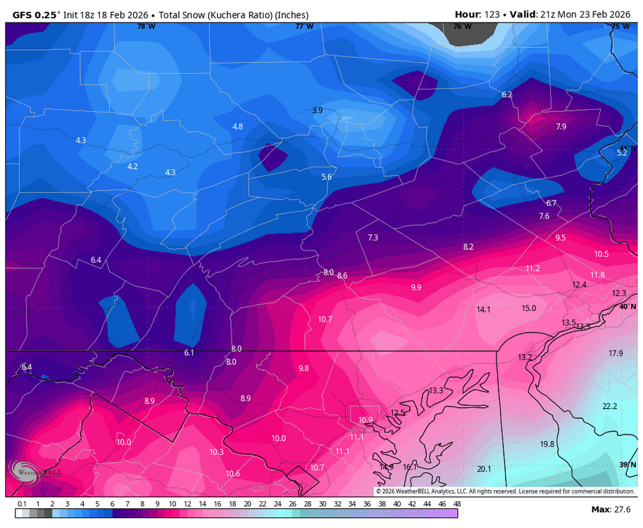
-
Central PA Winter 25/26 Discussion and Obs
Blizzard of 93 replied to MAG5035's topic in Upstate New York/Pennsylvania
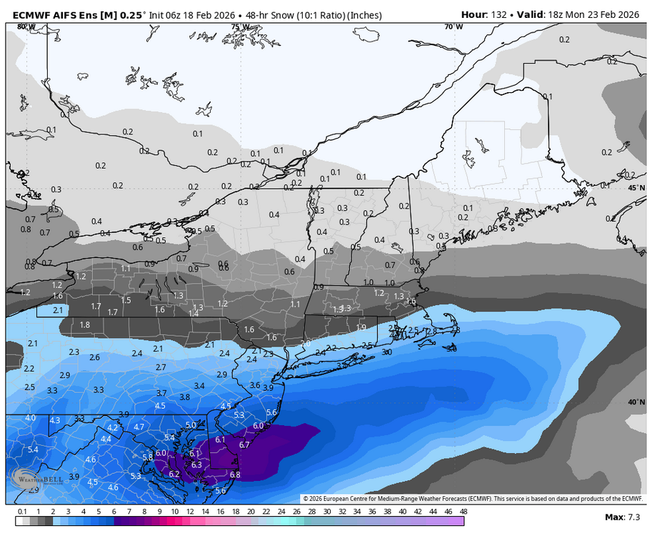
Here is the 6z AI EPS 48 hour snow through Monday.