Blizzard of 93
-
Posts
13,024 -
Joined
-
Last visited
Content Type
Profiles
Blogs
Forums
American Weather
Media Demo
Store
Gallery
Everything posted by Blizzard of 93
-
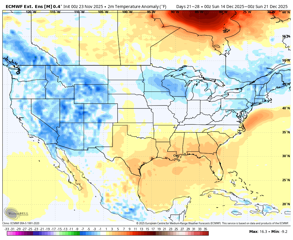
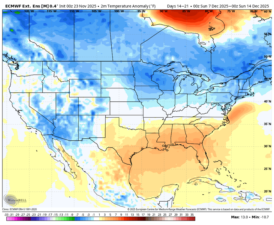
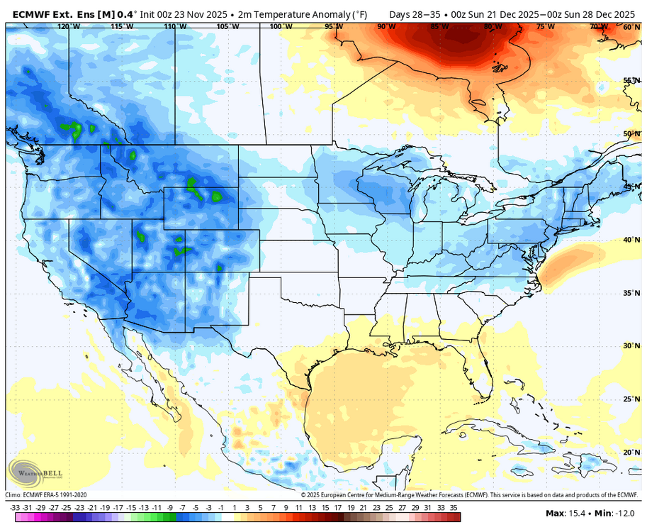
Plenty of cold available on today’s Euro Weeklies from week 2 through 6.
-
It’s really outrageous that some people already should consider taking a break for a few days before Winter even starts. The same posters were very optimistic 2 days ago… A few weather tweets that aren’t epic & suddenly a couple of folks are ready to cliff dive, Lol!
-
Central PA Fall Discussions and Obs
Blizzard of 93 replied to ChescoWx's topic in Upstate New York/Pennsylvania
I like seeing High pressure set up in southern Quebec to feed in the cold. -
Central PA Fall Discussions and Obs
Blizzard of 93 replied to ChescoWx's topic in Upstate New York/Pennsylvania
The 0z Euro & GFS now show a chance out on December 4th. Hopefully that’s the beginning of the Winter tracking fun & games. -
If we roll through phase 7, 8 and 1 later in December, we should have a pattern with chances to score Winter weather.
-
Lol, someone please tell me how this is not good … EPS is still on track for cold to be entrenched by December 5th.
-
30 day temps on the Weeklies beginning on the 5th look good as well.
-
Exactly, when you start the 30 day on the 5th, you factor out the last few days of the SE ridge in early December.
-
Central PA Fall Discussions and Obs
Blizzard of 93 replied to ChescoWx's topic in Upstate New York/Pennsylvania
Agreed, hopefully we are tracking specific winter storm chances as we get into early December. -
Central PA Fall Discussions and Obs
Blizzard of 93 replied to ChescoWx's topic in Upstate New York/Pennsylvania
The advertised better pattern looks to be on track beginning around December 5th on the 0z EPS & 0z GEFS. -
The advertised better pattern looks to be on track beginning around December 5th on the 0z EPS & 0z GEFS.
-
Central PA Fall Discussions and Obs
Blizzard of 93 replied to ChescoWx's topic in Upstate New York/Pennsylvania
The pattern progression was evident on the 12z EPS & GEFS today. By December 5th, a favorable pattern with winter storm chances should emerge if the advertised looks on the ensembles & weeklies come to fruition. -
Central PA Fall Discussions and Obs
Blizzard of 93 replied to ChescoWx's topic in Upstate New York/Pennsylvania
The models backed off of that next weekend storm idea for now. Let’s see if it shows back up or not. -
Central PA Fall Discussions and Obs
Blizzard of 93 replied to ChescoWx's topic in Upstate New York/Pennsylvania
Lol, this year’s party is just getting started. It’s very early, so anything we get before mid December is gravy. -
Central PA Fall Discussions and Obs
Blizzard of 93 replied to ChescoWx's topic in Upstate New York/Pennsylvania
Frosty & foggy 33 in Marysville this morning. -
Central PA Fall Discussions and Obs
Blizzard of 93 replied to ChescoWx's topic in Upstate New York/Pennsylvania
The 0z Euro shows it. -
Central PA Fall Discussions and Obs
Blizzard of 93 replied to ChescoWx's topic in Upstate New York/Pennsylvania
The 12z GFS was rather interesting for a couple of days after Thanksgiving. -
Central PA Fall Discussions and Obs
Blizzard of 93 replied to ChescoWx's topic in Upstate New York/Pennsylvania
Congrats to everyone that got on the board overnight! Hopefully it’s the first event of many for our group on here! -
Central PA Fall Discussions and Obs
Blizzard of 93 replied to ChescoWx's topic in Upstate New York/Pennsylvania
39 & rain in Marysville with maybe a stray flake mixed in if I squint enough. -
Central PA Fall Discussions and Obs
Blizzard of 93 replied to ChescoWx's topic in Upstate New York/Pennsylvania
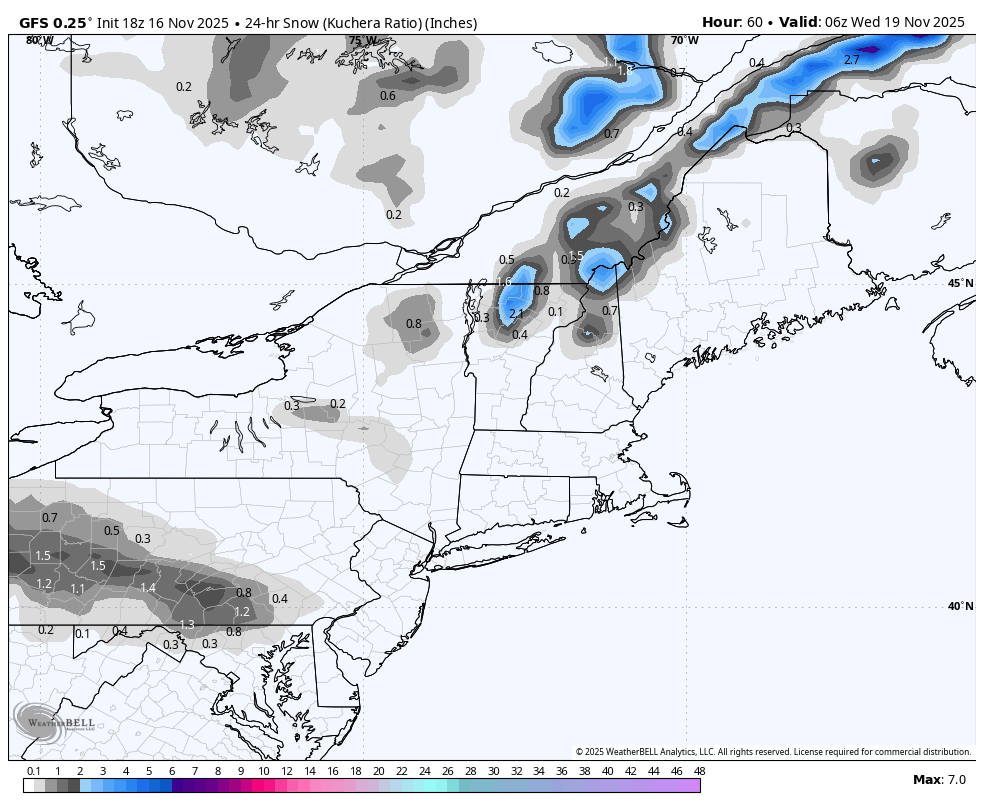
18z GFS has a little light snow showing this run on Tuesday early evening for the LSV with a weak wave.
-
Central PA Fall Discussions and Obs
Blizzard of 93 replied to ChescoWx's topic in Upstate New York/Pennsylvania
This wind means business today. Advisory is for real. -
Central PA Fall Discussions and Obs
Blizzard of 93 replied to ChescoWx's topic in Upstate New York/Pennsylvania
@sauss06 maybe would lend a hand as well? I am already done with wind this Fall. -
Central PA Fall Discussions and Obs
Blizzard of 93 replied to ChescoWx's topic in Upstate New York/Pennsylvania
The darn wind woke me up around 4 am. Hopefully my trash cans are not currently in the river! -
Central PA Fall Discussions and Obs
Blizzard of 93 replied to ChescoWx's topic in Upstate New York/Pennsylvania
Great early season storm! It started as a little rain & wet snow in the LSV. The heavy precip band arrived in the late morning & the snow rates became heavy by around noon & persisted until early evening. I think we got 8 or 9” of snow. Many people went to work because it didn’t start until mid morning & most forecasts were for maybe a slushy few inches on grassy surfaces. The heavy rates meant business & it was one of the worst commutes home for me. I-81 was a nightmare that afternoon in the Harrisburg area with many accidents. -
Central PA Fall Discussions and Obs
Blizzard of 93 replied to ChescoWx's topic in Upstate New York/Pennsylvania
The 18z GFS really got into the happy hour good stuff today. It shows the first chance on the 18th & then another long shot on Turkey Day Eve. I’m so happy digital snow tracking season is upon us, Lol!