Blizzard of 93
-
Posts
12,861 -
Joined
-
Last visited
Content Type
Profiles
Blogs
Forums
American Weather
Media Demo
Store
Gallery
Everything posted by Blizzard of 93
-
Central PA - Jan 31 to Feb 2 Winter Storm
Blizzard of 93 replied to MAG5035's topic in Upstate New York/Pennsylvania
Ok, wrong thread....but did everyone see the 12z Euro for Next weekend?! It has a Miller A coming out of the gulf heading right up the east coast. This could be a memorable Winter week. This snow map is ONLY for the potential storm Next weekend.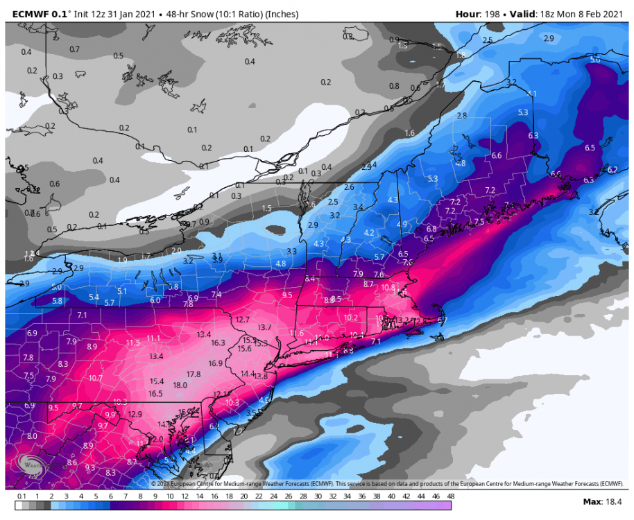
-
Central PA - Jan 31 to Feb 2 Winter Storm
Blizzard of 93 replied to MAG5035's topic in Upstate New York/Pennsylvania
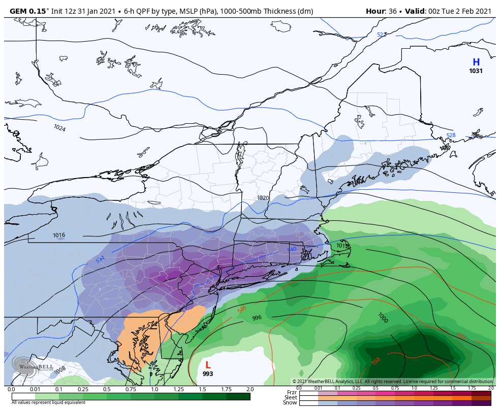
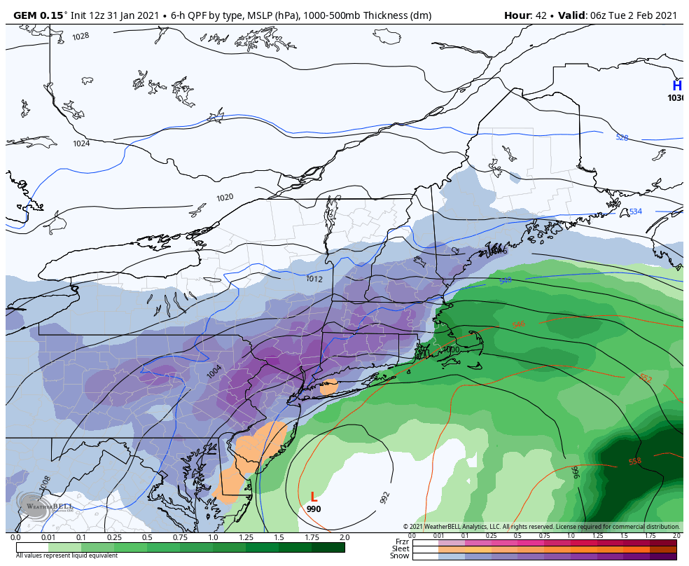
The 0z NAM really caught on, my Goodness! Look at that QPF & the snow is now Euro like for the Susquehanna Valley. -
Central PA - Jan 31 to Feb 2 Winter Storm
Blizzard of 93 replied to MAG5035's topic in Upstate New York/Pennsylvania
It’s about time! -
Central PA - Jan 31 to Feb 2 Winter Storm
Blizzard of 93 replied to MAG5035's topic in Upstate New York/Pennsylvania
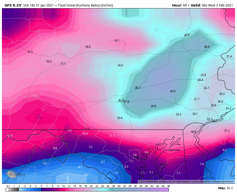
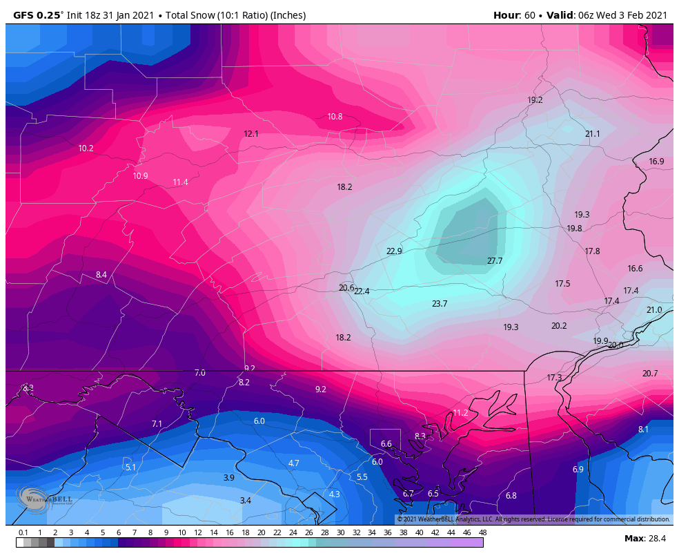
Yes, the 18z Euro did Not back down for the Susquehanna Valley. It still stalls the low and snows on us until Tuesday. Here is QPF, 10-1 & Kuchera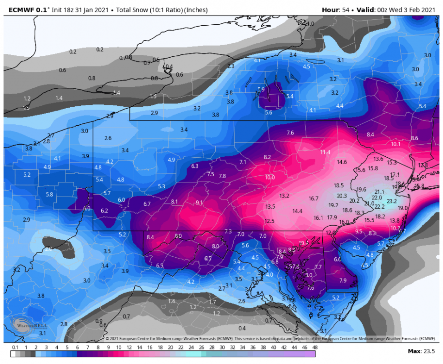
-
Central PA - Jan 31 to Feb 2 Winter Storm
Blizzard of 93 replied to MAG5035's topic in Upstate New York/Pennsylvania
It’s a little late in the for ensembles, but the 18z GEFS agreed with the Op and gets the Susquehanna Valley back in the game for the good stuff!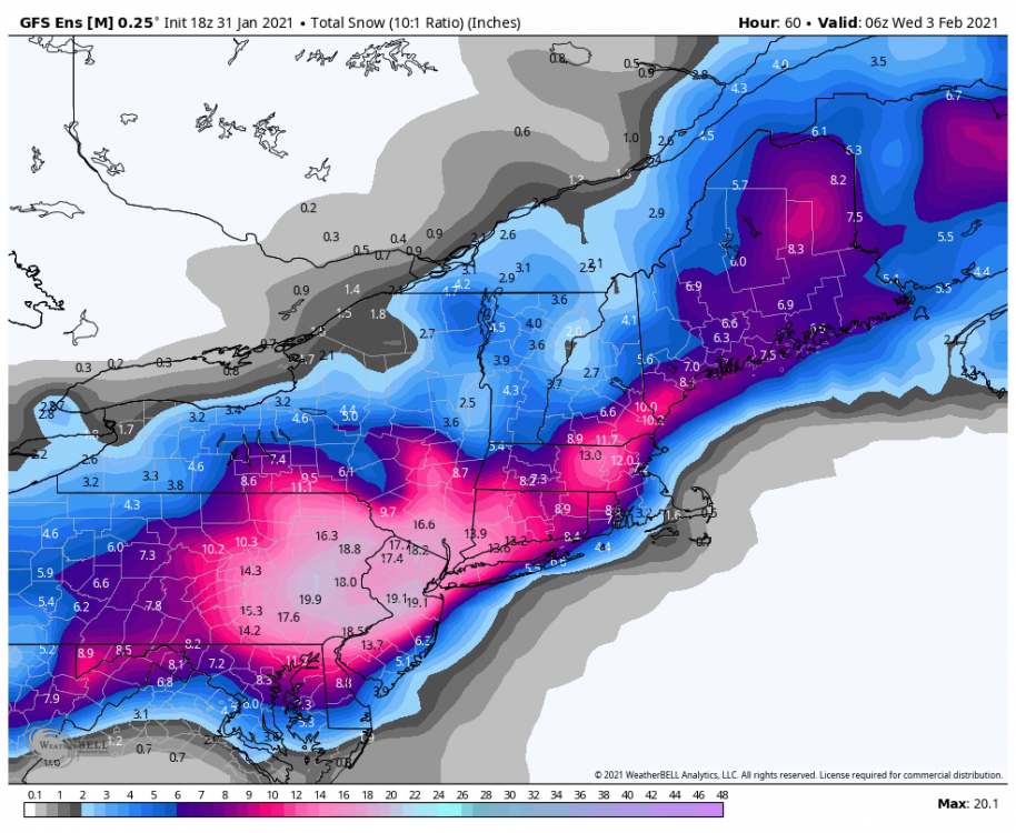
-
Central PA - Jan 31 to Feb 2 Winter Storm
Blizzard of 93 replied to MAG5035's topic in Upstate New York/Pennsylvania
Same here right up the road from you in Marysville. I have a little over 2 inches on the ground and steady snow continues. -
Central PA - Jan 31 to Feb 2 Winter Storm
Blizzard of 93 replied to MAG5035's topic in Upstate New York/Pennsylvania
Yes indeed, hopefully the 18z Euro will agree with the GFS. We will find out around 7pm! -
Central PA - Jan 31 to Feb 2 Winter Storm
Blizzard of 93 replied to MAG5035's topic in Upstate New York/Pennsylvania
The 18z GFS puts the Harrisburg, York, & Lancaster crew right back in the bullseye! Long way to go, but this was great to see the high end option remains on the table! Here is the 10-1 & Kuchera map 18z GFS.

-
Central PA - Jan 31 to Feb 2 Winter Storm
Blizzard of 93 replied to MAG5035's topic in Upstate New York/Pennsylvania
It’s a roller coaster with CTP... I sure their forecast will change five more times before the event is done. The results will probably be right around where they started out earlier today. -
Central PA - Jan 31 to Feb 2 Winter Storm
Blizzard of 93 replied to MAG5035's topic in Upstate New York/Pennsylvania
If they are relying on the long range HRRR....I don’t know what to say....but they are the experts, so we will see how it goes. -
Central PA - Jan 31 to Feb 2 Winter Storm
Blizzard of 93 replied to MAG5035's topic in Upstate New York/Pennsylvania
This might be the best post of the day! 100% great point. -
Central PA - Jan 31 to Feb 2 Winter Storm
Blizzard of 93 replied to MAG5035's topic in Upstate New York/Pennsylvania
Exactly, we are in the second inning of this ballgame! -
Central PA - Jan 31 to Feb 2 Winter Storm
Blizzard of 93 replied to MAG5035's topic in Upstate New York/Pennsylvania
I agree. Rates are picking up now in Marysville. I have a little over 1 inch of snow on the ground. -
Central PA - Jan 31 to Feb 2 Winter Storm
Blizzard of 93 replied to MAG5035's topic in Upstate New York/Pennsylvania
Someone will get crushed if this low stalls out like the Euro shows. Steady snow still ongoing at 10 am Tuesday in The LSV.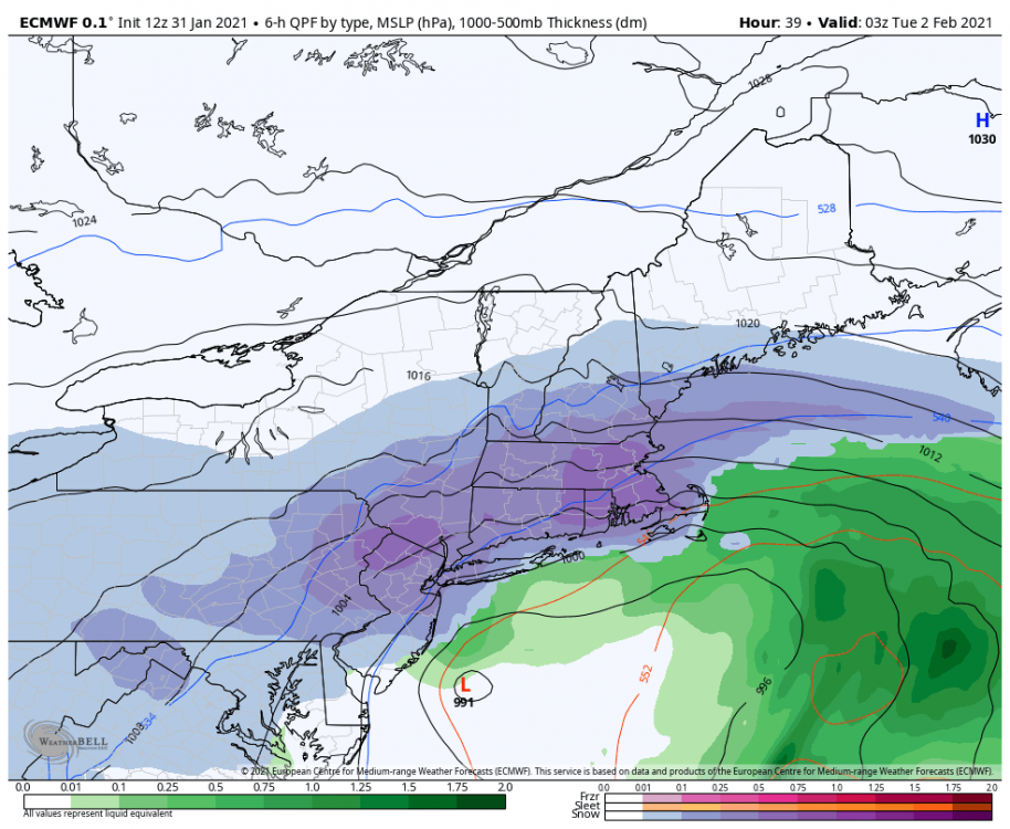
-
Central PA - Jan 31 to Feb 2 Winter Storm
Blizzard of 93 replied to MAG5035's topic in Upstate New York/Pennsylvania
@MAG5035 Please let us you your thoughts on ratios once the coastal gets going? -
Central PA - Jan 31 to Feb 2 Winter Storm
Blizzard of 93 replied to MAG5035's topic in Upstate New York/Pennsylvania
Please see the map above... If MDT gets 19 inches, that is a top 10 storm. -
Central PA - Jan 31 to Feb 2 Winter Storm
Blizzard of 93 replied to MAG5035's topic in Upstate New York/Pennsylvania
Look at the map that I just posted! Here it is AGAIN! It shows consistent amounts over 16 inches from Johnstown to Philly! -
Central PA - Jan 31 to Feb 2 Winter Storm
Blizzard of 93 replied to MAG5035's topic in Upstate New York/Pennsylvania
This won’t be 10-1 once the coastal takes over and stalls out -
Central PA - Jan 31 to Feb 2 Winter Storm
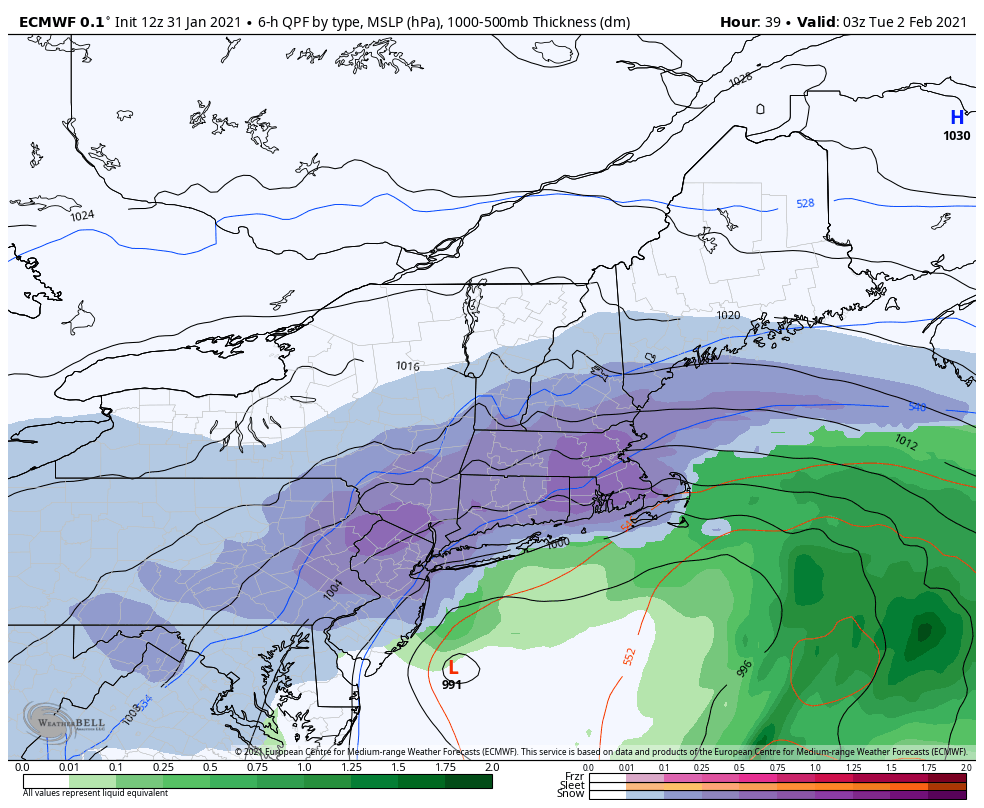
Blizzard of 93 replied to MAG5035's topic in Upstate New York/Pennsylvania
The low on the 12z Euro stalls out tomorrow afternoon off of the south NJ coast and stays there until 4 am Tuesday and then drifts South Tuesday am! -
Central PA - Jan 31 to Feb 2 Winter Storm
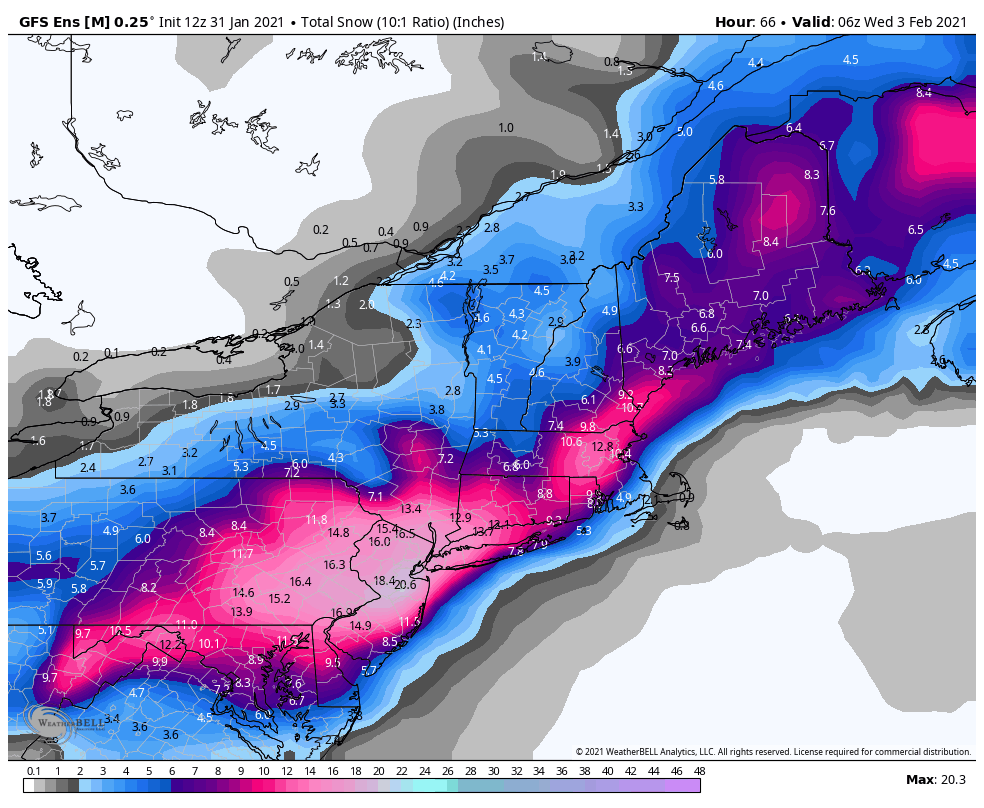
Blizzard of 93 replied to MAG5035's topic in Upstate New York/Pennsylvania
12z Euro...First, here is what everyone wants to see... Snow & QPF ( I heard there was a contest...!)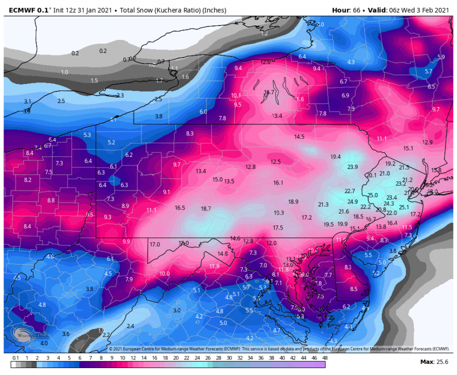
-
Central PA - Jan 31 to Feb 2 Winter Storm
Blizzard of 93 replied to MAG5035's topic in Upstate New York/Pennsylvania
???? Great Euro Run!!! -
Central PA - Jan 31 to Feb 2 Winter Storm
Blizzard of 93 replied to MAG5035's topic in Upstate New York/Pennsylvania
Accuweather has this latest snow map. It looks like 12-18 for many of us. DD213D30-0780-4CA7-AE75-B4BE8AD7EC38.webp -
Central PA - Jan 31 to Feb 2 Winter Storm
Blizzard of 93 replied to MAG5035's topic in Upstate New York/Pennsylvania
The 12z GEFS still delivers 12 to 15 inches of snow to the LSV, which is strong for an ensemble run.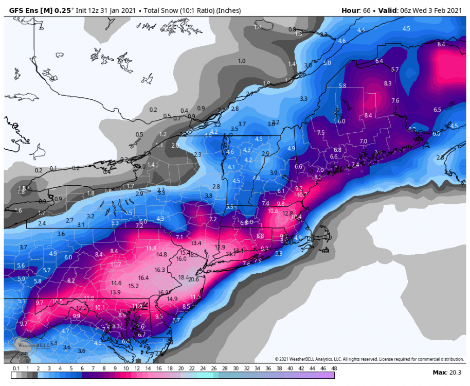
-
Central PA - Jan 31 to Feb 2 Winter Storm
Blizzard of 93 replied to MAG5035's topic in Upstate New York/Pennsylvania
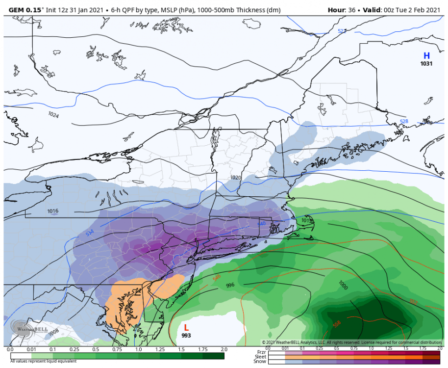
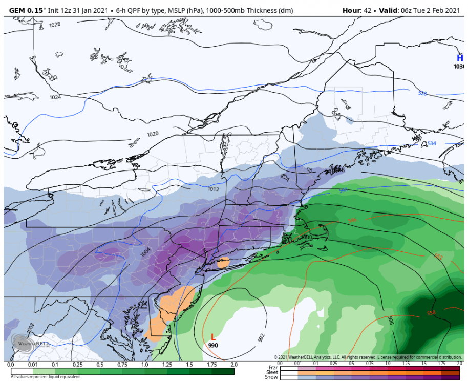
The hour 48 frame on the Canadian is what I was referring to in my post a few minutes ago about the banding & what @Itstrainingtime was just mentioning about lots of moving parts, etc. The location of the best bands will ultimately decide who jackpots with the higher amount and who “settles” for closer to 10 inches of snow. -
Central PA - Jan 31 to Feb 2 Winter Storm
Blizzard of 93 replied to MAG5035's topic in Upstate New York/Pennsylvania
Here are a few frames from the 12z Canadian. We have a long way to go!