Blizzard of 93
-
Posts
13,087 -
Joined
-
Last visited
Content Type
Profiles
Blogs
Forums
American Weather
Media Demo
Store
Gallery
Everything posted by Blizzard of 93
-
Central PA Winter 25/26 Discussion and Obs
Blizzard of 93 replied to MAG5035's topic in Upstate New York/Pennsylvania
It is still going… -
Central PA Winter 25/26 Discussion and Obs
Blizzard of 93 replied to MAG5035's topic in Upstate New York/Pennsylvania
Hour 75 the coastal gets cranking off of the DelMarVa . Only southeast Lanco has a touch of sleet mix. All snow for 98% of CTP -
Central PA Winter 25/26 Discussion and Obs
Blizzard of 93 replied to MAG5035's topic in Upstate New York/Pennsylvania
GFS is a mauling for all of us Hour 72 -
Central PA Winter 25/26 Discussion and Obs
Blizzard of 93 replied to MAG5035's topic in Upstate New York/Pennsylvania
Hour 63 we are getting moderate snow across the southern half of PA. -
Central PA Winter 25/26 Discussion and Obs
Blizzard of 93 replied to MAG5035's topic in Upstate New York/Pennsylvania
I have 17 minutes to get my MDT prediction in… -
Central PA Winter 25/26 Discussion and Obs
Blizzard of 93 replied to MAG5035's topic in Upstate New York/Pennsylvania
Or just ignore the worthless ICON? -
Central PA Winter 25/26 Discussion and Obs
Blizzard of 93 replied to MAG5035's topic in Upstate New York/Pennsylvania
Great to see CTP on board for a major event as of this evening. -
Central PA Winter 25/26 Discussion and Obs
Blizzard of 93 replied to MAG5035's topic in Upstate New York/Pennsylvania
18z Euro snow- CTP close up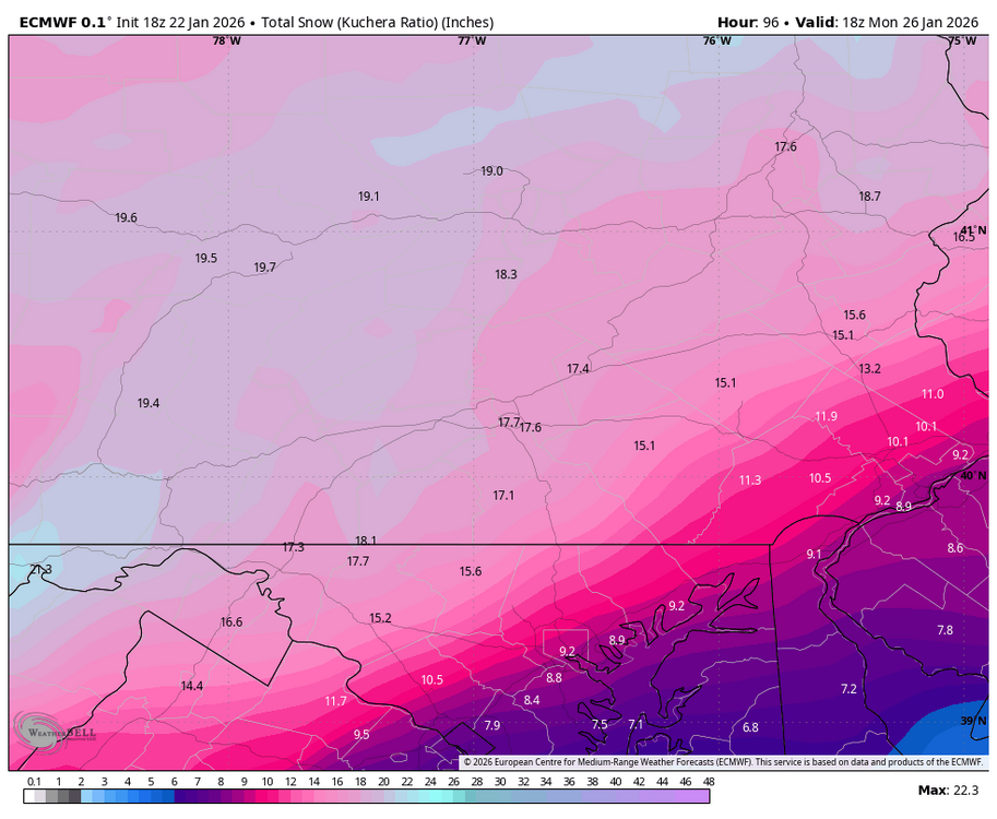
-
Central PA Winter 25/26 Discussion and Obs
Blizzard of 93 replied to MAG5035's topic in Upstate New York/Pennsylvania
Indeed! These 2 panels are beautiful -
Central PA Winter 25/26 Discussion and Obs
Blizzard of 93 replied to MAG5035's topic in Upstate New York/Pennsylvania
Maybe in extreme southeast Lanco… -
Central PA Winter 25/26 Discussion and Obs
Blizzard of 93 replied to MAG5035's topic in Upstate New York/Pennsylvania
Lol, asking for a friend, can’t it close at 1 am ? (He wants to see the 0z Euro…) -
Central PA Winter 25/26 Discussion and Obs
Blizzard of 93 replied to MAG5035's topic in Upstate New York/Pennsylvania
Latest National Blends are very nice! -
Central PA Winter 25/26 Discussion and Obs
Blizzard of 93 replied to MAG5035's topic in Upstate New York/Pennsylvania
WGAL got it right… -
Central PA Winter 25/26 Discussion and Obs
Blizzard of 93 replied to MAG5035's topic in Upstate New York/Pennsylvania
This is not right if you include 2 day totals. I know for a fact that Feb 1st 2021 started the evening of Jan 31st and we had a few inches, then the clocked turned midnight & the rest was on Feb 1st. -
Central PA Winter 25/26 Discussion and Obs
Blizzard of 93 replied to MAG5035's topic in Upstate New York/Pennsylvania
6z Euro is another burial. Southern tier mixes at the end this run, but only after 15 inches is on the ground. -
Central PA Winter 25/26 Discussion and Obs
Blizzard of 93 replied to MAG5035's topic in Upstate New York/Pennsylvania
Believe me, it’s ok to discount the Icon, lol. -
Central PA Winter 25/26 Discussion and Obs
Blizzard of 93 replied to MAG5035's topic in Upstate New York/Pennsylvania
6z GFS is the best snow amount Op run since back when this storm showed last week when we were still in fantasy land. This would be a top 10 storm at MDT if it somehow verified. -
Central PA Winter 25/26 Discussion and Obs
Blizzard of 93 replied to MAG5035's topic in Upstate New York/Pennsylvania
I’m he ICON is the worst model, so not worried whatever it shows. Euro & GFS & Euro AI along with their ensembles all show us getting buried. If the southern tier mixes at the end, it would likely be after a foot is on the ground. -
Central PA Winter 25/26 Discussion and Obs
Blizzard of 93 replied to MAG5035's topic in Upstate New York/Pennsylvania
National Blends at 3z also look great. -
Central PA Winter 25/26 Discussion and Obs
Blizzard of 93 replied to MAG5035's topic in Upstate New York/Pennsylvania
Ukie looking good too for us. -
Central PA Winter 25/26 Discussion and Obs
Blizzard of 93 replied to MAG5035's topic in Upstate New York/Pennsylvania
I love the chance of a long duration crushing storm. If this track holds, just imagine what the RGEM & NAM will show. -
Central PA Winter 25/26 Discussion and Obs
Blizzard of 93 replied to MAG5035's topic in Upstate New York/Pennsylvania
0z GFS is now matching the Euro & delivering 16 to 18 to many of us. -
Central PA Winter 25/26 Discussion and Obs
Blizzard of 93 replied to MAG5035's topic in Upstate New York/Pennsylvania
This is the height of he storm on the GFS for us! Crushed -
Central PA Winter 25/26 Discussion and Obs
Blizzard of 93 replied to MAG5035's topic in Upstate New York/Pennsylvania
If anyone wants to have some extreme snow map fun, check out today’s Euro Weeklies & Weeklies Control for the next 32 and 46 days. I am not going to post them because I don’t want to muddy the waters with this current storm. But, my goodness they are truly impressive amounts. Bottom line is that this Sunday’s storm could just be the beginning of a great remainder of this Winter. -
Central PA Winter 25/26 Discussion and Obs
Blizzard of 93 replied to MAG5035's topic in Upstate New York/Pennsylvania
Indeed