Blizzard of 93
-
Posts
12,938 -
Joined
-
Last visited
Content Type
Profiles
Blogs
Forums
American Weather
Media Demo
Store
Gallery
Everything posted by Blizzard of 93
-
Central PA Winter 25/26 Discussion and Obs
Blizzard of 93 replied to MAG5035's topic in Upstate New York/Pennsylvania
Long duration monster on the 0z GFS. Starting Sunday am lasting until Monday am this run. -
Central PA Winter 25/26 Discussion and Obs
Blizzard of 93 replied to MAG5035's topic in Upstate New York/Pennsylvania
Who says the trends are over…? -
Central PA Winter 25/26 Discussion and Obs
Blizzard of 93 replied to MAG5035's topic in Upstate New York/Pennsylvania
Anyway, good to see even the somewhat worthless ICON bump precip totals at 0z over 18z. -
Central PA Winter 25/26 Discussion and Obs
Blizzard of 93 replied to MAG5035's topic in Upstate New York/Pennsylvania
Repeat after me… this is nothing like Boxing Day whatsoever! Back then, NYC was out of it until 24 hours before the storm… -
Central PA Winter 25/26 Discussion and Obs
Blizzard of 93 replied to MAG5035's topic in Upstate New York/Pennsylvania
My handbook says that it’s a bad unreliable model, so we toss, lol! -
Central PA Winter 25/26 Discussion and Obs
Blizzard of 93 replied to MAG5035's topic in Upstate New York/Pennsylvania
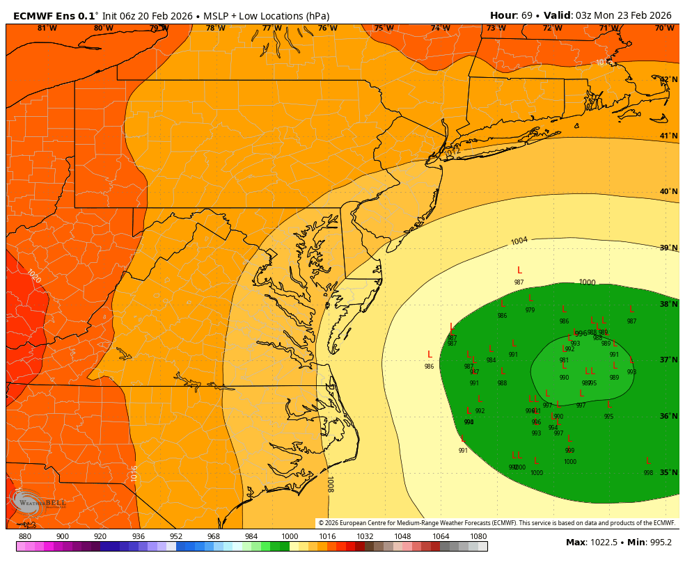
Good heavens, the 3k NAM has the low down to 965 at the end of its run at 7 am on Monday. -
Central PA Winter 25/26 Discussion and Obs
Blizzard of 93 replied to MAG5035's topic in Upstate New York/Pennsylvania
Even if the NAM verified, I don’t think many of us would be too upset with a widespread 8 to 12 in the LSV. -
Central PA Winter 25/26 Discussion and Obs
Blizzard of 93 replied to MAG5035's topic in Upstate New York/Pennsylvania
There is also usually a secondary jackpot outside of the main area depending on where the best bands set up. A low that’s deepening to that level will push some heavy bands well inland. -
Central PA Winter 25/26 Discussion and Obs
Blizzard of 93 replied to MAG5035's topic in Upstate New York/Pennsylvania
Still some wrap around ongoing early Monday afternoon! -
Central PA Winter 25/26 Discussion and Obs
Blizzard of 93 replied to MAG5035's topic in Upstate New York/Pennsylvania
Long duration… Starts Sunday am & just ramps up & continues through overnight into early Monday. Bring it! -
Central PA Winter 25/26 Discussion and Obs
Blizzard of 93 replied to MAG5035's topic in Upstate New York/Pennsylvania
Hopefully we reel this one in! I was just having fun with my last post to you & Canderson. We all have our posting tendencies & that is what makes this place great. I am still in a little disbelief that the GFS lead the way on this one so far and has not wavered much for a few days. I will be happy with a widespread 6 inches of snow with some lucky spots hitting double digits. Let’s see where the final trends take us this weekend up until game time. -
Central PA Winter 25/26 Discussion and Obs
Blizzard of 93 replied to MAG5035's topic in Upstate New York/Pennsylvania
I think it a fantastic sign with the last round of posts this evening… @canderson lowballing Harrisburg amounts & showing an incorrect Harrisburg forecast by CTP… Check! @Itstrainingtime time getting nervous & full of trepidation… Check! I say these things with love as long time posters… to me, it means it’s go time around here for a Winter Storm! -
Central PA Winter 25/26 Discussion and Obs
Blizzard of 93 replied to MAG5035's topic in Upstate New York/Pennsylvania
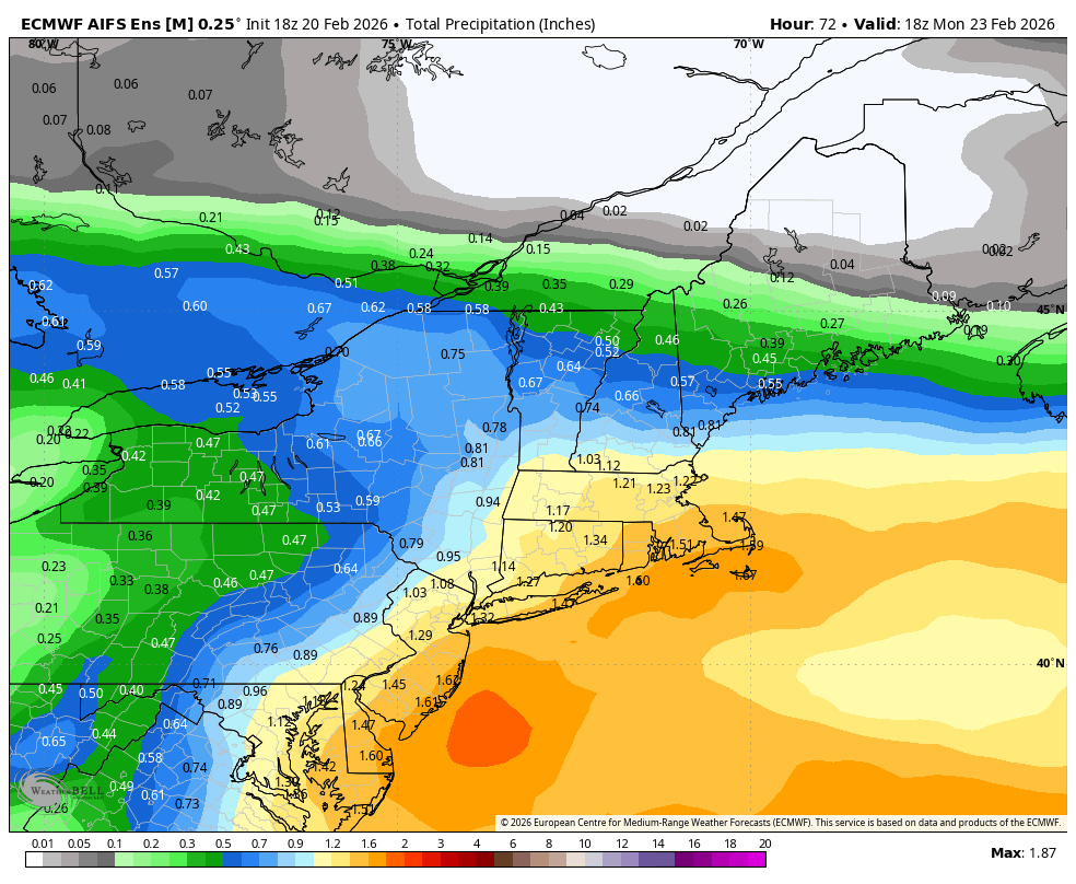
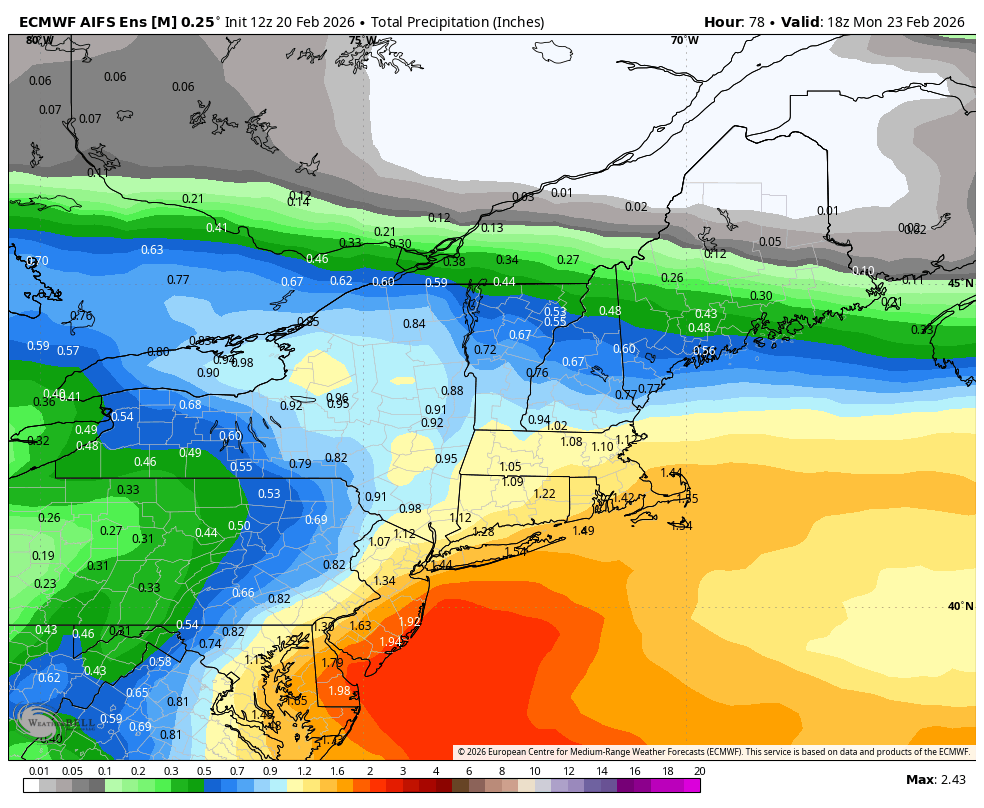
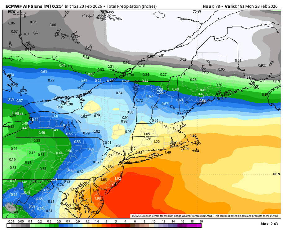
Good uptick on precip on the 18z AI EPS as well.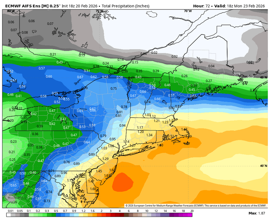
-
Central PA Winter 25/26 Discussion and Obs
Blizzard of 93 replied to MAG5035's topic in Upstate New York/Pennsylvania
Don’t you dare bring up Boxing Day on here sir, lol! That storm took a convoluted track that went out & then up, putting the LSV on the edge. That storm was forecast Well out to sea & then crept back to life on Christmas Eve, but the LSV was on the fringe & it failed back here. That was a totally different scenario in my opinion. -
Central PA Winter 25/26 Discussion and Obs
Blizzard of 93 replied to MAG5035's topic in Upstate New York/Pennsylvania
Nope, nice try, lol! They just haven’t updated their grids. Winter Storm Watch includes Harrisburg… Winter Storm Watch URGENT - WINTER WEATHER MESSAGE National Weather Service State College PA 140 PM EST Fri Feb 20 2026 PAZ057>059-064>066-211145- /O.NEW.KCTP.WS.A.0004.260222T1000Z-260223T1800Z/ Dauphin-Schuylkill-Lebanon-Adams-York-Lancaster- Including the cities of Pottsville, Hershey, Harrisburg, York, Lancaster, Lebanon, and Gettysburg 140 PM EST Fri Feb 20 2026 ...WINTER STORM WATCH IN EFFECT FROM LATE SATURDAY NIGHT THROUGH MONDAY AFTERNOON... * WHAT...Heavy snow possible. Total snow accumulations between 4 and 6 inches possible. * WHERE...A portion of central Pennsylvania. * WHEN...From late Saturday night through Monday afternoon. * IMPACTS...Travel could be very difficult. The hazardous conditions could impact the Monday morning commute. * ADDITIONAL DETAILS...There is still some uncertainty regarding the track of this storm. Any westward shifts in the track may result in higher snowfall amounts. -
Central PA Winter 25/26 Discussion and Obs
Blizzard of 93 replied to MAG5035's topic in Upstate New York/Pennsylvania
I just got a closer look at the 18z EPS and am really happy to see how many tucked ensemble members are showing this run. Total precip still looks good. -
Central PA Winter 25/26 Discussion and Obs
Blizzard of 93 replied to MAG5035's topic in Upstate New York/Pennsylvania
If the storm tracks as close to the coast as the GFS depicts, banding will extend WELL back inland beyond what is currently being shown. The LSV is in a good spot. -
Central PA Winter 25/26 Discussion and Obs
Blizzard of 93 replied to MAG5035's topic in Upstate New York/Pennsylvania
Wow! Let’s gooooooooo !!!! -
Central PA Winter 25/26 Discussion and Obs
Blizzard of 93 replied to MAG5035's topic in Upstate New York/Pennsylvania
Another fascinating day of tracking ! -
Central PA Winter 25/26 Discussion and Obs
Blizzard of 93 replied to MAG5035's topic in Upstate New York/Pennsylvania
6z EPS is decent, with several west leaning ensemble members that could provide upside snow potential. The mean still brings 4 inches to the LSV this run.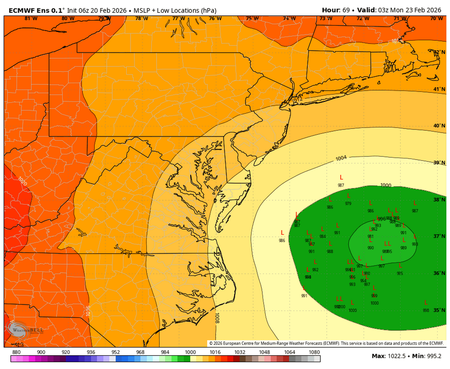
-
Central PA Winter 25/26 Discussion and Obs
Blizzard of 93 replied to MAG5035's topic in Upstate New York/Pennsylvania
6z GEFS is very impressive for this range. Lots of west leaning ensemble members. -
Central PA Winter 25/26 Discussion and Obs
Blizzard of 93 replied to MAG5035's topic in Upstate New York/Pennsylvania
6z Euro still brings most of its snow to us from the inverted trough. It still has Warning level snow for the LSV this run. -
Central PA Winter 25/26 Discussion and Obs
Blizzard of 93 replied to MAG5035's topic in Upstate New York/Pennsylvania
6z GFS shows another tucked low just off of OCMD, bringing heavy snow potential to the LSV again this run.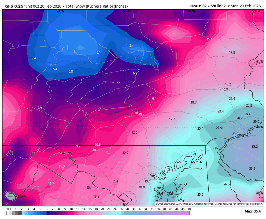
-
Central PA Winter 25/26 Discussion and Obs
Blizzard of 93 replied to MAG5035's topic in Upstate New York/Pennsylvania
Absolutely too early to call this one. Wide model discrepancy especially between the GFS & Euro. -
Central PA Winter 25/26 Discussion and Obs
Blizzard of 93 replied to MAG5035's topic in Upstate New York/Pennsylvania
0z GEFS snow