

Maxwell03
-
Posts
266 -
Joined
-
Last visited
Content Type
Profiles
Blogs
Forums
American Weather
Media Demo
Store
Gallery
Everything posted by Maxwell03
-
I've been noticing a trend in southern NJ going back to January with a few pieces to it: 1) there is a persistent haze that rests over the horizon on sunny days, (2) light pollution turns the night sky a nautical almost twilight-esque blue color during clear conditions regardless of moon phase, and (3) the sky blackens like a summer thunderstorm on pretty much every afternoon that it rains. Is this the work of a temperature inversion? Dust in the atmosphere? Something else? I was wondering if anyone on the NY forum had noticed these phenomena. I've brought it to the attention of other folks with a mixed response, and I'd like to nail down the culprit.
-

E PA/NJ/DE Winter 2022-2023 OBS Thread
Maxwell03 replied to Ralph Wiggum's topic in Philadelphia Region
It is…positively lovely outside -
E PA/NJ/DE Winter 2022-2023 OBS Thread
Maxwell03 replied to Ralph Wiggum's topic in Philadelphia Region
Been hazy for a while, but today might be the biggest aggressor so far. What’s with the eternal inversion lately? -
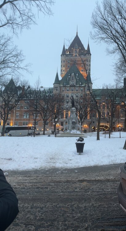
Spent the weekend in Quebec, thought you guys might enjoy a refresher of what winter looks like:
-
E PA/NJ/DE Winter 2022-2023 OBS Thread
Maxwell03 replied to Ralph Wiggum's topic in Philadelphia Region
Yeah so, am I truly the only one noticing/weirded out by this persistent sky glow/inversion/trapped light pollution pattern of recent weeks? Can anyone else back me up here? I keep consulting people in knowledgeable circles and people just ask me to get my health checked out. I’m not crazy and I do think I’m noticing an anomaly. In fact I think it had a big role in amplifying our fog today. -
No bolts but several loud bangs with mixed hail* and rain at my house. Great stuff 0.72” in the gauge this morning.
-
E PA/NJ/DE Winter 2022-2023 OBS Thread
Maxwell03 replied to Ralph Wiggum's topic in Philadelphia Region
Am I crazy or has the late night sky registered as a brighter, bluer color recently? Almost an early twilight color? Maybe there's a simple explanation like an inversion or maybe it's a natural hue of the night sky but my brain keeps interpreting it as unfamiliar. -
Not unusual for a cold season warm-up preceding a frontal passage. It is unusual to throw a tropical system into the mix.
- 852 replies
-
- 1
-

-
- hurricane
- tropical storm
- (and 1 more)
-
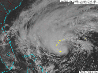
Yeah agreed, it doesn’t look half bad for a TC in November.
-
0.44" from last night's storms, un-sarcastically a ton of fun driving in them. Now here comes the cold.
-
I'm convinced this storm doesn't run out of moisture
- 852 replies
-
- 1
-
-
- hurricane
- tropical storm
- (and 1 more)
-
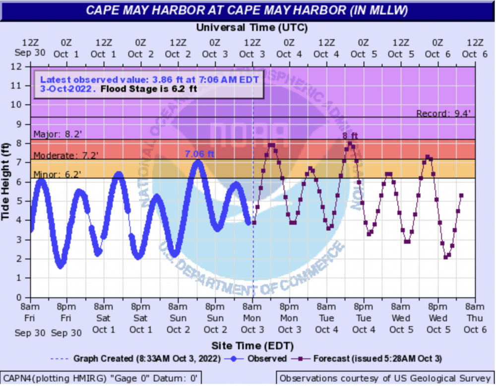
More heavy rain headed for Ocean County -- just in time for the 2:30 high tide.
- 852 replies
-
- 2
-
-
- hurricane
- tropical storm
- (and 1 more)
-
Persistent onshore flow is no joke. I think water may approach our house in Wildwood on Tuesday, which to my knowledge has only flooded in big events.
-
This storm delivered some of the most jarring footage in years. Reporters and lay persons always come off prone to hyperbole in these situations but there is no embellishing what we saw today. This was the real deal.
-
The way it just seamlessly passes over Cuba as if it's not even there
-
Yeah it is very delicate given the night and day difference from small deviations in tracks. A mildly aggressive approach seems the most prudent? Post evacuation orders for the most vulnerable? Always better safe than sorry.
-
It does look very Sandy-esque on satellite
-
The I storm curse, yeah I know. I just really disliked the name Hermine.
-
Yes, I knew that. I don’t know if they’ve used the watches/warnings for Labrador yet though.
-
I knew operationally there were watch/warning breakpoints on the Labrador coast, but I never expected to see them actually used.
-
2022 Atlantic Hurricane season
Maxwell03 replied to StormchaserChuck!'s topic in Tropical Headquarters
This rotten spinner in the subtropical Atlantic is going to steal the name Gaston and we're gonna have to deal with a land bound storm named .... Hermine -
Yeah it emerged practically unscathed and ready to blow. I thought there would be a bigger hiccup in intensity. An ominous look to it this afternoon.
-
2022 Atlantic hurricane season whining/banter
Maxwell03 replied to GaWx's topic in Tropical Headquarters
Bro get help


