

The 4 Seasons
-
Posts
7,999 -
Joined
-
Last visited
Content Type
Profiles
Blogs
Forums
American Weather
Media Demo
Store
Gallery
Everything posted by The 4 Seasons
-
I mean he did and the context is 171HR frame of the Icon. I'm just wondering what the hell that came from, im guessing it was fed into AI and it spit back out something that looks cooler based on the prompt
-
what exactly am i looking at here?
-
Wednesday Feb 18 Mixed event. NOPE …ain’t happenin’
The 4 Seasons replied to HoarfrostHubb's topic in New England
tell me about it, this is lights out here for sure but still have interest in Fri but thats probably nothing as well other than some mixed slop -
Presidents' day Snow potential
The 4 Seasons replied to WeatherGeek2025's topic in New York City Metro
Curious where you get these before the CLI comes out? OKX never plotted them on the interactive map -
interesting never heard that before. Yeah, white rain is a common term on here. It's the worst.
-
lol you never heard that term before? i know you've had to. Snow that falls but doesnt accumulate, might as well be rain. hence, white rain.
-
and if you dont, you can still get white rain in Dec/Jan with a very low sun angle just because temps/rates were not good. Jan 2006 i was in the mid 30s with not great rates but it snowed all day and accumulated like a 1:1 inch of pure clear slush. Crazy elevation event here in CT. Some reports within the same town varied from 1-12"
-
Thats helpful, i can add the 28" in Paxton and 27" in Rutland. If there's anything else you have that would be helpful or anything else i should remove/add here. Yeah 30" in Winchendon, 28" Gardner 18.3 Ashburnham COOP, Barre Falls 16.9"
-
he needs it
-
The depth in S. VT in mid march was ungodly. I remember as a kid jumping off of the roof into the backyard cuz the snow was so deep.
-
What i would pay for that Icon soln, god damn. Can we just get a classic nor'easter once this season? I mean idc how it snows, but a blizz would be nice. changing the clocks ahead also increases afternoon warming...
-
I'm putting them at 22.1 since they reported 0.1 on the 7th. You can see it on the radar that they had some light snow pull through just after midnight. I'm going to be aggressive with the 20" line since a lot of these reports end Tue evening/night and trying to toss anything from Tue morning. If i only included the ones that are "final" on the PNS there would hardly be anything. And OKX doesnt even list the times so that makes it even worse. BDL is also definitely wrong at 9.9" all the surrounding reports are around 12-14"
-
that lines up well. N Foster 8.3 and Kent 6
-
N. Foster had 16.1 so that seems close enough, West Thompson Lake 16". So many of these reports on the PNS are ending at Tuesday morning so they are completely invalid and too low, had to delete a lot which sucks
-
I'm never touching March 4-6, 2001 again. what a nightmare with these PNS
-
i see i thought you were making a joke about combining the "EE" rule and "weekend" rule. But i have noticed a ton of big storms occurred on weekends Anyway, can you see my last post on new England snowstorm memories, if you have Mar 4-6, 2001 and Dec 30th, 2000, that would be helpful
-
thrilling stuff i had 0.15 but rounded down to 0.1 in anger
-
a joke.
-
really? I remember reading something in the early/mid 2000s that nearly all of the major all-snow blizzards/snowstorms occur on or around the weekend. I always remembered that growing up, not that it matters or makes a difference in anything.
-
@Ginx snewx would you happen to have March 4-6, 2001 as well?
-
If anyone has S/SW CT totals from this let me know
-
BTW the 00Z UKMET also had a hit for that 23rd system at the end of the run.
-
6Z Euro came in colder for the Fri/Sat threat.
-
Presidents' day Snow potential
The 4 Seasons replied to WeatherGeek2025's topic in New York City Metro
doubtful -
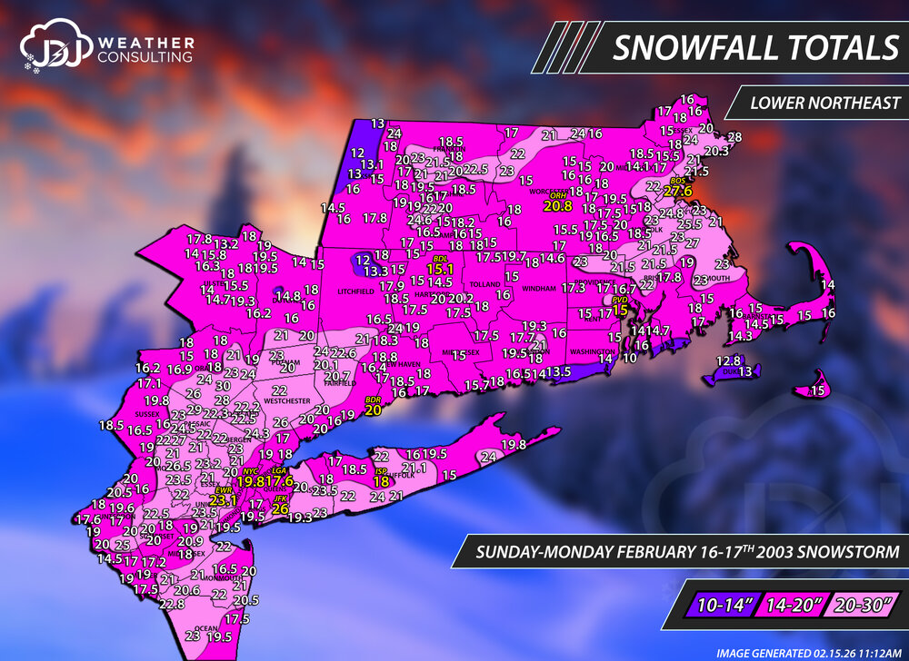
Today (and tomorrow) is the 23rd anniversary of PDII. For that i have refreshed the maps for the event and created a new L Northeast map as well. It is Bostons #1 all time storm and BDRs #2 all time and only the 2nd time ever they reached 20" or more. 15-28" at every single climate site in OKX and BOX is impressive. Full radar/sfc loops up here: https://www.jdjweatherconsulting.com/feb-16-17-2003 UPDATED for Plymouth County.