

thunderbolt
-
Posts
821 -
Joined
-
Last visited
Content Type
Profiles
Blogs
Forums
American Weather
Media Demo
Store
Gallery
Posts posted by thunderbolt
-
-
51 minutes ago, raindancewx said:
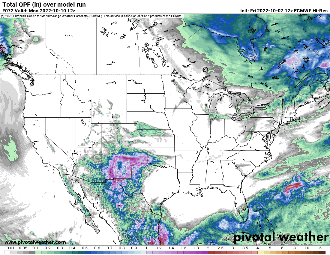
Not a bad call on my end from June - I'm sure everyone else expected near record early October rains in the Southwest in a La Nina right? Especially with a lot more coming still?

I've been very busy lately, but I did upload my winter forecast today if anyone is curious.
Let me guess I don’t even have to read it you’re predicting a less snowy year for the northeast and less cold
-
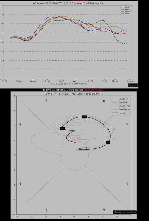
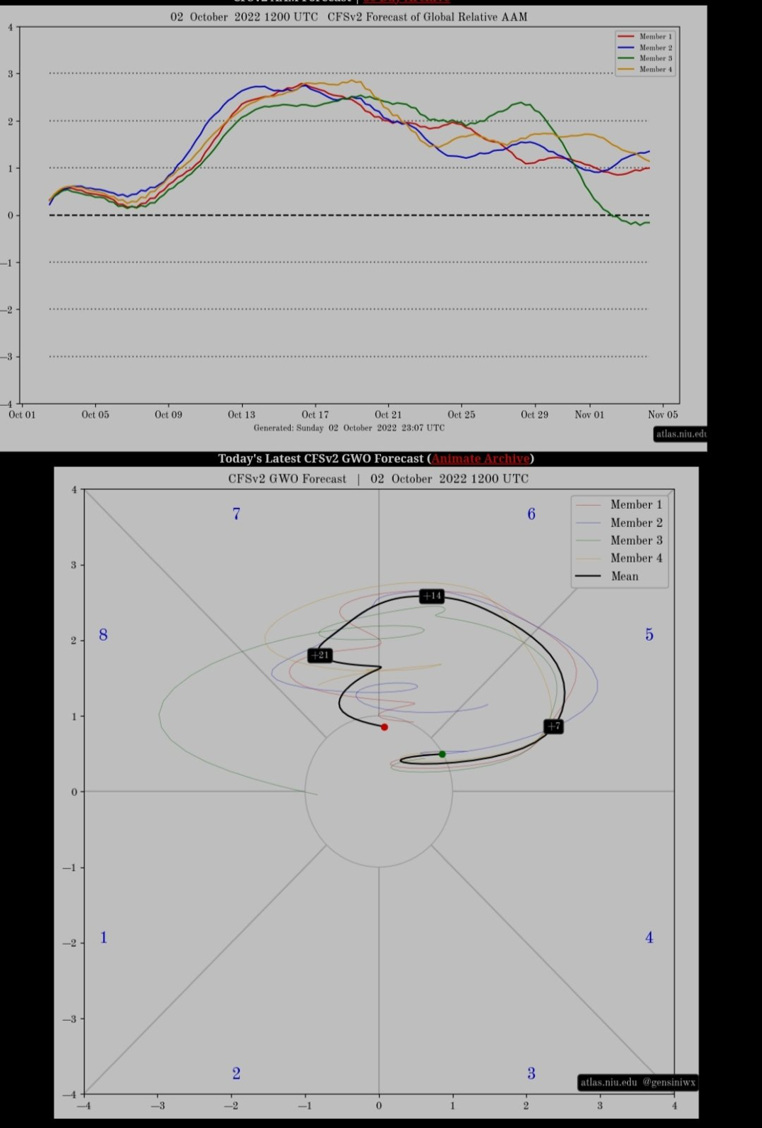
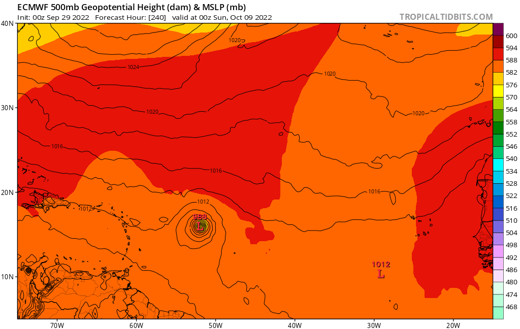
Almost like EL Nino sharp rise in AAM. Anybody Has access to GWO phase 6-7 composites Oct/Nov? Per Julius S tweet
-
Maybe another one

-
 1
1
-
-
Another perspective

-
24 minutes ago, Amped said:
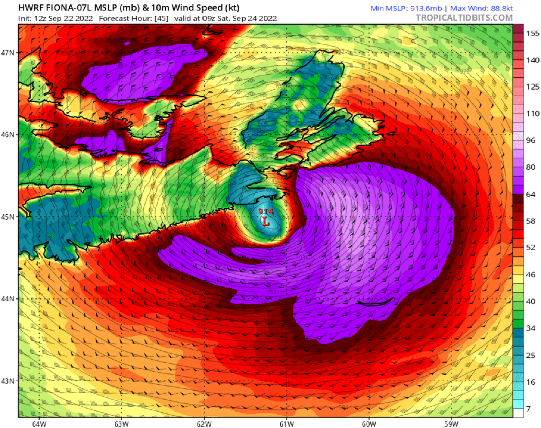
Extrap down to 942 SFMR around 107kt, that's on the NW side of the eye.
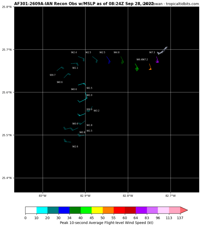 939 mb
-
1
-
-
1 hour ago, yoda said:
Hmmm... weakens 15 to 20mb from 168 to 174
Quite a few of the models have been doing that lately something to really consider in the future
-
Just now, thunderbolt said:
Just your typical 914 mb hurricane up in Canada

 Next will be Seeing 2 feet of snow in Miami
-
Just your typical 914 mb hurricane up in Canada
-
1
-
 1
1
-
-
9 minutes ago, WxSynopsisDavid said:
4mb drop since 11pm and its not even midnight yet. Appears the pressure has finally caught up to the winds. Bombs Away!!!!!
https://m.imdb.com/title/tt0088838/mediaviewer/rm479957504/?ref_=tt_ov_i
-
Does anybody know the rain totals coming out of Puerto Rico
-
Stage right
-
I guess everybody will look at La Niña’s a little bit different in the future it’s not a slam dunk like it used to be Obviously there’s other pieces of puzzles that trump la Niña
-
11 minutes ago, bluewave said:
We have been able to avoid any major 95°+ heat this month due to the record south based blocking. This has allowed all the record heat to remain in the Western US. So only one day in the low 90s this month so far at Newark.

Hey blue what do you mean by South base blocking?
-
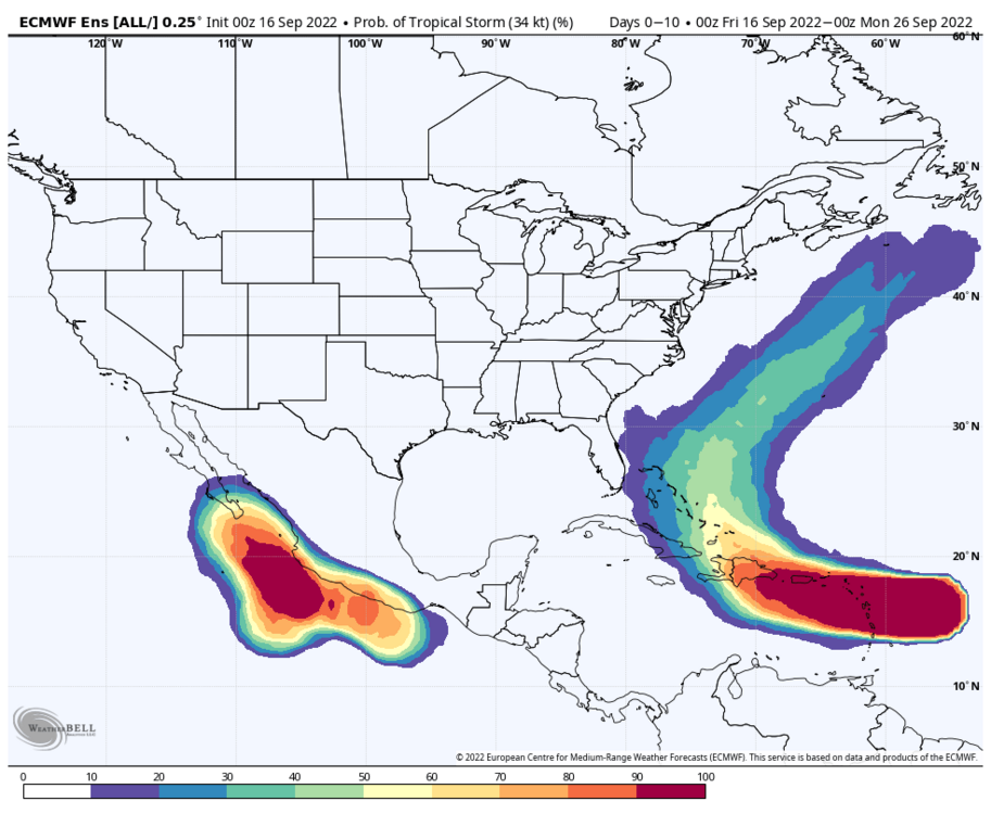
12 minutes ago, GaWx said:
For the same AEW, the 0Z GEFS is by far the most active run yet with more than half the 31 members with hurricanes. About half of those recurve harmlessly, but the others threaten at least the Caribbean 9/15-17+ fwiw.
Your model analysis is awesome Keep them coming
-
3
-
 1
1
-
-
1 hour ago, bluewave said:
Some good news for the holiday weekend outdoor activities is that the Euro and RGEM are really slowing the front down due to the stronger WAR. So we could see mostly dry conditions into Labor Day. This means that the warm spots with less clouds could tack on another 90° day. It is going to take a very strong -NAO to bring temps back closer to normal for several days following Labor Day. Then upper 80s to around 90° could return next weekend as the blocking relaxes. As usual, the models haven’t been stellar with the rainfall forecasts recently. So we’ll take whatever we can get.


Can you please post that NAO graph in the middle of January please
-
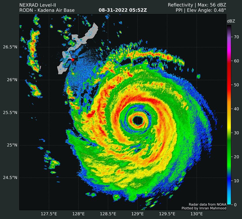
Go big or go home in Western Pacific
-
1
-
-
1 hour ago, snowman19 said:
I don’t follow his logic, if it caused the stratosphere to cool during winter in the Southern Hemisphere, why would it cause the stratosphere in the northern hemisphere to warm? The stratosphere is the stratosphere and water vapor in the stratosphere has been scientifically proven to cool it, doesn’t matter if it’s south of north of the equator. Water vapor from the eruption has already infiltrated the northern hemisphere. He’s also talking about SSWEs, I was honestly confused by that article. Is the author a meteorologist?
I know I just thought the article was kind of interesting myself I guess will revisit this in March of next year to see if it came to fruition or not
-
On 8/27/2022 at 6:10 PM, 40/70 Benchmark said:
Most of his posts are are like black and white diagrams of the tropics with a bunch of arrows and mention of the word "flux" no less than four times.
https://t.co/gK3tCuYBYo Very interesting article about the stratosphere in the south pole with the volcano irruption that took place And how it could possibly affect the NAO in the northern hemisphere
-
1
-
1
-
-
44 minutes ago, Amped said:
The happy hour GFS was a good laugh between the fake storm in the western gulf and the circle back track into NC/SC.
Yep and then comes up our way and gives us a drought buster like you said you need a good laugh
-
1
-
-
3 minutes ago, GaWx said:
Third year La Niña/cold neutral seasons have had a tendency to be quite a bit weaker than their respective prior seasons and many other La Niña seasons.
How many third year Cold neutral years were there?
-
1 minute ago, Floydbuster said:
I see no reason why we've been so inactive.
We have a La Nina, we have strong waves leaving Africa. The only possible thing I think could be the Saharan Air but that is a factor every season. Even 2005 had a huge amount of dust in the Summer during that hurricane season.
I do recall seasons like 1998, 1999 and 2000, which have been seen as analogs to some this year, where the season really took off in September.

Yeah you would think it’s an El Niño year The way things have been going winds Sheer is really doing damage to any storm that try to get going
-
Just now, Floydbuster said:
Well, I will fall on my sword. I said we'd have a major hurricane by August 28th. We will not.
That being said, I am kinda surprised why the GFS isn't more enthusiastic about Invest 91L.
It’s GFS enough said
-
1
-
-
5 minutes ago, GaWx said:
There's no credibility to lose. There hasn't been any in 20+ years of posting going back to Isabel and before. That being said, ldub is looking incredibly lucky for August and it would be funny if the weak season call ends up right despite no credible scientific reasoning backing the prediction. There was one weak year that the same person won in a season contest I ran naturally due to eternal bearishness.
On a related note, keep in mind that a TD that forms in August that then becomes a TS in Sept. is counted by some including me as an August, not Sept., storm due to going by month of TC genesis.
Not me I go by when it’s giving its name then it’s official
-
1
-
-
5 minutes ago, hawkeye_wx said:
Boy, the western Atlantic ridge to the north of the storm vanishes in a flash at the end of the run. What initially looks like a free run to the coast turns into a northeastward escape.
It was like It hit a brick wall Fishy fishy fishy


Winter 2022-2023 Conjecture
in New England
Posted
Just curious what is your opinion on How winter is going to turn out