

thunderbolt
-
Posts
821 -
Joined
-
Last visited
Content Type
Profiles
Blogs
Forums
American Weather
Media Demo
Store
Gallery
Posts posted by thunderbolt
-
-
1 hour ago, snowman19 said:
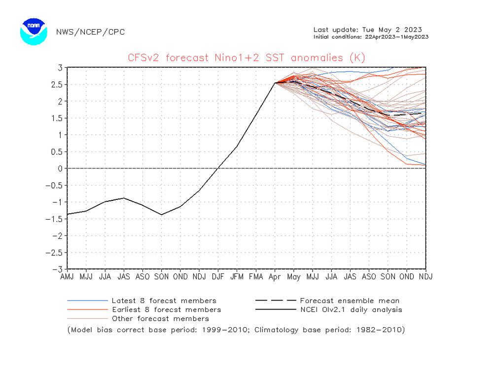
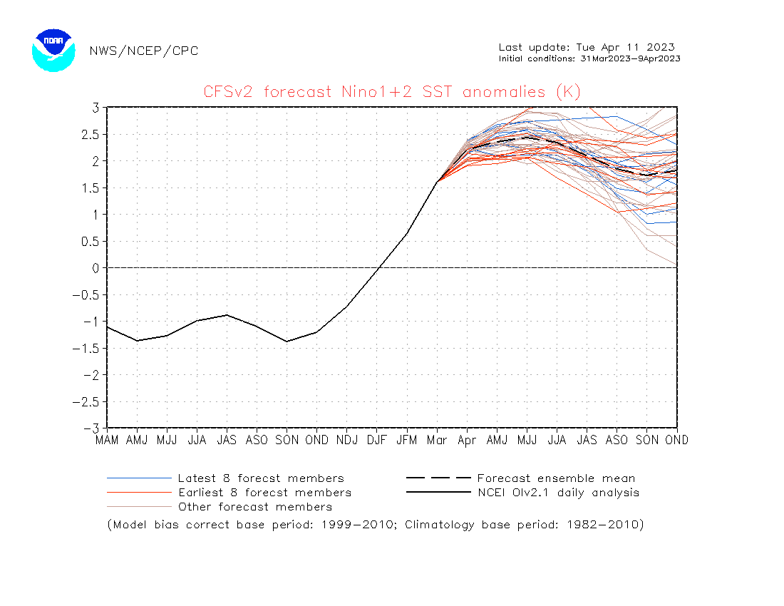
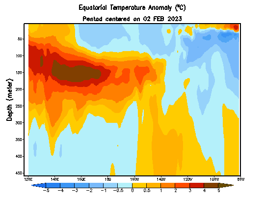
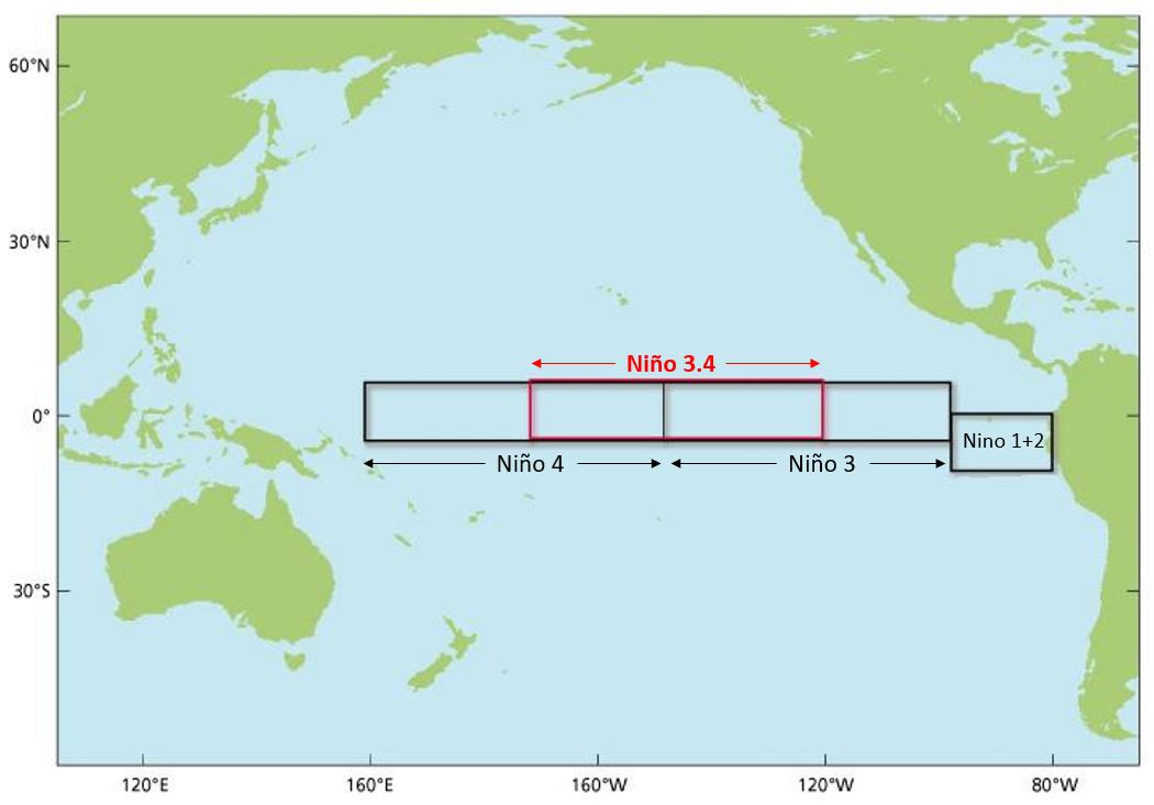
So much for region 1+2 dropping. It appears Bjerknes feedback is setting up, if that’s what’s happening it’s going to sustain that warmth and continue to migrate into region 3. Studies have shown Bjerknes feedback is enhanced when it sets up over the eastern ENSO regions. See this study https://www.tropicaltidbits.com/analysis/ocean/nino12.png https://www.nature.com/articles/s41467-022-33930-5#:~:text=El%20Niño%2DSouthern%20Oscillation%20
-
 1
1
-
-
3 hours ago, bluewave said:
Yeah, pretty far west for a developing El Niño this time of year. So the subsurface below Nino 3.4 is much less impressive than the super years like 97-98 and 15-16. But Nino 1+2 is near record levels for April. Sustained Nino 1+2 values above +2 usually are accompanied by more warming in 3.4 than we have currently seen. So no analogs at all for this type of El Niño evolution both in regard to the WWB activity and faster 1+2 warming. Tough to guess how this will ultimately end up in terms of strength and location of warmest anomalies.


Well said Blue at this point it’s just a guessing game how everything is going to turn out and how the atmosphere is going to react to everything
-
2
-
-
2 hours ago, bluewave said:
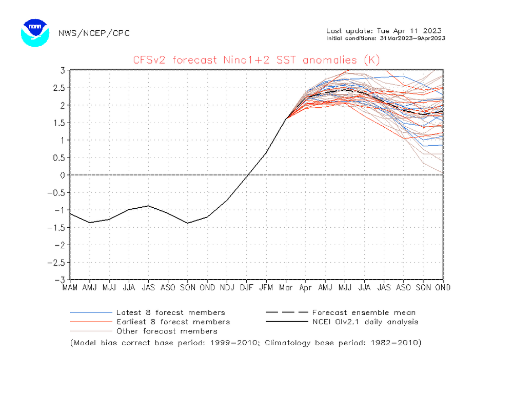
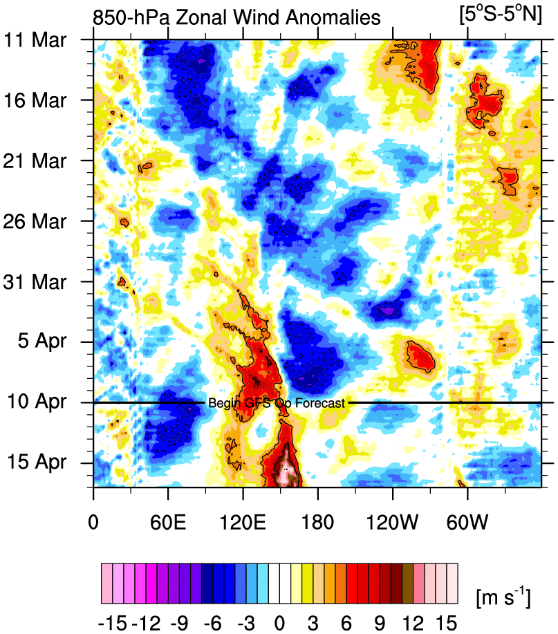
It’s on the World Climate Service site. I like looking at the dailies so we can get an idea what the monthly will look like before it’s released. This current WWB is pretty moderate by April El Niño standards. So the subsurface warming and Nino 1+2 may have peaked for the current time. Would need a stronger and more sustained WWB later on for Nino 3.4 to go from neutral to weak El Niño above +0.5. A strong -PDO and very warm WPAC can keep the trades going and weaken WWB potential. We have seen this numerous times since 2012. The only spring the trades fully relaxed was back in 2015 which a very warm PDO and subsurface. Can’t really use -PDO analogs before recent years since the WPAC has warmed so much. Notice how much warmer the WPAC is now from 1972 along with the cooler tongue from California to the CPAC. So the WWBs are much weaker now. Need the -PDO to relax a bit in coming months to have a shot at a strong El Niño event.
https://s2s.worldclimateservice.com/climatepanel/


Thanks brother
-
1 hour ago, bluewave said:
May be a struggle to get a really strong and sustained WWB while the daily PDO dropped again in the last few weeks.

Yo Blue where can I find this link for the PDO
-
8 minutes ago, snowman19 said:
Strong as of nowDefinition of strong
-
To me this looks like a basin wide
-
1
-
-
 This is going to help
-
28 minutes ago, bluewave said:
Wonder if Nino 1.2 peaks early in the next few months like 57-58 did? These Nino 1+2 maxes typically occur later on in the event. Then there is the possibility of a secondary peak a few months after that like we saw with 97-98 and 82-83.
-
-
That should help out Regions 4 and 3.4

-
 1
1
-
-
1 hour ago, snowman19 said:
A very significant El Niño for 23-24 is gaining more and more traction. The fact that we are in 3rd place right now behind only 82-83 and 97-98 is very telling, the big dogs developed as eastern Pacific Ninos like this one is so farI think the question at hand is what is going to be the strength
-
-
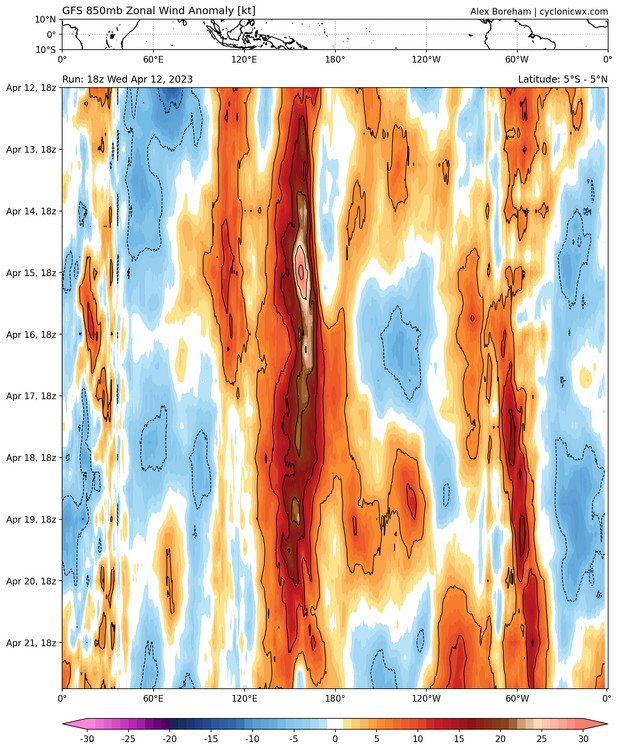
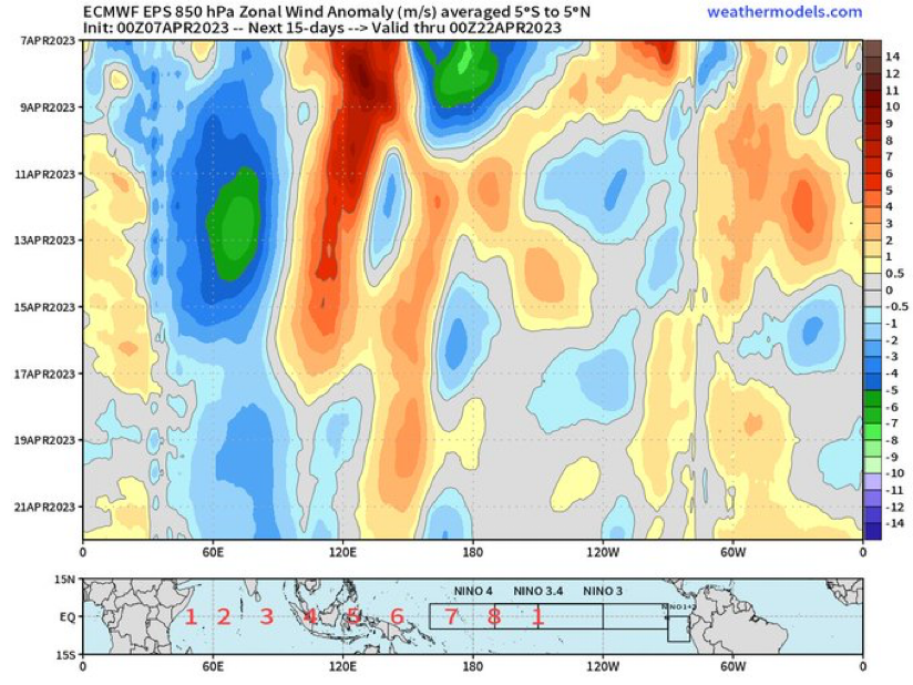
As we head into mid April, the EC ensemble is predicting another period of basin-wide trade wind reduction across the Equatorial Pacific. It's not a massive WWB, but this will probably be another nudge of the coupled atmosphere/ocean state towards El Niño as the year goes on.
-
Just now, thunderbolt said:
What is the Definition of East based
Does region 1/2 have to be .5 stronger then region 3.4 And I always thought region 1.2 is more volatile than any of the regions always up and down
-
11 hours ago, snowman19 said:
We haven’t seen a true east-based El Niño in 25 years. Every Nino since then has been Modoki/western tilt/basin-wide. Eventually it’s going to happen again, east-based events tend to be more common in -PDO regimesWhat is the Definition of East based
-
57 minutes ago, Violentweatherfan said:
What was really surprising was geographically within a few miles how dark it was. Like night and day.
Literally
Sounds like new town and part of Falls Township got hit pretty good At least according to the fire scanner
-
1
-
-
-
-
-
-
9 hours ago, George001 said:
That’s possible, but a lot of that warmth is already starting to surface. It could be wrong yeah but you don’t often see the models projecting a near +3 super nino. It may not be THAT strong, but i do think this is different than the 2012 head fake. The combination of model projections, us coming off a 3 year Nina, the MJO wave earlier in March, and the amount of warmth building in the enso 1.2 and 3 regions makes me think this El Niño is for real.
The BOM Model is notorious for being too aggressive case and point last year at this time
-
1
-
-
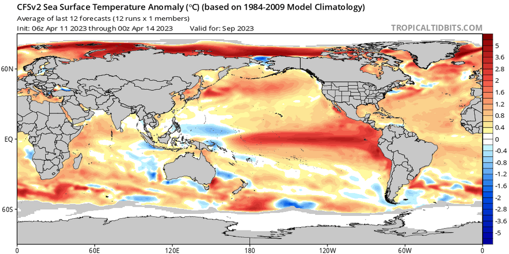
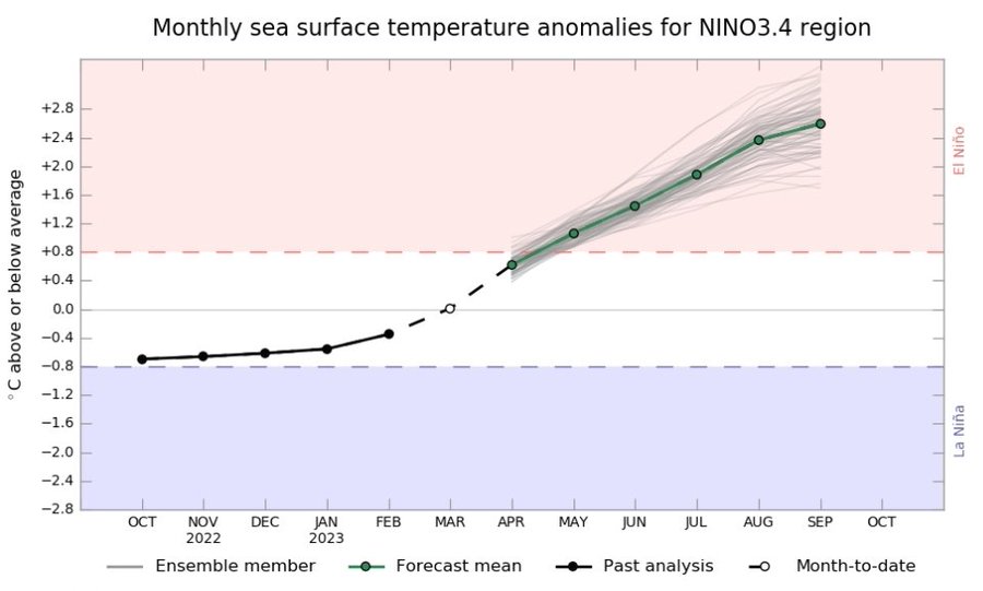
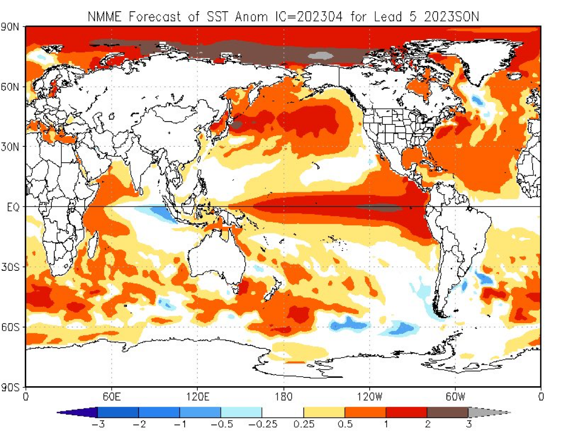
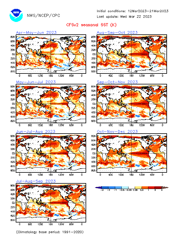
At least according to this graph this appears to be a basin wide El Niño by November Like everybody else says it’s just wait and see will definitely have a better answer by June or July in my opinion to see where this is possibly going

-
2
-
-
1 minute ago, thunderbolt said:
El Niño - 26 La Niña - 25 Weak - 11 Moderate - 7 Strong - 5 Very Strong - 3 Weak - 11 Moderate - 6 Strong - 7 1952-53 1951-52 1957-58 1982-83 1954-55 1955-56 1973-74 1953-54 1963-64 1965-66 1997-98 1964-65 1970-71 1975-76 1958-59 1968-69 1972-73 2015-16 1971-72 1995-96 1988-89 1969-70 1986-87 1987-88 1974-75 2011-12 1998-99 1976-77 1994-95 1991-92 1983-84 2020-21 1999-00 1977-78 2002-03 1984-85 2021-22 2007-08 1979-80 2009-10 2000-01 2010-11 2004-05 2005-06 2006-07 2008-09 2014-15 2016-17 2018-19 2017-18 2022-23 
The Oceanic Niño Index (ONI) has become the de-facto standard that NOAA uses for classifying El Niño (warm) and La Niña (cool) events in the eastern tropical Pacific. It is the running 3-month mean SST anomaly for the Niño 3.4 region (i.e., 5oN-5oS, 120o-170oW). Events are defined as 5 consecutive overlapping 3-month periods at or above the +0.5o anomaly for warm (El Niño) events and at or below the -0.5 anomaly for cool (La Niña) events. The threshold is further broken down into Weak (with a 0.5 to 0.9 SST anomaly), Moderate (1.0 to 1.4), Strong (1.5 to 1.9) and Very Strong (≥ 2.0) events. For the purpose of this report for an event to be categorized as weak, moderate, strong or very strong it must have equaled or exceeded the threshold for at least 3 consecutive overlapping 3-month periods. -
1
-
2
-
-
12 hours ago, Terpeast said:
What is considered to be the line between a strong vs super? +2.5?
El Niño - 26 La Niña - 25 Weak - 11 Moderate - 7 Strong - 5 Very Strong - 3 Weak - 11 Moderate - 6 Strong - 7 1952-53 1951-52 1957-58 1982-83 1954-55 1955-56 1973-74 1953-54 1963-64 1965-66 1997-98 1964-65 1970-71 1975-76 1958-59 1968-69 1972-73 2015-16 1971-72 1995-96 1988-89 1969-70 1986-87 1987-88 1974-75 2011-12 1998-99 1976-77 1994-95 1991-92 1983-84 2020-21 1999-00 1977-78 2002-03 1984-85 2021-22 2007-08 1979-80 2009-10 2000-01 2010-11 2004-05 2005-06 2006-07 2008-09 2014-15 2016-17 2018-19 2017-18 2022-23 -
3
-


El Nino 2023-2024
in Weather Forecasting and Discussion
Posted
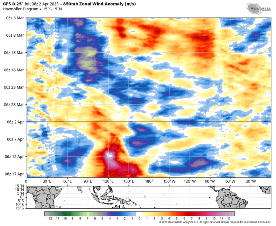
Looks like it leveled off