

thunderbolt
-
Posts
821 -
Joined
-
Last visited
Content Type
Profiles
Blogs
Forums
American Weather
Media Demo
Store
Gallery
Posts posted by thunderbolt
-
-
3 minutes ago, bluewave said:
Texas is one of the warmest parts of the country this month. DFW is having a top 10 warmest June. So it makes sense with a very strong ridge in the Plains. But the near record block just north of Hudson Bay typically doesn’t go with this type of pattern. So this is why the 100° heat near the Great Lakes has stayed to our west which is unusual.
Much stronger blocking this June for DFW top 10 warmest composite
2022 vs composite


Yo blue what year would be a good comparison to this year’s specifically June? Specially with the blocking up north and the strong ridge in the middle of the country
-
42 minutes ago, Weather Will said:
WB 18Z GFS continues the pattern through the end of the month. What a June….


Okay I’ll say it where was this pattern in January and February
-
 1
1
-
-
21 minutes ago, SnoSki14 said:
Wow at the Nam with regards to the MCS
For this evening I’m assuming
-
 1
1
-
-
5 hours ago, bluewave said:
Latest extended forecasts maintain the comfortable June temperature pattern for us. Near record heat heads for the Great Lakes next week. But we stay cooler with more onshore flow. One of the first times in mid-June that temperatures well into the 90s near the Great Lakes didn’t progress into our area. So an unusual 500 mb and surface pattern for us. The ridge is still forecast to remain to our west even as we pass the solstice. So while we can always pick up a stray 90° at places like Newark, no major 95°+ heat like we had in late May anytime soon.


That’s really help out with my electric bill
-
3
-
-
On 5/28/2022 at 12:24 PM, StormchaserChuck! said:
Not every week is going to act like La Niña
-
-
7 hours ago, Wxoutlooksblog said:
Sometime between June 14th-18th it's looking as though it's going to get to be at least quite warm, maybe hot. But it appears there'll be a very active ROF at the leading of this hot air mass and any kind of wave of low pressure development or stronger upper air disturbance moving over and down around the big ridge can delay the eastward progression of the heat ridge.
WX/PT

ROF?
-
1 hour ago, nycwinter said:
i see a lot of comments about how they are sick of this kind of weather. again i ask why would anyone want warm and humid weather from now until late september? i prefer to keep the heat away for as long as possible no sane person would want humid hot weather for 6 months non stop if that is the kind of weather you like.. move to florida!!!
I’m not saying that I want 90s and dew points in the 70s but just give me a few days in the low 80s and low humidity And Sunny of course
-
15 minutes ago, forkyfork said:
i just want it to be hot. why can't it be 97 degrees right now?

I hear you brother and if I may add a few good thunderstorms in there
-
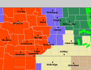
North Dakota is the state for snow The last couple weeks
-
1
-
-
2 hours ago, BuffaloWeather said:
Everything is better on discord compared to here. 8 gb limit vs 2, easier access, mobile app, friends feature, gifs, easily loaded radar images, videos and pictures. This was the consensus list in having this discussion in there last night. Also no mods deleting all our messages about off topic stuff. Some of the posters like to talk about different stuff then just weather and that’s not allowed here.
Which is good that’s the weather forms about to talk about weather
-
10 hours ago, bluewave said:
Strongest -AO drop of the year so far coming up. The whole area would have had above normal snowfall if this block occurred from February into March.

And really you could possibly add January to that list
-
2
-
-
15 hours ago, Tekken_Guy said:
What is causing this pattern exactly?
Just a wild guess the stratospheric warming that took place in the middle of March
-
5 hours ago, qg_omega said:
ok
TesdayA 30 percent chance of rain before 8am. Mostly sunny, with a high near 70.Tuesday NightPartly cloudy, with a low around 47.WednesdayPartly sunny, with a high near 66.Wednesday NightA 30 percent chance of showers after 2am. Mostly cloudy, with a low around 49.ThursdayA 40 percent chance of showers. Mostly cloudy, with a high near 64.Thursday NightA 50 percent chance of showers. Mostly cloudy, with a low around 50.FridayA 50 percent chance of showers. Mostly cloudy, with a high near 68.Ok
-
28 minutes ago, wxtrix said:
under a foot for the season is an A-. returning to ice and snow after a week in Key West brings the overall grade down to B+.
Nice
-
7 hours ago, raindancewx said:
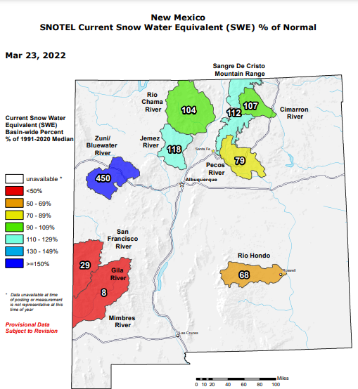
Elevation isn't inherently a snow indicator. Santa Fe is 7,000+ feet and averages the same amount of snow as Philadelphia, roughly 23". Meanwhile, Flagstaff is about the same elevation and gets 100 inches annually.
Elevation is a big contributor and how much snow you get And I’m sure if they had more than 8 inches of rain Santa Fe (a year)Your chances of having more snow I-would think Go up dramatically
-
4 hours ago, raindancewx said:
My snowfall map has verified quite well where I am. Looks like we've topped 10 inches of snow in Albuquerque for the second year in a row. Above average both years. First time that's happened in back to back La Nina winters since 1973-74 to 1974-75.
Edit: The 3.1" snow was the storm total, not today's total at the airport. Only 9.4" for Oct-Mar 2021-22, but 3.7" in March - most since 2005 here.
Most of the metro got 1-5 inches of snow overnight. Big heavy wet snowflakes. We've had rain too this month, so the ground and plant life is quite happy.
You would think you would have more than 10 inches especially at the elevation of 5300+
-
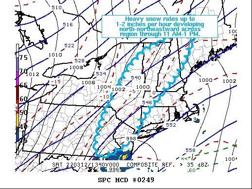
Just now, RedSky said:
Backedge on radar already wow
I guess it’s going to be over a lot earlier than anticipated
-
-
2 minutes ago, snowman19 said:
If the new NAM is correct, there may be very little snow with this for the metro area. It only has an inch or so total even for up in Orange County, less than that south of there and that’s using the Kuchera. It absolutely torches the midlevels very quickly after precip begins, I would not be surprised to see Rockland/Bergen on south and east start as sleet then go to rain quickly https://www.pivotalweather.com/model.php?m=nam&p=snku_acc&rh=2022011618&fh=24&r=us_ne&dpdt=&mc=
I think everybody’s quite aware of what’s going to be taking place I don’t think anybody in the New York metro area was counting on 3 or 4 inches
-
5
-
-
8 hours ago, Chief83 said:
Worcester, PA. 4:30 PM. Got up to 20.7 today. Now 18.1 with a -4.9 dewpoint. Regardless of the storm event / miss It is COLD. Lets see what happens with the storm-sometimes there are surprises. (despite the models).
Congratulations on your new ladder that you ordered
-
47 minutes ago, snowman19 said:
This is not good, stronger than normal SPV continues, no signs of any SSW or SPV disruption over the next 3+ weeks:
Why don’t you post the rest of his Tweet
-
1
-
1
-
-
1 hour ago, MJO812 said:
Anyday now

Here’s a question for you fellas what’s the Longest the MJO has ever hung around in a certain phase?
-
2 hours ago, EasternLI said:
Those Pacific warm pool waters we talked about in here really are the driving force of all of this. Be interesting to see what does actually break this loop. Phase 7 until further notice until some event shows up to disrupt this. But phase 7 is very capable of strat disruption as per the literature. La Niña plus EQBO is also favorable for doing that. The -PNA is a complimentary component to this. So do we break the loop before enough damage is done? Or does the strat eventually break the loop? I'd be a little surprised honestly if the MJO were to make a push east with this going on. Thinking it needs an intervening force. Just not sure what ultimately happens with this or what that force will be.
I noticed there’s a high pressure 1031 to 1038 just sitting off the coast of Washington and Oregon just sitting there spinning and not moving at all Practically the whole 18 Z run on GFS Until something kicks it out of the way i think we’re stuck in this pattern


July 2022
in New York City Metro
Posted
I swear to you I know what’s going to happen, December January February say bye-bye to the blocking and say hello to that Southeast Ridge