

thunderbolt
-
Posts
821 -
Joined
-
Last visited
Content Type
Profiles
Blogs
Forums
American Weather
Media Demo
Store
Gallery
Posts posted by thunderbolt
-
-
1 hour ago, Ed, snow and hurricane fan said:
Most of the ensembles are farther South, but if there is still a weenie of the year award, I nominate myself.

What did Houston due to the weather gods
-
My humble opinion is once the eastern Pacific calms down then the Atlantic will ramp up but until then Crickets
-
15 minutes ago, weathermedic said:
I know it's still a little early but temps seem to be under performing today?
Yeah I’m currently at 91 national weather service has me at 94 I should be able to make up 3° in the next 4 to 5 hours
-
2 minutes ago, ldub23 said:
GFS keeps it very weak. 1009mb at "landfall". I think conditions might not be all that favorable in the GOM.

Wow
-
Just now, The Iceman said:
Wow another 1.25" will probably get to 1.3" by the time we taper off. 3.75" on the day including this morning. Levittown area has been a magnet today for the heavy rain.
You got that right ice I’m over here in the Quincy Hollow development just got inundated
-
 1
1
-
-
15 minutes ago, Ed, snow and hurricane fan said:
PTC 6 in 30 minutes.
Sorry for my ignorance but PTC stands for?
-
3 minutes ago, Maestrobjwa said:
Huh? Thought we were in la nina?
I thought the same thing
-
3 minutes ago, Maestrobjwa said:
Huh? Thought we were in la nina?
I thought the same thing
-
1
-
-
22 minutes ago, Floydbuster said:
I'm kinda surprised that the NHC is so liberal with development. I'm not convinced anything will come of either area of interest. I'm also not impressed with the long-range models but they seem to be awful on genesis. Two years ago, the long-range GFS a few days out showed a sunny beautiful day in Abaco Island when it actuality there was a 180 mph hurricane overhead. Last year, the models showed nothing of a 90 mph Hurricane Hanna slamming into Texas.
I have little faith with the forecast models when it comes to genesis.
I was kind of thinking the same thing my reasoning was once the Eastern Pacific shuts down then we would see the Atlantic Would wake up
-
1 hour ago, Windspeed said:
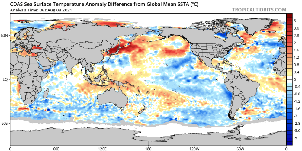
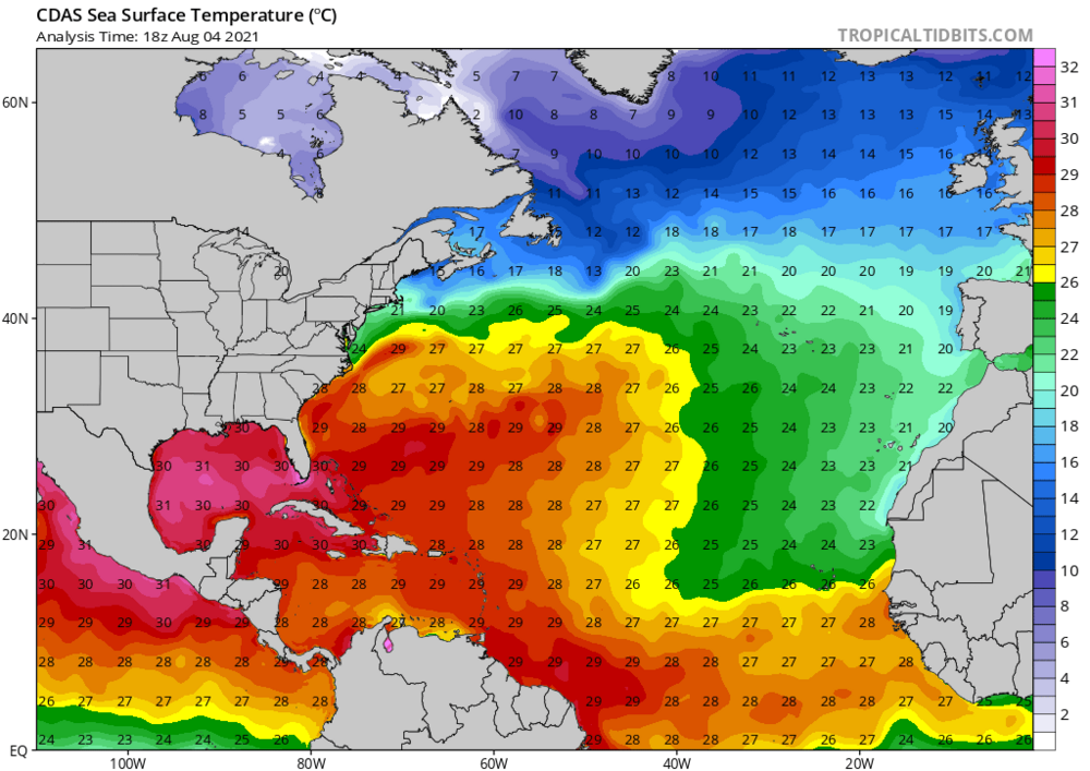
The 18z GFS and HAFS-B globalnest have very robust cyclonic signatures with the strong MCS about to advance off Africa over the next few days. Monsoonal flow has become robust into the Cabo Verdes. Latitude for wave break and axis will still be critical for downstream development however as SSTs are still quite marginal due west of the islands. A surface trough more SSW of CV would obviously increase potential, as 27°C+ SSTs better support thermodynamics needed for cyclogenesis.

-
4 hours ago, CIK62 said:
I will do the Next 8 Days after I recover.
WARNING>>>>>>>>>>>>>>>>And This Is Not Dallas..................

That would hurt if those Temps came to fruition
-
4 hours ago, bluewave said:
The latest PNA forecast is even more extreme. The GEFS maxes out near a ridiculous +4. The highest ever in August was just +3.1. I think that this is why the models have such a sharp rainfall cutoff west of NYC. A piece of the Western heat comes east when the PNA begins to flatten later this week.


Just imagine if you would’ve shifted that 150 miles west oh boy
-
1
-
-
8 minutes ago, Ed, snow and hurricane fan said:
Twitter, hints tomorrow some people lower numbers, but while peak September season may be in a suppressive MJO phase, mid-late August looks favorable and hints of STR weakness near/just West of East Coast, while peak season may be slow, before peak season (mid August) may be busy, and ECUSA could be involved. If MJO is 40 days, who knows the October pattern for Florida or ECUSA.
And I totally concur with this statement about the MJO I was just gonna post About this it looks like it’s going to be more favorable Phases mid to late Aug
-
1
-
-
36 minutes ago, bluewave said:
Yeah, the Euro and EPS also have a return to higher dew points. The coming near record +PNA is so extreme, that it could mark a pattern change. The EPS allow the WAR to take over for much of August. So we could be looking at an extended heatwave from mid to late August.

Aug 9-16

Aug 16-23

With the PNA dropping down to neutral what do you think the chances are with severe weather I’m assuming that would also pick up What do you think blue
-
10 minutes ago, bluewave said:
Models beginning to come into better focus on our next heatwave. Looks like a chance of 90s by Friday into the weekend. Major 95+ heat could be possible for the 2nd week of August. EPS has +18C 850 mb temperatures with the OP going for +20C.

Looks like the humidity could also be creeping up at that time too
-
1
-
-
4 hours ago, Rtd208 said:
GeezzzI haven’t seen a hatch Like that in quite some time
-
15 minutes ago, johnduzzee said:
Talk to me on your thoughts on a tropical storm hitting the Yucatan Peninsula in the next 3 weeks.
Ok
-
Just one of the ingredients for a possible active hurricane season
-
1
-
-
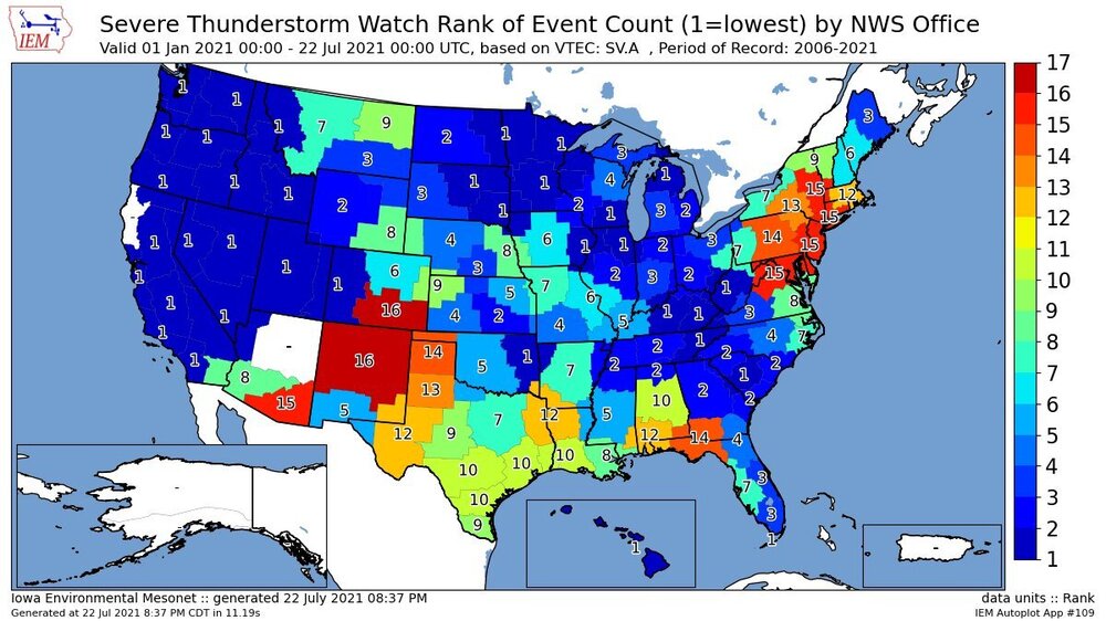
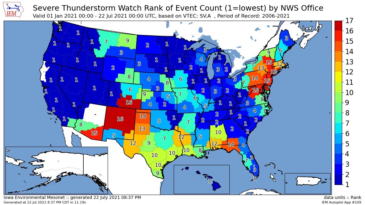
I guess the upper middleAtlantic Is one of the top severe thunderstorm watches In the nation
-
1
-
-
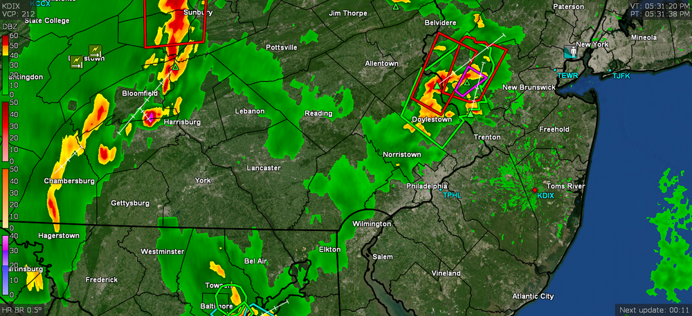
27 minutes ago, uncle W said:
did it happen?
Yes they had severe thunderstorm warnings up there and they had a lot of smoke from the fires
-
39 minutes ago, uncle W said:
I wonder if the smokey conditions will put a damper on tomorrows possible thunderstorms?...TWT...
I don’t think so the only reason I’m saying that is in upstate New York They were put on her a severe thunderstorm watch and I know they had some warnings up that way
-
Believe it or not we got dispatched for fire investigation due to the smoke this was down in the Langhorne area of PA
-
1
-
-
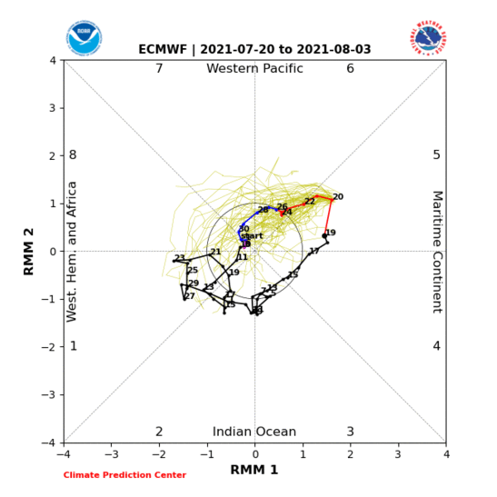
1 hour ago, bluewave said:
This is one of the more impressive MJO 5 summer patterns that we have seen in a while. It keeps the heat dome over the Rockies and Upper Plains. The Atlantic tropical action also gets shut down for a while with plenty of Saharan dust.


-
2
-
-
20 minutes ago, Hurricane Agnes said:
There was a TOR up around your area sometime between 5 and 5:30 pm. I think there was a report of a funnel by a spotter.
Looks like my low was 72 this morning and the sun is trying to peak out between the debris clouds. Current temp is 75 with dp 73.
Well round 3 was the best round unfortunately there was a house fires in Langhorne and also one in Bensalem Because of lightning strikes


Major Hurricane Ida
in Tropical Headquarters
Posted
Ouch that Just might hurt!!!!!